
Development Management Plan Consultation Document 3rd February - 27th April 2012
Part B – Site Allocations
Introduction
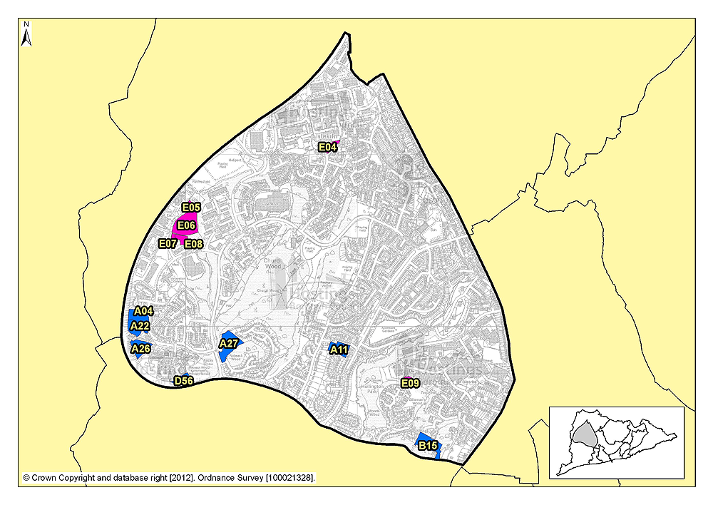
7.1 This section sets out site details for potential development sites in each of the 13 Planning Focus Areas, which are:
- Little Ridge & Ashdown
- Greater Hollington
- Filsham & Bulverhythe
- St Helens
- Silverhill & Alexandra Park
- Maze Hill & Burtons’ St Leonards
- Central St Leonards & Bohemia
- Hastings Town Centre
- Old Town
- West Hill
- Hillcrest & Ore Valley
- Clive Vale & Ore Village
- Hastings Country Park
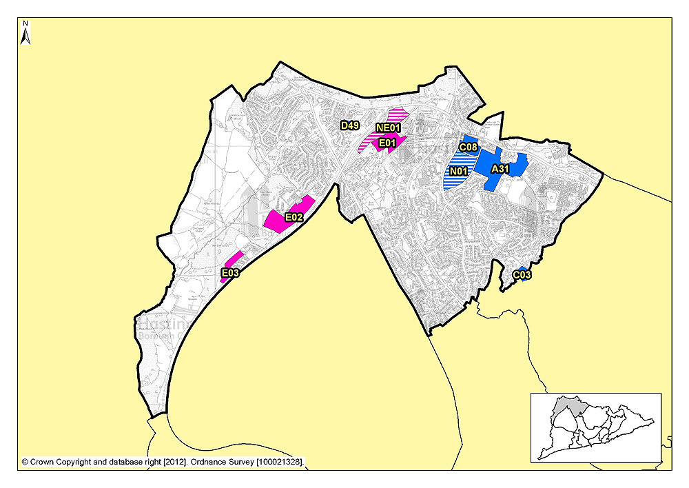
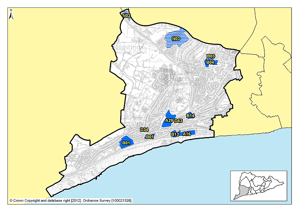
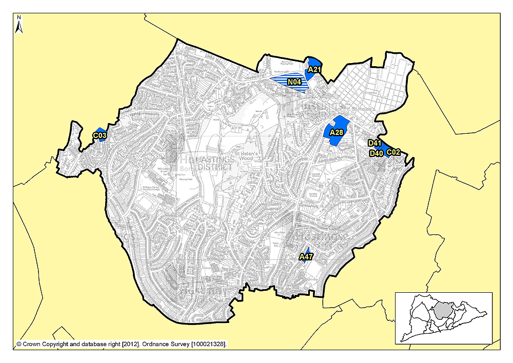
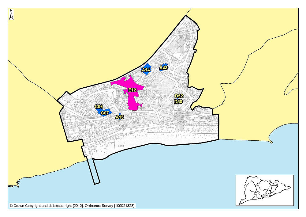
7.2 Figure PFA, below, gives a borough-wide overview of these focus areas, a more detailed version can be found in appendix A.
7.3 Within each focus area, we have provided a summary each potential development site, which includes the Possible net number of dwellings, site area and planning status and site boundary for both housing and employment locations.
7.4 Please note that some sites may propose mixed use development, rather than just a single use on its own.
7.5 Maps are provided at the end of this document, showing all of these sites in context across the town, as well as an additional map showing protective designations and allocations. Focus area maps are also provided to enable you to see the information at a slightly larger scale, specific to your area.
Your comments
7.6 We want to hear your views on any, or all of these sites. Do you support their allocation? Are there factors that must be taken into account before any development would be acceptable? If you think any details should be changed, please say why using the response form where possible or the relevant section of the online system.
Other site suggestions
(24) 7.7 Are there any other possible development sites that you know of that are not considered in this document? If so, please tell us about them here, providing as much information as you can including, an address and your suggested use for the site.
Planning Focus Areas

Little Ridge & Ashdown (Planning Focus Area 1)
Table 1: Possible net number of dwellings on sites in Focus Area 1
| Site reference | Address | Possible net number of dwellings | Area (ha) | Planning status |
|---|---|---|---|---|
| D49 | Former Workplace Health & Fitness Centre, The Ridge West | 11 | 0.47 | Full planning permission subject to legal agreement |
| C08 | Land adjacent to 777 The Ridge | 10 | 1.86 | None |
| A31 | Holmhurst St Mary | 170 | 6.98 | Allocated in Hastings Local Plan 2004 |
| C03 | Old Roar House, Old Roar Road | 14 | 0.84 | Lapsed planning permission |
| N01 | Harrow Lane Playing Fields | 4.75 | Allocated in Hastings Local Plan 2004 (playing field) |
Table 2: Potential gross employment floorspace on sites in Focus Area 1
| Site reference | Address | Potential gross floorspace (m2) | Area (ha) | Planning status |
|---|---|---|---|---|
| E01 | Land in Whitworth Road, The Ridge West | 8,085 | 2.5 | Allocated in Hastings Local Plan 2004 |
| E02 | Queensway North, Queensway | 9,700 | 4.7 | Allocated in Hastings Local Plan 2004 |
| E03 | Marline Fields, Enviro21 Business Park, Land West of Queensway | 5,600 | 1.5 | Allocated in Hastings Local Plan 2004 |
| NE01 | Land at junction of The Ridge West and Queensway | To be determined | 3.4 | Permission on part of site only |
Planning Focus Area 1
(8) Site reference: D49
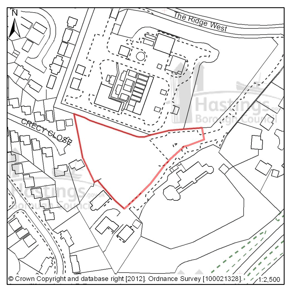
Figure 1: Location plan for D49
Site address: Former Workplace health & fitness centre, The Ridge West
Suggested use: Residential
Planning status: Full planning permission subject to a legal agreement
Area: 0.47ha
Possible net capacity: 11
Assessment summary: The suitability of developing this site for housing has been established through an earlier resolution by the Planning Committee to approve a planning application subject to a legal agreement. Our preference would be to allocate this site for residential development with an indicative site capacity of 11 units.
Previously your comments were:
None
(23) Site reference: C08
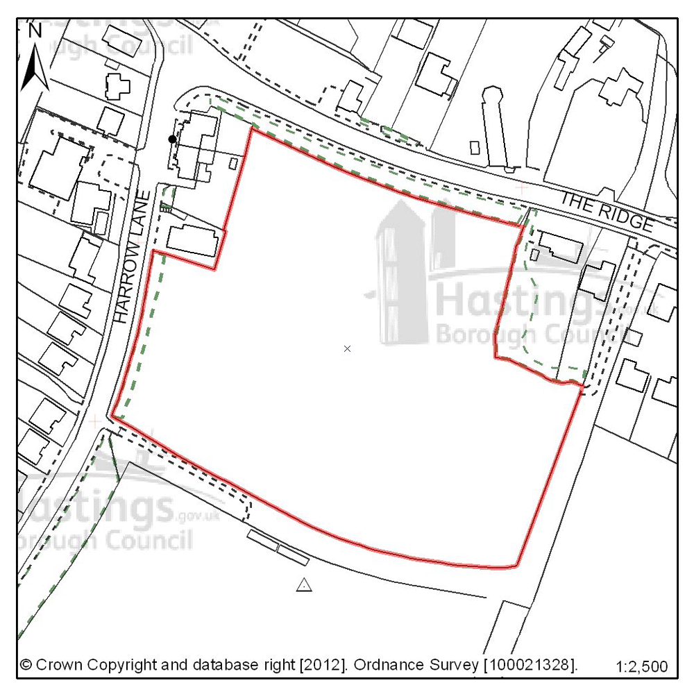
Figure 2: Location plan for C08
Site address: Land adjacent to 777 The Ridge
Suggested use: Residential
Planning status: None
Area: 1.86ha
Possible net capacity: 10
Assessment summary: This is a greenfield site occupying an elevated position at the junction of Harrow Lane with The Ridge. Though physically suitable for development, the site is outside of the currently defined Built-up Area - at present this is a constraint to its development and revising the boundary here would need to be justified. The site does not fall within any landscape designation but the Area of Outstanding Natural Beauty (AONB) lies on the opposite side of The Ridge, there are long views to the north into and out of the AONB, this is likely to constrain the scale and form of development on this site. Planting on the northern boundary could enable part of the site to be developed but low profile development would be essential on this elevated site.
Previously your comments were:
- Landscape issues
- Should be developed as open space & allotments – there are no useable allotments sites in this part of Hastings
- Area is known to flood and be very water logged in bad weather
(14) Site reference: A31
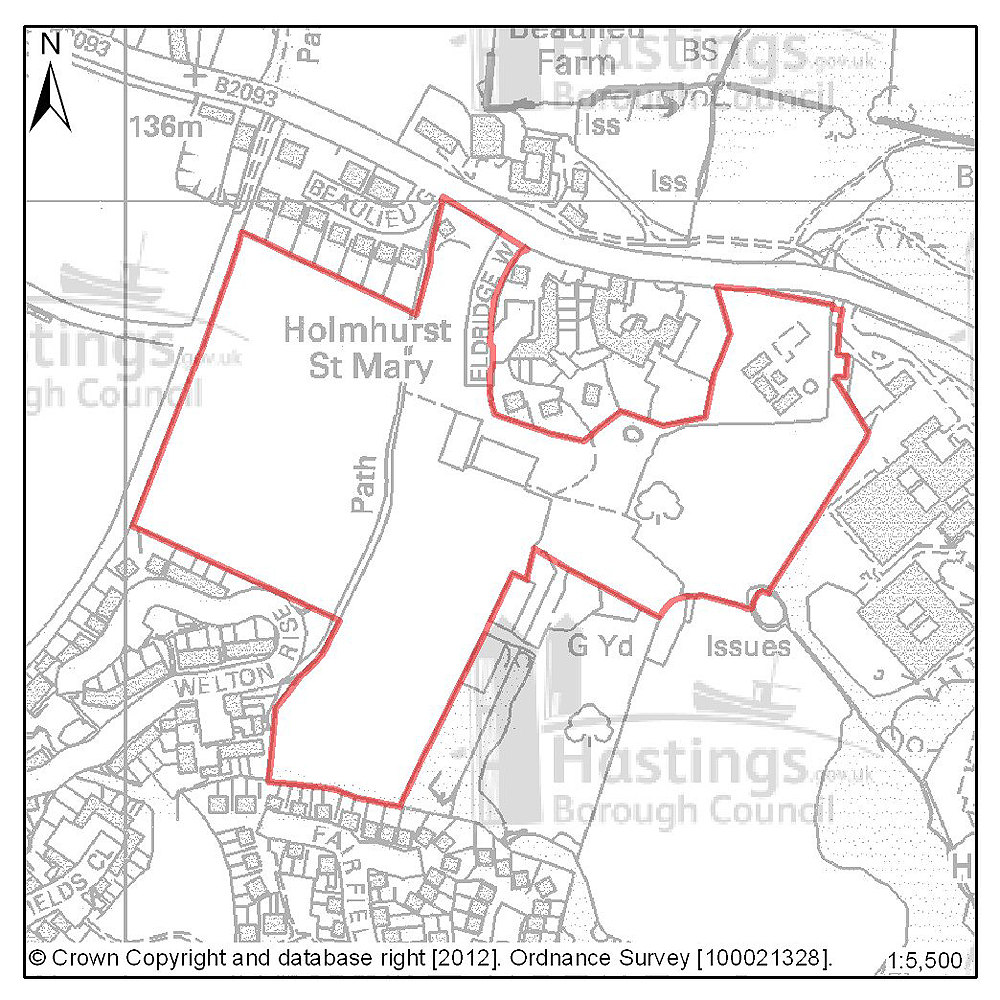
Figure 3: Location plan for A31
Site address: Holmhurst St Mary
Suggested use: Residential
Planning status: Allocated in the Hastings Local Plan 2004
Area: 6.98ha
Possible net capacity: 170
Assessment summary: This greenfield site is allocated as a reserve site for residential development in the existing Local Plan. In short this meant the site was to be held in reserve whilst the much needed redevelopment of brownfield land came first. Progress has been made in redeveloping brownfield around the town, and this site continues to remain suitable for residential development. Our preference is there for to allocate this site for residential development with an indicative capacity of 170 units. The form of any proposed development would need to take into account such matters as the established landscaping, ecology and position of a listed statue.
Previously your comments were:
- Traffic impact
- Burial area within site
- Needs more large family housing
- Needs to be safe for children to play
- Support family housing in this location
- Develop as open space
(10) Site reference: C03
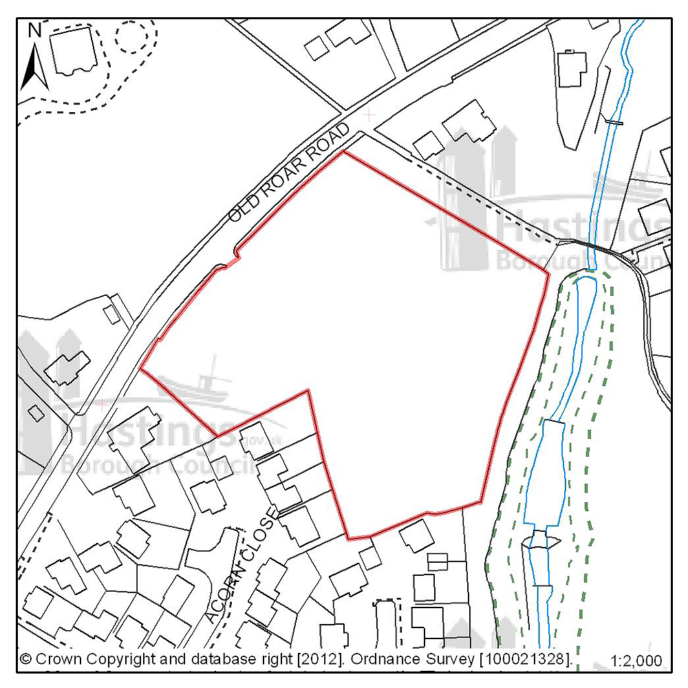
Figure 4: Location plan for C03
Site address: Old Roar House, Old Roar Road
Suggested use: Residential
Planning status: Lapsed planning permission
Area: 0.84ha
Possible net capacity: 14
Assessment summary: Although planning permission for residential development has recently lapsed on this site, the site’s suitability for residential development has been established. Our preference would be to allocate this site for residential development with an indicative capacity of 14 units.
Previously your comments were:
None
(17) Site reference: N01
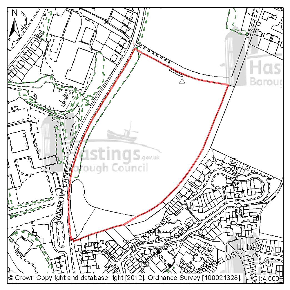
Figure 5: Location plan for N01
Site address: Harrow Lane Playing Fields
Suggested use: Residential
Planning status: Allocated in the Hastings Local Plan 2004 (playing field)
Area: 4.75 ha
Possible net capacity: 140
Assessment summary: Harrow Lane playing fields is an elevated site situated above the road, and office and residential area to the east. The boundary of the site is made-up of well treed hedgerows, except at the south west corner where there are long views to Beachy Head. It is currently not used for football fields/active recreation and could be surplus to open space provision requirement. This site could be suitable for residential development, incorporating measures to help maintain its current overall appearance of a wooded site and strengthening boundary planting. There are also public rights of way running and around the perimeter which would have to be accommodated within any development proposals. We also need to decide if the existing recreational uses (open space and playing fields) would need to be relocated. The site is currently outside of the built-up area boundary which normally means there is a presumption against residential development. The Development Management Plan offers an opportunity to reappraise the built-up area boundary at this location, however any amendment to the built-up boundary would need to be robustly justified. If a density of 30 dwellings per hectares is assumed the site is capable of delivering c.140 units. The site is put forward for comment and reaction. The Council is not making a recommendation at this time.
(10) Site reference: E01
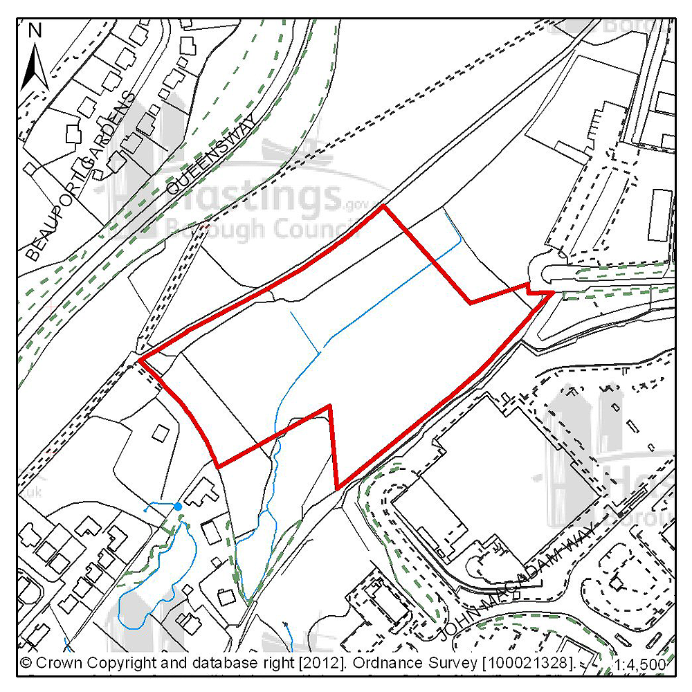
Figure 6: Location plan for E01
Site address: Land in Whitworth Road, The Ridge West
Suggested use: Employment
Planning status: Allocated in the Hastings Local Plan 2004
Area: 2.5ha
Possible net capacity: 8,085m2
Assessment summary: This site has been allocated for employment development for many years but until recently was affected by possible routes for the Baldslow Junction highway improvement scheme. That scheme was cancelled under the Government’s National Spending Review in 2010. With the scheme no longer affecting the site, it is now capable of being brought forward as a natural extension of the West Ridge employment area. The site is partly affected by a site of nature conservation importance and a wildlife corridor designated in the Hastings Local Plan 2004. A full ecological survey would be required to assess the extent to which that would constrain any development.
This site adjoins land to the north which is also included in this consultation for possible employment development. The two sites combined would have capacity to enable creation of a high quality employment estate with direct frontage onto The Ridge which would considerably enhance its commercial potential.
Previously your comments were:
None
(10) Site reference: E02
Figure 7: Location plan for E02
Site address: Queensway North, Queensway
Suggested use: Employment
Planning status: Allocated in the Hastings Local Plan 2004
Area: 4.7ha
Possible net capacity: 9,700m2
Assessment summary: This site has been allocated for employment a considerable period. Its “partner” site, Queensway South, has been partially developed as part of the Enviro21 Business Park scheme and this could form a next phase. The site adjoins a Site of Special Scientific Interest and being mainly scrub and some woodland will need to be fully surveyed ecologically to assess what constraints to development these represent. Access would be directly off Queensway. It is seen as suitable for high quality business development.
Previously your comments were:
None
(8) Site reference: E03
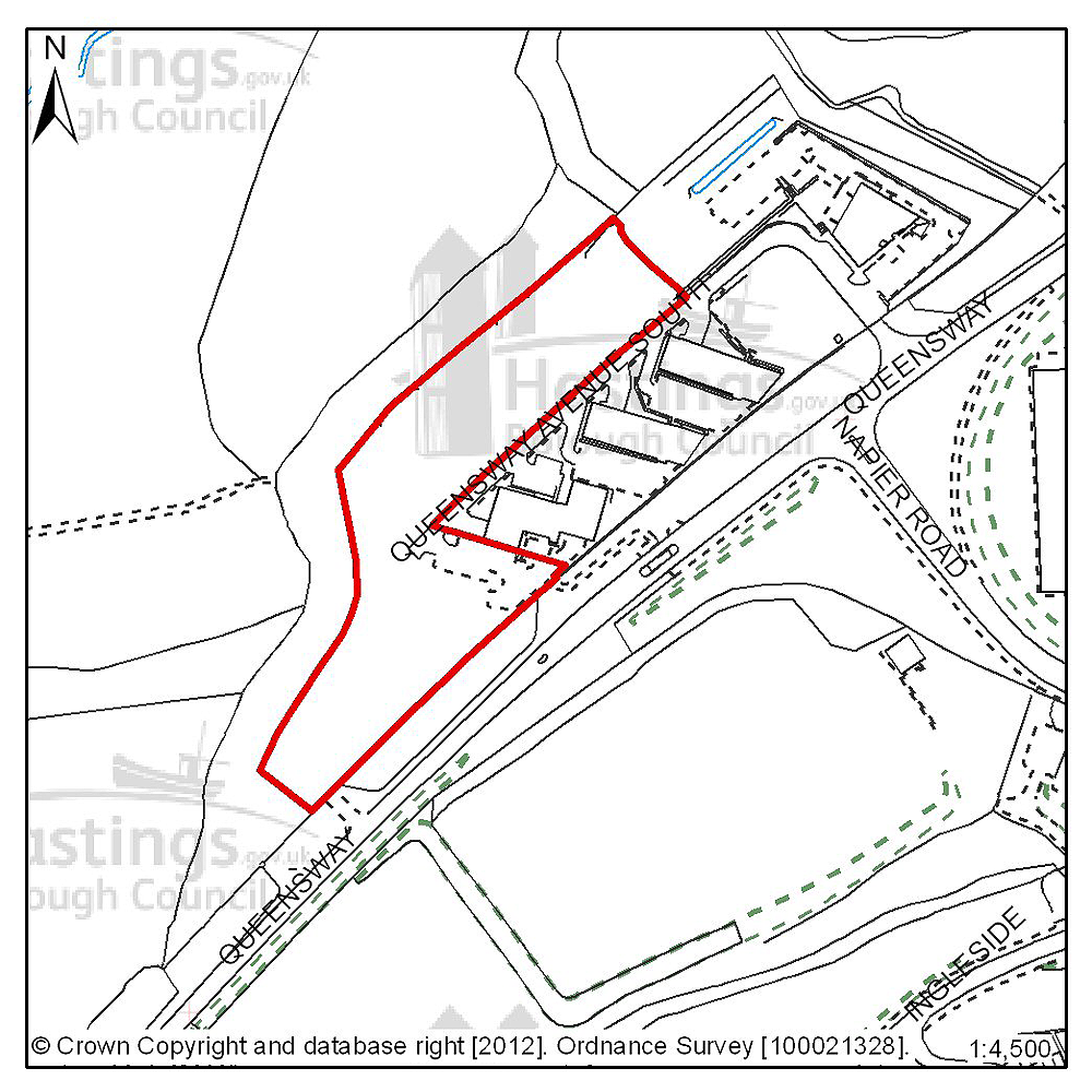
Figure 8: Location plan for E03
Site address: Marline Fields, Enviro21 Business Park, Land West of Queensway
Suggested use: Employment
Planning status: Allocated in the Hastings Local Plan 2004. Planning permission granted for 6 business units.
Area: 1.5ha
Possible net capacity: 5,600m2
Assessment summary: This is part of a larger site. 4 high quality business units and the access spine road have already been constructed, under the Enviro21 Business Park scheme. The plots themselves are cleared and prepared. It is therefore effectively a serviced site ready for development.
Previously your comments were:
None
(11) Site reference: NE01
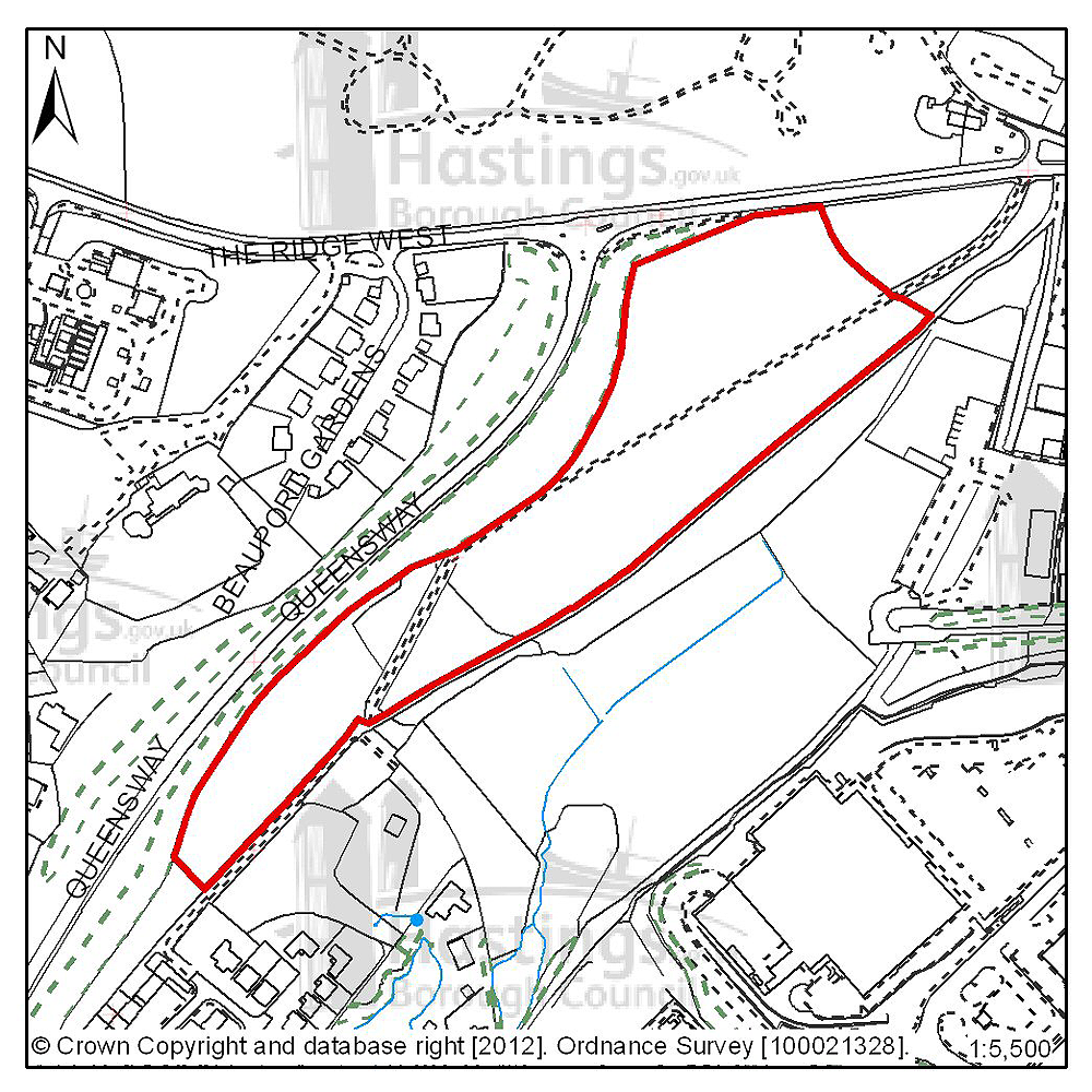
Figure 9: Location plan for NE01
Site address: Land at junction of The Ridge West and Queensway
Suggested use: Employment
Planning status: Permission on part of site only
Area: 3.4ha
Possible net capacity: To be determined
Assessment summary: This is a greenfield site in the ownership of East Sussex County Council. Taken together with an adjoining existing employment allocation - to the south-east of this land, this location would offer the potential to create a significant new area for employment related development. However, planning permission already exists on the northern portion of this site for a close care residential scheme. If the County Council's plans in this respect were not to take place, and all of this land were to be available for development during the Plan period, our preference would be to see the land developed for employment purposes. The site is put forward for comment and reaction. The Council is not making a recommendation at this time.
Greater Hollington (Focus Area 2)
Table 3: Possible net number of dwellings on sites in Focus Area 2
| Site reference | Address | Possible net number of dwellings | Area (ha) | Planning status |
|---|---|---|---|---|
| A04 | Mayfield E, Bodiam Drive | 37 | 1.10 | Allocated in Hastings Local Plan 2004 (lapsed planning permission) |
| A22 | Mayfield Farm | 8 | 0.54 | Allocated in Hastings Local Plan 2004 (lapsed planning permission) |
| A26 | Mayfield J, Mayfield Lane | 36 | 0.77 | Outline planning permission subject to legal agreement |
| A27 | Robsack A, Church Wood Drive | 32 | 1.24 | Outline planning permission subject to legal agreement |
| D56 | Land south of 12-17 Catsfield Close | 10 | 0.41 | Outline planning permission |
| A11 | Land at Redgeland Rise (Wishing Tree Nursery) | 28 | 0.71 | Outline planning permission subject to legal agreement |
| B15 | Spyways School, Gillsmans Hill | 33 | 1.09 | Full planning permission subject to legal agreement |
Table 4: Potential gross employment floorspace on sites in Focus Area 2
| Site reference | Address | Potential gross floorspace (m2) | Area (ha) | Planning status |
|---|---|---|---|---|
| E04 | Plot M, Gresley Road, Castleham | 1,200 | 0.3 | Allocated in Hastings Local Plan 2004 |
| E05 | Site RX2, Sidney Little Road, Churchfields | 910 | 0.2 | Allocated in Hastings Local Plan 2004 |
| E06 | Sites PX and QX, Churchfields | 6,900 | 1.6 | Allocated in Hastings Local Plan 2004 |
| E07 | Site NX3 Sidney Little Road, Churchfields | 920 | 0.2 | Allocated in Hastings Local Plan 2004 |
| E08 | Site NX2 Sidney Little Road, Churchfields | 770 | 0.3 | Allocated in Hastings Local Plan 2004 |
| E09 | Land at the rear of Drury Lane, Ponswood | 770 | 0.3 | Allocated in Hastings Local Plan 2004 |
Planning Focus Area 2
(6) Site reference: A04
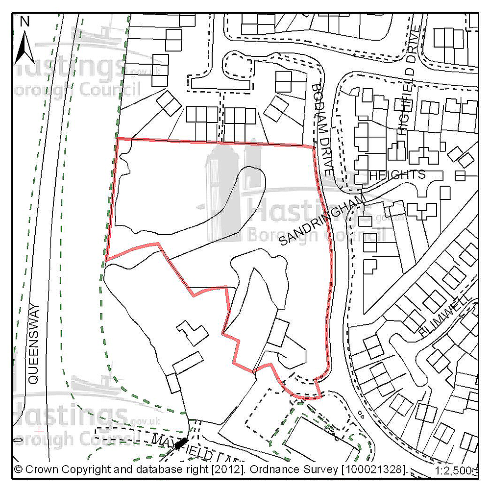
Figure 10: Location plan for A04
Site address: Mayfield E, Bodiam Drive
Suggested use: Residential
Planning status: Allocated in the Hastings Local Plan 2004 (lapsed planning permission)
Area: 1.10ha
Possible net capacity: 37
Assessment summary: This site is allocated for residential development in the existing Local Plan. Though an earlier planning permission has now lapsed, the site remains suitable for residential development. Our preference is to continue to allocate this site for housing with an indicative capacity of 37 units.
Previously your comments were:
None
(5) Site reference: A22
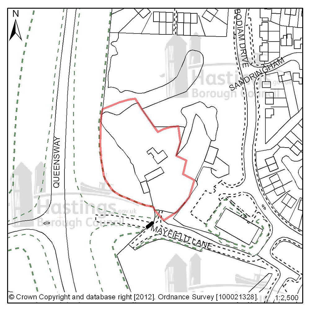
Figure 11: Location plan for A22
Site address: Mayfield Farm
Suggested use: Residential
Planning status: Allocated in the Hastings Local Plan 2004 (lapsed planning permission)
Area: 0.54ha
Possible net capacity: 8
Assessment summary: This site is allocated for residential development in the existing Local Plan. Though an earlier planning permission has now lapsed, the site remains suitable for residential development. Our preference is to continue to allocate this site for housing with an indicative capacity of 8 units.
Previously your comments were:
None
(3) Site reference: A26
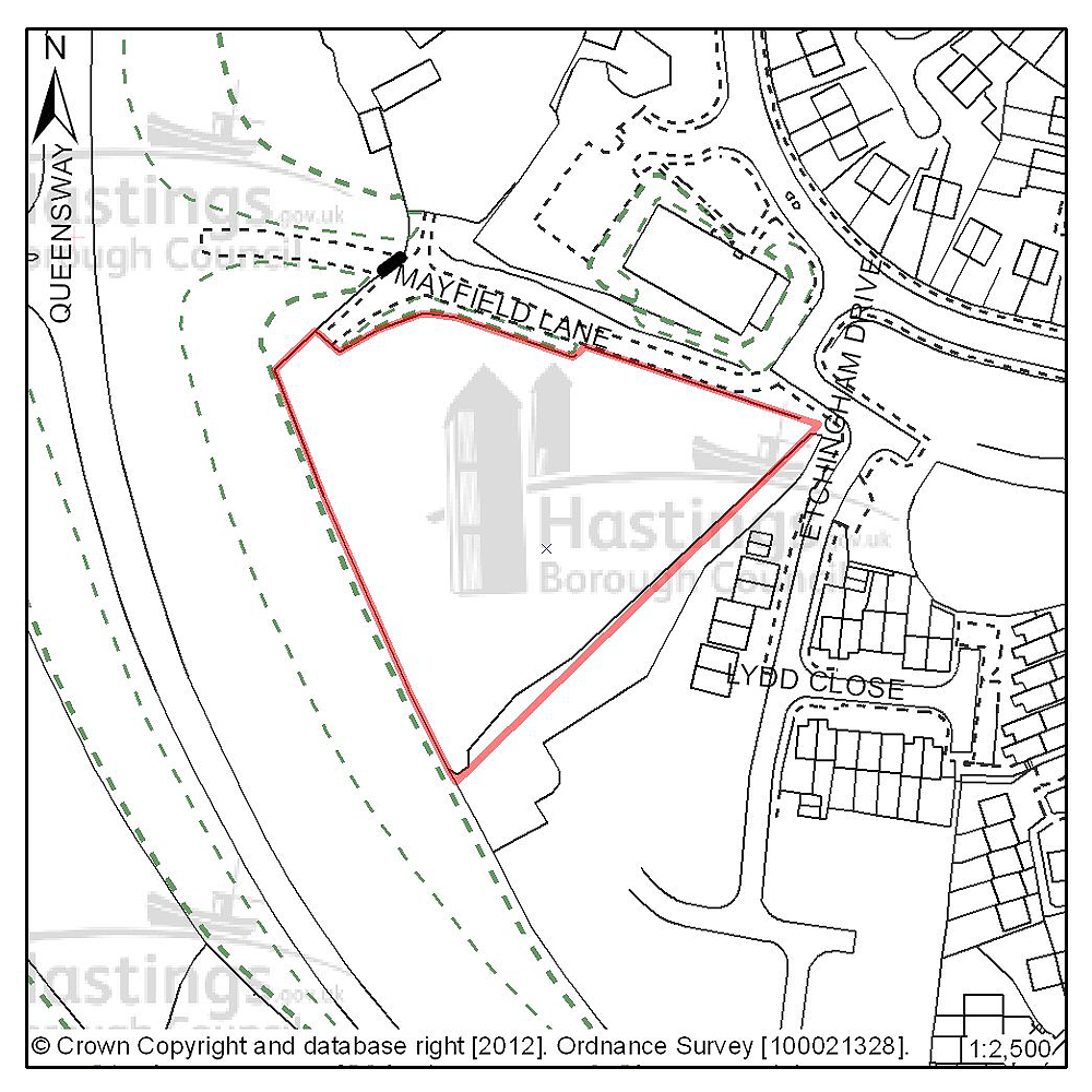
Figure 12: Location plan for A26
Site address: Mayfield J, Mayfield Lane
Suggested use: Residential
Planning status: Outline planning permission subject to a legal agreement
Area: 0.77ha
Possible net capacity: 36
Assessment summary: This site is allocated for residential development in the existing Local Plan. A planning proposal involving the redevelopment of the site has been approved subject to a legal agreement. Our preference would be to continue to allocate this site for residential development with an indicative site capacity of 36 units.
Previously your comments were:
None
(28) Site reference: A27
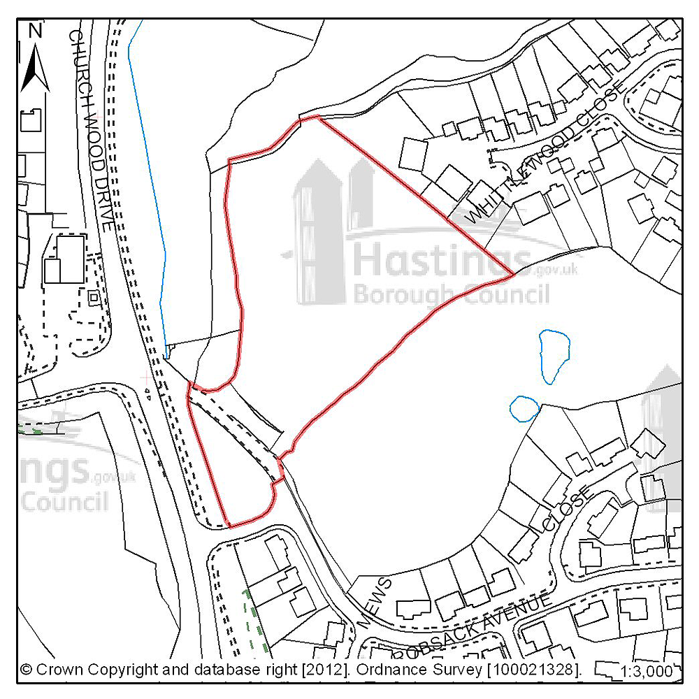
Figure 13: Location plan for A27
Site address: Robsack A, Church Wood Drive
Suggested use: Residential
Planning status: Outline planning permission subject to a legal agreement
Area: 1.24ha
Possible net capacity: 32
Assessment summary: This site is allocated for residential development in the existing Local Plan. The entrance to the site contains some trees covered by tree preservation orders and woodland designated as Ancient Woodland. Church Wood and Robsack Wood, also designated Ancient Woodland, abut the site. Providing the issue of ecology can be satisfactorily addressed, the site remains suitable for residential development. Our preference is to continue to allocate this site for housing development with an indicative capacity of 32 units.
Previously your comments were:
- Too dense
- Nature conservation & Ancient Woodland protection of paramount importance
(6) Site reference: D56

Figure 14: Location plan for D56
Site address: Land South of 12-17 Catsfield Close
Suggested use: Residential
Planning status: Outline Planning Permission
Area: 0.41ha
Possible net capacity: 10
Assessment summary: The suitability of developing this site for housing has been established through a current outline planning permission. Our preference would be to allocate this site for residential development with an indicative capacity of 10 units.
Previously your comments were:
None
(4) Site reference: A11

Figure 15: Location plan for A11
Site address: Land at Redgeland Rise (Wishing Tree Nursery)
Suggested use: Residential
Planning status: Outline planning permission subject to a legal agreement
Area: 0.71ha
Possible net capacity: 28
Assessment summary: The suitability of developing this site for housing has been established through an earlier resolution by the Planning Committee to approve a planning application subject to a legal agreement. Our preference would be to allocate this site for residential development with an indicative site capacity of 28 units.
Previously your comments were:
None
(6) Site reference: B15
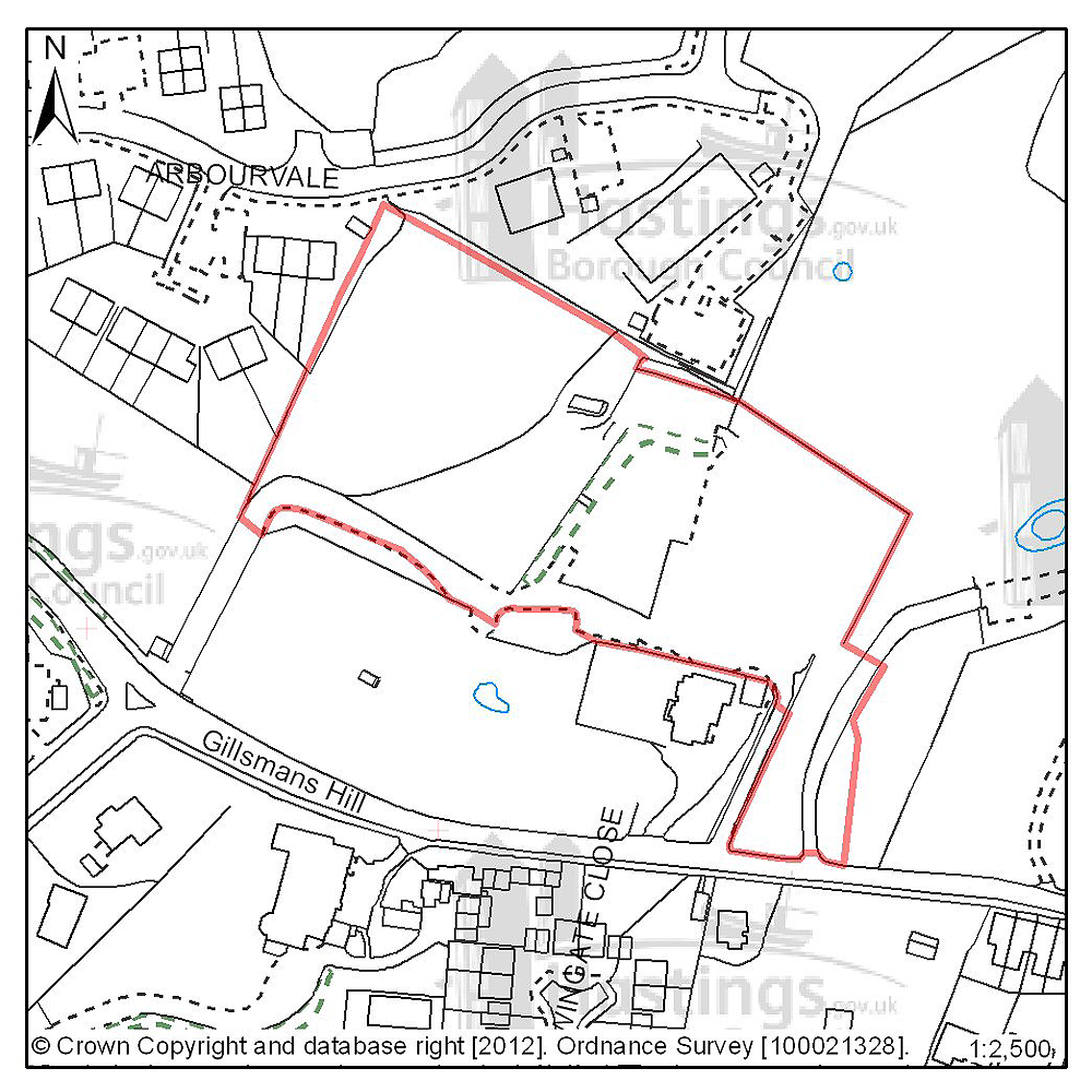
Figure 16: Location plan for B15
Site address: Spyways School, Gillsmans Hill
Suggested use: Residential
Planning status: Full planning permission subject to legal agreement
Area: 1.09ha
Possible net capacity: 33
Assessment summary: The suitability of developing this site for housing has been established through an earlier resolution to approve a planning application subject to a legal agreement. Our preference would be to allocate this site for residential development with an indicative site capacity of 33 units.
Previously your comments were:
None
(3) Site reference: E04

Figure 17: Location plan for E04
Site address: Plot M, Gresley Road, Castleham
Suggested use: Employment
Planning status: Allocated in the Hastings Local Plan 2004
Area: 0.3ha
Possible net capacity: 1,200m2
Assessment summary: This site forms part of the Castleham Employment Area and is suitable for small/medium business units although its sloping nature is a constraint to development. It is a serviced site.
Previously your comments were:
None
(3) Site reference: E05
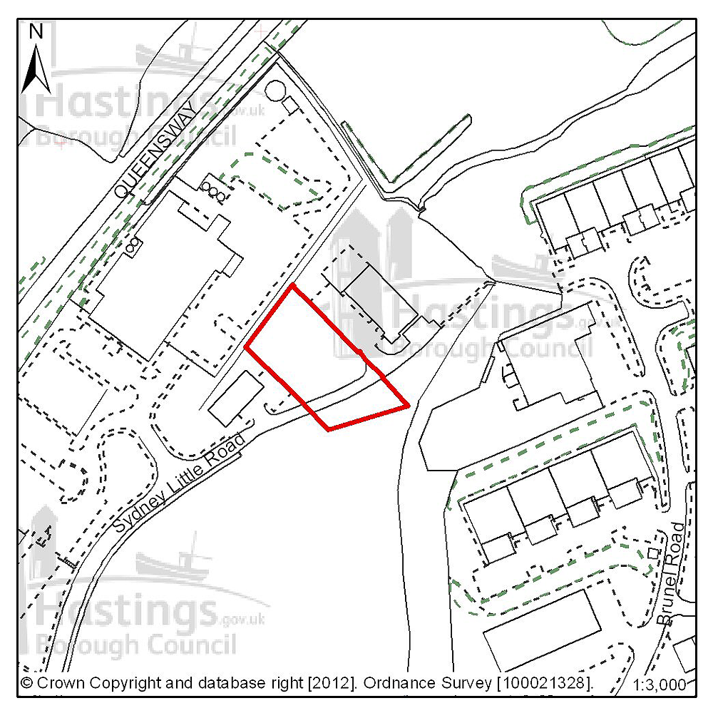
Figure 18: Location plan for E05
Site address: Site RX2, Sidney Little Road, Churchfields
Suggested use: Employment
Planning status: Allocated in the Hastings Local Plan 2004
Area: 0.2ha
Possible net capacity: 910m2
Assessment summary: This site forms part of the Churchfields Employment Area and is suitable for a medium size business unit or several smaller ones. It is a serviced site.
Previously your comments were:
None
(3) Site reference: E06
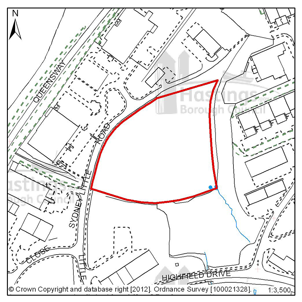
Figure 19: Location plan for E06
Site address: Sites PX and QX, Churchfields
Suggested use: Employment
Planning status: Allocated in the Hastings Local Plan 2004
Area: 1.6ha
Possible net capacity: 6,900m2
Assessment summary: This site forms part of the Churchfields Employment Area and is the largest plot remaining available for development. The site is suitable for a large single business occupier or several smaller ones. Its sloping nature is a constraint to the form of development. It is a serviced site.
Previously your comments were:
None
(3) Site reference: E07

Figure 20: Location plan for E07
Site address: Site NX3, Sidney Little Road, Churchfields
Suggested use: Employment
Planning status: Allocated in the Hastings Local Plan 2004
Area: 0.2ha
Possible net capacity: 920m2
Assessment summary: This site forms part of the Churchfields Employment Area and is suitable for a small/medium size business unit. Its sloping nature is a constraint to development. It is a serviced site.
Previously your comments were:
None
(2) Site reference: E08

Figure 21: Location plan for E08
Site address: Site NX2, Sidney Little Road, Churchfields
Suggested use: Employment
Planning status: Allocated in the Hastings Local Plan 2004
Area: 0.3ha
Possible net capacity: 770m2
Assessment summary: This site forms part of the Churchfields Employment Area and is suitable for a medium size business unit or several smaller ones. Its sloping nature is a constraint to development. It is a serviced site.
Previously your comments were:
None
(2) Site reference: E09
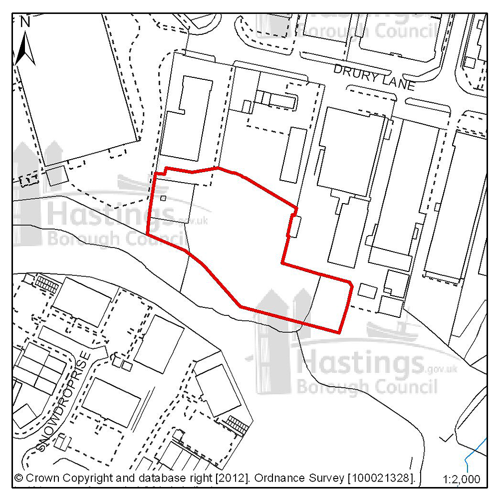
Figure 22: Location plan for E09
Site address: Land at the rear of Drury Lane, Ponswood
Suggested use: Employment
Planning status: Allocated in the Hastings Local Plan 2004
Area: 0.3ha
Possible net capacity: 770m2
Assessment summary: This site forms part of the Ponswood Employment Area and is suitable for a medium size business unit or several smaller ones. It lacks direct access and may prove difficult to develop independently.
Previously your comments were:
None
Filsham & Bulverhythe (Planning Focus Area 3)
Table 5: Possible net number of dwellings on sites in Focus Area 3
| Site reference | Address | Possible net number of dwellings | Area (ha) | Planning status |
|---|---|---|---|---|
| B03 | Former Westerleigh School playing fields | 7 | 0.56 | Lapsed planning permission |
| B04 | Former Westerleigh School | 68 | 2.15 | None |
| A16 | Seaside Road, West St Leonards | 120 | 2.22 | Allocated in Hastings Local Plan 2004 |
| A29 | West St Leonards Primary School | 70 | 3.92 gross area. 1.85 residential area, 0.9 community centre area | Allocated in Hastings Local Plan 2004 |
| D34 | 190 Bexhill Road | 32 | 0.19 | Full planning permission |
| D43 | St Ethelburga’s Church Hall | 7 | 0.08 | Full planning permission |
| B01 | Bulverhythe Development Area | 100 | 4.28 | None |
| B13 | Cinque Ports Way, former Stamco timber yard & TA Centre | 54 | 0.89 | None |
| B14 | Former Hastings College, St Saviours Road | 44 | 1.05 | Full planning permission |
| N02 | Land South of Crowhurst Road | 0.84 | None | |
| N03 | The Grove School | 9.36 | None |
Table 6: Potential gross employment floorspace on sites in Focus Area 3
| Site reference | Address | Potential gross floorspace (m2) | Area (ha) | Planning status |
|---|---|---|---|---|
| None | ||||
Planning Focus Area 3
(5) Site reference: B03

Figure 23: Location plan for B03
Site address: Former Westerleigh School, Playing Fields
Suggested use: Residential
Planning status: Lapsed planning permission
Area: 0.56ha
Possible net capacity: 7
Assessment summary: The suitability of developing this site for housing has been demonstrated through an earlier granting of planning permission. Our preference would be to allocate this site for residential development with an indicative site capacity of 7 units.
Previously your comments were:
- Hollington Park Road is already too busy
(9) Site reference: B04
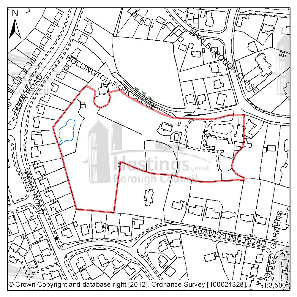
Figure 24: Location plan for B04
Site address: Former Westerleigh School
Suggested use: Residential
Planning status: None
Area: 2.15ha
Possible net capacity: 68
Assessment summary: The closure of this private school means this site is now available for redevelopment. As a brownfield site in an established residential area, our preference is for the site to be redeveloped for residential use. The slope of the land, the existing mature trees within the site together with any nature conservation issues that will need to be explored are likely to influence the amount of development that can take place on the site. A capacity of 68 units is suggested
Previously your comments were:
- Suitable for low rise development
- Suitable for large ice-skating rink complex
- Keep as open or green space
- Hollington Park Road is already too busy
(9) Site reference: A16
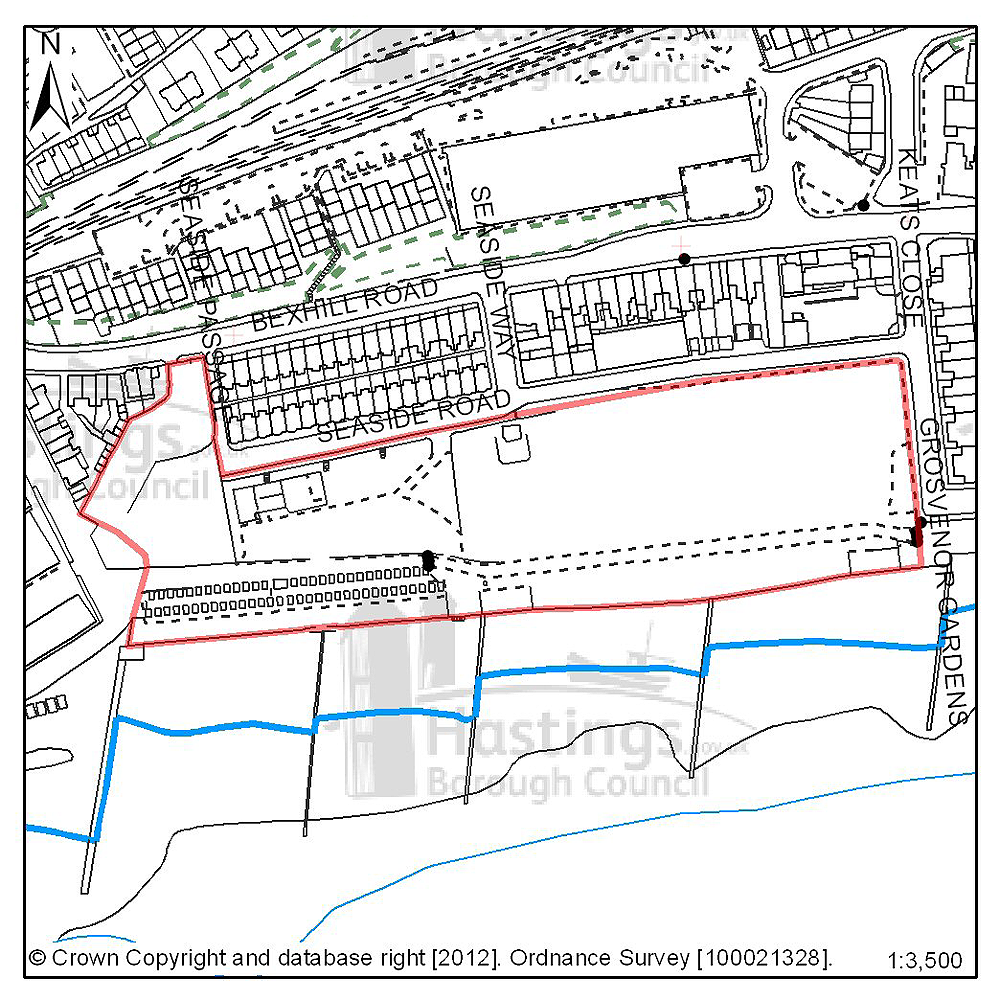
Figure 25: Location plan for A16
Site address: Seaside Road, West St Leonards
Suggested use: Residential
Planning status: Allocated in the Hastings Local Plan 2004
Area: 2.22ha
Possible net capacity: 120
Assessment summary: This site is identified for mixed development including housing in the existing Local Plan. This is a vacant brownfield site with and is part of the wider West Marina redevelopment area - which is an area of vacant and under used land the regeneration of which has been a long term objective of the Council. The West Marina Masterplan indicated that this site could support 120 housing units as part of a mix of commercial and residential units. Our preference is to continue to allocate this site for a mix of uses including residential development with an indicative capacity of 120 units.
Previously your comments were:
- Indicative capacity too dense
- Develop as seaside garden & open space
- Retain for leisure/recreation use
- Reallocate as part of South Saxon wetland
- Develop site as ice skating complex
- Community use
(9) Site reference: A29
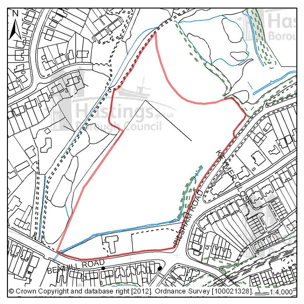
Figure 26: Location plan for A29
Site address: West St Leonards Primary School
Suggested use: Residential and community use
Planning status: Allocated in the Hastings Local Plan 2004
Area: 3.92ha gross area, 1.85ha residential area, 0.9ha community centre area
Possible net capacity: 70
Assessment summary: This site is identified for mixed development including housing in the existing Local Plan. This is a vacant site and is part of the wider West Marina redevelopment area - which is an area of vacant and under used land the regeneration of which has been a long term objective of the Council. The West Marina Masterplan indicated that this site could support 120 housing units as part of a mix of commercial and residential units. Our preference is to continue to allocate this site for a mix of uses including residential development with an indicative capacity of 70 units.
Previously your comments were:
- Reduce size of housing site & enlarge nature area
- Reallocate as part of South Saxon wetland
- Flood risk
- Traffic congestion
- Loss of green space/part of South Saxons wetlands
- Housing should be set back from the road
(7) Site reference: D34

Figure 27: Location plan for D34
Site address: 190 Bexhill Road
Suggested use: Residential
Planning status: Full planning permission
Area: 0.19ha
Possible net capacity: 32
Assessment summary: This site has full planning permission for residential development. Our preference would be to allocate this site for residential development with an indicative capacity of 32 units
Previously your comments were:
None
(4) Site reference: D43
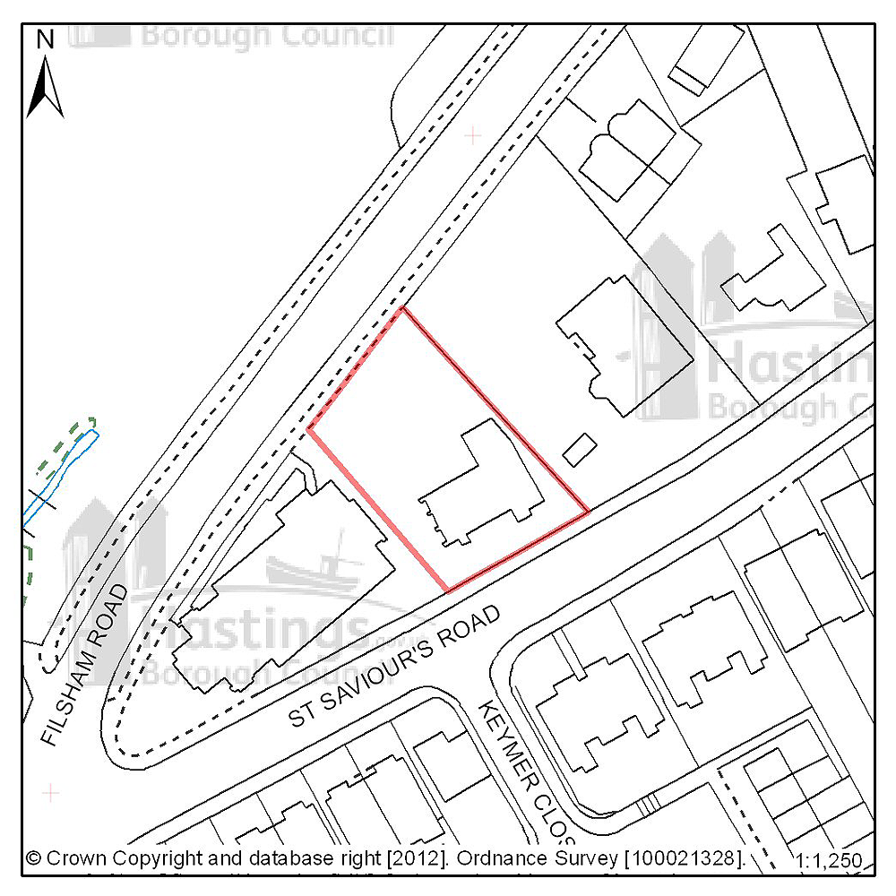
Figure 28: Location plan for D43
Site address: St Ethelburga’s Church Hall
Suggested use: Residential
Planning status: Full planning permission
Area: 0.08ha
Possible net capacity: 7
Assessment summary: This site has full planning permission for residential development. Our preference would be to allocate this site for residential development with an indicative capacity of 7 units
Previously your comments were:
None
(10) Site reference: B01
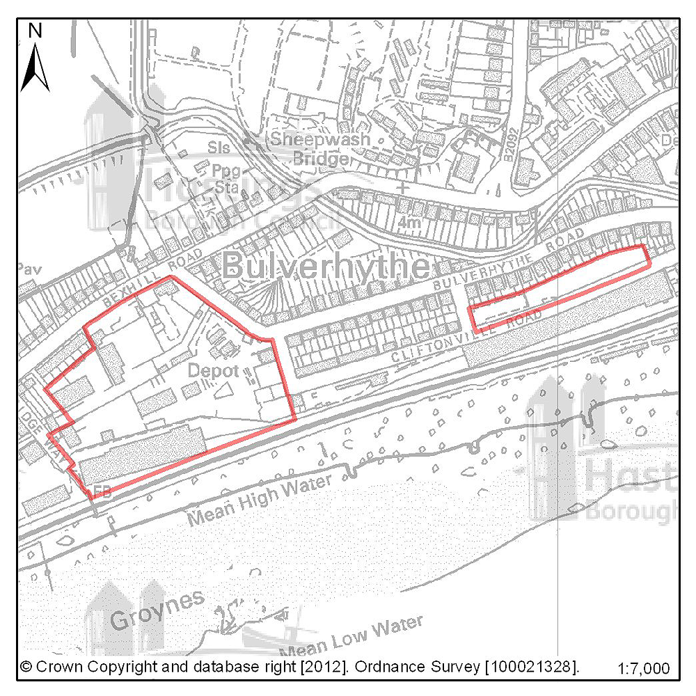
Figure 29: Location plan for B01
Site address: Bulverhythe Development Area
Suggested use: Residential
Planning status: None
Area: 4.28ha
Possible net capacity: 100
Assessment summary: There are 2 parcels of land that may be available for redevelopment during the Plan period. Both parcels are low lying; relatively flat and protected from tidal flooding by a series of sea defences. Some land assembly and relocation of existing uses may be required. The 2 parcels of land may be suitable for a mixed use redevelopment, including commercial and residential uses. Together, both parcels could accommodate 100 dwellings units with commercial floorspace. Our preference would be to allocate both parcels for mixed development comprising residential and commercial development.
Previously your comments were:
- Not suitable for high density development
- Flood risk
- Could be considered for allotments
(8) Site reference: B13

Figure 30: Location plan for B13
Site address: Cinque Ports Way, Stamco timber & TA Centre
Suggested use: Residential
Planning status: None
Area: 0.89ha
Possible net capacity: 54
Assessment summary: This area has redevelopment potential for a mix of uses including residential. The site is potentially part of the West Marina redevelopment - an area of vacant and under used land the regeneration of which has been a long term objective of the Council. The West Marina Masterplan indicated that this site could support 54 housing units as part of a mix of commercial and residential units
Previously your comments were:
- The site should be allocated for mixed use
- Primarily retail to form the commercial core of the West Marina regeneration area
- Flood risk?
- More suited to leisure/cultural uses to compliment surrounding uses
- Sea level rises need to be considered
- Traffic problems
- Indicative capacity too high
(2) Site reference: B14

Figure 31: Location plan for B14
Site address: Former Hastings College, St Saviours Road
Suggested use: Residential
Planning status: Full Planning permission
Area: 1.05ha
Possible net capacity: 44
Assessment summary: This site has full planning permission for residential development. Our preference would be to allocate this site for residential development with an indicative capacity of 44 units.
Previously your comments were:
- Suitable for low rise development, support the delivery of mix of housing in this sustainable location
- Indicative capacity too high
(10) Site reference: N02

Figure 32: Location plan for N02
Site address: Land South of Crowhurst Road
Suggested use: Residential
Planning status: None
Area: 0.84ha
Possible net capacity: 20
Assessment summary: This greenfield site is raised and mostly level, it could be suitable for development including residential development. The site is heavily screened by a strong hedge & tree boundary and lies above the B2092 (Queensway). This site is relatively isolated in terms of access to local facilities and higher density development would not therefore be appropriate. The site is currently outside of the built-up area boundary which normally means there is a presumption against residential development. The Development Management Plan offers an opportunity to reappraise the built-up area boundary at this location, however any amendment to the built-up would need to be robustly justified. Based on density of 25 dwellings per hectare this site has a potential capacity of c.20 units. The site is put forward for comment and reaction. The Council is not making a recommendation at this time.
(10) Site reference: N03

Figure 33: Location plan for N03
Site address: The Grove School
Suggested use: Residential
Planning status: None
Area: 9.4ha
Possible net capacity: 240
Assessment summary: Given the changes currently taking place in secondary education in Hastings, it is possible the site will become available for development during the Plan period to 2028. The site is included in the consultation for this reason. Should the school site become surplus to requirement, our preferred use would be for housing. However, this is a large site which would require a full planning assessment if it were to become available for development during the Local Plan period. The total site area included the woodland in the south-west corner of the site is 9.4Ha. It is assumed the wooded area would not form part of any redevelopment. If redevelop included the school playing fields the total site area available for development is 8.1Ha. If a density of 30 dwellings per hectare is assumed the site could be capable of delivering c.240 units. The capacity would be significantly less if the playing fields were retained and/or other constraints were identified. The site is put forward for comment and reaction. The Council is not making a recommendation at this time.
St Helen’s (Planning Focus Area 4)
Table 7: Possible net number of dwellings on sites in Focus Area 4
| Site reference | Address | Possible net number of dwellings | Area (ha) | Planning status |
|---|---|---|---|---|
| A28 | Land at Osborne House, The Ridge | 66 | 2.95 | Outline planning permission subject to legal agreement |
| D40 | 191 The Ridge | 7 | 0.15 | Outline planning permission subject to legal agreement |
| D41 | 195 The Ridge | 14 | 0.26 | Outline planning permission subject to legal agreement |
| C02 | Mount Denys, Pinehill & Ridgeway | 31 | 0.64 | None |
| A47 | Rear of Linley Drive | 15 | 0.32 | Allocated in Hastings Local Plan 2004 |
| A21 | Hurst Court, The Ridge | 42 | 1.44 | Allocated in Hastings Local Plan 2004 |
| C03 | Old Roar House, Old Roar Road | 14 | 0.84 | Outline planning permission – see proforma in Planning Focus Area 1 |
| N04 | Land adjacent to Sandrock Park, The Ridge | 2.74 | None |
Table 8: Potential gross employment floorspace on sites in Focus Area 4
| Site reference | Address | Potential gross floorspace (m2) | Area (ha) | Planning status |
|---|---|---|---|---|
| None | ||||
Planning Focus Area 4
(10) Site reference: A28
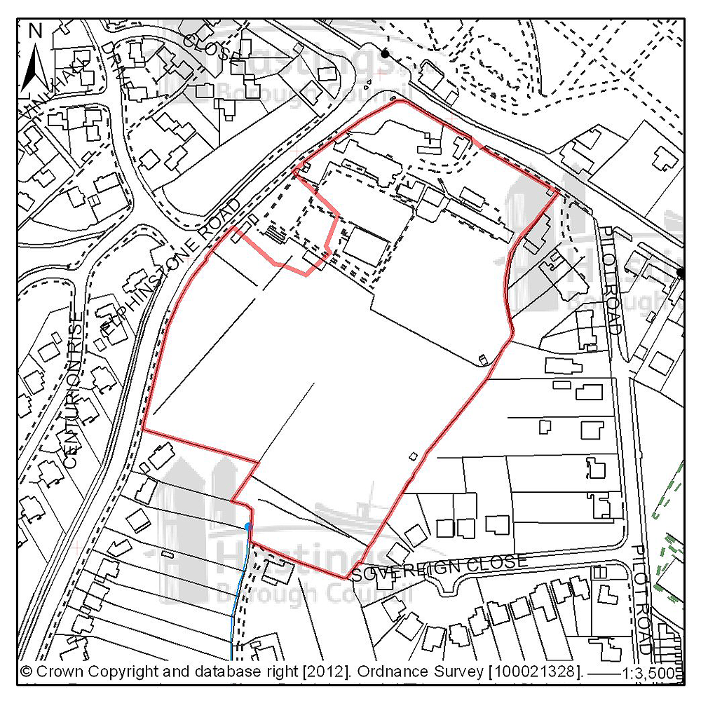
Figure 34: Location plan for A28
Site address: Land at Osborne House, The Ridge
Suggested use: Residential
Planning status: Outline planning permission subject to a legal agreement
Area: 2.95ha
Possible net capacity: 55
Assessment summary: This site is allocated for residential development in the existing Local Plan. A planning proposal involving the redevelopment of the site has been approved subject to a legal agreement. Our preference would be to continue to allocate this site for mixed use including residential development with an indicative site capacity of 55 units.
Previously your comments were:
None
(9) Site reference: D40
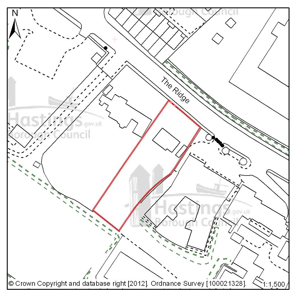
Figure 35: Location plan for D40
Site address: 191 The Ridge
Suggested use: Residential
Planning status: Outline planning permission subject to a legal agreement
Area: 0.15ha
Possible net capacity: 7
Assessment summary: The suitability of developing this site for housing has been established through an earlier resolution by the Planning Committee to approve a planning application subject to a legal agreement. Our preference would be to allocate this site for residential development with an indicative site capacity of 7 units.
Previously your comments were:
None
(6) Site reference: D41
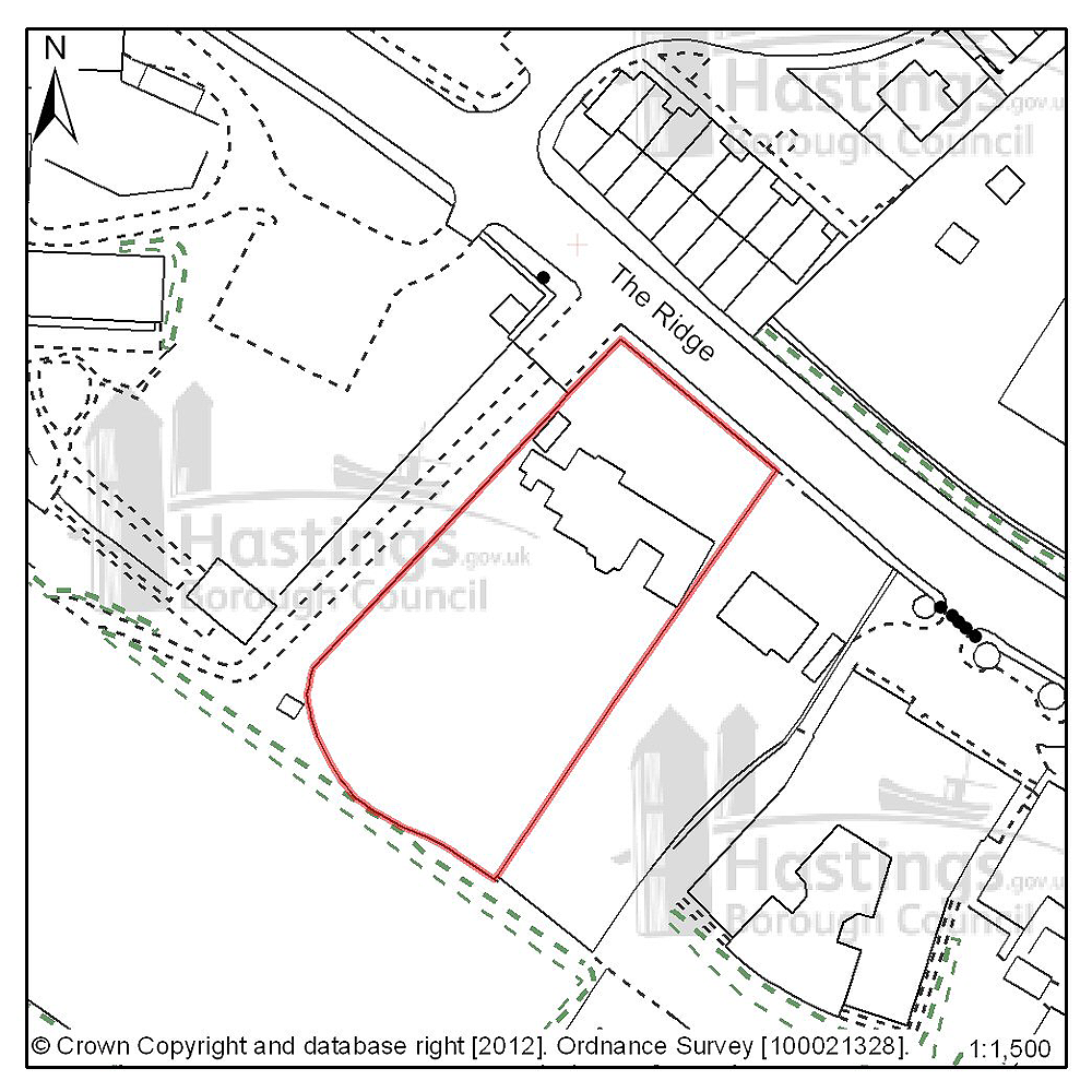
Figure 36: Location plan for D41
Site address: 195 The Ridge
Suggested use: Residential
Planning status: Outline planning permission subject to a legal agreement
Area: 0.26ha
Possible net capacity: 14
Assessment summary: The suitability of developing this site for housing has been established through a current outline planning permission. Our preference would be to allocate this site for residential development with an indicative capacity of 14 units.
Previously your comments were:
None
(10) Site reference: C02
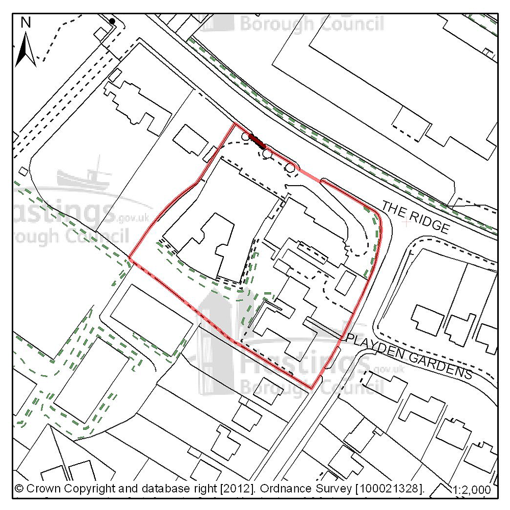
Figure 37: Location plan for C02
Site address: Mount Denys, Pinehill & Ridgeway
Suggested use: Residential
Planning status: None
Area: 0.64ha
Possible net capacity: 31
Assessment summary: These buildings are currently used by East Sussex County Council Social Services, and may become vacant during the Plan period, when the services provided here are transferred to a new location and purpose built development further along The Ridge. Should this site be vacated, our preference would be for the site to be redeveloped for residential development. Given the existing character of the surrounding area, the site is suitable for a high density development with a suggested capacity of c.30 dwellings.
Previously your comments were:
None
(12) Site reference: A47
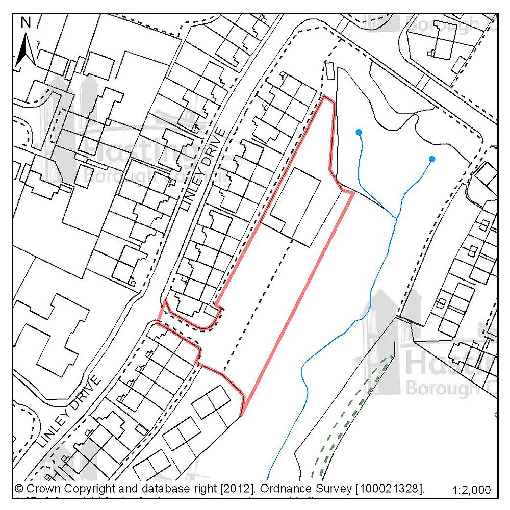
Figure 38: Location plan for A47
Site address: Rear of Linley Drive
Suggested use: Residential
Planning status: Allocated in the Hastings Local Plan 2004
Area: 0.32ha
Possible net capacity: 15
Assessment summary: This site is allocated for residential development in the existing Local Plan. The site remains suitable for residential development. Our preference is to continue allocate this site for residential development with an indicative capacity of 15 units.
Previously your comments were:
None
(12) Site reference: A21
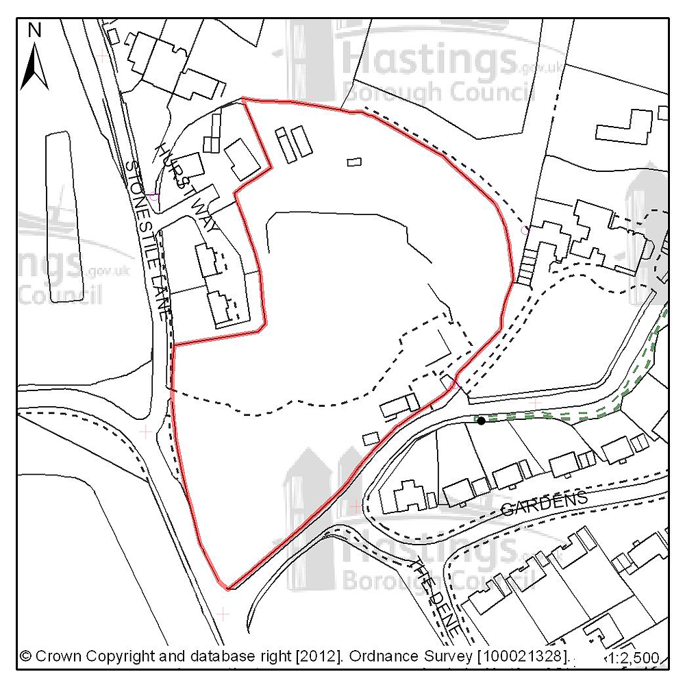
Figure 39: Location plan for A21
Site address: Hurst Court, The Ridge
Suggested use: Residential
Planning status: Allocated in the Hastings Local Plan 2004
Area: 1.44ha
Possible net capacity: 40
Assessment summary: This site is allocated in the existing Local Plan for residential development. Wildlife and tree cover are likely to affect the developable area of the site. Providing these important issues can satisfactorily addressed, the site remains suitable for residential development. Our preference is to continue to allocate this site for housing development with an indicative capacity of c.40 units.
Previously your comments were:
None
(42) Site reference: N04
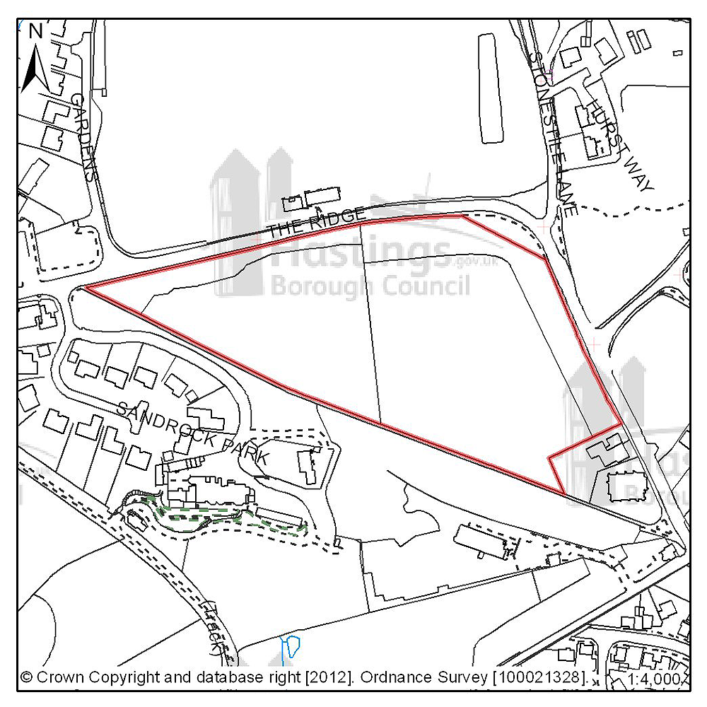
Figure 40: Location plan for N04
Site address: Land adjacent to Sandrock Park, The Ridge
Suggested use: Residential
Planning status: Part allocated in the Hastings Local Plan 2004 (playing field)
Area: 2.74ha
Possible net capacity: 80
Assessment summary: This flat triangular site lies directly to the south of The Ridge. The western part of the site is unused and the eastern part is a playing field which is under used. There is a tree screen along the frontage with The Ridge. The existing boundary trees are the most significant landscape characteristic of the area, and would need to be managed as part of any development. Retention & management of the existing trees and hedges would be the primary means of mitigation. However, a new access would be required at the western end of the site which is likely to take all of the tree screening fronting The Ridge. The site is currently outside of the built-up area boundary which normally means there is a presumption against residential development. The Development Management Plan offers an opportunity to reappraise the built-up area boundary at this location, however any amendment to the built-up boundary would need to be robustly justified. Although it is on the edge of the urban area, the site is reasonably to close facilities. If a density of 30 dwellings per hectare is assumed the site is capable of delivering c.80 dwellings. The site is put forward for comment and reaction. The Council is not making a recommendation at this time.
Silverhill & Alexandra Park (Planning Focus Area 5)
Table 9: Possible net number of dwellings on sites in Focus Area 5
| Site reference | Address | Possible net number of dwellings | Area (ha) | Planning status |
|---|---|---|---|---|
| C04 | Horntye Park | 109 | 0.87 | Full planning permission subject to legal agreement |
| A19 | 12-19 Braybrooke Terrace | 25 | 0.23 | Part allocated in Hastings Local Plan 2004 (lapsed planning permission) |
| A33 | Hollingsworth Garage, Braybrooke Road | 56 | 0.40 | Allocated in Hastings Local Plan 2004 |
| D20 | The Langham Hotel, 16 Elphinstone Road | 9 | 0.05 | Full planning permission |
| D30 | Silver Springs Medical Practice, Beaufort Road | 9 | 0.12 | Outline planning permission |
| D32 | 347-349 London Road | 20 | 0.15 | Lapsed planning permission |
Table 10: Potential gross employment floorspace on sites in Focus Area 5
| Site reference | Address | Potential gross floorspace (m2) | Area (ha) | Planning status |
|---|---|---|---|---|
| None | ||||
Planning Focus Area 5
(8) Site reference: C04
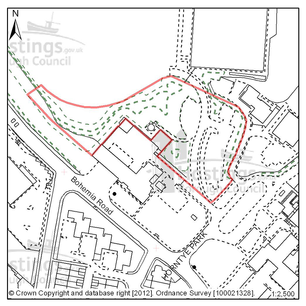
Figure 41: Location plan for C04
Site address: Horntye Park
Suggested use: Residential
Planning status: Full planning permission subject to a legal agreement
Area: 0.87ha
Possible net capacity: 109
Assessment summary: The suitability of developing this site for housing has been established through an earlier resolution to approve a planning application subject to a legal agreement. Our preference would be to allocate this site for residential development with an indicative site capacity of 109 units.
Previously your comments were:
- Over development
- Grassy area around law courts is useless for biodiversity & could be allocated for new allotments or community gardening
(8) Site reference: A19
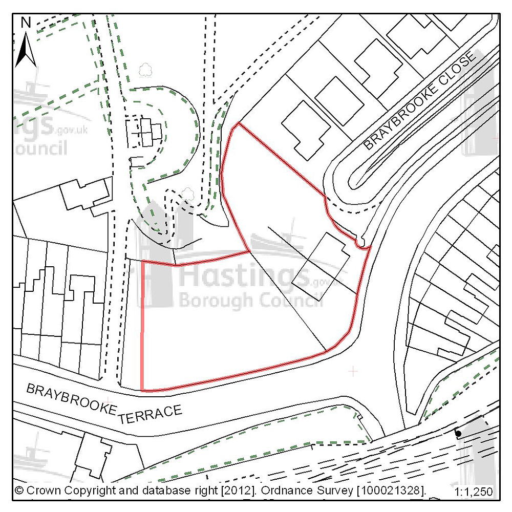
Figure 42: Location plan for A19
Site address: 12-19 Braybrooke Terrace
Suggested use: Residential
Planning status: Part allocated in the Hastings Local Plan 2004 (lapsed planning permission)
Area: 0.23ha
Possible net capacity: 25
Assessment summary: This site is allocated for residential development in the existing Local Plan. An earlier planning permission has now lapsed, and there is now the potential to increase the site area and it is likely to be able to accommodate more units than it was originally allocated for. Our preference is to continue to allocate this site plus the additional land for housing with an indicative capacity of 25 units.
Previously your comments were:
- Houses not flats
- Need a commitment to facilities for voluntary & community groups in the town centre
(9) Site reference: A33
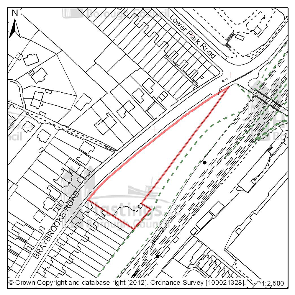
Figure 43: Location plan for A33
Site address: Hollingsworth Garage, Braybrooke Road
Suggested use: Residential
Planning status: Allocated in the Hastings Local Plan 2004
Area: 0.40ha
Possible net capacity: 56
Assessment summary: This site is allocated for residential development in the existing Local Plan. The site remains suitable for residential development. Our preference is to continue allocate this site for residential development with an indicative capacity of 56 units.
Previously your comments were:
- Not suitable for high density development
- Gross over development
(4) Site reference: D20

Figure 44: Location plan for D20
Site address: The Langham Hotel, 16 Elphinstone Road
Suggested use: Residential
Planning status: Full planning permission
Area: 0.05ha
Possible net capacity: 9
Assessment summary: This site has full planning permission for residential development. Our preference would be to allocate this site for residential development with an indicative capacity of 9 units.
Previously your comments were:
None
(2) Site reference: D30
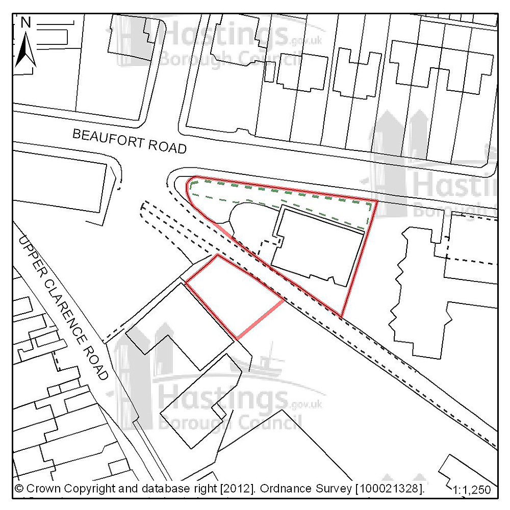
Figure 45: Location plan for D30
Site address: Silver Springs Medical Practice, Beaufort Road
Suggested use: Residential
Planning status: Outline planning permission
Area: 0.12ha
Possible net capacity: 9
Assessment summary: The suitability of developing this site for housing has been established through a current outline planning permission. Our preference would be to allocate this site for residential development with an indicative capacity of 9 units.
Previously your comments were:
None
(4) Site reference: D32

Figure 46: Location plan for D32
Site address: 347-349 London Road
Suggested use: Residential
Planning status: Lapsed planning permission
Area: 0.15ha
Possible net capacity: 22
Assessment summary: Although planning permission for residential development has recently lapsed on this site, the site's suitability for residential development has been established. Our preference would be to allocate this site for residential development with an indicative capacity of 22 units.
Previously your comments were:
None
Maze Hill & Burtons’ St Leonards (Planning Focus Area 6)
Table 11: Possible net number of dwellings on sites in Focus Area 6
| Site reference | Address | Possible net number of dwellings | Area (ha) | Planning status |
|---|---|---|---|---|
| D18 | 49-52 Caves Road | 6 | 0.06 | Lapsed planning permission |
| D51 | 36-40 Caves Road | 6 | 0.04 | Full planning permission |
| D21 | 27 Dane Road | 11 | 0.14 | Full planning permission |
| D53 | 37 Charles Road West, Filsham Nurseries | 9 | 0.26 | Outline planning permission subject to legal agreement |
| A32 | Gambier House, West Hill Road | 15 | 0.23 | Allocated in Hastings Local Plan 2004 |
| B24 | West Hill Road Reservoir | 14 | 0.19 | Full planning permission |
| B02 | Former Hastings College, Archery Road | 100 | 2.22 | Current application undetermined |
Table 12: Potential gross employment floorspace on sites in Focus Area 6
| Site reference | Address | Potential gross floorspace (m2) | Area (ha) | Planning status |
|---|---|---|---|---|
| None | ||||
Planning Focus Area 6

(1) Site reference: D18

Figure 47: Location plan for D18
Site address: 49-52 Caves Road
Suggested use: Residential
Planning status: Lapsed planning permission
Area: 0.06ha
Possible net capacity: 6
Assessment summary: Although planning permission for residential development has recently lapsed on this site, the site's suitability for residential development has been established. Our preference would be to allocate this site for residential development with an indicative capacity of 6 units.
Previously your comments were:
None
(1) Site reference: D51
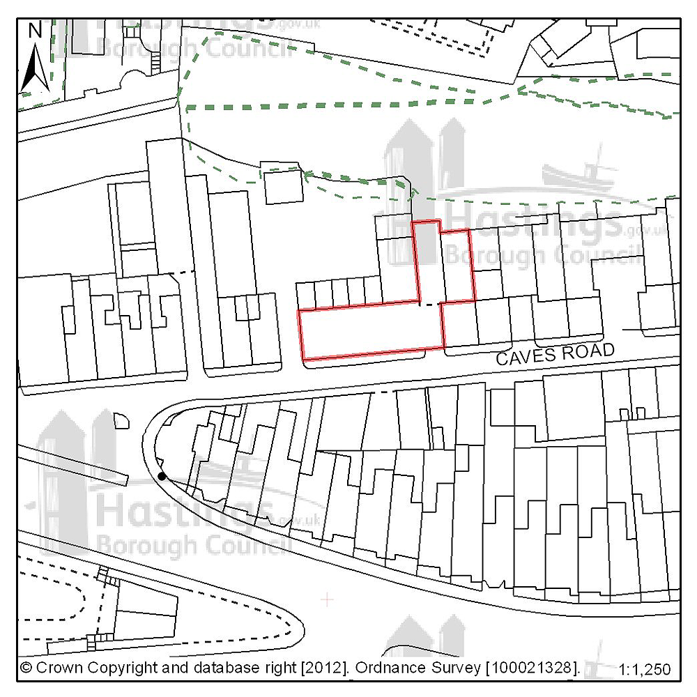
Figure 48: Location plan for D51
Site address: 36-40 Caves Road
Suggested use: Residential
Planning status: Full planning permission
Area: 0.04ha
Possible net capacity: 6
Assessment summary: This site has full planning permission for residential development. Our preference would be to allocate this site for residential development with an indicative capacity of 6 units.
Previously your comments were:
None
(1) Site reference: D21
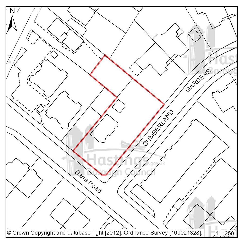
Figure 49: Location plan for D21
Site address: 27 Dane Road
Suggested use: Residential
Planning status: Full planning permission
Area: 0.14ha
Possible net capacity: 11
Assessment summary: This site has full planning permission for residential development. Our preference would be to allocate this site for residential development with an indicative capacity of 11 units.
Previously your comments were:
None
(1) Site reference: D53
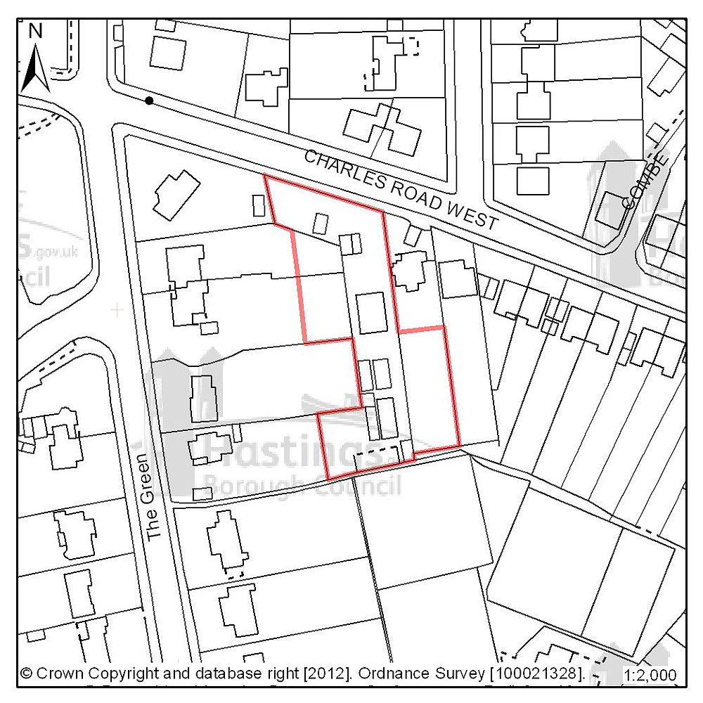
Figure 50: Location plan for D53
Site address: 37 Charles Road West (Filsham Nurseries)
Suggested use: Residential
Planning status: Outline planning permission subject to a legal agreement
Area: 0.26ha
Possible net capacity: 9
Assessment summary: The suitability of developing this site for housing has been established through an earlier resolution by the Planning Committee to approve a planning application subject to a legal agreement. Our preference would be to allocate this site for residential development with an indicative site capacity of 9 units.
Previously your comments were:
None
(2) Site reference: A32
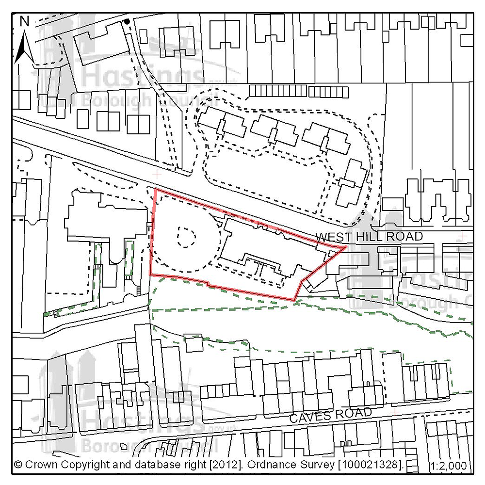
Figure 51: Location plan for A32
Site address: Gambier House, West Hill Road
Suggested use: Residential
Planning status: Allocated in the Hastings Local Plan 2004
Area: 0.23ha
Possible net capacity: 15
Assessment summary: This site is allocated for residential development in the existing Local Plan. The existing buildings are to be vacated by the current occupier - the NHS. Marketing as to the site's availability took place in July 2011. The site is located within a Conservation Area. Our preference is to continue to allocate this site for residential development with an indicative capacity of 15 units.
Previously your comments were:
None
(2) Site reference: B24
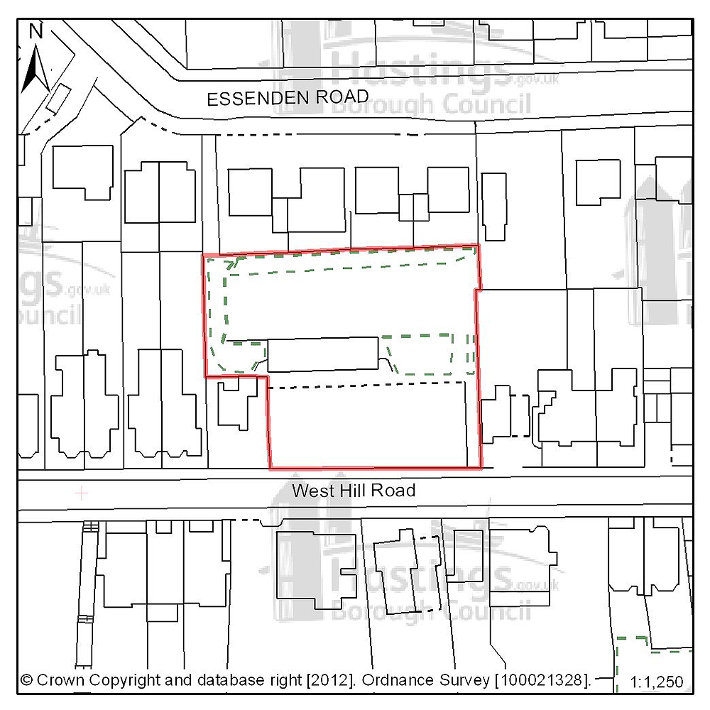
Figure 52: Location plan for B24
Site address: West Hill Road Reservoir
Suggested use: Residential
Planning status: Full planning permission
Area: 0.19ha
Possible net capacity: 14
Assessment summary: This site has full planning permission for residential development. Our preference would be to allocate this site for residential development with an indicative capacity of 14 units
Previously your comments were:
- James Burton history that should be preserved
(15) Site reference: B02
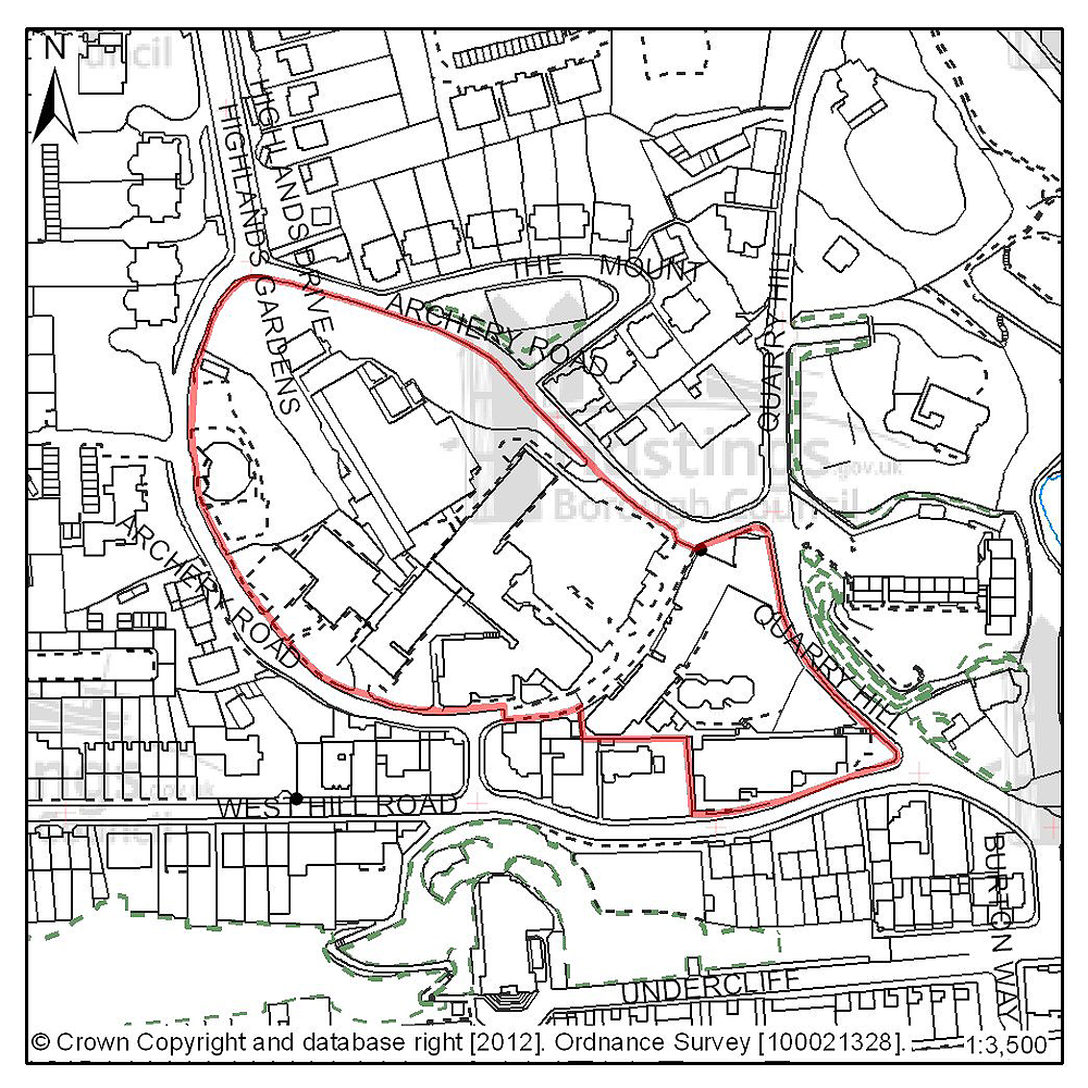
Figure 53: Location plan for B02
Site address: Former Hastings College, Archery Road
Suggested use: Residential
Planning status: Planning application submitted – currently undetermined
Area: 2.22ha
Possible net capacity: 155
Assessment summary: Owing to the relocation of the former occupier, this site is now available for redevelopment. As a brownfield site in an established residential area, our preference is for the site to be redeveloped for residential use. Redevelopment will remove the existing redundant buildings and will provide the opportunity to convert the listed building and introduce a new use for the remainder of the site. In terms of the volume and form of future development, key factors that need to be taken into account in any redevelopment proposals is the relationship to the terrace of listed buildings within the site and the site's location within St Leonard's West Conservation Area. The current proposals for the site which are under consideration are for the development of 155 residential units.
Previously your comments were:
- Support delivery of a mix of housing
- Too dense, over development
- Within a conservation area
- Current proposals not in keeping with existing
- Needs sensitive development
- Developments should include provision of allotments or community gardening
- Flats not wanted
- Reallocate all or part as green/open space
Central St Leonards & Bohemia (Planning Focus Area 7)
Table 13: Possible net number of dwellings on sites in Focus Area 7
| Site reference | Address | Possible net number of dwellings | Area (ha) | Planning status | ||||
|---|---|---|---|---|---|---|---|---|
| A20 | Taxi office/B.R. Social Club, St Johns Road | 30 | 0.12 | Allocated in Hastings Local Plan 2004 | ||||
| B06 | Crystal Square | 60 | 0.47 | None | ||||
| B12 | 1-3 Chapel Park Road | 27 | 0.13 | Full planning permission | ||||
| B31 | College of Holy Child Jesus, Magdalen Road | 32 | 4.91 | Planning application undetermined | ||||
| D08 | Sorting Office site, Kings Road | 8 | 0.05 | Full planning permission | ||||
| D14 | 4-5 Stockleigh Road | 12 | 0.03 | Full planning permission | ||||
Table 14: Potential gross employment floorspace on sites in Focus Area 7
| Site reference | Address | Potential gross floorspace (m2) | Area (ha) | Planning status |
|---|---|---|---|---|
| None | ||||
Planning Focus Area 7
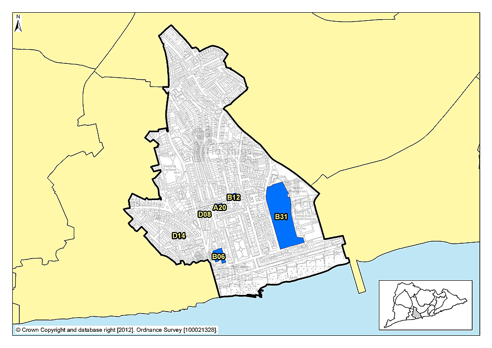
Insert focus area map for Central St Leonards and Bohemia Figure PFA7
(13) Site reference: A20

Figure 54: Location plan for A20
Site address: Taxi Office/B.R. Social Club, St Johns Road
Suggested use: Residential
Planning status: Allocated in the Hastings Local Plan 2004
Area: 0.12ha
Possible net capacity: 30
Assessment summary: This site is allocated in the existing Local Plan for mixed use development, with commercial uses on the ground floor and residential above. Our preference is to continue to allocate this site for housing with an indicative capacity of 30 units.
Previously your comments were:
None
(10) Site reference: B06
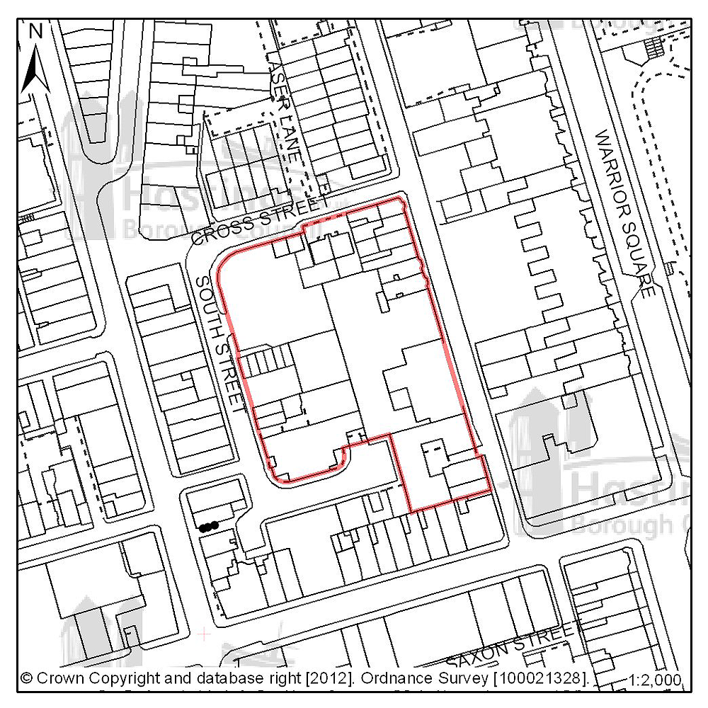
Figure 55: Location plan for B06
Site address: Crystal Square and Western Road
Suggested use: Mixed use
Planning status: None
Area: 0.47ha
Possible net capacity: 60
Assessment summary: This site, which is centred on Crystal Square car park, offers the largest potential regeneration opportunity in the locality and was included within the Central St Leonards Regeneration Framework. The site is capable of accommodating a mixed use development based on housing and retail with the possible inclusion of business and leisure uses. Amongst other factors, the volume and form of development will need to take into account the site's location with a Conservation Area. Because land acquisition would be involved in the development of this site, its development is likely to be in the later part of the Plan period. A capacity of 60 residential units is suggested as part of a mixed use scheme.
Previously your comments were:
- Area already densely developed
- Finance should be sought for multi-storey car park
- Question multi-storey flatted development – are flats needed here?
- Loss of car parking area
- The loss of the Adams & Jarrett warehouse – the shop could not operate without it
(2) Site reference: B12
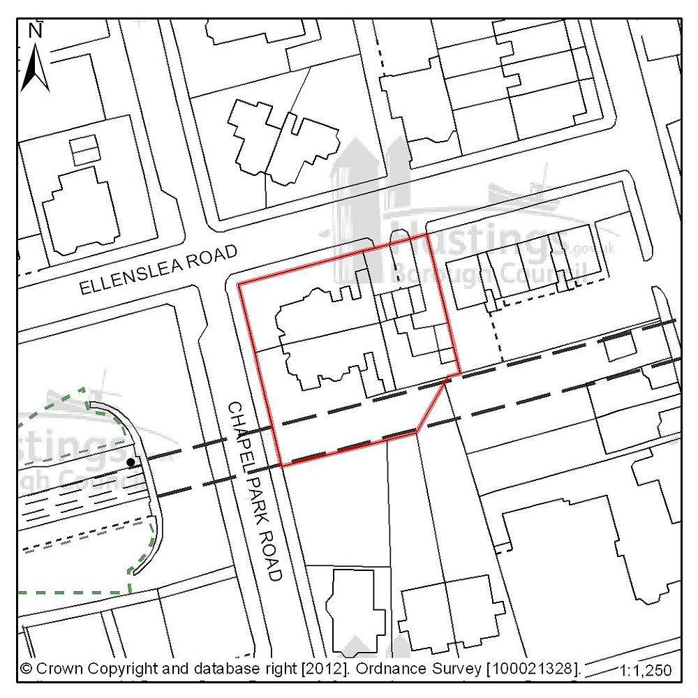
Figure 56: Location plan for B12
Site address: 1-3 Chapel Park Road
Suggested use: Residential
Planning status: Full planning permission
Area: 0.13ha
Possible net capacity: 27
Assessment summary: This site has full planning permission for residential development. Our preference would be to allocate this site for residential development with an indicative capacity of 27 units.
Previously your comments were:
None
(31) Site reference: B31
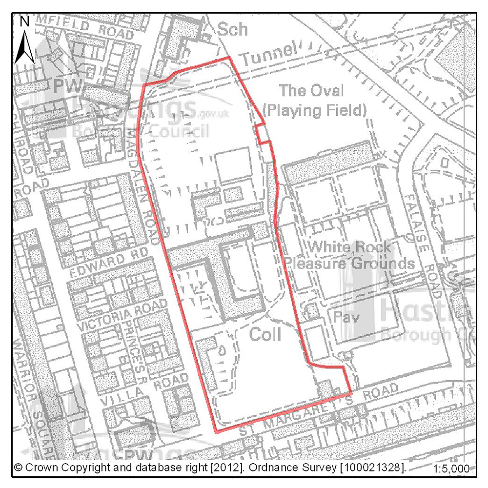
Figure 57: Location plan for B31
Site address: College of Holy Child Jesus, Magdalen Road
Suggested use: Residential
Planning status: Planning application submitted currently undetermined
Area: 4.91ha
Possible net capacity:
Assessment summary: The current owner may vacate and dispose of this site, which over recent years has used as a summer language school. The site includes a number of listed buildings and allowing these buildings to become vacant and unused in the future represents a wasted resource and a concern to the Council. A viable use needs to be found for these buildings some of which are deteriorating. In an established residential area, our preference would be to see as many of the historically important buildings as possible converted and re-used. It is important that any development of the site will need to be linked to securing the restoration and long term future of the historic buildings potentially through an enabling development. Current proposals for the site are under consideration, they are for the restoration & conversion of the Gothic Building, 'Gate Lodge' & former 'Convent Building' to residential use comprising 32 dwellings & associated parking areas and the demolition of the west wing & laundry building. The proposals also include development of 165 new residential units with associated parking areas, giving a total net residential build 197, and also include the restoration of the Chapel, landscaping and the creation of new access. An amended scheme is likely to be submitted by February 2012 which will be the subject of further public consultation before the application is determined.
Previously your comments were:
- Building blocks of flats with parking spaces neither preserves or enhances area
- Why is this no longer greenspace?
- Development will ruin the Conservation Area
- Mini university campus should be here
- This should all be greenspace
- Too many flats without gardens
- Some land should be given over to allotments
- Higher indicative capacity at public exhibition
- Question the delivery of 160 units here with listed building and Conservation Area constraints
- Breach of para 2.7 of HBC’s own designation
- Inappropriate use of site
- Take care not to destroy
- Over development must be avoided on this site
(2) Site reference: D08
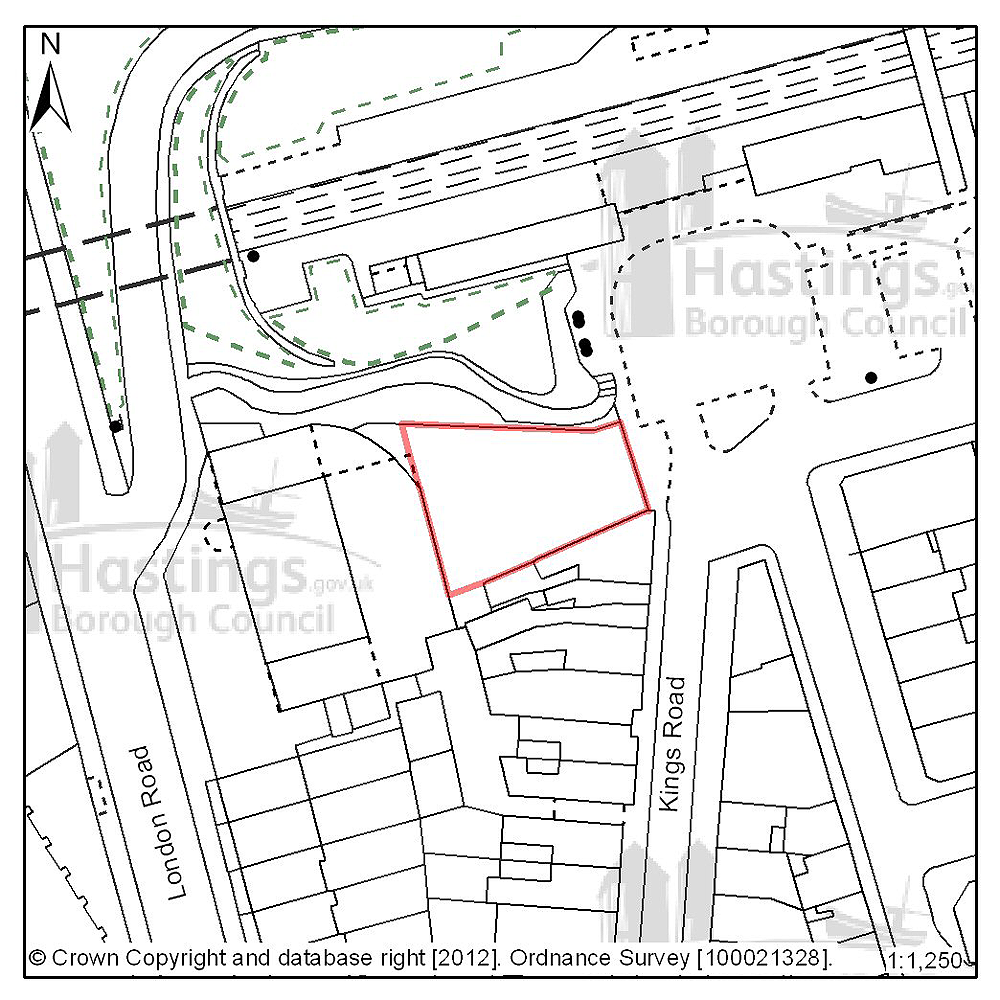
Figure 58: Location plan for D08
Site address: Sorting Office site, Kings Road
Suggested use: Residential
Planning status: Full planning permission
Area: 0.05ha
Possible net capacity: 8
Assessment summary: This site has full planning permission for residential development. Our preference would be to allocate this site for residential development with an indicative capacity of 8 units.
Previously your comments were:
None
(2) Site reference: D14
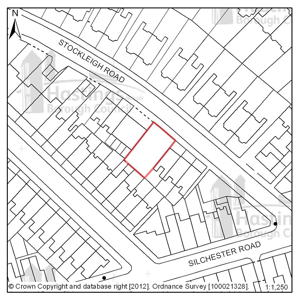
Figure 59: Location plan for D14
Site address: 4-5 Stockleigh Road
Suggested use: Residential
Planning status: Full planning permission
Area: 0.03ha
Possible net capacity: 12
Assessment summary: This site has full planning permission for residential development. Our preference would be to allocate this site for residential development with an indicative capacity of 12 units.
Previously your comments were:
None
Hastings Town Centre (Planning Focus Area 8)
Table 15: Possible net number of dwellings on sites in Focus Area 8
| Site reference | Address | Possible net number of dwellings | Area (ha) | Planning status | ||||
|---|---|---|---|---|---|---|---|---|
| A14 | Hastings Station Yard (part) | 27 | 0.44 | Full planning permission | ||||
| A15 | The Observer Building (part) | 39 | 0.07 | Full planning permission subject to legal agreement | ||||
| A43 | Cornwallis Street Car Park | 10 | 0.22 | Allocated in Hastings Local Plan 2004 | ||||
| C06 | Braybrooke House, Holmesdale Gardens | 8 | 0.09 | None | ||||
| C07 | Westwood House, Holmesdale Gardens | 8 | 0.43 | None | ||||
| D50 | 40 & 41 Wellington Square | 12 | 0.02 | Full planning permission | ||||
| D52 | 36 & 37 Wellington Square | 12 | 0.02 | Full planning permission | ||||
Table 16: Potential gross employment floorspace on sites in Focus Area 8
| Site reference | Address | Potential gross floorspace (m2) | Area (ha) | Planning status |
|---|---|---|---|---|
| E12 | Priory Quarter, Havelock Road | 21,700 | 2.6 | New allocation |
Planning Focus Area 8
(7) Site reference: A14

Figure 60: Location plan for A14
Site address: Hastings Station Yard (part)
Suggested use: Mixed use
Planning status: Full planning permission
Area: 0.44ha
Possible net capacity: 103
Assessment summary: This site majority of this site has already been redevelopment educational and health care purposes and includes a small retail element. Part of the site is yet to be redeveloped and has planning permission for 103 units. This remaining part of the site continues to be suitable for residential use but may also be suited to mixed use scheme including residential. Our preference is to continue to allocate this site for mixed development with an indicative capacity of 103 units for residential use.
Previously your comments were:
None
(8) Site reference: A15
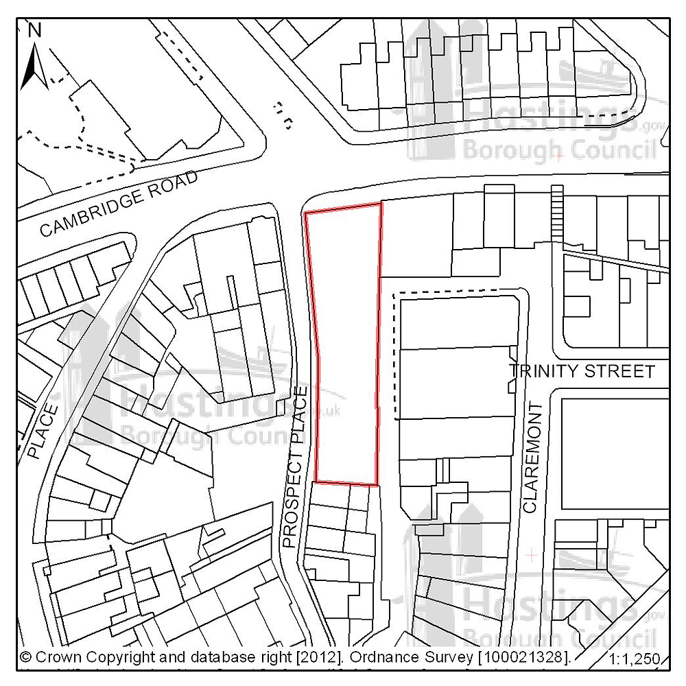
Figure 61: Location plan for A15
Site address: The Observer Building
Suggested use: Mixed use
Planning status: Full planning permission subject to a legal agreement
Area: 0.07ha
Possible net capacity: 39
Assessment summary: This vacant multi-storey building is allocated for mixed use development including residential use in the existing Local Plan. A planning proposal involving the redevelopment of the site has been approved subject to a legal agreement. Our preference would be to continue to allocate this site for mixed use including residential development with an indicative site capacity of 39 units.
Previously your comments were:
None
(3) Site reference: A43
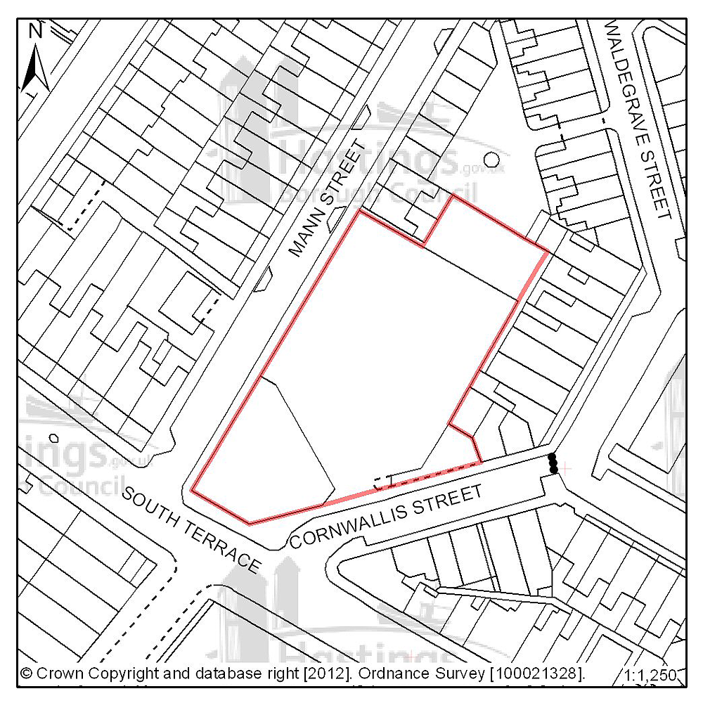
Figure 62: Location plan for A43
Site address: Cornwallis Street car park
Suggested use: Residential
Planning status: Allocated in the Hastings Local Plan 2004
Area: 0.22ha
Possible net capacity: 10
Assessment summary: This site is allocated for residential development in the existing Local Plan. The site remains suitable for residential development. Our preference is to continue allocate this site for residential development with an indicative capacity of 10 units.
Previously your comments were:
- Incorporate green/open space/play area
- Over development
(4) Site reference: C06
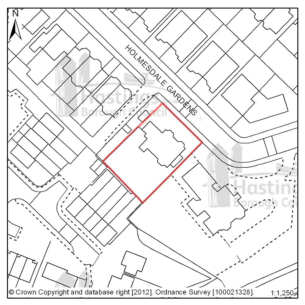
Figure 63: Location plan for C06
Site address: Braybrooke House, Holmesdale Gardens
Suggested use: Residential
Planning status: None
Area: 0.09ha
Possible net capacity: 8
Assessment summary: Braybrooke House and the neighbouring property of Westwood House are to be vacated by the current occupier - the NHS. Both properties were marketed in July 2011. Both properties are located within a Conservation Area. Braybrooke House is in close proximity to Hastings town centre and our preference is that the site should become residential in the future. An estimated capacity of 8 residential units is based on the conversion of the current building.
Previously your comments were:
- This should be a conversion
(3) Site reference: C07
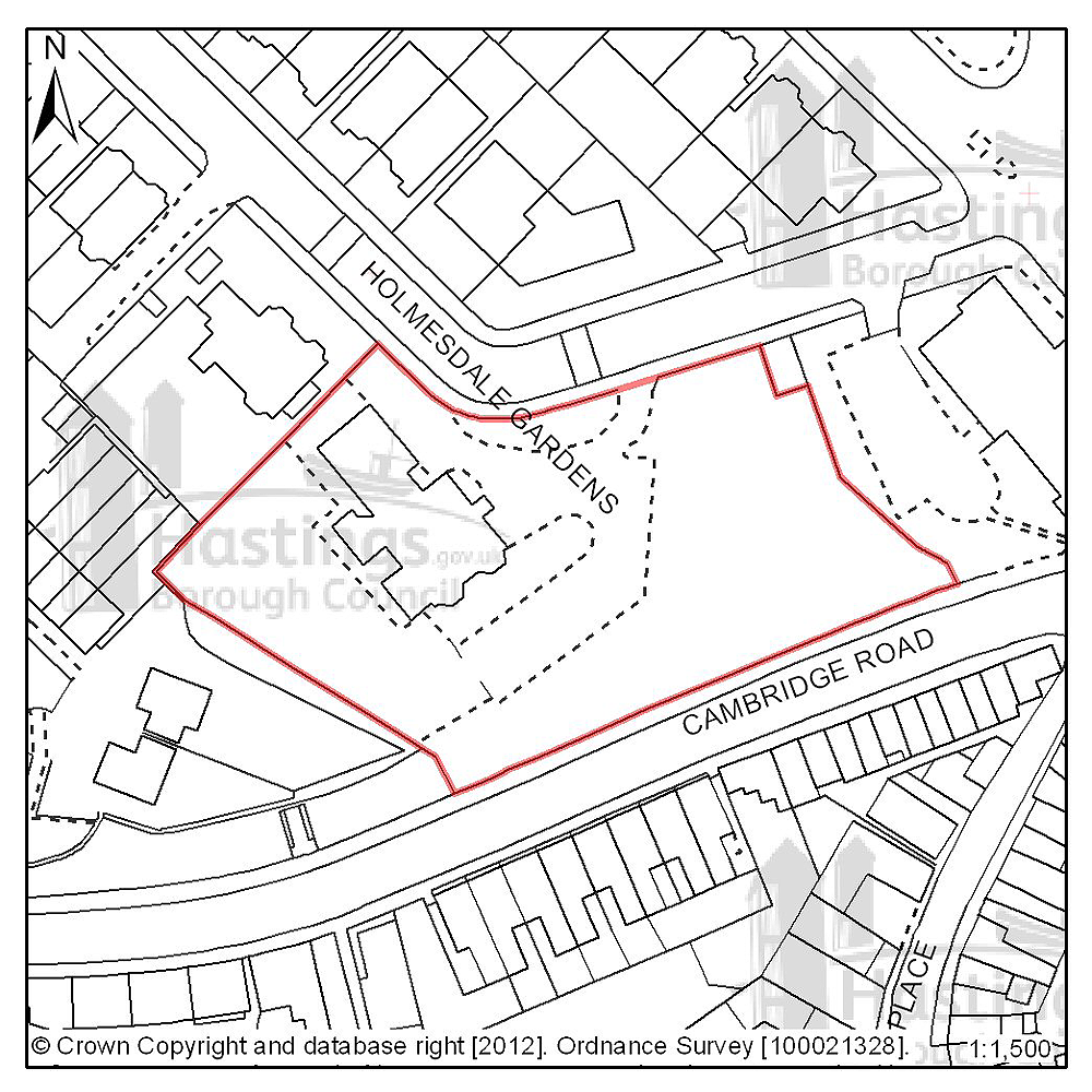
Figure 64: Location plan for C07
Site address: Westwood House, Holmesdale Gardens
Suggested use: Residential
Planning status: None
Area: 0.43ha
Possible net capacity: 8
Assessment summary: Westwood House and the neighbouring property of Braybrooke House are to be vacated by the current occupier - the NHS. Both properties were marketed in July 2011. Both properties are located within a Conservation Area. Westwood House is in close proximity to Hastings town centre and our preference is that the site should become residential in the future. An estimated capacity of 8 residential units is based on the conversion of the current building.
Previously your comments were:
- This should be a conversion
(2) Site reference: D50
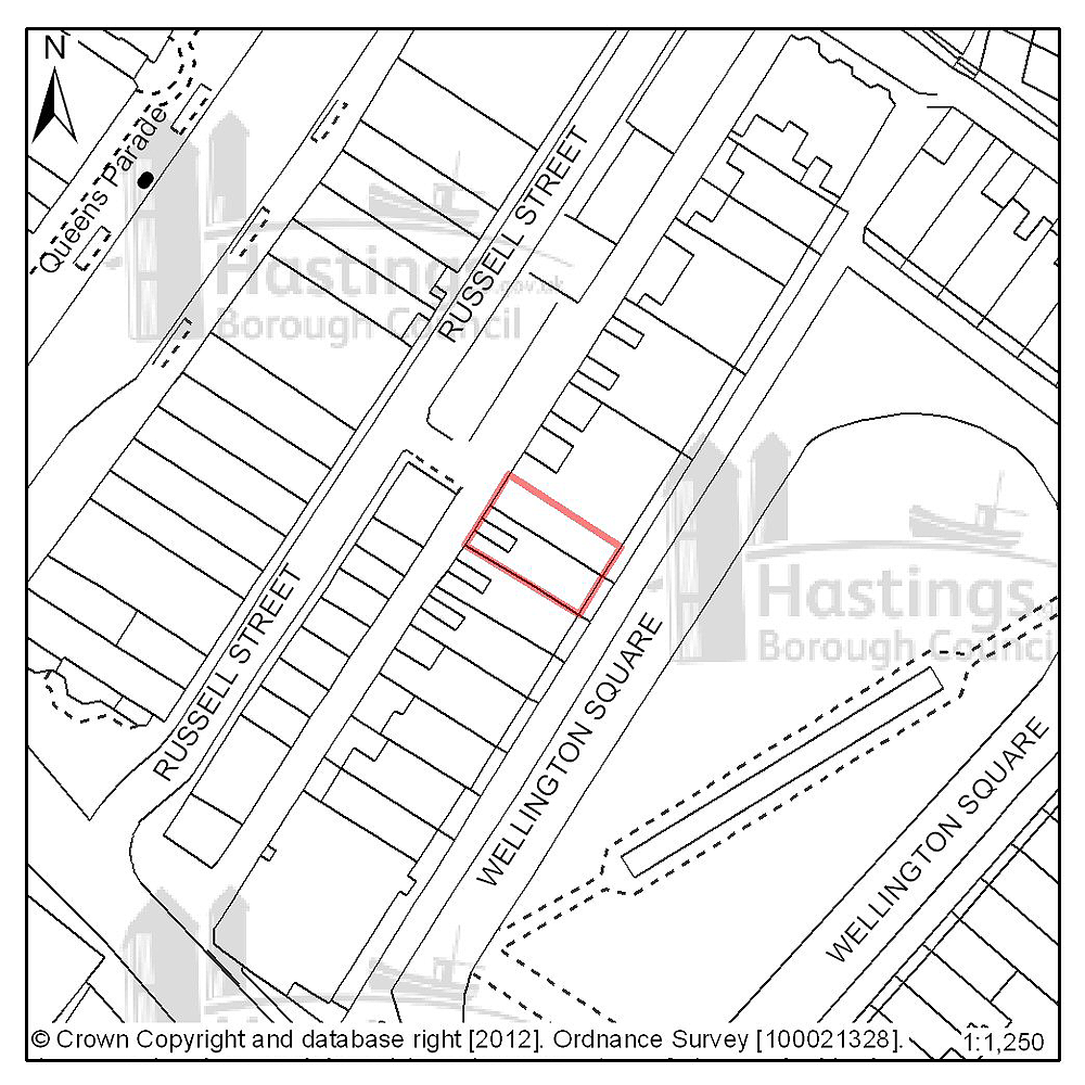
Figure 65: Location plan for D50
Site address: 40 & 41 Wellington Square
Suggested use: Residential
Planning status: Full planning permission
Area: 0.02ha
Possible net capacity: 12
Assessment summary: This site has full planning permission for residential development. Our preference would be to allocate this site for residential development with an indicative capacity of 12 units.
Previously your comments were:
(2) Site reference: D52
Figure 66: Location plan for D52
Site address: 36 & 37 Wellington Square
Suggested use: Residential
Planning status: Full planning permission
Area: 0.02ha
Possible net capacity: 12
Assessment summary: This site has full planning permission for residential development. Our preference would be to allocate this site for residential development with an indicative capacity of 12 units.
Previously your comments were:
None
(4) Site reference: E12
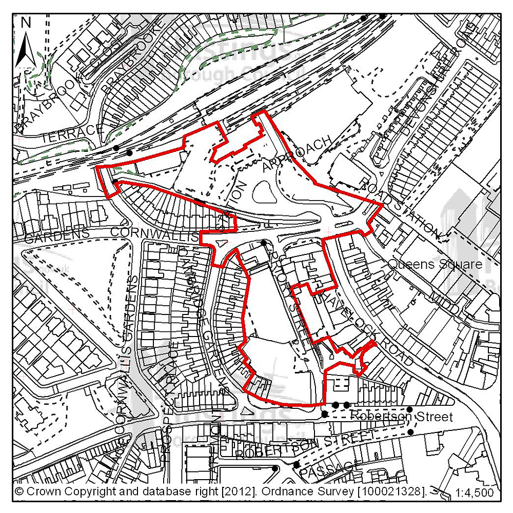
Figure 67: Location plan for E12
Site address: Priory Quarter, Havelock Road
Suggested use: Employment
Planning status: New allocation.
Area: 2.6ha
Possible net capacity: 21,700m2
Assessment summary: Although this site is not currently allocated in the adopted Hastings Local Plan 2004, it forms the remainder of what is known as Priory Quarter. An informal masterplanning framework was prepared in 2004/5 and followed up with an outline planning application in 2006/7 which the Council’s Planning Committee resolved to grant consent for (although it was subject to a section 106 agreement which has not been completed). The outline consent was for a large scale mixed development of offices, education, retail and leisure. A significant part of the proposal was subsequently implemented through separate planning consents and now forms the core of the town centre’s business and higher education quarter. All this was done as part of the major regeneration initiative led by the Hastings and Bexhill Task Force.
The proposed allocation represents the remaining part of Priory Quarter available for redevelopment and is expected to be implemented during the period of the new Plan.
Previously your comments were:
None
Old Town (Planning Focus Area 9)
Table 17: Possible net number of dwellings on sites in Focus Area 9
| Site reference | Address | Possible net number of dwellings | Area (ha) | Planning status |
|---|---|---|---|---|
| None | ||||
Table 18: Potential gross employment floorspace on sites in Focus Area 9
| Site reference | Address | Potential gross floorspace (m2) | Area (ha) | Planning status |
|---|---|---|---|---|
| None | ||||
Planning Focus Area 9
West Hill (Planning Focus Area 10)
Table 19: Possible net number of dwellings on sites in Focus Area 10
| Site reference | Address | Possible net number of dwellings | Area (ha) | Planning status |
|---|---|---|---|---|
| None | ||||
Table 20: Potential gross employment floorspace on sites in Focus Area 10
| Site reference | Address | Potential gross floorspace (m2) | Area (ha) | Planning status |
|---|---|---|---|---|
| None | ||||
Planning Focus Area 10
Hillcrest & Ore Valley (Planning Focus Area 11)
Table 21: Possible net number of dwellings on sites in Focus Area 11
| Site reference | Address | Possible net number of dwellings | Area (ha) | Planning status | ||||
|---|---|---|---|---|---|---|---|---|
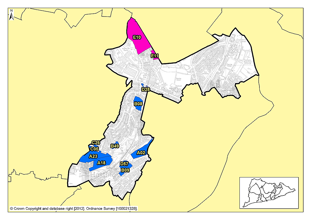
| A18 | Ore Valley | 50 | 2.35 | Allocated in the Hastings Local Plan 2004 | ||||
| A23 | Former Stills Factory (part) | 75 | 2.71 | Allocated in the Hastings Local Plan 2004 | ||||
| B08 | The Cheviots/Cotswold Close | 63 | 1.23 | Outline planning permission subject to legal agreement | ||||
| C05 | 2-20 (evens) Fellows Road | 17 | 0.27 | Outline planning permission subject to legal agreement | ||||
| C26 (was C09) | 5-15 (odds) Fellows Road | 12 | 0.10 | Outline planning permission subject to legal agreement | ||||
| B49 (was B34) | Upper Broomgrove Road | 12 | 0.29 | None | ||||
| D28 | 107 The Ridge (Simes & Sons) | 8 | 0.22 | Outline planning permission | ||||
| A02 | Mount Pleasant Hospital, Frederick Road | 40 | 1.84 | Allocated in the Hastings Local Plan 2004 | ||||
| B09 | 87-221 (odds) Farley Bank | 44 | 0.73 | Full planning permission subject to legal agreement | ||||
| D57 | Ore Business Park, Farley Bank | 37 | 0.70 | None | ||||
Table 22: Potential gross employment floorspace on sites in Focus Area 11
| Site reference | Address | Potential gross floorspace (m2) | Area (ha) | Planning status |
|---|---|---|---|---|
| E10 | Ivyhouse Lane, northern extension | 10,000 | 5.8 | Allocated in Hastings Local Plan 2004 |
| E11 | Land east of Burgess Road, Ivyhouse | 1,400 | 0.4 | Allocated in Hastings Local Plan 2004 |
Planning Focus Area 11
(5) Site reference: A18
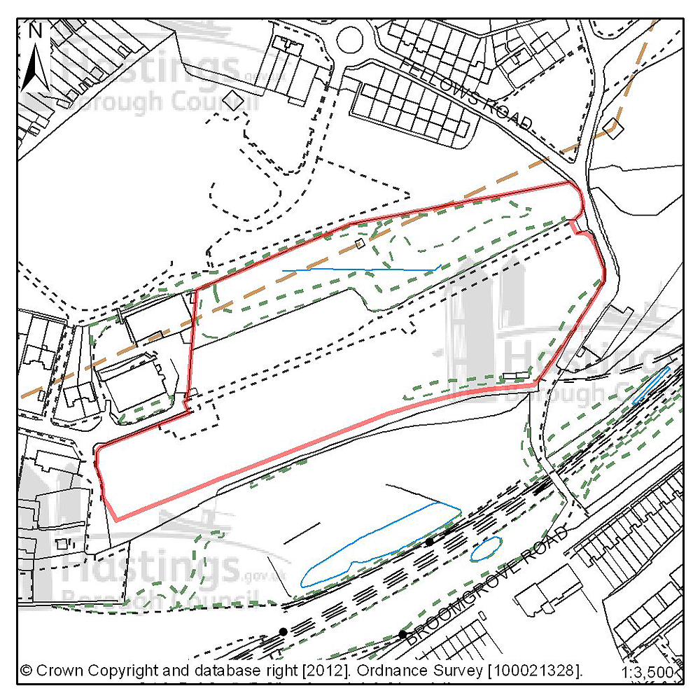
Figure 68: Location plan for A18
Site address: Ore Valley
Suggested use: Residential
Planning status: Allocated in the Hastings Local Plan 2004
Area: 2.35ha
Possible net capacity: 50
Assessment summary: This site is identified for residential development in the existing Local Plan. The site forms part of wider area of neglected and redundant land known as Ore Valley, the regeneration of which has been a long term objective of the Council. The introduction of new housing to this area is see as being both beneficial the immediate locality and the town as a whole. Ore Valley was to be redeveloped as part of the millennium community programme, and the original outline planning permission included housing, together with commercial, retail and higher education facilities. The first phase of this scheme is now nearing completion. Nationally the millennium communities’ programme has now ended. Our preference is to continue to allocate this site for residential development as part of the wider Ore Valley redevelopment area. The site has an indicative capacity of 50 units.
Previously your comments were:
None
(4) Site reference: A23
Figure 69: Location plan for A23
Site address: Former Stills Factory, Ore Valley
Suggested use: Residential
Planning status: Allocated in the Hastings Local Plan 2004
Area: 2.71ha
Possible net capacity: 75
Assessment summary: This site is identified for mixed development in the existing Local Plan. The site forms part of wider area of neglected and redundant land known as Ore Valley, the regeneration of which has been a long term objective of the Council. The introduction of new housing to this area is see as being both beneficial the immediate locality and the town as a whole. Ore Valley was to be redeveloped as part of the millennium community programme, and the original outline planning permission included housing, together with commercial, retail and higher education facilities. The first phase of this scheme is now nearing completion. Nationally the millennium communities’ programme has now ended. Our preference is to continue to allocate this site for residential development as part of the wider Ore Valley redevelopment area. The site has an indicative capacity of 75 units.
Previously your comments were:
None
(4) Site reference: B08
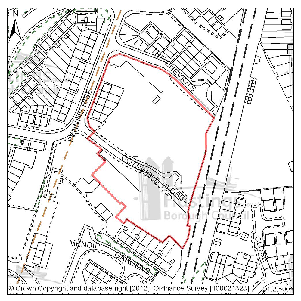
Figure 70: Location plan for B08
Site address: The Cheviots/Cotswold Close
Suggested use: Residential
Planning status: Outline planning permission subject to a legal agreement
Area: 1.23ha
Possible net capacity: 63
Assessment summary: The suitability of developing this site for housing has been established through an earlier resolution to approve a planning application subject to a legal agreement. Our preference would be to allocate this site for residential development with an indicative site capacity of 63 units.
Previously your comments were:
None
(4) Site reference: C05
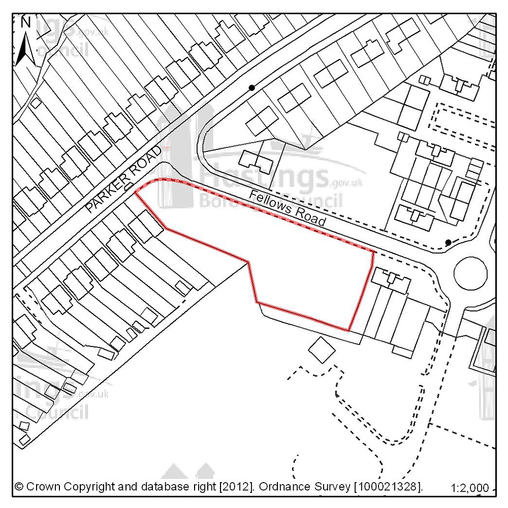
Figure 71: Location plan for C05
Site address: 2-20 (evens) Fellows Road
Suggested use: Residential
Planning status: Outline planning permission subject to a legal agreement
Area: 0.27ha
Possible net capacity: 17
Assessment summary: The suitability of developing this site for housing has been established through an earlier resolution by the Planning Committee to approve a planning application subject to a legal agreement. Our preference would be to allocate this site for residential development with an indicative site capacity of 17 units.
Previously your comments were:
None
(3) Site reference: C26 (previously C09)
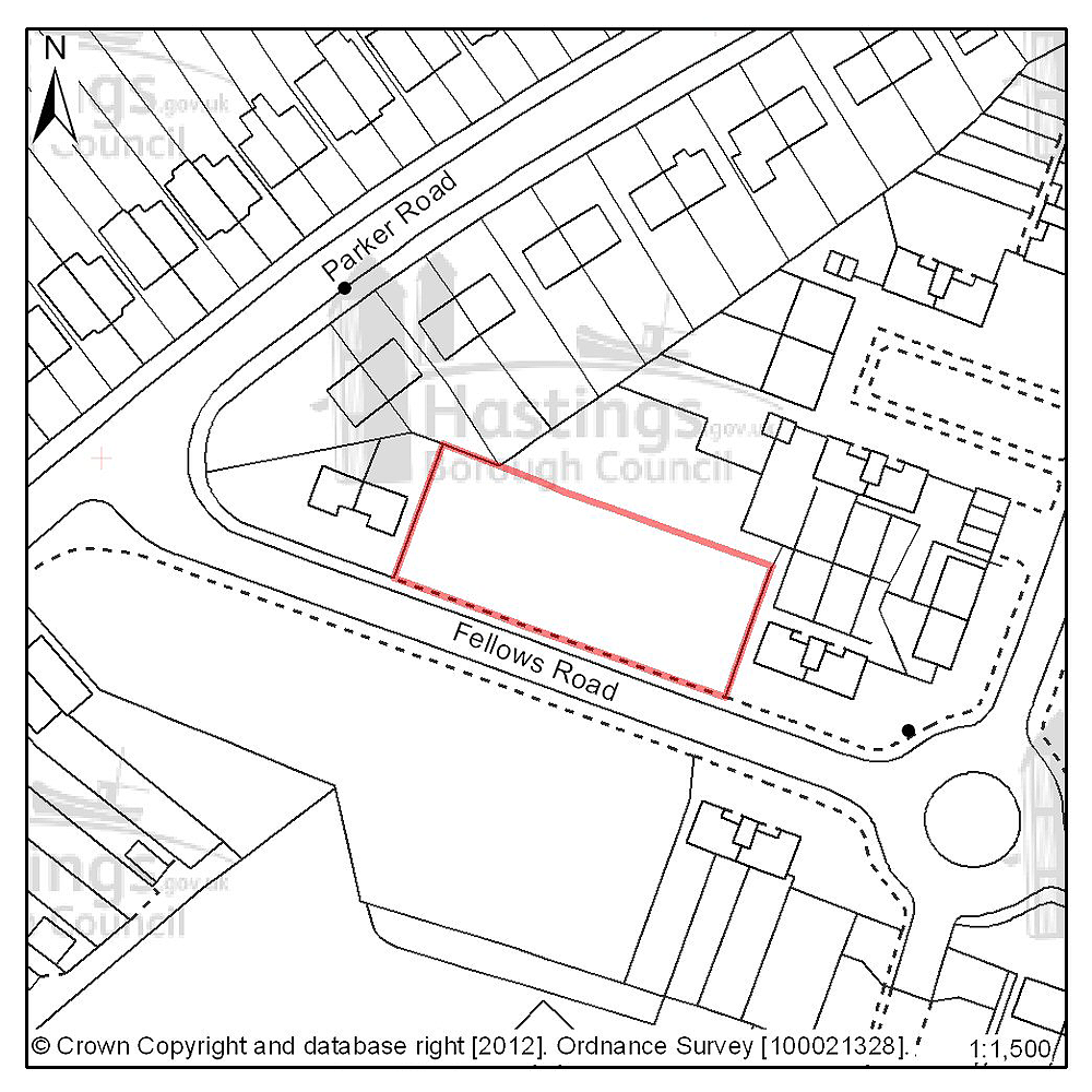
Figure 72: Location plan for C26
Site address: 5-15 (odds) Fellows Road
Suggested use: Residential
Planning status: Outline planning permission subject to a legal agreement
Area: 0.10ha
Possible net capacity: 12
Assessment summary: The suitability of developing this site for housing has been established through a current outline planning permission. Our preference would be to allocate this site for residential development with an indicative capacity of 12 units.
Previously your comments were:
None
(5) Site reference: B49 (formerly B34)
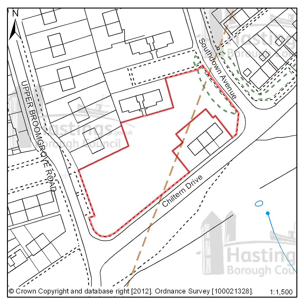
Figure 73: Location plan for B49
Site address: Upper Broomgrove Road
Suggested use: Residential
Planning status: None
Area: 0.29ha
Possible net capacity: 12
Assessment summary: The suitability of developing this site for housing has been established through a current outline planning permission. Our preference would be to allocate this site for residential development with an indicative capacity of 12 units.
Previously your comments were:
None
(4) Site reference: D28
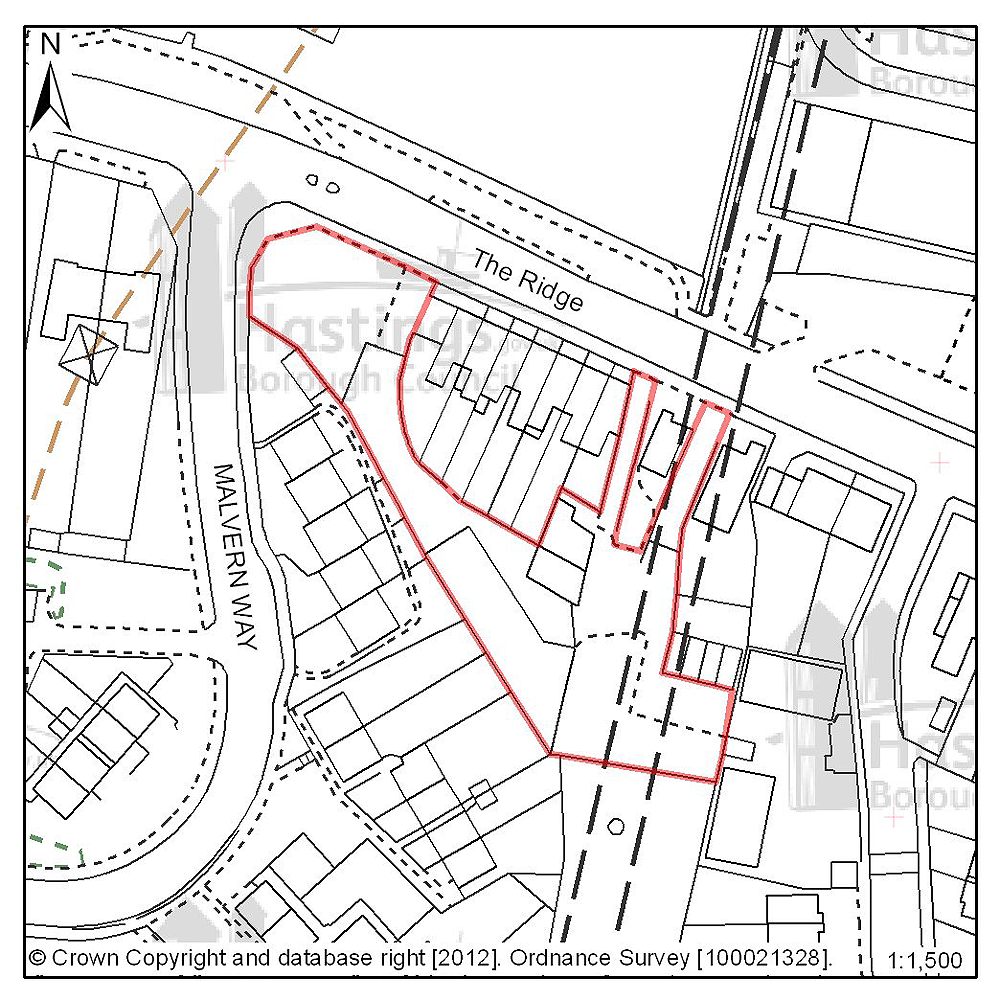
Figure 74: Location plan for D28
Site address: 107 The Ridge (Simes & Sons)
Suggested use: Residential
Planning status: Outline planning permission
Area: 0.22ha
Possible net capacity: 8
Assessment summary: The suitability of developing this site for housing has been established through an earlier resolution by the Planning Committee to approve a planning application subject to a legal agreement. Our preference would be to allocate this site for residential development with an indicative site capacity of 8 units.
Previously your comments were:
None
(6) Site reference: A02
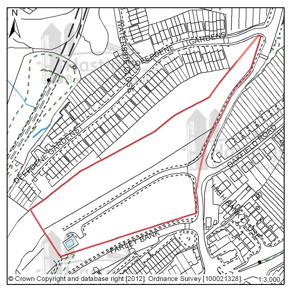
Figure 75: Location plan for A02
Site address: Former Mount Pleasant Hospital, Frederick Road
Suggested use: Residential
Planning status: Allocated in the Hastings Local Plan 2004
Area: 1.84ha
Possible net capacity: 8
Assessment summary: This site is identified for residential development in the existing Local Plan. The site forms part of wider area of neglected and redundant land known as Ore Valley, the regeneration of which has been a long term objective of the Council. The introduction of new housing to this area is see as being both beneficial the immediate locality and the town as a whole. Ore Valley was to be redeveloped as part of the millennium community programme, and the original outline planning permission included housing, together with commercial, retail and higher education facilities. The first phase of this scheme is now nearing completion. Nationally the millennium communities’ programme has now ended. Our preference is to continue to allocate this site for residential development as part of the wider Ore Valley redevelopment area. The site has an indicative capacity of 40 units.
Previously your comments were:
None
(5) Site reference: B09
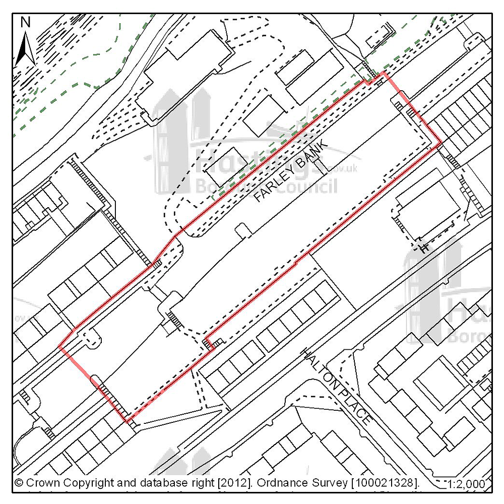
Figure 76: Location plan for B09
Site address: 87-221 (odds) Farley Bank
Suggested use: Residential
Planning status: Full planning permission subject to a legal agreement
Area: 0.73ha
Possible net capacity: 44
Assessment summary: This site has full planning permission for residential development. Our preference would be to allocate this site for residential development with an indicative capacity of 44 units.
Previously your comments were:
None
(6) Site reference: D57
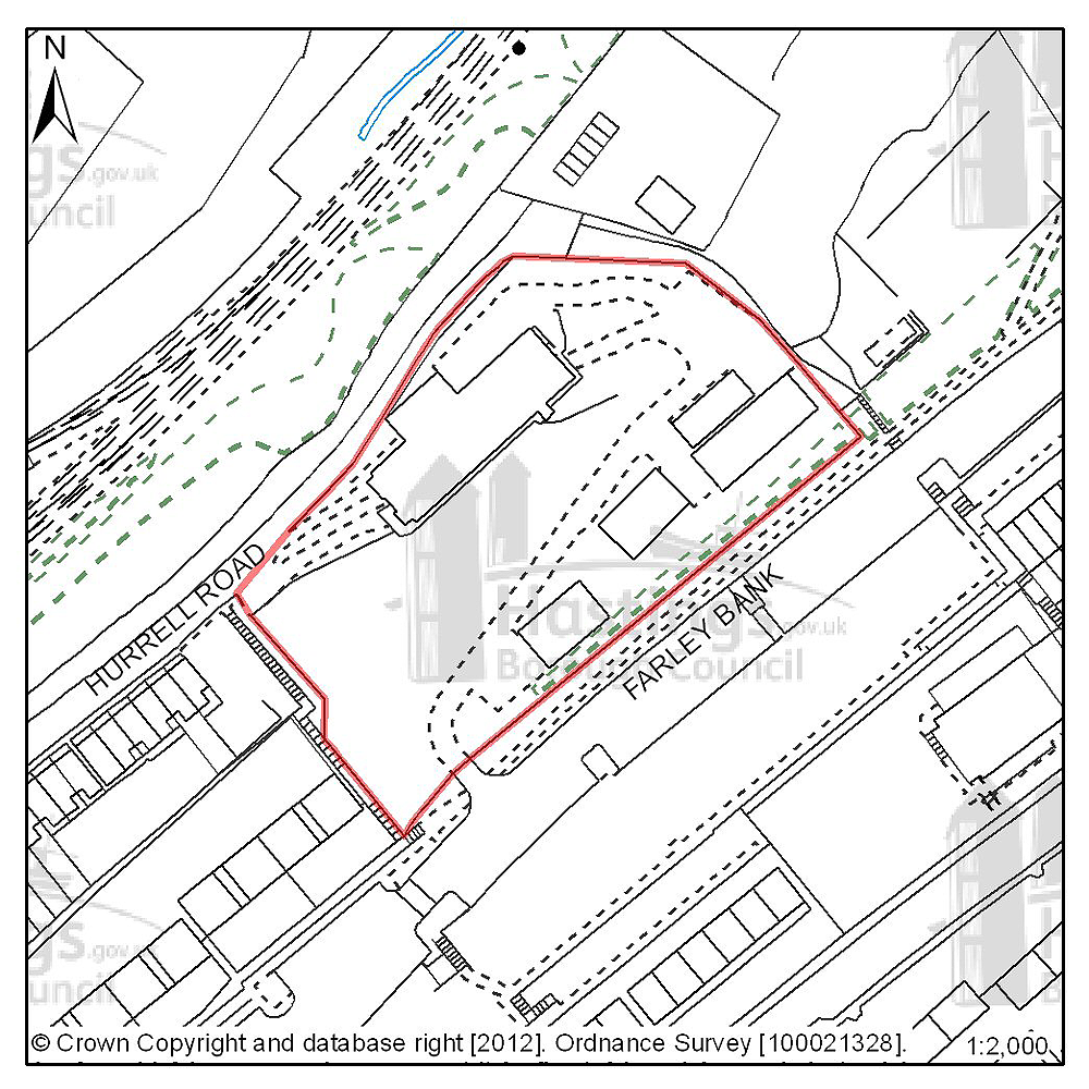
Figure 77: Location plan for D57
Site address: Ore Business Park, Farley Bank
Suggested use: Residential
Planning status: None
Area: 0.70ha
Possible net capacity: 37
Assessment summary: This site has full planning permission for residential development. Our preference would be to allocate this site for residential development with an indicative capacity of 37 units.
Previously your comments were:
None
(7) Site reference: E10
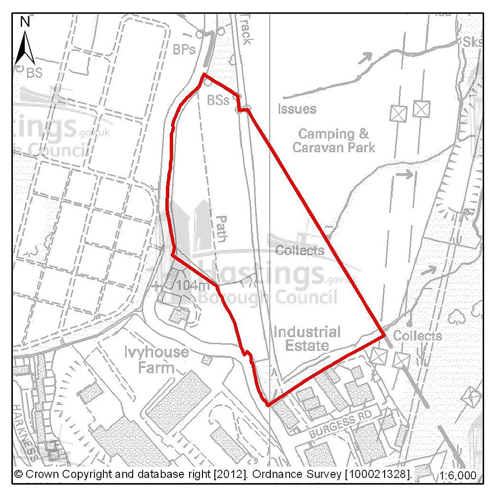
Figure 78: Location plan for E10
Site address: Ivyhouse Lane, northern extension
Suggested use: Employment
Planning status: Allocated in the Hastings Local Plan 2004
Area: 5.8ha
Possible net capacity: 10,000m2
Assessment summary: Located on the northern edge of the town, with views over the surrounding countryside. This site would form a natural extension to the Ivyhouse Employment Area. The site falls within the Area of Outstanding Natural Beauty but this was taken into account in allocating the site for development in the 2004 Plan.
A green lane runs across the site and is a constraint that would need to be taken into account in any development. The site is suitable for a range of small and medium units. The access to the site through the older Ivyhouse industrial area means that the site is unlikely to be suited to a prestige development but other parts of the Ivyhouse area have been developed independently in recent years and provides medium quality business space that makes a useful contribution to the town’s stock.
Previously your comments were:
None
(6) Site reference: E11
 <
<
Figure 79: Location plan for E11
/div>Site address: Land East of Burgess Road, Ivyhouse
Suggested use: Employment
Planning status: Allocated in the Hastings Local Plan 2004
Area: 0.4ha
Possible net capacity: 1,400m2
Assessment summary: This site would form an extension to the Ivyhouse Employment Area. The site falls within the Area of Outstanding Natural Beauty but this was taken into account in allocating the site for development in the 2004 Plan. The site is suitable for a range of small and medium units. The access to the site through the older Ivyhouse industrial area means that the site is unlikely to be suited to a prestige development but other parts of the Ivyhouse area have been developed independently in recent years and provides medium quality business space that makes a useful contribution to the town’s stock.
Previously your comments were:
None
Clive Vale & Ore Village (Planning Focus Area 12)
Table 23: Possible net number of dwellings on sites in Focus Area 12
| Site reference | Address | Possible net number of dwellings | Area (ha) | Planning status |
|---|---|---|---|---|
| D26 | Hare & Hounds, 391 Old London Road | 6 | 0.04 | Lapsed planning permission |
| D35 | 309-311 Harold Road | 6 | 0.09 | Full planning permission subject to legal agreement |
| A01 | Upper Ore Valley | 151 | 3.17 area with permission for 0.96, remainder 2.20 | Allocated in the Hastings Local Plan 2004 (full planning permission on part of the site) |
| A24 | Land west of Frederick Road | 29 | 0.60 | Full planning permission |
| A30 | Rear of Old London Road | See A01 | 0.23 | Allocated in the Hastings Local Plan 2004 |
Table 24: Potential gross employment floorspace on sites in Focus Area 12
| Site reference | Address | Potential gross floorspace (m2) | Area (ha) | Planning status |
|---|---|---|---|---|
| None | ||||
Planning Focus Area 12

Insert focus area map for Clive Vale and Ore Village Figure PFA12
(1) Site reference: D26
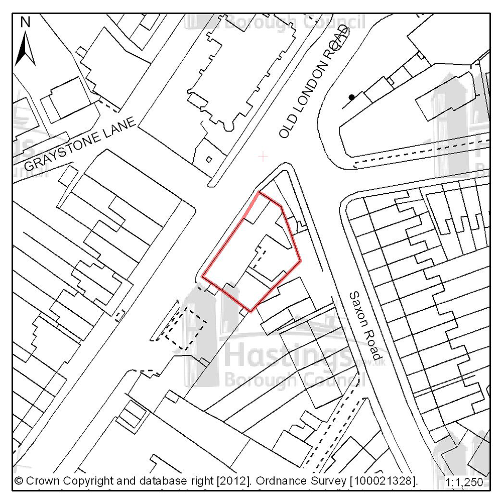
Figure 80: Location plan for D26
Site address: Hare & Hounds, 391 Old London Road
Suggested use: Residential
Planning status: Lapsed planning permission
Area: 0.04ha
Possible net capacity: 6
Assessment summary: Although planning permission for residential development has recently lapsed on this site, the site's suitability for residential development has been established. Our preference would be to allocate this site for residential development with an indicative capacity of 6 units.
Previously your comments were:
None
(2) Site reference: D35
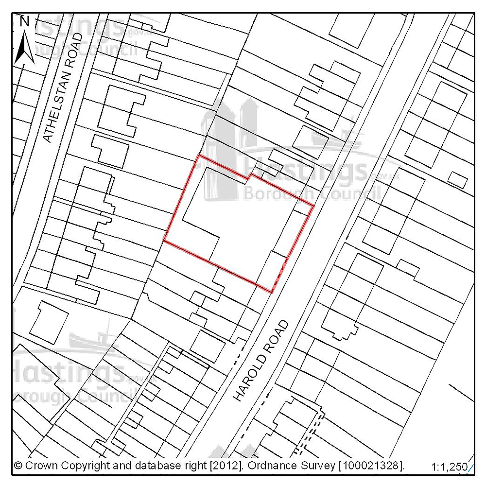
Figure 81: Location plan for D35
Site address: 309-311 Harold Road
Suggested use: Residential
Planning status: Full planning permission subject to legal agreement
Area: 0.09ha
Possible net capacity: 6
Assessment summary: The suitability of developing this site for housing has been established through an earlier resolution by the Planning Committee to approve a planning application subject to a legal agreement. Our preference would be to allocate this site for residential development with an indicative site capacity of 6 units
Previously your comments were:
None
(176) Site reference: A01

Figure 82: Location plan for A01
Site address: Upper Ore Valley
Suggested use: residential
Planning status: Allocated in the Hastings Local Plan 2004, with full planning permission on part of the site
Area: 3.17ha
Possible net capacity: 151
Assessment summary: This site is allocated for residential development in the existing Local Plan and currently has planning permission for residential development on part of the site. Vehicular access to the southern portion of the site, which is expected to be from the northern portion of the site, will need to be resolved before development can go ahead. There has been developer interest in the whole site, including the southern portion. Our preference is to continue to allocate this site for housing, which could include the land indicated in A30, with an indicative capacity of 151 units.
Previously your comments were:
- Designate as green/open space
- Should be kept as green space
- Woodland should be protected & added to the greenspace strategy
- Environmental value shouldn’t be lost
- Too many owners
- Surface water capture
- Steeply sloping sides – too impractical to develop
- Conflicts with policy restrictions
- Not suitable for development
- The area behind Old London Road is not practically developable due to ESCC Highways restrictions
- Poor road links & infrastructure issues in this area
(4) Site reference: A24

Figure 83: Location plan for A24
Site address: Land west of Frederick Road
Suggested use: Residential
Planning status: Full planning permission
Area: 0.60
Possible net capacity: 29
Assessment summary: This site is allocated for residential development in the existing Local Plan and currently has planning permission for residential development. Our preference is to continue to allocate this site for housing with an indicative net capacity of 29 units.
Previously your comments were:
None
(161) Site reference: A30
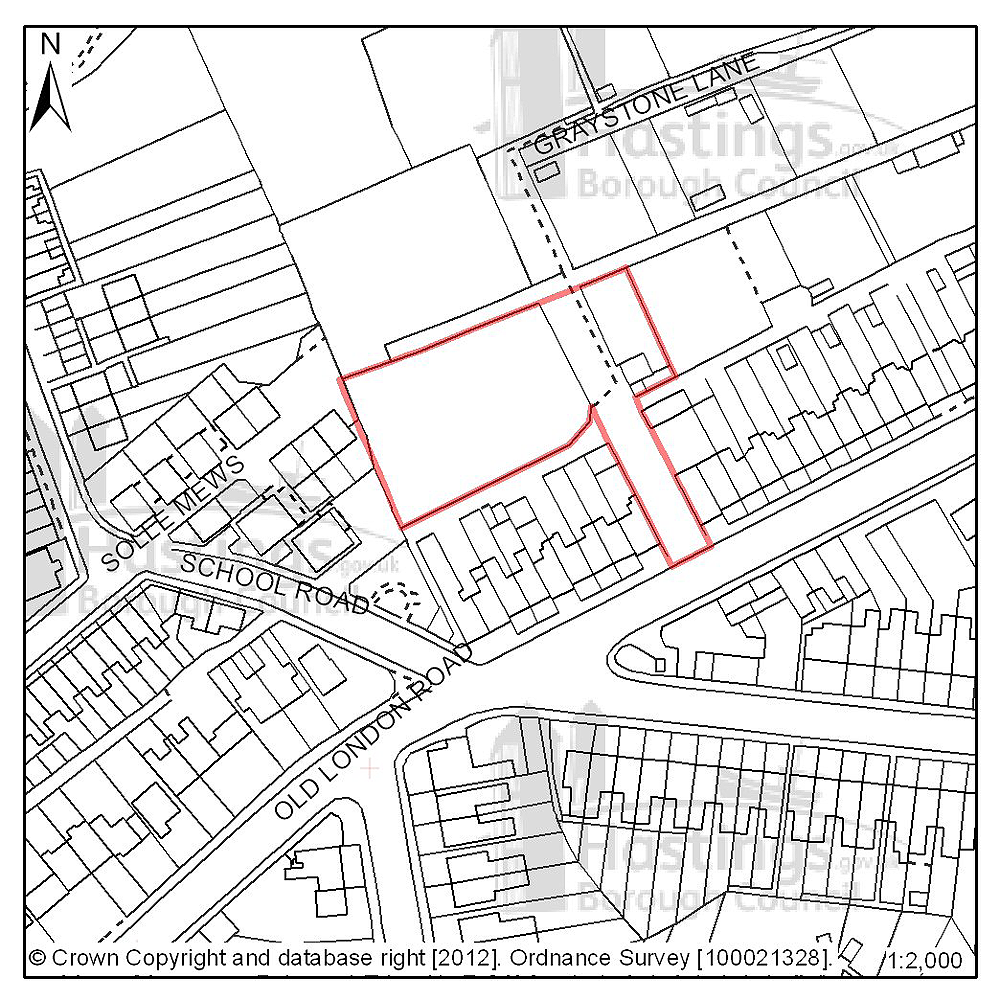
Figure 84: Location plan for A30
Site address: Rear of Old London Road
Suggested use: Residential
Planning status: Allocated in the Hastings Local Plan 2004
Area: 0.23
Possible net capacity: See A01
Assessment summary: See summary at A01
Previously your comments were:
- Retain as green space
- Traffic access difficulties
Hastings Country Park (Planning Focus Area 13)
Table 25: Possible net number of dwellings on sites in Focus Area 13
| Site reference | Address | Possible net number of dwellings | Area (ha) | Planning status |
|---|---|---|---|---|
| None | ||||
Table 26: Potential gross employment floorspace on sites in Focus Area 13
| Site reference | Address | Potential gross floorspace (m2) | Area (ha) | Planning status |
|---|---|---|---|---|
| None | ||||
Planning Focus Area 13
Sites under construction
A number of housing sites which aren’t shown in this consultation document are currently under construction. It is expected that these sites will be completed in the short term, although some schemes are far closer to completion than others. These schemes will count towards meeting the housing target figure of 3,400 new homes by 2028. Because the Plan period runs from 2011 to 2028, all schemes that have been completed since April 2011 count towards the target figure of 3,400.
Table 27: Sites under construction
| Site reference | Address | Net number of dwellings | Area (ha) | Planning status | |
|---|---|---|---|---|---|
| Focus Area 2: Greater Hollington | |||||
| A10 | Mayfield Heights, Mayfield Lane | 67 | 1.61 | Under construction, part completed | |
| D27 | Land rear of 20 Wartling Close | 9 | 0.50 | Under construction | |
| Focus Area 3: Filsham & Bulverhythe | |||||
| A13 | Land adjoining 73 Filsham Rd | 35 | 0.67 | Under construction | |
| A05 | Former Malmesbury House, West Hill Road | 117 | 0.70 | Certificate of lawfulness confirms a start has been made on this site. However not currently active. | |
| B07 | Land at Fern Road | 14 | 0.44 | Certificate of lawfulness confirms a start has been made on this site. More recently a new planning permission has been allowed on appeal but the site is also the subject of a town or village green application. A public inquiry was held which concluded on 26 January 2012 and the outcome is awaited. Currently there is no certainty that this site will be developed but it remains a possibility at this time | |
| Focus Area 5: Silverhill & Alexandra Park | |||||
| D29 | Land off Robert Tressell close | 9 | 0.41 | Under construction | |
| D37 | land rear of 1-9 Amherst Rd | 6 | 0.30 | Under construction | |
| Focus Area 6: Maze Hill & Burton’s St.Leonards | |||||
| D46 | Land at Undercliffe | 16 | 0.09 | Start on site not currently active | |
| Focus Area 7: Central St Leonards & Bohemia | |||||
| D05 | rear of 22-24 King's Road | 8 | 0.04 | Under construction | |
| Focus Area 9: Old Town | |||||
| D10 | The Tan House & Ice House, 24 Rock-a-nore | 14 | 0.06 | Under construction | |
| Focus Area 10: West Hill | |||||
| A03 | 101 Castle Hill Road | 7 | 0.07 | Start on site not currently active | |
| Focus Area 11: Hillcrest & Ore Valley | |||||
| A06 | Land north of Priory Road | 38 | 0.68 | Under construction, part completed | |
| A17 | land at the corner of Hughenden Rd & Parker Rd, Ore Valley Phase 1A | 51 | 2.55 | Under construction | |
| D38 | 141 The Ridge | 13 | 0.26 | Under construction | |
| Focus Area 12: Clive Vale & Ore Valley | |||||
| A25 | Land at Hawthorn Rd | 16 | 0.52 | Under construction | |
| D47 | Land at 2 Tilekiln Lane | 13 | 0.33 | Start on site not currently active | |