
Development Management Plan Revised Proposed Submission Version March 2014
(9) Section Three - Site Allocations
Introduction to Site Allocations
6.1 Policy DS1 of the Planning Strategy sets a target of at least 3400 new homes to meet the housing needs of Hastings between 2011 and 2028. This will not all be new housing allocations, as the total includes homes completed and under construction and existing planning permissions. Strategic Policies FA1, FA2 and FA5 show a broad distribution of the proposed housing land supply. Individual sites are to be identified in this Plan.
6.2 Similarly, Policy DS2 identifies a need for the development of up to 70,000m2 of employment floor space in the town between 2008 and 2028.
6.3 To provide a local perspective and sense of place, the Planning Strategy divides the town into 13 Planning Focus Areas. These are areas based upon statistical Super Output Areas and they have an identifiable community or geography or where landscape or function means that they make a logical area for spatial planning. A plan showing the boundaries of the 13 areas is shown over the page.
6.4 This section of the Development Management Plan looks at the Planning Focus Areas (referred to as Focus Areas) in some detail. Set out within the pages for each area is a description of the main characteristics of it and a vision for its future.
6.5 The housing and employment allocations are set out in a schedule in each Focus Area (FA). This is followed by a small site map and accompanying allocation details. Each site is accompanied by a policy to guide development on that site. Some larger sites also have a design brief set out in Appendix A.
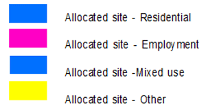
Planning Focus Area Maps legend
The Planning Focus Areas
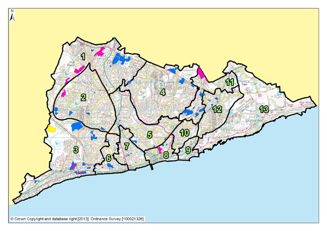
Figure 6: The Planning Focus Areas
Focus Area 1: Little Ridge & Ashdown
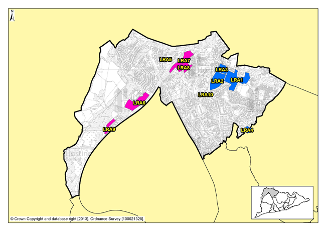
Figure 7: Focus Area 1- Little Ridge & Ashdown
Introduction to the Little Ridge & Ashdown Focus Area
6.6 This is where Hastings’ urban fringe meets the surrounding countryside, with recent housing developments edging into woodland, fields and farmland. It is where visitors to Hastings arriving by road from London get their first glimpse of the sea, with long and often breathtaking views, especially from high points on The Ridge.
6.7 Little Ridge & Ashdown covers the parts of the Borough to the north of Silverhill and west from the Conquest Hospital, including semi-rural areas to the west of Queensway. It is a mixed area, with good quality and well maintained, predominately post-war, housing and two of the town’s largest employers: the Conquest Hospital and the Child Support Agency. The area includes a major supermarket whose draw extends well beyond the immediate locality and some other retail outlets. The presence of various employers in the Focus Area, including tourist accommodation at the Beauport Park holiday village, the Premier Inn and Bannatyne’s hotel and spa, and leisure developments, create opportunities for people to live and work in relatively close proximity, allows local workers the chance to walk or cycle to work. A mix of housing will help to maintain a vibrant community.
6.8 There are also good public transport connections to the Conquest Hospital, supermarkets, to Hastings Town Centre and beyond. The connectivity allows for a choice of travel options for work and pleasure. This connectivity does, however, come at the cost of some particularly busy roads, and the junctions of the A259, the A21 and The Ridge lie within this area.
6.9 However, Little Ridge & Ashdown is not just a mix of housing and industrial suburbia. There are recreation grounds, allotments, extensive areas of open farmland at the western fringe of the Borough and, most significantly, the Marline Valley, a Site of Special Scientific Interest (SSSI) which includes woodland, meadows and a steep-sided valley covering forty hectares of open space to the west of Queensway.
6.10 Housing in Little Ridge & Ashdown is predominately owner-occupied (according to 2001 Census data over 80% of the residences are owned by their occupants), and most are suburban family homes. The demographic data for the area (again from the 2001 Census), shows an even mix of age groups, reinforcing the fact that this is an area where many families live.
Our Vision for Little Ridge & Ashdown
6.11 A major change to this area during the Plan period will be the completion of the Bexhill - Hastings Link Road. This will allow drivers the choice to travel either on Bexhill Road and Hastings seafront, or onto The Ridge to continue their journeys east and west. It will also allow for better and simpler access to the A21 for travel north towards London. The Baldslow Link will also be an important part of improved road connections. Whilst the Bexhill - Hastings Link Road will improve transport options for local people, businesses and tourists; careful management of traffic flow, especially at existing major junctions and near potential development sites, will need to be considered. Development proposals all along The Ridge will need to show consideration of the traffic impact onto and off of this locally important traffic route.
6.12 Building the Bexhill - Hastings Link Road will aid in the development of commercial and employment areas along Queensway, particularly at the northern end. Better traffic flow in these areas will help to increase the opportunities for improved access to the sites. This is an opportunity for new commercial developments offering extra employment opportunities, but it should not be to the detriment of ecology, particularly the woodland, of the area.
6.13 Public open spaces are important here in blending the urban area into the surrounding countryside. The Marline Valley SSSI will continue to be protected. Allotments and open spaces are important to local communities and these will be managed and where possible enhanced. Tourist accommodation provision in Little Ridge & Ashdown is something that the Council would also like to see protected and we will consider ways to increase it.
6.14 Policy FA1 of the Planning Strategy states that the provision for 220 – 280 extra homes is required in Little Ridge & Ashdown over the next fifteen years, and most of these will be delivered through new development on allocated sites. There is a particular development opportunity at Holmhurst St Mary, a former convent school and surrounding grounds, land next to it at 777 the Ridge and the neighbouring playing field. Together, these sites have the potential to provide a significant number of new homes, with a mix of properties for all, including families, workers for the hospital, and employees of the local light industrial and commercial sites. A benefit of these sites coming forward together in a well phased manner could be to allow for an integrated development, including an improvement to the recreation facilities and the opportunity for the community to take some ownership, and for locally important wildlife habitats and green spaces to be protected and also properly connected.
6.15 South of The Ridge West and along Queensway, there are opportunities to increase the volume of industrial and commercial premises and to strengthen the links between the Hastings labour force and the town’s exports and the wider market of the UK and beyond. The Bexhill - Hastings Link Road will aid in the continued growth of business and employment in this part of the Borough. Situating these kinds of premises near to one another increases the opportunities for similar businesses to set up and share expertise and knowledge. The new commercial area on Queensway – the Queensway Employment Corridor – with the Enviro 21 Park, an environmentally sustainable industrial park, will act as a catalyst to other businesses and premises. These, and the presence of the Sussex Exchange Business Centre, means that future employment opportunities in this area are strong.
6.16 The eclectic nature of architectural styles in Little Ridge & Ashdown allows for development proposals of all sizes to have a degree of flexibility. There is a need to provide a mixture of tenures in the area where possible, in order to maintain a sustainable community which has access to a range of local shops and services. We will continue to encourage the inclusion of affordable and social housing in schemes, especially in this Focus Area, where there is less provision than elsewhere. Affordable housing, especially for locally employed people, a small amount of flatted development and also some larger family homes will maintain the suburban feel of this area of the Borough, and help to maintain the quality of the built environment.
Residential, mixed use and other allocations for Little Ridge & Ashdown
| Site reference | Address |
Reason for allocation (including potential number of homes) |
Area (ha) | Does the site have a brief in Appendix A? |
|---|---|---|---|---|
| LRA1 | Holmhurst St Mary | Residential (165) | 6.98 |

|
| LRA2 | Harrow Lane Playing Fields | Residential (140) | 4.75 |
|
| LRA3 | Land adjacent to 777 The Ridge | Residential (10) | 1.86 |
|
| LRA4 | Old Roar House, Old Roar Road | Residential (14) | 0.84 |

|
| LRA5 | Former Workplace Health & Fitness Centre, The Ridge West | Residential (11) | 0.47 |
|
| LRA10 | Land north of Downey Close | Residential (7) | 0.24 |
|
Table 1: Residential, mixed use and other allocations for Little Ridge & Ashdown
Employment allocations for Little Ridge & Ashdown
| Site reference | Address | Potential gross floorspace (m2) | Area (ha) | Does the site have a brief in Appendix A? |
|---|---|---|---|---|
| LRA6 | Queensway North, Queensway | 9,700 | 4.70 |
|
| LRA7 | Land at junction of The Ridge West and Queensway |
6,000 Up to 12,000 if combined with site LRA8 |
3.37 |
|
| LRA8 | Land in Whitworth Road, The Ridge West |
6,000 Up to 12,000 if combined with site LRA7 |
2.51 |
|
| LRA9 | Marline Fields, Enviro21 Business Park, Land West of Queensway | 5,600 | 1.48 |
|
Table 2: Employment allocations for Little Ridge & Ashdown
Site reference: LRA1 - Holmhurst St Mary
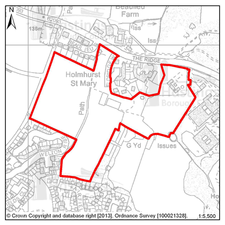
Figure 8: LRA1 - Holmhurst St Mary
Site address: Holmhurst St Mary
Allocated use: Residential
Area: 6.98ha
Possible net capacity: 165
6.17 Site LRA1 – Holmhurst St Mary is a large Greenfield site in the north of the Borough adjacent to The Ridge. The form of any proposed development would need to take into account such matters as the established landscaping, the ecology, the adjacent Local Wildlife Site and the position of a Grade II* listed statue (the statue is currently on the English Heritage “at risk” register and will need to be repaired and consolidated as part of any development scheme). There is also a Nun’s cemetery on the site and just beyond the northern boundary is the Grade II listed Holmhurst St Mary School.
6.18 Given the size and location of the site the Council will expect any scheme to support a varied housing mix and may be required to include specific housing for wheelchair users, and affordable housing will also be required as part of the mix. The site is also in an identified area that is lacking in quality children’s play provision and this may be required within a proposed scheme or a contribution sought to improve a local facility. There is a small area of surface water flood risk on site so this will need to be investigated and mitigated as appropriate. Sewerage and drainage will also need to be properly integrated into any scheme because this is a Greenfield site there is insufficient at present. Development proposals will need to show consideration of the transport impact along The Ridge. Further advice on transport matters is available from East Sussex County Council.
6.19 The two neighbouring sites LRA2 and LRA3 give the opportunity for effective planning of greater walking and cycling connectivity, which will contribute to the green infrastructure network. Improved connections between the open and green spaces will support their ecological and recreational value.
6.20 The combination of these three sites and the proximity of the hospital also provide the potential for district heating, so the Council expects the proponents of any scheme on each of the LRA1, LRA2 and LRA3 sites to investigate the feasibility of district heating networks and/or combined heat and power systems.
(2)
 Policy
LRA1 - Holmhurst St Mary
Policy
LRA1 - Holmhurst St Mary
Holmhurst St Mary is allocated for residential development (possible net capacity 165 dwellings).
The Council expects development proposals for this site to:
-
Include affordable housing on site at 40% of the overall housing provision;
-
Include at least 2% of the total number of new homes as fully adapted dwellings for wheelchair users ;
-
Sustain and enhance the significance and setting of the Grade II listed Holmhurst St Mary School and the Grade II* listed statue of Queen Anne;
-
Include an Ecological Constraints and Opportunities Plan, including specific reference to the presence of the adjacent Local Wildlife Site, and incorporate conservation and mitigation measures as recommended by the plan as appropriate. Public access to the Local Wildlife Site should also be indicated within schemes;
-
Provide green space within the site and boundary landscaping to act as a buffer to surrounding development;
-
Provide an arboriculture plan that demonstrates how existing trees on site will be integrated into the development, or how compensation will be made for their loss;
-
Include a Flood Risk Assessment and incorporate measures to address surface water flood risk such as Sustainable Drainage Systems;
-
Investigate the feasibility for district heating and/or Combined Heat and Power systems on site;
-
Contribute to the improvement of existing play facilities in the surrounding area;
-
Include walking and cycling links to neighbouring development sites to improve local connectivity and to preserve the Public Right of Way across the site;
-
(1) Be supported by a Transport Assesment and Travel Plan. The Transport Assessment will need to take account of the site’s proximity to The Ridge. Proposals should indicate how the conclusions and recommendations of the assessment have been incorporated. Potentially development may be required to contribute to improvements on The Ridge;
-
Provide a connection to the sewerage and water supply systems at the nearest point of adequate capacity, as advised by Southern Water and ensure future access to the existing sewerage infrastructure for maintenance and upsizing purposes.
Additional guidance (that includes opportunities to connect to adjoining sites) is also given in a site design brief in Appendix A.
All policies of the Local Plan will be applied, as appropriate, to any scheme presented to the Council.
Site reference: LRA2 - Harrow Lane Playing Fields
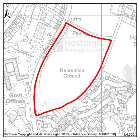
Figure 9: LRA2 - Harrow Lane Playing Fields
Site address: Harrow Lane Playing Fields
Allocated use: Residential
Area: 4.75ha
Possible net capacity: 140
6.21 Site LRA2 – Harrow Lane playing fields was protected in the Local Plan 2004 as playing fields. Its use as a site for football fields/active recreation has ceased, and it is now surplus to open space provision requirement. Therefore the Council allocates this site for residential use.
6.22 LRA2 is an elevated site situated above the road and the office and residential area to the east. The boundary of the site is made up of well treed hedgerows, except at the south west corner where there are long views to Beachy Head.
6.23 Given the size and location of the site the Council will expect any scheme to support a varied housing mix and may be required to include specific housing for wheelchair users, and affordable housing will also be required as part of the mix. The site is also in an identified area that is lacking in quality children’s play provision and this may be required within a proposed scheme or a contribution sought to improve a local facility. Sewerage and drainage will also need to be properly integrated into any scheme because this is a Greenfield site there is insufficient at present. There is a risk of surface water flooding so this will need to be investigated as part of a Flood Risk Assessment, because of the size of the site, appropriate mitigation measures should be incorporated.
6.24 The development should incorporate measures to help maintain its wooded appearance particularly from Harrow Lane with strengthened boundary planting. There are also public right of way routes running around the perimeter which should be accommodated within any development proposals. Development proposals will need to show consideration of the transport impact along The Ridge. Further advice on transport matters is available from East Sussex County Council.
6.25 The two neighbouring sites LRA1 and LRA3 give the opportunity for effective planning of greater walking and cycling connectivity, which will contribute to the green infrastructure Network. Improved connections between the open and green spaces will support their ecological and recreational value. Of particular importance will be the connectivity to the open space beyond LRA1, as the loss of the existing amenity of the playing fields will be lessened by access to other open space. The combination of these three sites and the proximity of the hospital also provide the potential for district heating.
(6)
Policy
LRA2 - Harrow Lane Playing Fields
Harrow Lane Playing Fields is allocated for residential development (possible net capacity 140 dwellings).
The Council expects development proposals for this site to:
-
(1) Include affordable housing on site at 40% of the overall housing provision;
-
Include at least 2% of the total number of new homes as fully adapted dwellings for wheelchair users;
-
Include an Ecological Constraints and Opportunities Plan and incorporate conservation and mitigation measures as recommended by the Plan as appropriate;
-
(2) Provide new green space within the site and boundary landscaping to act as a buffer to surrounding development and Harrow Lane;
-
Provide an arboriculture plan that demonstrates how existing trees on site will be integrated into the development, or how compensation will be made for their loss;
-
Include a Flood Risk Assessment and incorporate measures to address surface water flood risk such as Sustainable Drainage Systems;
-
Investigate the feasibility for district heating and/or Combined Heat and Power systems on site;
-
(1) Contribute to the improvement of existing play facilities in the surrounding area;
-
Include walking and cycling links to neighbouring development sites to improve local connectivity and to preserve the Public Right of Way around the site;
-
(1) Be supported by a Transport Assessment and Travel Plan. The Transport Assessment will need to take account of the site’s proximity to The Ridge. Proposals should indicate how the conclusions and recommendations of the assessment have been incorporated. This is likely to include improved access from Harrow Lane. Potentially development may be required to contribute to improvements on The Ridge;
-
Provide a connection to the sewerage and water supply systems at the nearest point of adequate capacity, as advised by Southern Water and ensure future access to the existing sewerage infrastructure for maintenance and upsizing purposes.
Additional guidance (that includes opportunities to connect to adjoining sites) is also given in a design brief for this site in Appendix A.
All policies of the Local Plan will be applied, as appropriate, to any scheme presented to the Council.
Site reference: LRA3 - Land adjacent to 777 The Ridge
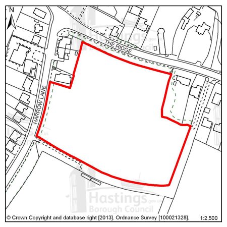
Figure 10: LRA3 - Land adjacent to 777 The Ridge
Site address: Land adjacent to 777 The Ridge
Allocated use: Residential
Area: 1.86ha
Possible net capacity: 10
6.26 Site LRA3 – Land adjacent to 777 The Ridge is a Greenfield site occupying an elevated position at the junction of Harrow Lane with The Ridge. The site does not fall within any landscape designation but the Area of Outstanding Natural Beauty (AONB) lies on the opposite side of The Ridge. There are long views to the north into and out of the AONB, and this is likely to constrain the scale and form of development on this site. Planting on the northern boundary could enable part of the site to be developed but low profile development would be essential on this elevated site. The site is also within an Archaeological Notification Area. Development proposals will need to show consideration of the transport impact along The Ridge. Further advice on transport matters is available from East Sussex County Council.
6.27 The two neighbouring sites LRA1 and LRA2 give the opportunity for effective planning of greater walking and cycling connectivity, which will contribute to the green infrastructure Network. Improved connections between the open and green spaces will support their ecological and recreational value. The combination of these three sites and the proximity of the hospital also provide the potential for district heating. The size of the whole site is over 1 hectare so, as advised by the Environment Agency, a Flood Risk Assessment is required.
(3)
Policy
LRA3 - Land adjacent to 777 The Ridge
Land adjacent to 777 The Ridge is allocated for residential development (possible net capacity 10 dwellings).
The Council expects development proposals for this site to:
-
Include affordable housing on site at 20% of the overall housing provision;
-
Include a Historic Environment Record (HER) informed desk-based assessment of potential interest within an archaeological notification area and agree to a ‘watching brief’ during any development works (as advised by East Sussex County Council);
-
Include an Ecological Constraints and Opportunities Plan and incorporate conservation and mitigation measures as recommended by the Plan as appropriate;
-
Provide new green space within the site and boundary landscaping;
-
Provide an arboriculture plan that demonstrates how existing trees on site will be integrated into the development, or how compensation will be made for their loss;
-
(1) Include measures to conserve and enhance the Area of Outstanding Natural Beauty;
-
Include a Flood Risk Assessment and flood resilient design as appropriate to the outcome of that report;
-
Provide a contribution to the improvement of existing play facilities in the surrounding area;
-
Include walking and cycling links to neighbouring development sites to improve local connectivity and to preserve the Public Right of Way around the site;
-
(1) Be supported by a Transport Report. The report will need to take account of the site’s proximity to The Ridge. Proposals should indicate how the conclusions and recommendations of the Report have been incorporated. This is likely to include improved access from Harrow Lane. Potentially development may be required to contribute to improvements on The Ridge.
Additional guidance is also given in a design brief for this site in Appendix A.
All policies of the Local Plan will be applied, as appropriate, to any scheme presented to the Council.
Site reference: LRA4 - Old Roar House, Old Roar Road
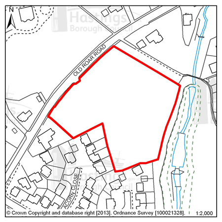
Figure 11: LRA4 - Old Roar House, Old Roar Road
Site address: Old Roar House, Old Roar Road
Allocated use: Residential
Area: 0.84ha
Possible net capacity: 14
(1) 6.28 Site LRA4 – Old Roar House, Old Roar Road is a cleared site that was previously a residential children’s home. To the south is an area of residential properties and to the east is the northern end of Alexandra Park. There are mature trees on most of the boundaries of the site. The capacity potential of this site indicates that a Transport Report will be required, further advice is available from East Sussex County Council.
Policy
LRA4 - Old Roar House, Old Roar Road
Old Roar House, Old Roar Road is allocated for residential development (possible net capacity 14 dwellings).
The Council expects development proposals for this site to:
-
Include affordable housing on site at 20% of the overall housing provision;
-
Include an Ecological Constraints and Opportunities Plan, including specific reference to the presence of the adjacent Local Wildlife Site, and incorporate conservation and mitigation measures as recommended by the Plan as appropriate;
-
Provide new green space within the site and boundary landscaping to act as a buffer to surrounding development.
-
Be supported by a Transport Report. Proposals should indicate how the conclusions and recommendations of the Report have been incorporated.
All policies of the Local Plan will be applied, as appropriate, to any scheme presented to the Council.
Site reference: LRA5 - Former Workplace Health & Fitness Centre, The Ridge West
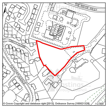
Figure 12: LRA5 - Former Workplace Health & Fitness Centre, The Ridge West
Site address: Former Workplace Health & Fitness Centre, The Ridge West
Allocated use: Residential
Area: 0.47ha
Possible net capacity: 11
6.29 Site LRA5 – Former Workplace Health & Fitness Centre, The Ridge West is a cleared and vacant site. It is between existing residential development to the west and the Southern Water supply treatment works to the north. To the south is Croft Lodge, a Grade II listed building, set behind a significant screen of vegetation and to the east is further established woodland. The site is also within an Archaeological notification area. Development proposals will need to show consideration of the transport impact along The Ridge. Further advise on transport matters is available from East Sussex County Council.
Policy
LRA5 - Former Workplace Health & Fitness Centre, The Ridge
West
Former Workplace Health & Fitness Centre, The Ridge West is allocated for residential development (possible net capacity 11 dwellings).
The Council expects development proposals for this site to:
-
Include affordable housing on site at 20% of the overall housing provision;
-
Sustain and enhance the significance and setting of the Grade II listed Croft Lodge;
-
Include a Historic Environment Record (HER) informed desk-based assessment of potential interest within an archaeological notification area and agree to a ‘watching brief’ during any development works (as advised by East Sussex County Council);
-
Include an Ecological Constraints and Opportunities Plan and incorporate conservation and mitigation measures as recommended by the Plan as appropriate.
-
Be supported by a Transport Report. The Report will need to take account of the site’s proximity to The Ridge. Proposals should indicate how the conclusions and recommendations of the Report have been incorporated. Potentially development may be required to contribute to improvements on The Ridge.
All policies of the Local Plan will be applied, as appropriate, to any scheme presented to the Council.
Site reference: LRA10 - Land north of Downey Close
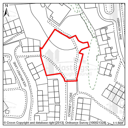
Figure 13: LRA10 - Land north of Downey Close
Site address: Land North of Downey Close
Allocated use: Residential
Area: 0.24
Possible net capacity: 7
6.30 Site LRA10 - Land north of Downey Close is a vacant site in a residential area. Building on this site would be a continuation of the existing development pattern. There are footpaths across the site and mature trees adjacent to it; these should be preserved as much as is practicable. The capacity potential of this site indicates that a Transport Report will be required, further advice is available from East Sussex County Council.
(1)
Policy
LRA10 - Land north of Downey Close
Land north of Downey Close is allocated for residential development (possible net capacity 7 dwellings).
The Council expects development proposals for this site to:
-
Include affordable housing on site at 20% of the overall housing provision;
-
Be supported by a Transport Report. Proposals should indicate how the conclusions and recommendations of the Report have been incorporated.
All policies of the Local Plan will be applied, as appropriate, to any scheme presented to the Council.
Site reference: LRA6 - Queensway North, Queensway
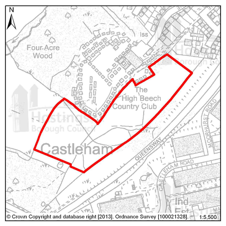
Figure 14: LRA6 - Queensway North, Queensway
Site address: Queensway North, Queensway Allocated use: Employment; B use classes Area: 4.70ha
Possible floorspace (gross): 9,700m2
6.31 Site LRA6 – Queensway North, Queensway is allocated for employment use. Its “partner” site, Queensway South, has been partially developed as part of the Enviro21 Business Park scheme and this could form a next phase. It is seen as suitable for high quality business development, possibly for a single large user or more likely for several medium sizes business units or a range of small ones. It has the potential for a total of c. 9,700m2 of floorspace.
6.32 The site adjoins a Site of Special Scientific Interest and any development would need to ensure that there is minimal ecological impact on the protected site, in particular the hydrological effects on drainage into the Marline Valley stream. The site itself is undulating and covered mainly in scrub and some woodland, which should be fully surveyed ecologically to assess what constraints to development these represent. There is also some surface water flood risk on the site.
6.33 There are chalets and residential properties to the west and north of the site and the effect on these should be taken into account in the design, with buffer landscaping where appropriate.
6.34 It is anticipated that the site will be served by a single looped spine road accessed directly off Queensway - with a simple main “T” junction and a secondary “emergency only” junction. Limited improvements to Queensway itself may be required. A pedestrian connection to the adjoining chalet site or the residential area should be considered, in consultation with residents. Development proposals will need to show consideration of the transport impact along The Ridge. Further advise on transport matters is available from East Sussex County Council.
(1)
Policy
LRA6 - Queensway North, Queensway
Queensway North, Queensway is allocated for employment (B use classes) development (Possible floorspace (gross): 9,700m2).
The Council expects development proposals for this site to:
-
Include an Ecological Constraints and Opportunities Plan, including specific reference to the presence of the adjacent Site of Special Scientific Interest (SSSI), and incorporate conservation and mitigation measures as recommended by the Plan as appropriate;
-
Include boundary landscaping to act as a buffer to the existing caravan site to the north;
-
Provide an arboriculture plan that demonstrates how existing trees on site will be integrated into the development, particularly in terms of the existing tree belts running through the centre of the site, and at the western boundary;
-
Include a Flood Risk Assessment and incorporate measures to address surface water flood risk such as Sustainable Drainage Systems;
-
Include traffic access improvements on to and off Queensway (and an additional ‘emergency access’);
-
Be supported by a Transport Assessment and Travel Plan. The Transport Assessment will need to take account of the site’s proximity to The Ridge. Proposals should indicate how the conclusions and recommendations of the Assessment have been incorporated. Potentially development may be required to contribute to improvements on The Ridge;
-
Investigate the impact of land stability and contamination and incorporate mitigation measures as appropriate;
-
Be designed to reduce the impact of potential pollution and hazards to site users and its neighbours.
Additional guidance is also given in a design brief for this site in Appendix A.
All policies of the Local Plan will be applied, as appropriate, to any scheme presented to the Council.
Site reference: LRA7 - Land at the junction of The Ridge West and Queensway
Figure 15: LRA7 - Land at the junction of The Ridge West and Queesway
Site address: Land at the junction of The Ridge West and Queensway
Allocated use: Employment; B use classes
Area: 3.37ha
Potential floorspace (gross): 6,000m2. If combined with site LRA8: up to 12,000m2
6.35 Site LRA7 – Land at junction of The Ridge West and Queensway is a greenfield site in the ownership of East Sussex County Council.
6.36 Taken together with an adjoining employment allocation, site LRA8, this location would offer the potential to create a high quality employment estate with a prominent frontage onto The Ridge - a key corridor in the local road network once the Bexhill Hastings Link Road is open - which would considerably assist its commercial potential. The two sites combined have an area of 5.88ha and a potential capacity of up to 12,000m2.
6.37 Road infrastructure will be required for the release of these sites LRA7 and LRA8. Access could be from Queensway or from the roundabout to the north west of the site. To promote the usability of both of the sites access between them will also be required. Development proposals will need to show consideration of the transport impact along The Ridge. Further advise on transport matters is available from East Sussex County Council.
6.38 The site itself is gently sloping although there is a more marked level difference where it joins site LRA8. It is mainly open grassland but it contains some woodland and is surrounded by belts of trees. An ecological and landscape survey would be required to assess the extent to which these factors would constrain development. The size of the whole site is over 1 hectare, as advised by the Environment Agency, a Flood Risk Assessment is therefore required.
(2)
Policy
LRA7 - Land at the junction of The Ridge West and Queensway
Land at the junction of The Ridge West and Queensway is allocated for employment (B use classes) development (Possible floorspace (gross): 6,000m2).
The Council expects development proposals for this site to:
-
Include an Ecological Constraints and Opportunities Plan, including specific reference to the presence of the adjacent Local Wildlife Site, and incorporate conservation and mitigation measures as recommended by the Plan as appropriate;
-
Provide an arboriculture plan that demonstrates how existing trees on site will be integrated into the development, or how compensation will be made for their loss;
-
Include measures to conserve and enhance the Area of Outstanding National Beauty;
-
Include a Flood Risk Assessment and flood resilient design as appropriate to the outcome of that report;
-
Be supported by a Transport Assessment and Travel Plan. The Transport Assesment will need to take account of the site’s proximity to The Ridge. Proposals should indicate how the conclusions and recommendations of the Report have been incorporated. This is likely to include new access and through routes. Potentially development may be required to contribute to improvements on The Ridge.
-
Be designed to reduce the impact of potential pollution and hazards to site users and its neighbours;
-
Ensure future access to the existing sewerage infrastructure for maintenance and upsizing purposes as advised by Southern Water (applicants should note that waste water infrastructure crosses the site).
Additional guidance is also given in a design brief for this site in Appendix A.
All policies of the Local Plan will be applied, as appropriate, to any scheme presented to the Council.
Site reference: LRA8 - Land in Whitworth Road, The Ridge West
Figure 16: LRA8 - Land in Whitworth Road, The Ridge West
Site address: Land in Whitworth Road, The Ridge West
Allocated use: Employment; B use classes
Area: 2.51ha
Potential floorspace (gross): 6,000m2. If combined with site LRA7 up to 12,000m2
6.39 Site LRA8 – Land in Whitworth Road, The Ridge West is capable of being brought forward as an extension of the West Ridge employment area. Developed in this form, access may be possible by means of an extension of Whitworth Road (subject to some widening) or, alternatively, John MacAdam Way to the south was constructed in a form which would allow it to be extended into the site to provide access. To promote the usability of both of the sites, LRA7 and LRA8, access between them will also be required. Development proposals will need to show consideration of the transport impact along The Ridge. Further advise on transport matters is available from East Sussex County Council.
6.40 The site falls within a Local Wildlife Site; it is located at the head of a shallow valley formed by the Hollington Stream and it is partially wooded. A full ecological survey and a landscape assessment will be required to assess the extent to which these factors would constrain any development. The floorspace achievable on this site could be affected by the findings of this work.
6.41 This site adjoins land to the north – Site LRA7 – which, if combined, would have capacity to enable the creation of a high quality employment estate with direct frontage onto The Ridge, and which would considerably enhance its commercial potential.
6.42 A small part of this site is affected by Flood Zone 3, so a flood risk assessment will be required with any proposals and measures to reduce surface water flood risk – Sustainable Drainage Systems (SUDs) for example – are likely to be required.
(2)
Policy
LRA8 - Land in Whitworth Road, The Ridge West
Land in Whitworth Road, The Ridge West is allocated for employment (B use classes) development (Possible floorspace (gross): 6,000m2).
The Council expects development proposals for this site to:
-
Include an Ecological Constraints and Opportunities Plan, including specific reference to the presence of the Local Wildlife Site and adjacent Ancient Woodland, and incorporate conservation and mitigation measures as recommended by the Plan as appropriate;
-
Provide an arboriculture plan that demonstrates how existing trees on site will be integrated into the development, or how compensation will be made for their loss;
-
Include measures to conserve and enhance the Area of Outstanding Natural Beauty;
-
Include a Flood Risk Assessment and flood resilient design as appropriate to the outcome of that report;
-
Incorporate measures to address surface water flood risk such as Sustainable Drainage Systems;
-
Be supported by a Transport Assessment and Travel Plan. The Transport Assessment will need to take account of the site’s proximity to The Ridge. Proposals should indicate how the conclusions and recommendations of the Assessment have been incorporated. Potentially development may be required to contribute to improvements on The Ridge.
-
Be designed to reduce the impact of potential pollution and hazards to site users and its neighbours;
-
Ensure future access to the existing sewerage infrastructure for maintenance and upsizing purposes as advised by Southern Water (applicants should note that waste water infrastructure crosses the site).
Additional guidance is also given in a design brief for this site in Appendix A.
All policies of the Local Plan will be applied, as appropriate, to any scheme presented to the Council.
Site reference: LRA9 - Marline Fields, Enviro21 Business Park, Land West of Queensway
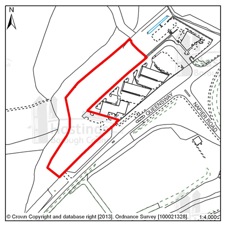
Figure 17: LRA9 - Marline Fields, Enviro21 Business Park, Land West of Queensway
Site address: Marline Fields, Enviro21 Business Park, Land West of Queensway
Allocated use: Employment; B use classes
Area: 1.48ha
Possible floorspace (gross): 5,600m2
6.43 Site LRA9 – Marline Fields, Enviro21 Business Park, Land West of Queensway has the capacity for approximately 5,600m2 of business floor space and is part of a larger site. Four high quality business units and the access spine road have already been constructed under the Enviro21 Business Park scheme. The plots themselves are cleared and prepared. It is therefore effectively a serviced site ready for development, either under the existing planning permission or through a fresh design.
6.44 The site adjoins a Site of Special Scientific Interest and any development would need to ensure that there is minimal ecological impact on the protected site, in particular the hydrological effects on drainage into the Marline Valley stream. There is also some surface water flood risk on the site. The size of the whole site is over 1 hectare so, as advised by the Environment Agency, a Flood Risk Assessment is required. Development proposals will need to show consideration of the transport impact along The Ridge. Further advise on transport matters is available from East Sussex County Council.
(1)
Policy
LRA9 - Marline Fields, Enviro21 Business Park, Land West of
Queensway
Marline Fields, Enviro21 Business Park, Land West of Queensway is allocated for employment (B use classes) development (Possible floorspace (gross): 5,600m2).
The Council expects development proposals for this site to:
-
Include an Ecological Constraints and Opportunities Plan, including specific reference to the presence of the adjacent Site of Special Scientific Interest (SSSI), and incorporate conservation and mitigation measures as recommended by the Plan as appropriate;
-
Include a Flood Risk Assessment and incorporate measures to address surface water flood risk such as Sustainable Drainage Systems;
-
Be supported by a Transport Assesment and Travel Plan. The Transport Assesment will need to take account of the site’s proximity to The Ridge. Proposals should indicate how the conclusions and recommendations of the Assessment have been incorporated. Potentially development may be required to contribute to improvements on The Ridge;
-
Include traffic access improvements from the existing Enviro21 business park (and an additional ‘emergency access’ onto Queensway);
-
Investigate the impact of land stability and contamination and incorporate mitigation measures as appropriate;
-
Be designed to reduce the impact of potential pollution and hazards to site users and its neighbours .
All policies of the Local Plan will be applied, as appropriate, to any scheme presented to the Council.
Focus Area 2: Greater Hollington
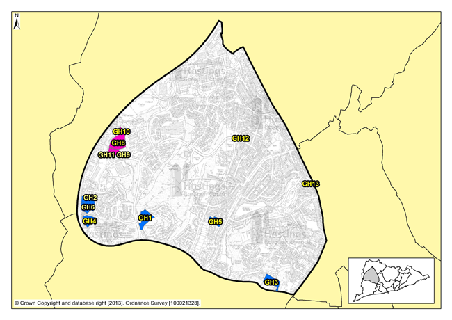
Figure 18: Focus Area 2 - Greater Hollington
Introduction to the Greater Hollington Planning Focus Area
6.45 Lying outside of the main town centres, this Planning Focus Area includes a broad mix of different characteristics and uses, covering housing, factory estates, retail and protected open space. Bordered by Battle Road in the east and the sweeping curve of Queensway in the west, it extends from the Asda superstore at Silverhill to opencountryside on the western edges of town.
6.46 The majority of housing here is post-war, with the Four Courts (Hastings’ only dedicated housing tower blocks) forming a very striking part of the townscape. But there are few flats otherwise. A lot of the housing is family houses with gardens. Much of the housing in this Focus Area is the product of extensive urban growth and expansion projects of the last 30 years. There are, however, occasional pockets of older pre-war cottages that once stood in villages, before Hastings Borough extended across them.
6.47 There are 3 major industrial estates here: Castleham, Churchfields, and Ponswood. These are well-used and provide a significant contribution to local employment, with employers such as General Dynamics, Marshall Tufflex and Deutsch. The town’s largest single retail store is here too, the Tesco Extra superstore on Church Wood Drive. The area is reasonably well served by local convenience stores, has doctors’ surgeries, and community centres.
(1) 6.48 But Greater Hollington is not an unending suburban sprawl of housing and factory estates. There are plenty of open spaces here, and some of the most important ecological habitats in town, notably at Church Wood and the neighbouring Robsack Wood nature reserves. Walking through these ancient woodlands, it feels as though you’re far out in the countryside, not a few hundred metres from shops and factories.
6.49 Even outside of these nature reserves, Greater Hollington has an open, spacious feel. There’s Hollington Park (comprising Ponds wood and Gillsman’s Wood), and many smaller open spaces, allotments, playing fields, and houses with gardens. This sense of space might, though, be somewhat misleading as the population density is relatively high at 68 people per hectare (according to 2001 Census data).
6.50 This Focus Area has the second highest population of the 13, with a high proportion of families with children. Census data shows that more than a fifth of the population are children under 16, and this is possibly indicative of this area being the third highest for the proportion of families with children. There is significant economic deprivation here also. It is the fourth most deprived area of the Borough, with a quarter of the adult population on out-of-work benefits (according to the Department of Work and Pensions – Nomis statistics); more than a third of the children live in families with incomes below the official UK poverty level (Office of National Statistics) and nearly 50% of houses are social rented.
6.51 So this is an area of contrasts: successful businesses and unemployment; high-rise housing and bungalows; factory estates and nature reserves.
Our Vision for Greater Hollington
6.52 We want Greater Hollington to retain its open, spacious environment while remaining as one of the principal employment areas of the town. To achieve this, it will be essential to retain the protected open spaces, parks, allotments and nature reserves between housing and factory estates.
6.53 The architectural heritage of Greater Hollington is rooted in the expansion of Hastings Borough during the second half of the 20th century, and particularly during the last 30 years. So whilst an appreciation of the built environment in this area is important, there are particular opportunities for innovative development here. Over the next 15 years, Policy FA1 of the Planning Strategy sets out a need to plan for 250-310 new homes to be built in this area; there is the scope to provide a range of housing types and tenures with a mix of family homes with gardens, and smaller residences for single people and couples. Schemes for development in Greater Hollington should reflect the spacious feel of the surrounding area and a particular aspect of this should be good design with a focus on environmental efficiency that minimises fuel costs.
6.54 We would especially welcome applications to renovate or redevelop industrial premises, especially in ways that minimise energy consumption and protect natural resources. More retail premises could also be considered, although not big, out-of-town retail supermarkets – rather, smaller shops that serve a more local community. And we would consider proposals to blend the currently quite rigid boundaries between industrial and residential areas, with the possibility of small, modern workshops mixed in with housing, and possibly live/work units. We would not, however, want to see the space allocated for employment purposes in the area reduce overall. Increasing the opportunities for employment is one way to help reduce the numbers of people on out of work benefits.
6.55 Development in Greater Hollington should be attractive, imaginative, and environmentally sustainable. We want to see the area develop as an environmental showcase of innovative design, blending housing and industrial uses into the natural green spaces that will continue to be at the heart of its communities.
Residential, mixed use and other allocations for Greater Hollington
| Site reference | Address |
Reason for allocation (including potential number of homes) |
Area (ha) | Does the site have a brief in Appendix A? |
|---|---|---|---|---|
| GH1 | Robsack A, Church Wood Drive | Residential (32) | 1.24 |
|
| GH2 | Mayfield E, Bodiam Drive | Residential (37) | 1.10 |
|
| GH3 | Spyways School, Gillsmans Hill | Residential (33) | 1.05 |
|
| GH4 | Mayfield J, Mayfield Lane | Residential (36) | 0.77 |
|
| GH5 | Land at Redgeland Rise (Former Wishing Tree Nursery) | Residential (28) | 0.71 |
|
| GH6 | Mayfield Farm | Residential (8) | 0.54 |
|
| GH12 | 63 Wishing Tree Road North (Former Wishing Tree Public House) | Residential (6) | 0.12 |
|
| GH13 | 133 Battle Road (Former Tivoli Tavern) | Residential (11) | 0.10 |
|
Table 3: Residential, mixed use and other allocations for Greater Hollington
Employment allocations for Greater Hollington
| Site reference | Address | Potential gross floorspace (m2) | Area (ha) | Does the site have a brief in Appendix A? |
|---|---|---|---|---|
| GH8 | Sites PX and QX, Churchfields | 6,900 | 1.61 |
|
| GH9 | Site NX2 Sidney Little Road, Churchfields | 770 | 0.32 |
|
| GH10 | Site RX2, Sidney Little Road, Churchfields | 910 | 0.22 |
|
| GH11 | Site NX3 Sidney Little Road, Churchfields | 920 | 0.17 |
|
Table 4: Employment allocations for Greater Hollington
Site reference: GH1 - Robsack A, Church Wood Drive
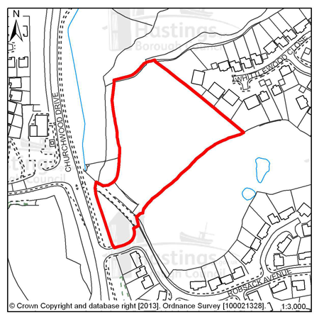
Figure 19: GH1 - Robsack A, Church Wood Drive
Site address: Robsack A, Church Wood Drive
Allocated use: Residential
Area: 1.24ha
Possible net capacity: 32
(7) 6.56 Site GH1 - Robsack A, Church Wood Drive is bounded on its north-western and south-eastern sides by Ancient Woodland, part of the Church Wood and Robsack Wood Local Nature Reserve. A narrow finger of Ancient Woodland also extends into the site near to the western boundary. In order to protect the Ancient Woodland, housing development will be confined to the central part of the site, which is mainly grassland. A native woodland buffer is to be maintained around the development, supplemented in places by new tree and shrub planting. A proportionate financial contribution to the management of the adjacent Local Nature Reserve will be required to mitigate for the loss of semi-natural habitat.
(1) 6.57 Consideration should be given to the amenity of the residents in properties on the north-eastern boundary of the site and this should be designed into proposals for any development. The site is likely to be liable to surface water flood risk and the southern tip of the site falls within flood zone 3 and so any development proposal will need to be accompanied by a Flood Risk Assessment and the proposed scheme should include flood resilient design as appropriate to the assessment. The capacity potential of this site indicates that a Transport Report will be required, further advice is available from East Sussex County Council.
(4) 6.58 The existing field access at the southern end of the site, which forms a narrow gap in the Ancient Woodland, can be enlarged and improved to provide vehicular access to the site. An Arboriculture Implications report concludes that, although eight low value trees are directly affected, no amenity value will be lost and there will be no detrimental impact on the functioning of the Ancient Woodland. The maintenance of a closed canopy over the road will be important in the interests of maintaining wildlife corridors. This will be achieved via the closed canopies of surrounding trees and the Arboriculture Implications Report concludes that the overall loss of canopy will be minor. There will be a break in the canopy but this will be quickly filled by extension growth.
(14)
Policy
GH1 - Robsack A, Church Wood Drive
Robsack A, Church Wood Drive is allocated for residential development (possible net capacity 32 dwellings).
The Council expects development proposals for this site to:
-
(2) Include affordable housing on site at 40% of the overall housing provision;
-
Include an Ecological Constraints and Opportunities Plan, including specific reference to the presence of the Ancient Woodland and the adjacent Local Wildlife Site and Local Nature Reserve, and incorporate conservation and mitigation measures as recommended by the Plan as appropriate;
-
Provide a financial contribution to the management of the Local Nature Reserve and opportunities for natural play within;
-
Provide an arboriculture plan that demonstrates how existing trees on site will be integrated into the development, or how compensation will be made for their loss;
-
(2) Include an access route that has the least possible adverse impact on the Ancient Woodland;
-
Be supported by a Flood Risk Assessment and include flood resilient design as appropriate;
-
Incorporate measures to address surface water flood risk such as Sustainable Drainage Systems;
-
Ensure future access to the existing sewerage infrastructure for maintenance and upsizing purposes as advised by Southern Water (applicants should note that waste water infrastructure crosses the site);
-
Be supported by a Transport Report. Proposals should indicate how the conclusions and recommendations of the Report have been incoporated.
Additional guidance is also given in a design brief for this site in Appendix A.
All policies of the Local Plan will be applied, as appropriate, to any scheme presented to the Council.
Site reference: GH2 - Mayfield E, Bodiam Drive
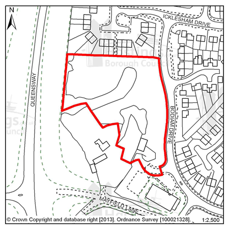
Figure 20: GH2 - Mayfield E, Bodiam Drive
Site address: Mayfield E, Bodiam Drive
Allocated use: Residential Area: 1.10ha
Possible net capacity: 37
6.59 Site GH2 – Mayfield E, Bodiam Drive is a gently sloping site at the edge of an existing residential area, and there is the potential for this site to accommodate at least 37 dwellings. There are opportunities to connect this site to the one directly to its south. This could be by road or footpath and would aid permeability, making it easier for people to travel to and from their homes. There is also a good opportunity to include an access footpath to the existing bus stop on Bodiam Drive at the north-east corner of the site.
6.60 Landscaping and potentially noise screening (hedging for example), is likely to be required along the western border of the site to shield the development from the Queensway road. The capacity potential of this site indicates that a Transport Statement will be required, further advice is available from East Sussex County Council. Any development on this site could potentially affect the setting of Mayfield Farmhouse; a Grade II listed building that is sited immediately to the south-west of the site. The size of the whole site is over 1 hectare, as advised by the Environment Agency, a Flood Risk Assessment is required.
Policy
GH2 - Mayfield E, Bodiam Drive
Mayfield E, Bodiam Drive is allocated for residential development (possible net capacity 37 dwellings).
The Council expects development proposals for this site to:
-
Include affordable housing on site at 40% of the overall housing provision;
-
Sustain and enhance the significance and setting of the Grade II listed Mayfield Farmhouse;
-
Include an Ecological Constraints and Opportunities Plan, including specific reference to the presence of the adjacent Local Wildlife Site, and incorporate conservation and mitigation measures as recommended by the Plan as appropriate;
-
Provide boundary landscaping to act as a buffer from Queensway to the west;
-
Include a Flood Risk Assessment and flood resilient design as appropriate to the outcome of that report;
-
Contribute to the improvement of existing play facilities in the surrounding area;
-
Include walking and cycling links to improve local connectivity;
-
Be supported by a Transport Statement. Proposals should indicate how the conclusions and recommendations of the Statement have been incorporated.
Additional guidance is also given in a design brief for this site in Appendix A.
All policies of the Local Plan will be applied, as appropriate, to any scheme presented to the Council.
Site reference: GH3 - Spyways School, Gillsmans Hill
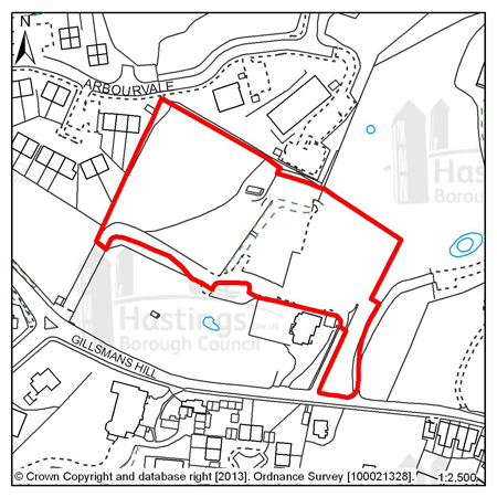
Figure 21: GH3 - Spyways School, Gillsmans Hill
Site address: Spyways School, Gillsmans Hill
Allocated use: Residential
Area: 1.05ha
Possible net capacity: 33
6.61 Site GH3 – Spyways School, Gillsmans Hill is a sloping site from east to west, the west adjoins an existing residential development. The neighbouring residences to the west are bungalows that are largely screened by mature trees. There are a number of protected trees on and adjacent to the site and there is also a Local Wildlife Site that overlaps the area. The size of the whole site is over 1 hectare, as advised by the Environment Agency, a Flood Risk Assessment is required. The capacity potential of this site indicates that a Transport Report will be required, further advice is available from East Sussex County Council.
Policy
GH3 - Spyways School, Gillsmans Hill
Spyways School, Gillsmans Hill is allocated for residential development (possible net capacity 33 dwellings). The Council expects development proposals for this site to:
-
Include affordable housing on site at 25% of the overall housing provision;
-
(1) Include an Ecological Constraints and Opportunities Plan, including specific reference to the presence of the Ancient Woodland and the adjacent Local Nature Reserve, and incorporate conservation and mitigation measures as recommended by the Plan as appropriate;
-
Provide an arboriculture plan that demonstrates how existing trees on site will be integrated into the development, or how compensation will be made for their loss;
-
Include a Flood Risk Assessment and flood resilient design as appropriate to the outcome of that report;
-
Contribute to the improvement of existing play facilities in the surrounding area;
-
Provide a connection to the sewerage system at the nearest point of adequate capacity, as advised by Southern Water;
-
Be supported by a Transport Report. Proposals should indicate how the conclusions and recommendations have been incorporated.
All policies of the Local Plan will be applied, as appropriate, to any scheme presented to the Council.
Site reference: GH4 - Mayfield J, Mayfield Lane
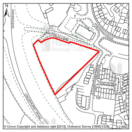
Figure 22: GH4 - Mayfield J, Mayfield Lane
Site address: Mayfield J, Mayfield Lane
Allocated use: Residential
Area: 0.77ha
Possible net capacity: 36
6.62 Site GH4 – Mayfield J, Mayfield Lane is a roughly triangular shaped site between existing residential development and the Queensway road. Formerly part of Mayfield farm it has a well defined boundary of mature vegetation. The capacity potential of this site indicates that a Transport Statement will be required, further advice is available from East Sussex County Council.
(1)
Policy
GH4 - Mayfield J, Mayfield Lane
Mayfield J, Mayfield Lane is allocated for residential development (possible net capacity 36 dwellings).
The Council expects development proposals for this site to:
-
Include affordable housing on site at 40% of the overall housing provision;
-
Include an Ecological Constraints and Opportunities Plan and incorporate conservation and mitigation measures as recommended by the Plan as appropriate;
-
Contribute to the improvement of existing play facilities in the surrounding area;
-
Be supproted by a Transport Statement. Proposals should indicate how the conclusions and recommendations of the Statement have been incorporated.
All policies of the Local Plan will be applied, as appropriate, to any scheme presented to the Council.
Site reference: GH5 - Land at Redgeland Rise (Former Wishing Tree Nursery)
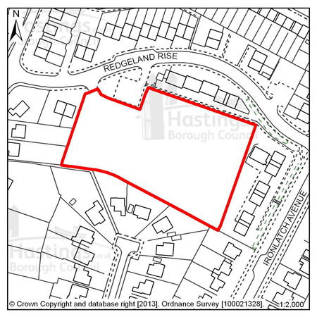
Figure 23: GH5 - Land at Redgeland Rise (Former Wishing Tree Nursery)
Site address: Land at Redgeland Rise (Former Wishing Tree Nursery)
Allocated use: Residential
Area: 0.71ha
Possible net capacity: 28
6.63 Site GH5 – Land at Redgeland Rise (Former Wishing Tree Nursery) was previously occupied by the Hastings Borough Council’s nursery. The site slopes down from west to east. There are a number of trees with Tree Preservation Orders (TPO’s) sited on the western, southern and eastern boundaries, but there is no screening to the north of the site where the flats in Redgeland Rise (Farren Court) face the site. The development to the east in Ironlatch Avenue is at a lower level and to the south of the site are bungalows in Churchwood Way.
6.64 Redgeland Rise is located between designated ecological areas at Hollington Park and Church Wood and there are a number of large gardens to the south of site GH5. It is likely that there will be particular species on site that will need to be carefully managed and other conservation and mitigation measures might be required. The capacity potential of this site indicates that a Transport Report will be required, further advice is available from East Sussex County Council.
Policy
GH5 - Land at Redgeland Rise (Former Wishing Tree Nursery)
Land at Redgeland Rise (Former Wishing Tree Nursery) is allocated for residential development (possible net capacity 28 dwellings).
The Council expects development proposals for this site to:
-
Include affordable housing on site at 25% of the overall housing provision;
-
Include an Ecological Constraints and Opportunities Plan and incorporate conservation and mitigation measures as recommended by the Plan as appropriate;
-
Provide an arboriculture plan that demonstrates how existing trees, particularly at the boundaries of site, will be integrated into the development, or how compensation will be made for their loss;
-
Be supported by a Transport Report. Proposals should indicate how the conclusions and recommendations of the Report have been incoporated.
All policies of the Local Plan will be applied, as appropriate, to any scheme presented to the Council.
Site reference: GH6 - Mayfield Farm, Mayfield Lane
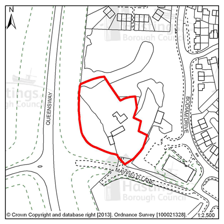
Figure 24: GH6 - Mayfield Farm, Mayfield Lane
Site address: Mayfield Farm, Mayfield Lane
Allocated use: Residential
Area: 0.54ha
Possible net capacity: 8
6.65 Site GH6 – Mayfield Farm, Mayfield Lane is a gently sloping site at the edge of an existing residential area. There is the potential for this site to accommodate about 8 dwellings. Mayfield Farmhouse, a Grade II listed building, is in the centre of this site. Any new development will need to sustain and enhance the setting of the farmhouse.
6.66 The site is adjacent to site GH2 which has a design brief (see Appendix A) that indicates that there are opportunities to connect the two sites, and this should be examined and referenced within any schemes proposed for site GH6.
6.67 New residential development is likely to require the improvement of Mayfield Lane to ensure safe access to the site. Transport management will need to be balanced against the impact of any works on the historic approach to the farmhouse. The capacity potential of this site indicates that a Transport Report will be required, further advice is available from East Sussex County Council. The nearby Landfill site may mean that land contamination needs to be investigated.
Policy
GH6 - Mayfield Farm, Mayfield Lane
Mayfield Farm is allocated for residential development (possible net capacity 8 dwellings).
The Council expects development proposals for this site to:
-
Include affordable housing on site at 40% of the overall housing provision;
-
Sustain and enhance the significance and setting of the Grade II listed Mayfield Farmhouse;
-
Include an Ecological Constraints and Opportunities Plan and incorporate conservation and mitigation measures as recommended by the Plan as appropriate;
-
Contribute to the improvement of existing play facilities in the surrounding area;
-
Include walking and cycling links to improve local connectivity;
-
Provide for the upgrading of Mayfield Lane for access to the development;
-
Investigate the impact of land contamination and incorporate mitigation measures as appropriate.
-
Be supported by a Transport Report. Proposals should indicate how the conclusions and recommendations of the Report have been incoporated.
All policies of the Local Plan will be applied, as appropriate, to any scheme presented to the Council.
Site reference: GH12 – 63 Wishing Tree Road North (Former Wishing Tree Public House)
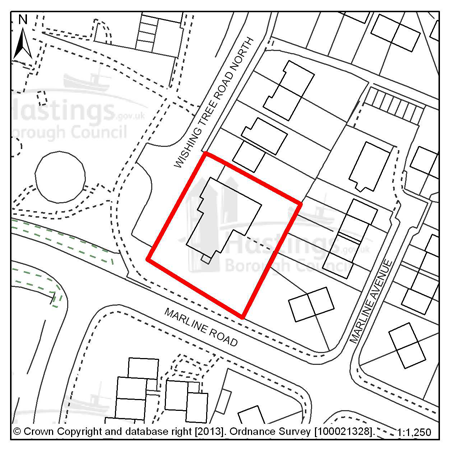
Figure 25: GH12 – 63 Wishing Tree Road North (Former Wishing Tree Public House)
Site address: 63 Wishing Tree Road North (Former Wishing Tree Public House)
Allocated use: Residential
Area: 0.12ha
Possible net capacity: 6
6.68 Site GH12 – 63 Wishing Tree Road North (Former Wishing Tree Public House) is a cleared site in a residential area. The site represents a relatively modest opportunity for redevelopment to result in six new homes. The redevelopment of this site should include the continuation of the footpath in front of the houses to the north. The capacity potential of this site indicates that a Transport Report will be required, further advice is available from East Sussex County Council.
(1)
Policy
GH12 – 63 Wishing Tree Road North (Former Wishing Tree
Public House)
63 Wishing Tree Road North (Former Wishing Tree Public House) is allocated for residential development (possible net capacity 6 dwellings).
The Council expects development proposals for this site to:
-
Include affordable housing on site at 20% of the overall housing provision;
-
Include the continuation of the footpath from the north of the site for the safety of the new occupants and neighbours;
-
>Be supported by a Transport Report. Proposals should indicate how conclusions and recommendations of the Report have been incorporated.
All policies of the Local Plan will be applied, as appropriate, to any scheme presented to the Council.
Site reference: GH13 – 133 Battle Road (Former Tivoli Tavern)
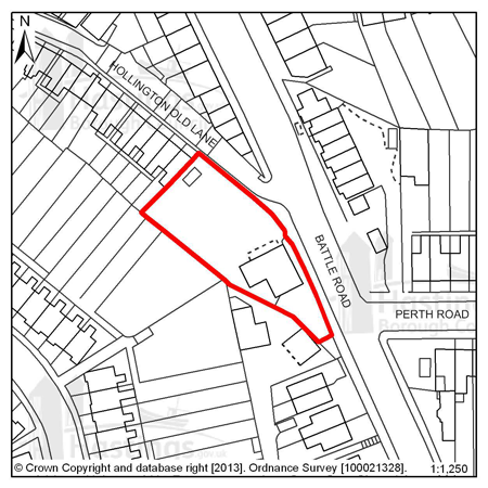
Figure 26: GH13 – 133 Battle Road (Former Tivoli Tavern)
Site address: 133 Battle Road (Former Tivoli Tavern)
Allocated use: Residential
Area: 0.10ha
Possible net capacity: 11
6.69 Site GH13 – 133 Battle Road (Former Tivoli Tavern) is a vacant public house. The site offers an opportunity to redevelop for residential use. This site is adjacent to Battle Road and so access to this will need to be given particular attention for the reasons of safety. The capacity potential of this site indicates that a Transport Report will be required, further advice is available from East Sussex County Council.
(1)
Policy
GH13 – 133 Battle Road (Former Tivoli Tavern)
133 Battle Road (Former Tivoli Tavern) is allocated for residential development (possible net capacity 11 dwellings).
The Council expects development proposals for this site to:
-
Include affordable housing on site at 20% of the overall housing provision;
-
Be supported by a Transport Report. Proposals should indicate how conclusions and recommendations of the Report have been incorporated.
All policies of the Local Plan will be applied, as appropriate, to any scheme presented to the Council.
Site reference: GH8 - Sites PX and QX, Churchfields
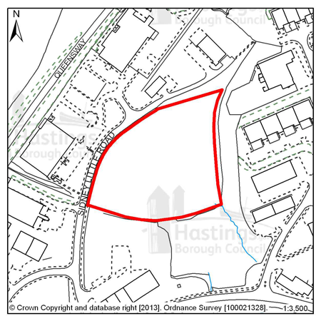
Figure 27: GH8 - Sites PX and QX, Churchfields
Site address: Sites PX and QX, Churchfields Allocated use: Employment; B use classes Area: 1.61ha
Potential floorspace (gross): 6,900m2
6.70 Site GH8 – PX and QX, Churchfields is the largest undeveloped site on the Churchfields Employment Estate.
6.71 This is a sloping site that is largely open, but overgrown with scrub. It is capable of accommodating a single large occupier or, more easily given the topography, several medium sizes units. The long frontage onto Sydney Little Road allows a choice of possible access points.
6.72 Trees along the southern and eastern boundaries should be safeguarded. An ecological survey of the site will be required prior to redevelopment to establish if any protected species are present. The capacity potential of this site indicates that a Transport Assessment and Travel Plan will be required, further advice is available from East Sussex County Council.
Policy
GH8 - Sites PX and QX, Churchfields
PX and QX, Churchfields is allocated for employment (B use classes) development (Possible floorspace (gross): 6,900m2.
The Council expects development proposals for this site to:
-
Include an Ecological Constraints and Opportunities Plan, including specific reference to the presence of the adjacent Ancient Woodland and the nearby Local Wildlife Site, and incorporate conservation and mitigation measures as recommended by the Plan as appropriate;
-
Provide an arboriculture plan that demonstrates how existing trees on site will be integrated into the development, or how compensation will be made for their loss;
-
Investigate the impact of land stability and contamination and incorporate mitigation measures as appropriate;
-
Be designed to reduce the impact of potential pollution and hazards to site users and its neighbours;
-
Be supported by a Transport Assessment and Travel Plan. Proposals should indicate how conclusions and recommendations of the Assessment have been incorporated.
All policies of the Local Plan will be applied, as appropriate, to any scheme presented to the Council.
Site reference: GH9 - Site NX2, Sidney Little Road, Churchfields
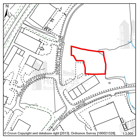
Figure 28: GH9 - Site NX2, Sidney Little Road, Churchfields
Site address: Site NX2, Sidney Little Road, Churchfields
Allocated use: Employment; B use classes
Area: 0.32ha
Potential floorspace (gross): 770m2
6.73 Site GH9 – NX2 Sidney Little Road, Churchfields is one of a group of three small development plots. The first, NX1 immediately to the south, was developed as a row of small business units. The existing access off Sydney Little Road is configured to serve both the existing units and those still to be built on this site, NX2, and on site NX3. This sloping site has well established vegetation on and along its northern edge, which should be retained where practical. As with NX1, the site is suited to a group of small units. The capacity potential of this site indicates that a Transport Report will be required, further advice is available from East Sussex County Council.
Policy
GH9 - Site NX2, Sidney Little Road, Churchfields
Site NX2 Sidney Little Road, Churchfields is allocated for employment (B use classes) development (Possible floorspace (gross): 770m2.
The Council expects development proposals for this site to:
-
Provide an arboriculture plan that demonstrates how existing trees on site will be integrated into the development, or how compensation will be made for their loss;
-
Include an Ecological Constraints and Opportunities Plan and incorporate conservation and mitigation measures as recommended by the plan as appropriate;
-
Be designed to reduce the impact of potential pollution and hazards to site users and its neighbours;
-
Be supported by a Transport Report and Travel Plan. Proposals should indicate how conclusions and recommendations of the Report have been incorporated.
All policies of the Local Plan will be applied, as appropriate, to any scheme presented to the Council.
Site reference: GH10 - Site RX2, Sidney Little Road, Churchfields
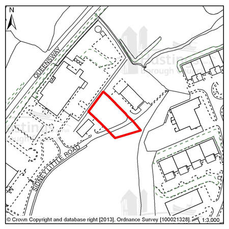
Figure 29: GH10 - Site RX2, Sidney Little Road, Churchfields
Site address: Site RX2, Sidney Little Road, Churchfields
Allocated use: Employment; B use classes
Area: 0.22ha
Potential floorspace (gross): 910m2
6.74 Site GH10 – RX2, Sidney Little Road, Churchfields is a small open site that is the remaining plot of a group of three - the other two having been developed as small/medium business units some time ago.
6.75 A business unit similar in scale to those existing will be acceptable and a shared access with the unit to the north- east would be the most space efficient arrangement. The capacity potential of this site indicates that a Transport Report will be required, further advice is available from East Sussex County Council.
Policy
GH10 - Site RX2, Sidney Little Road, Churchfields
Site RX2, Sidney Little Road, Churchfields is allocated for employment (B use classes) development (Possible floorspace (gross): 910m2.
The Council expects development proposals for this site to:
-
Be designed to reduce the impact of potential pollution and hazards to site users and its neighbours;
-
Include an Ecological Constraints and Opportunities Plan and incorporate conservation and mitigation measures as recommended by the plan as appropriate;
-
Be supported by a Transport Report. Proposals should indicate how conclusions and recommendations of the Report have been incorporated.
All policies of the Local Plan will be applied, as appropriate, to any scheme presented to the Council.
Site reference: GH11 - Site NX3, Sidney Little Road, Churchfields
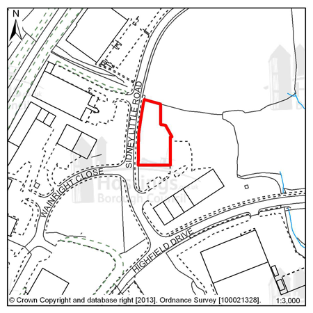
Figure 30: GH11 - Site NX3, Sidney Little Road, Churchfields
Site address: Site NX3, Sidney Little Road, Churchfields
Allocated use: Employment; B use classes
Area: 0.17ha
Potential floorspace (gross): 920m2
6.76 Site GH11 – NX3 Sidney Little Road, Churchfields is one of a group of three small development plots. The first, NX1 immediately to the south, was developed as a row of small business units. The existing access off Sydney Little Road is configured to serve both the existing units, site NX2 and this site, NX3. This sloping site has well established vegetation on and along its northern edge, which should be retained where practical. As with NX1, the site is suited to a group of small units. The capacity potential of this site indicates that a Transport Report will be required, further advice is available from East Sussex County Council.
Policy
GH11 - Site NX3 Sidney Little Road, Churchfields
NX3 Sidney Little Road, Churchfields is allocated for employment (B use classes) development (Possible floorspace (gross): 920m2).
The Council expects development proposals for this site to:
-
Provide an arboriculture plan that demonstrates how existing trees on site will be integrated into the development, or how compensation will be made for their loss;
-
Include an Ecological Constraints and Opportunities Plan and incorporate conservation and mitigation measures as recommended by the plan as appropriate;
-
Be supported by a Transport Report. Proposals should indicate how conclusions and recommendations of the Report have been incorporated.
-
Be designed to reduce the impact of potential pollution and hazards to site users and its neighbours
All policies of the Local Plan will be applied, as appropriate, to any scheme presented to the Council.
Focus Area 3: Filsham Valley & Bulverhythe
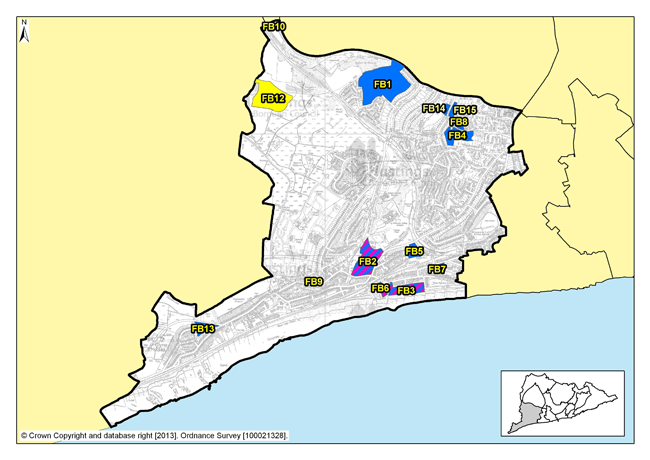
Figure 31: Focus Area 3 - Filsham Valley & Bulverhythe
Introduction to the Filsham Valley & Bulverhythe Planning Focus Area
6.77 Extending from West Marina in the east and Queensway in the north, to the western boundaries of the Borough, this is an area of contrast between 20th Century housing, commercial depots, and wetland nature reserves. When travelling by train from London, this is where visitors get their first impression of Hastings & St Leonards as they glimpse the sea across school playing fields and open spaces that follow the valley to the coast at Bulverhythe.
6.78 The coastal strip was the first part to be developed, along Bexhill Road. Around West Marina Gardens, housing is Victorian and Edwardian, where some of the former grandeur has faded. Recent years have seen a revival however, with much of this housing renovated. Further west, the old bathing pool site remains a development opportunity, alongside the beach chalets here and those at West Haven further along. Beyond this, the housing along Bexhill Road is generally that which was built between the wars. There are industrial areas here too and Brownfield development sites, such as the old West St Leonards school.
6.79 Inland, the housing is more modern, built mostly from the 1930s through to the late 20th Century, the most recent development on a former golf course. East of the Hastings Line railway, the houses are older, larger and mostly detached. This part of the area has a different feel; quieter, more peaceful, an urban fringe with leafy suburban streets in the east to nature reserves to the west, and surrounding countryside. The creation of the St Leonards Academy on the old Filsham Valley school site provides the potential to open the Grove School site as another development opportunity in Filsham Valley & Bulverhythe.
6.80 There are shops scattered through Filsham Valley & Bulverhythe, cafés and takeaways, several larger retail warehouses, a garden centre, car dealers, assorted other commercial premises, and a small community centre. This Focus Area also contains the West St Leonards railway station on the Hastings Line between Ashford in the east and London to the north.
6.81 The beach and coastline here is relatively isolated. Access to it is challenging because it is cut off from the town by the Hastings to Brighton railway line, and to some extent the A259 Bexhill Road. North of Bexhill Road, there are two important wetland nature reserves: South Saxon wetlands and Filsham Reedbeds, within the Combe Haven SSSI. There are playing fields too, and the Combe Haven holiday park, an important source of tourist accommodation.
6.82 According to 2001 Census data, 8,500 people live here and almost 50% of them are over the age of 45; this is higher than the Borough average. It is the third least deprived Focus Area of the 13 (Office of National Statistics). Census data also shows that 80% of the housing in this Focus Area is owner- occupied. The A259, Bexhill Road, dominates the southern part of the Filsham Valley & Bulverhythe Focus Area, but with the completion of the Bexhill-Hastings Link Road and the route options for journeys that this will bring, the congestion along this road should be reduced. Public transport options are good, and the recently completed cycle route along the seafront has created another way for people to reach Bexhill and the beach, so connectivity in this Focus Area is generally good and access to the coastline and beach is improving.
Our Vision for Filsham Valley & Bulverhythe
6.83 Of all the Focus Areas in the Borough, Filsham Valley & Bulverhythe has the potential to see the most change. There are some larger brownfield development opportunity sites here, which could be developed as housing. Policy FA1 of the Planning Strategy identifies that this area has the potential capacity for between 630 and 700 additional homes over the next 15 years. With some of the largest sites in the Borough available here, we would expect to see some innovative and imaginative uses of the land. Higher densities may well be possible, if suitably achieved with perhaps limited flatted developments. But there is a need to retain employment sites, so some existing commercial premises should be kept for employment purposes and their quality and use maintained or improved where possible.
6.84 However, the area is low-lying and parts of it are in a designated ‘flood risk area’. Flood risk, and getting adequate drainage in place, is a significant challenge here.
6.85 When the Bexhill-Hastings Link Road is built, this will make a big difference to Bulverhythe & Filsham Valley, both along Bexhill Road and along Filsham Road. Together with the new cycle path, we would expect to see more people using the beach and sea, and tourists attracted to this area. So there is likely to be the opportunity for more facilities for them close to the beach access points: cafés, small shops, sports, and possibly licensed premises. Consideration may be given to proposals for cafés on the beach side of the railway line. We want this part of the area to come to life, to shake off its ‘edgelands’ feel and reinvent itself. Innovation and imagination offer the potential to help maintain and strengthen the economy and community in this part of the Borough.
6.86 The former bathing pool site at West Marina remains one of the most prominent development sites on Hastings’ seafront. During the next 15 years, we expect this to be developed for both homes and leisure use. Because the site is prominent, potential schemes here would need to pay particular attention to good design and innovation, perhaps something that would be a tourist destination in itself. However, we recognise that it may be a while before such a development is viable, so innovative temporary uses for the site would be encouraged in the meantime.
6.87 The SSSI along Combe Valley will remain protected from development, beyond improved visitor facilities, although these would need to be restrained and environmentally sustainable. And we would want to retain important tourist accommodation at Combe Haven holiday park. Public playing fields and allotments elsewhere in the area will also continue to be protected.
Residential, mixed use and other allocations for Filsham Valley & Bulverhythe
| Site reference | Address |
Reason for allocation (including potential number of homes) |
Area (ha) | Does the site have a brief in Appendix A? |
|---|---|---|---|---|
| FB1 | The Grove School | Residential (240) | 9.40 |
|
| FB2 | Former West St Leonards Primary School | Mixed use (100) | 3.92 |
|
| FB3 | Seaside Road, West St Leonards | Mixed use (120) | 2.22 |
|
| FB4 | Former Westerleigh School | Residential (68) | 2.15 |
|
| FB5 | Former Hastings College, St Saviours Road | Residential (44) | 1.05 |
|
| FB6 | Cinque Ports Way (Former Stamco Timber Yard & TA Centre) | Mixed use (25) | 0.65 |
|
| FB7 | 123-125 West Hill Road (Former Malmesbury House) | Residential (117) | 0.70 |
|
| FB8 | Former Westerleigh School playing fields | Residential (7) | 0.56 |
|
| FB9 | 190 Bexhill Road | Residential (32) | 0.19 |
|
| FB10 | Land south of Crowhurst Road | Permanent site for Gypsies and Travellers (2 pitches) | 0.17 |
|
| FB12 | Land south of Upper Wilting Farm | Wind Turbines | 5.45 |
|
| FB13 | Hastings Garden Centre, Bexhill Road | Residential (12) | 0.78 |
|
| FB14 | Land north of 31 Fern Road | Residential (10) | 0.28 |
|
| FB15 | Land north of 14 Fern Road | Residential (14) | 0.46 |
|
Table 5: Residential, mixed use and other allocations for Filsham Valley & Bulverhythe
Site reference: FB1 - The Grove School
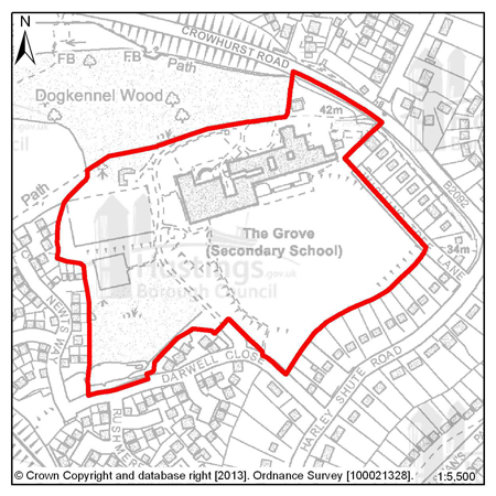
Figure 32: FB1 - The Grove School
Site address: The Grove School
Allocated use: Residential
Area: 9.40ha
Possible net capacity: 240
6.88 Site FB1 – The Grove School has become available for development as it is now considered to be surplus to requirement. The majority of the wooded area in the south-west of the site should be retained and not form part of any redevelopment. A density of 30 dwellings per hectare is assumed and therefore the site could be capable of delivering about 240 units.
6.89 This is a large and relatively level site, in an existing residential area. Its size and location will be expected to support a varied housing mix; to include affordable houses and specific housing for wheelchair users. There is a Multi Use Games Area on site and it retention or relocation must be included in the development proposals.
6.90 Dogkennel Wood to the north-west of the site is an area of Ancient Woodland and this should be conserved, as should existing public footpaths around the site. The County Council’s highway department has commented that the development will require highway junction improvements. The capacity potential of this site indicates that a Transport Assessment and Travel Plan will also be required, further advice is available from East Sussex County Council. Wishing Tree Lane adjacent to the eastern boundary of the site is a privately owned road, if any proposals are to include this road as an access point agreements will have to be made with its owners.
6.91 There are areas of surface water flood risk on the site so the management of drainage will be an important consideration. Given the size of the site the Council expects that applications to develop should include investigations into the capacity of that development to include district heating networks or combined heat and power generation. The size of development might also require the inclusion of local services such as a small convenience store.
(1)
Policy
FB1 - The Grove School
The Grove School is allocated for residential development (possible net capacity 240 dwellings).
The Council expects development proposals for this site to:
-
Include affordable housing on site at 25% of the overall housing provision;
-
Include at least 2% of the total number of new homes as fully adapted dwellings for wheelchair users;
-
Include an Ecological Constraints and Opportunities Plan, including specific reference to the presence of the adjacent Ancient Woodland and Local Wildlife Site, and incorporate conservation and mitigation measures as recommended by the Plan as appropriate;
-
Provide an arboriculture plan that demonstrates how existing trees on site will be integrated into the development, or how compensation will be made for their loss;
-
Include a Flood Risk Assessment and incorporate measures to address surface water flood risk such as Sustainable Drainage Systems;
-
Investigate the feasibility for district heating and/or Combined Heat and Power systems on site;
-
Contribute to the improvement of existing play facilities in the surrounding area;
-
Secure the retention or relocation of the Multi Use Games Area;
-
Include walking and cycling links to improve local connectivity and to preserve the Public Right of Way at the north of the site;
-
Be supported by a Transport Assessment and Travel Plan. Proposals should indicate how the conclusions and recommendations of the Assessment have been incorporated; this is likely to include improved access to the site and to potentially include junction improvements on Harley Shute Road and/ or Crowhurst Road as advised by the Local Highways Authority;
-
Ensure future access to the existing sewerage infrastructure for maintenance and upsizing purposes as advised by Southern Water.
Additional guidance is also given in a design brief for this site in Appendix A.
All policies of the Local Plan will be applied, as appropriate, to any scheme presented to the Council.
Site reference: FB2 – Former West St Leonards Primary School
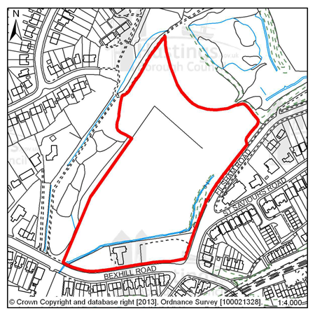
Figure 33: FB2 - Former West St. Leonards Primary School
Site address: Former West St Leonards Primary School
Allocated use: Mixed use (residential and community)
Area: 3.92ha
Possible net capacity: 100
6.92 Site FB2 – Former West St Leonards Primary School is a predominately vacant site that could support at least 100 housing units.
6.93 The Council will expect any development to achieve high standards of sustainable design and construction. There is an area of tidal and fluvial flood risk (Zone 3) on the site and so a Flood Risk Assessment will be required and mitigation as advised by the report should be incorporated into any potential scheme. There is also the potential for surface water flood risk so suitable mitigation should also be included for this.
6.94 This site will be expected to support a housing mix to include affordable housing and specific housing for wheelchair users. All vehicular access will be from Filsham Road. The capacity potential of this site indicates that a Transport Assessment and Travel Plan will be required, further advice is available from East Sussex County Council. Pedestrian/cycle links are proposed to the west and south. A buffer zone is indicated in the design brief (see Appendix A) at the junction of Filsham Road and Bexhill Road to accommodate a bus lane.
6.95 The site adjoins the South Saxons Local Wildlife Site (LWS) to the west and north, and this nature conservation area needs to be safeguarded in the layout of the site. Part of the site was formerly a tip and may still produce landfill gas. There is also a small area of contaminated land in the north-western corner of the site. An assessment of potential contamination will therefore be required. A buffer zone should be maintained on either side of the Hollington Stream in the southern and western parts of the site. The stream is an important ecological asset and is also engineered to avoid unacceptable flood risk so close working with the Council and the Environment Agency is encouraged and opportunities to create a feature of the stream should be explored.
6.96 The Community Hall in the southern part of the site is nearing the end of its useful life and developers will be expected to provide a replacement building. This could be sited adjacent to the existing building.
(1)
Policy
FB2 - Former West St Leonards Primary School
Former West St Leonards Primary School is allocated for mixed use development including residential and community uses (possible net capacity 100 dwellings).
The Council expects development proposals for this site to:
-
Include affordable housing on site at 25% of the overall housing provision;
-
Include at least 2% of the total number of new homes as fully adapted dwellings for wheelchair users;
-
Include an Ecological Constraints and Opportunities Plan, including specific reference to the presence of the adjacent Local Wildlife Site, and incorporate conservation and mitigation measures as recommended by the Plan as appropriate;
-
Provide an arboriculture plan that demonstrates how existing trees on site will be integrated into the development, or how compensation will be made for their loss;
-
Include a Flood Risk Assessment and flood resilient design as appropriate to the outcome of that report;
-
Incorporate measures to address surface water flood risk such as Sustainable Drainage Systems;
-
Provide for the replacement of the Community Hall. The Hall is to be provided prior to the completion of the housing development;
-
Contribute to the improvement of existing play facilities in the surrounding area;
-
Accommodate a bus lane on the Bexhill Road up to the junction with Filsham Road;
-
Be supported by a Transport Assessment and Travel Plan. Proposals should indicate how the conclusions and recommendations of the Assessment have been incorporated;
Additional guidance is also given in a design brief for this site in Appendix A.
All policies of the Local Plan will be applied, as appropriate, to any scheme presented to the Council.
Site reference: FB3 - Seaside Road, West St Leonards
Figure 34: FB3 - Seaside Road, West St Leonards
Site address: Seaside Road, West St Leonards
Allocated use: Mixed use (residential and commercial)
Area: 2.22ha
Possible net capacity: 120
6.97 Site FB3 – Seaside Road, West St Leonards is a vacant brownfield site, and is part of the wider West Marina redevelopment area, which is an area of vacant and under-used land the regeneration of which has been a long term objective of the Council. Previous studies have indicated that this site could support 120 housing units as part of a mix of commercial, leisure and residential uses.
(1) 6.98 Seaside Road is one of the few remaining significant re-development sites on the Hastings/St Leonards seafront. It presents an opportunity to create a high quality development which, with the adjacent Cinque Ports Way site FB6, will both regenerate the area and act as a tourist attraction in its own right, as an addition to Hastings and the Old Town. The site is capable of accommodating both apartments and family housing. The site, given its size and location, will be expected to support a varied housing mix and may be required to include specific housing for wheelchair users, and affordable housing will also be required as part of the mix.
6.99 The Council will expect to see a high quality innovative design with particular regard to sustainability. The Grosvenor Gardens Conservation Area sits immediately to the east of this site. Any new development on this site must sustain and enhance the setting of the conservation area.
6.100 The location, scale and massing of housing units should have regard to the outlook of adjacent properties in Seaside Road and Grosvenor Gardens. Opportunities should be taken where possible to exploit the sea views that the site offers.
6.101 Developers will be expected to create a broad promenade for pedestrians and cyclists behind the seawall running east to west across the site. This should also act as a way of protecting views along the seafront. Improvements to the seawall will be required and the potential for vegetative shingle creation will need to be explored. There is tidal and fluvial flood risk (Zone 3) on the site and so a Flood Risk Assessment will be required and mitigation as advised by the report should be incorporated into any potential scheme.
6.102 The site is considered to be suitable for leisure and recreational uses, particularly those associated with the water. The site could also accommodate small scale kiosk style retail uses normally found at the seaside, a cafeteria and a public house/restaurant. These would be best sited behind the promenade. If possible, new permanent beach huts should be provided to replace the existing ones at the western end of the site. Opportunities for co-ordinating development with site FB6 should also be explored.
6.103 There is an underground tank in the northern part of the site opposite Seaside Way. This cannot be built over and must remain as open land. The eastern part of the site contains filled land and there have been previous commercial uses elsewhere on the site. Developers will be expected to provide an assessment of ground conditions and potential contamination. There is a playground on the site that must be retained or sympathetically relocated. The capacity potential of this site indicates that a Transport Assessment and Travel Plan will be required, further advice is available from East Sussex County Council. Vehicular access is available to Cinque Ports Way, Seaside Road and Grosvenor Gardens, and the management of these accesses and likely road and junction improvements should occur in conjunction with site FB6.
(2)
Policy
FB3 - Seaside Road, West St Leonards
Seaside Road, West St Leonards is allocated for mixed use development including residential and commercial uses (possible net capacity 120 dwellings).
The Council expects development proposals for this site to:
-
Include affordable housing on site at 25% of the overall housing provision;
-
Include at least 2% of the total number of new homes as fully adapted dwellings for wheelchair users;
-
Sustain and enhance the significance and setting of the Grosvenor Gardens Conservation Area;
-
Include a Flood Risk Assessment and flood resilient design as appropriate to the outcome of that report;
-
Incorporate measures to address sea water flood risk to include the continued maintenance of the seawall;
-
Incorporate measures to address surface water flood risk such as Sustainable Drainage Systems;
-
Provide a public realm and promenade that is attractive and inviting to residents and tourists;
-
Retain or relocate the beach huts in the south west of the site
-
Retain open land above the underground tank in the north of the site;
-
Investigate the feasibility for district heating and/or Combined Heat and Power systems on site;
-
Secure the retention or relocation of the playground and contribute towards its maintenance or enhancement;
-
Include walking and cycling links to improve local connectivity and to preserve the cycle route and Public Right of Way at the south of the site;
-
Be supported by a Transport Assessment and Travel Plan. Proposals should indicate how the recommendations and conclusions of the Assessment have been incorporated;
-
Provide a connection to the sewerage system at the nearest point of adequate capacity, as advised by Southern Water and ensure future access to the existing sewerage and water supply infrastructure for maintenance and upsizing purposes;
Additional guidance is also given in a design brief for this site in Appendix A.
All policies of the Local Plan will be applied, as appropriate, to any scheme presented to the Council.
Site reference: FB4 - Former Westerleigh School
Figure 35: FB4 - Former Westerleigh School
Site address: Former Westerleigh School
Allocated use: Residential
Area: 2.15ha
Possible net capacity: 68
6.104 Site FB4 – Former Westerleigh School provides an opportunity for redevelopment since the closure of the private school.
6.105 The slope of the land, the existing mature trees within the site and important nature conservation issues will need to be explored in any scheme that is put forward for this site. The design brief for FB4 in Appendix A shows how a scheme might be able to accommodate development, green space, potential access points and boundary landscaping. At a density of 35 dwellings per hectare and given the areas shown on the brief that are protected, a minimum capacity of 68 dwellings could be achieved.
6.106 The site, given its size and location, will be expected to support a varied housing mix and may be required to include specific housing for wheelchair users, and affordable housing will also be required as part of the mix. Of particular importance for this site will be measures to reduce surface water flood risk, and Sustainable Drainage Systems (SUDs) are likely to be required. Connections between the green space protected on site and those existing green spaces off site will also need to be shown on any application to ensure the conservation and enhancement of the green infrastructure network. The capacity potential of this site indicates that a Transport Statement and Travel Plan Statement will be required, further advice is available from East Sussex County Council.
Policy
FB4 - Former Westerleigh School
Former Westerleigh School is allocated for residential development (possible net capacity 68 dwellings). The Council expects development proposals for this site to:
-
Include affordable housing on site at 25% of the overall housing provision;
-
Include at least 2% of the total number of new homes as fully adapted dwellings for wheelchair users;
-
Include an Ecological Constraints and Opportunities Plan and incorporate conservation and mitigation measures as recommended by the Plan as appropriate;
-
Provide an arboriculture plan that demonstrates how existing trees on site will be integrated into the development, or how compensation will be made for their loss;
-
Include a Flood Risk Assessment and incorporate measures to address surface water flood risk such as Sustainable Drainage Systems;
-
Contribute to the improvement of existing play facilities in the surrounding area;
-
Include walking and cycling links to improve local connectivity and to preserve the Public Right of Way at the north of the site;
-
Be supported by a Transport Statement and Travel Plan Statement. Proposals should indicate how the conclusions and recommendations of the Statement have been incorporated;
-
Provide a connection to the sewerage system at the nearest point of adequate capacity, as advised by Southern Water and ensure future access to the existing sewerage infrastructure for maintenance and upsizing purposes.
Additional guidance is also given in a design brief for this site in Appendix A.
All policies of the Local Plan will be applied, as appropriate, to any scheme presented to the Council.
Site reference: FB5 - Former Hastings College, St Saviours Road
Figure 36: FB5 - Former Hastings College, St Saviours Road
Site address: Former Hastings College, St Saviours Road
Allocated use: Residential Area: 1.05ha
Possible net capacity: 44
6.107 Site FB5 – Former Hastings College, St Saviours Road is bounded by St Vincents Road, Filsham Road and St Saviours Road and currently comprises three and four storey brick built buildings which were most recently occupied by Hastings College prior to their relocation to new premises at Station Plaza. The southern boundary fronts a natural wooded area which slopes down to the railway line with views across to the sea. There are two storey houses immediately adjacent the site in St Vincents Road and St Saviours Road. There are recorded ecological constraints to the site that will require investigation and, as appropriate, conservation or mitigation prior to development. There is some surface water flood risk on site and, following advice from the Environment Agency, because of the size of the site a Flood Risk Assessment will be required. The capacity potential of this site indicates that a Transport Statement will be required, further advice is available from East Sussex County Council.
Policy
FB5 - Former Hastings College, St Saviours Road
Former Hastings College, St Saviours Road is allocated for residential development (possible net capacity 44 dwellings).
The Council expects development proposals for this site to:
-
Include affordable housing on site at 25% of the overall housing provision;
-
Include an Ecological Constraints and Opportunities Plan and incorporate conservation and mitigation measures as recommended by the Plan as appropriate.;
-
Provide an arboriculture plan that demonstrates how existing trees on site will be integrated into the development, or how compensation will be made for their loss;
-
Include a Flood Risk Assessment and flood resilient design as appropriate to the outcome of that report;
-
Contribute to the improvement of existing play facilities in the surrounding area;
-
Be supported by a Transport Statement. Proposals should indicate how the conclusions and recommendations of the Statement have been incorporated;
-
Ensure future access to the existing sewerage infrastructure for maintenance and upsizing purposes as advised by Southern Water.
All policies of the Local Plan will be applied, as appropriate, to any scheme presented to the Council.
Site reference: FB6 - Cinque Ports Way (Former Stamco Timber Yard & TA Centre)
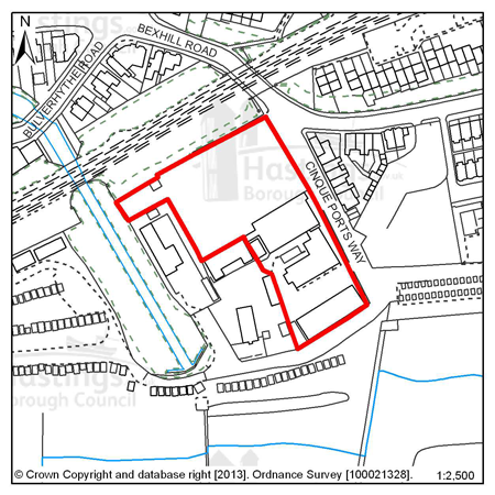
Figure 37: FB6 - Cinque Ports Way (Former Stamco Timber Yard & TA Centre)
Site address: Cinque Ports Way (Former Stamco Timber Yard & TA Centre)
Allocated use: Mixed use (residential and commercial)
Area: 0.65ha
Possible net capacity: 25
6.108 Site FB6 – Cinque Ports Way (Former Stamco Timber Yard & TA Centre) has redevelopment potential for a mix of uses including residential. Its seafront location also gives an opportunity for commercial and tourist development.
6.109 The site is potentially part of the West Marina redevelopment, an area of vacant and under-used land the regeneration of which has been a long term objective of the Council. This site could support 25 housing units as part of a mix of commercial and residential units, and these residences are the minimum for which the site is allocated.
6.110 The design brief for site FB6 (in combination with FB3) – (see Appendix A) – indicates how it might be organised to accommodate both commercial and residential uses. It also shows potential access routes, and the management of these accesses and likely road and junction improvements should occur in conjunction with site FB3. The capacity potential of this site indicates that a Transport Report will be required, further advice is available from East Sussex County Council.
6.111 There is a Public Right of Way (and a National Cycle Route) running along the southern boundary, which it will be important to link to. There is a Local Wildlife Site adjacent to FB6 to the west; and avoidance of harm to it is of high importance and an impact assessment will be required.
6.112 This is a site that is in a flood risk area (from all types of flooding), protection and mitigation measures must be included in any scheme. Sustainable Drainage Systems (SUDs) are likely to be required along with potential contributions to the maintenance of the existing sea defences.
(1)
Policy
FB6 - Cinque Ports Way (Former Stamco Timber Yard & TA
Centre)
Cinque Ports Way (Former Stamco Timber Yard & TA Centre) is allocated for mixed use development including residential and commercial uses (possible net capacity 25 dwellings).
The Council expects development proposals for this site to:
-
Include affordable housing on site at 25% of the overall housing provision;
-
Include an Ecological Constraints and Opportunities Plan, including specific reference to the presence of the adjacent Local Wildlife Site, and incorporate conservation and mitigation measures as recommended by the Plan as appropriate;
-
Provide a public realm and promenade that is attractive and inviting to residents and tourists;
-
Be accompanied by a Flood Risk Assessment and incorporate measures to address flood risk (including the maintenance of the seawall), as appropriate, and also surface water flood risk such as Sustainable Drainage Systems;
-
Contribute to the improvement of existing play facilities in the surrounding area;
-
Be supported by a Transport Report. Proposals should indicate how the conclusions and recommendations of the Report have been incorporated;
-
Include walking and cycling links to improve local connectivity and to preserve the cycle route and Public Right of Way at the south of the site;
-
Ensure future access to the existing sewerage infrastructure for maintenance and upsizing purposes as advised by Southern Water.
Additional guidance is also given in a design brief for this site in Appendix A.
All policies of the Local Plan will be applied, as appropriate, to any scheme presented to the Council.
Site reference: FB7 - 123 - 125 West Hill Road (Former Malmesbury House)
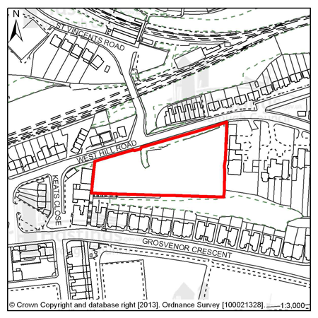
Figure 38: FB7 - 123-125 West Hill Road (Former Malmesbury House)
Site address: 123-125 West Hill Road (Former Malmesbury House)
Allocated use: Residential
Area: 0.70ha
Possible net capacity: 117
6.113 Site FB7–123-125 West Hill Road (Former Malmesbury House) where, in 1989, planning permission was granted for the erection of 117 dwellings in the form of apartment blocks (HS/OA/88/1323). In 2006, a Certificate of Lawful Use was granted stating that this development had commenced within three years of consent being granted and could therefore be completed (HS/PR/05/00980).
6.114 A new scheme would provide an opportunity to incorporate the latest thinking on sustainable design and construction into this site. The possible net capacity of 117 dwellings reflects the existing consent. The capacity potential of this site indicates that a Transport Assessment and Travel Plan will be required, further advice is available from East Sussex County Council.
6.115 The site occupies an elevated prominent location at the western end of the Grosvenor Gardens Conservation Area and is visible from a distance, particularly from the direction of the seafront. Any development should therefore respect longer distance views of the site as well as its immediate surroundings.
6.116 The cliff to the rear of the site is a Local Wildlife Site. Applicants will be required to submit an ecology and arboriculture report. Applicants will also be required to demonstrate that their development will not threaten the stability of the cliff.
(2)
Policy
FB7 - 123 - 125 West Hill Road (Former Malmsbury House)
123 - 125 West Hill Road (Former Malmsbury House) is allocated for residential development (possible net capacity 117 dwellings).
The Council expects development proposals for this site to:
-
Include affordable housing on site at 25% of the overall housing provision;
-
Include at least 2% of the total number of new homes as fully adapted dwellings for wheelchair users;
-
Sustain and enhance the significance and setting of the Grosvenor Gardens Conservation Area;
-
Include an Ecological Constraints and Opportunities Plan, including specific reference to the presence of the adjacent Local Wildlife Site, and incorporate conservation and mitigation measures as recommended by the Plan as appropriate;
-
Be supported by a Transport Assessment and Travel Plan. Proposals should indicate how the conclusions and recommendations of the Assessment have been incorporated;
-
Investigate the impact of land stability and incorporate mitigation measures as appropriate;
-
Provide a connection to the sewerage system at the nearest point of adequate capacity, as advised by Southern Water and ensure future access to the existing sewerage and water supply infrastructure for maintenance and upsizing purposes.
All policies of the Local Plan will be applied, as appropriate, to any scheme presented to the Council.
Site reference: FB8 - Former Westerleigh School, Playing Fields
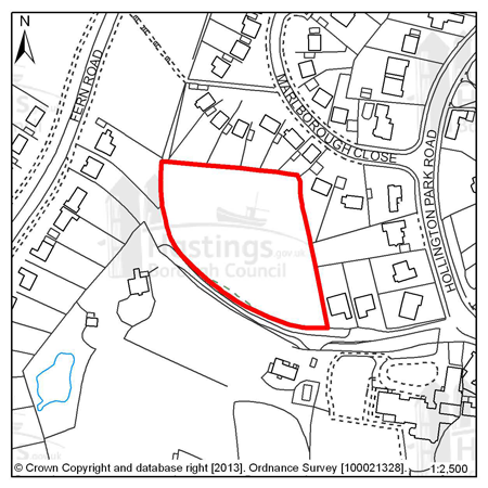
Figure 39: FB8 - Former Westerleigh School, Playing fields
Site address: Former Westerleigh School, Playing Fields
Allocated use: Residential
Area: 0.56ha
Possible net capacity: 7
6.117 Site FB8 – Former Westerleigh School, Playing Fields is across a narrow road from the main former school site (allocated site FB4). It is almost completely surrounded by residential properties and is a relatively flat and open Greenfield site. The capacity potential of this site indicates that a Transport Report will be required, further advice is available from East Sussex County Council.
Policy
FB8 - Former Westerleigh School, Playing Fields
Former Westerleigh School, Playing Fields is allocated for residential development (possible net capacity 7 dwellings).
The Council expects development proposals for this site to:
-
Include Affordable Housing on site at 20% of the overall housing provision;
-
Include an Ecological Constraints and Opportunities Plan and incorporate conservation and mitigation measures as recommended by the Plan as appropriate;
-
Provide an arboriculture plan that demonstrates how existing trees on site will be integrated into the development, or how compensation will be made for their loss.
-
Be supported by a Transport Report. Proposals should indicate how the conclusions and recommendations of the Report have been incorporated.
All policies of the Local Plan will be applied, as appropriate, to any scheme presented to the Council.
Site reference: FB9 - 190 Bexhill Road
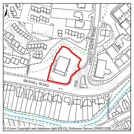
Figure 40: FB9 - 190 Bexhill Road
Site address: 190 Bexhill Road
Allocated use: Residential
Area: 0.19ha
Possible net capacity: 32
6.118 Site FB9 – 190 Bexhill Road is on the junction of Harley Shute Road and Bexhill Road. It is a relatively flat site that is excavated from the cliff behind and is currently used for a retail premises. Just to the south of the site is an area of flood risk that might impact upon the site and in order to avoid any adverse impacts, a Flood Risk Assessment will be required. The capacity potential of this site indicates that a Transport Report will be required, further advice is available from East Sussex County Council.
(1)
Policy
FB9 - 190 Bexhill Road
190 Bexhill Road is allocated for residential development (possible net capacity 32 dwellings).
The Council expects development proposals for this site to:
-
Include affordable housing on site at 25% of the overall housing provision;
-
Include a Flood Risk Assessment and flood resilient design as appropriate to the outcome of that report;
-
Investigate the impact of land stability and incorporate mitigation measures as appropriate. Applicants will be required to demonstrate that their development will not threaten the stability of the cliff;
-
Be supported by a Transport Report. Proposals should indicate how the conclusions and recommendations of the Report have been incorporated.
All policies of the Local Plan will be applied, as appropriate, to any scheme presented to the Council.
Site reference: FB10 - Land south of Crowhurst Road
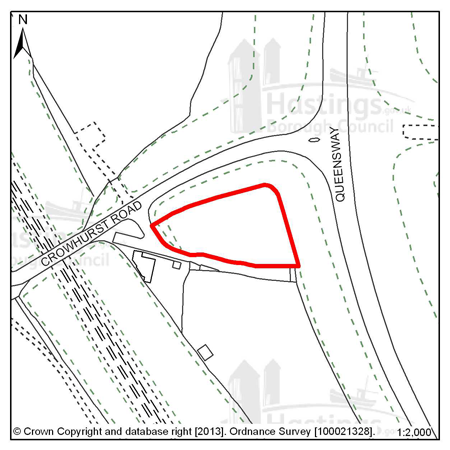
Figure 41: FB10 - Land south of Crowhurst Road
Site address: Land south of Crowhurst Road
Allocated use: Permanent site for Gypsies and Travellers
Area: 0.17ha
Possible net capacity: 2 pitches
6.119 Site FB10 – Land south of Crowhurst Road is a small site that is near to the Queensway, and the Queensway has connections to the wider road network. Access onto the site will need to be improved, but there is enough space to accommodate two permanent residential pitches for gypsies and travellers and ancillary buildings on site.
6.120 The site has a good tree belt at its perimeters, and the Council would wish to see this retained as far as is practicable. The site is also close to sensitive ecological areas, so any potential scheme should demonstrate an understanding of any potential impact and how any adverse impact is avoided or mitigated as appropriate.
(1) 6.121 The Provision of Permanent sites for Gypsies, Travellers and Travelling Showpeople paper (Oct. 2012) indicates that, up to 2016, there is a present need for two permanent pitches. Site FB10 meets this requirement. The Council, along with local partners (including East Sussex County Council, Rother District Council and other relevant stakeholders) will continue to monitor and review the needs of the Gypsy, Traveller and Travelling Showpeople communities. The findings of relevant reports will be published and sites, as appropriate, will be identified as having the potential to accommodate those needs. The assessment criteria for potential sites are included in policy H5 of the Planning Strategy and the general policies of this Plan.
Policy
FB10 - Land south of Crowhurst Road
Land south of Crowhurst Road, is allocated for a permanent site for Gypsies and Travellers (possible net capacity 2 pitches).
The Council expects development proposals for this site to:
-
Include an Ecological Constraints and Opportunities Plan, including specific reference to the presence of the nearby Ancient Woodland and Local Wildlife Site, and incorporate conservation and mitigation measures as recommended by the Plan as appropriate;
-
Provide an arboriculture plan that demonstrates how existing trees on site will be integrated into the development, or how compensation will be made for their loss;
-
Include improvements to the access and the junction of Crowhurst Road and the Queensway as advised by the local Highways Authority (East Sussex County Council).
All policies of the Local Plan will be applied, as appropriate, to any scheme presented to the Council.
Site reference: FB12 - Land south of Upper Wilting Farm
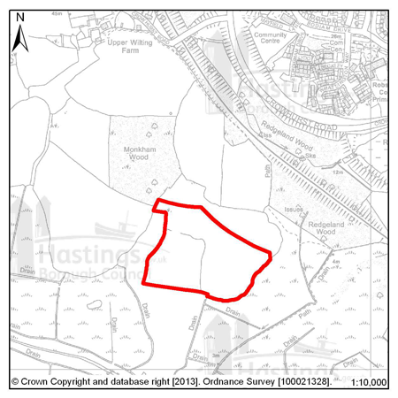
Figure 42: FB12 - Land south of Upper Wilting Farm
Site address: Land south of Upper Wilting Farm
Allocated use: Wind turbine(s)
Area: 5.45ha
(1) 6.122 In order to achieve the aims of off-setting the increased carbon emissions created by further development and to help meet the increased demands for power the Council has identified site FB12 as a site capable of accommodating wind turbines.
(1) 6.123 A study undertaken by Element Energy Ltd has indicated that there are some possible sites in and on the outskirts of the town where wind power could be harnessed. This site in the west of the Borough at the edge of the Combe Valley Countryside Park was identified as one that was at a distance from buildings, power lines and areas of particular environmental protection where it might be possible to site wind turbines.
(1) 6.124 The Council commissioned further investigative work on the feasibility of this site for wind turbines, in ecological, landscape, heritage and viability terms. The conclusion of this work is that the construction of wind turbines in this location is feasible subject to further survey, conservation and mitigation work at the time of a planning application. It should also be noted that there is a small flood risk in the south of the site and any application should reflect this fact.
(10)
Policy
FB12 - Land south of Upper Wilting Farm
Land south of Upper Wilting Farm is allocated for the development of wind turbines. The Council expects development proposals for this site to:
-
Include a Historic Environment Record (HER) informed desk-based assessment of potential interest within an archaeological notification area and agree to a ‘watching brief’ during any development works (as advised by East Sussex County Council);
-
Include an Ecological Constraints and Opportunities Plan, including specific reference to the presence of:
-
The Combe Haven Valley Site of Special Scientific Interest (SSSI)
-
Combe Valley Countryside Park
-
Ancient Woodlands
-
Local Wildlife Sites
-
(All as shown on the policies map)
And, incorporate conservation and mitigation measures as recommended by the Plan as appropriate
-
Provide an arboriculture plan that demonstrates how existing trees on site will be integrated into the development, or how compensation will be made for their loss;
-
Include a Landscape Assessment, providing an appraisal of the impact to the wider landscape (including the Area of Outstanding Natural Beauty) and demonstrate how adverse impact will be avoided;
-
Include a Flood Risk Assessment and flood resilient design as appropriate to the outcome of that report;
-
Avoid interruption to other utility providers (for example telecommunications);
-
Include an access point to the site that is useable for construction and maintenance traffic.
All policies of the Local Plan will be applied, as appropriate, to any scheme presented to the Council.
Site reference: FB13 - Hastings Garden Centre, Bexhill Road
Figure 43: FB13 - Hastings Garden Centre, Bexhill Road
Site address: Hastings Garden Centre, Bexhill Road
Allocated use: Residential
Area: 0.78ha
Possible net capacity: 12
6.125 Site FB13 – Hastings Garden Centre, Bexhill Road. An earlier assessment found that there was an unacceptable flood risk on the site, but following new modelling work from the Environment Agency this risk has been much reduced. There is still a small area of the site in Flood Zone 2 so a Flood Risk Assessment will be required, however, the site would be acceptable as a Brownfield redevelopment.
6.126 The site is located close to the Combe Valley Countryside Park and new play facilities, so proposals for the site will need to take these into account. It also falls within an Archaeological Notification Area so Proposals will be referred to the East Sussex County Council and, in consultation with the County Archaeologist, further investigation works and/or conservation may be required. The capacity potential of this site indicates that a Transport Report will be required, further advice is available from East Sussex County Council.
(2)
Policy
FB13 - Hastings Garden Centre, Bexhill Road
Hastings Garden Centre, Bexhill Road is allocated for residential development (possible net capacity 12 dwellings).
The Council expects development proposals for this site to:
-
Include affordable housing on site at 25% of the overall housing provision;
-
Include an Ecological Constraints and Opportunities Plan, including specific reference to the adjacent Coombe Valley Countryside Park, and incorporate conservation and mitigation measures as recommended by the Plan as appropriate;
-
Provide a financial contribution to local green space management and play provision;
-
Include a Historic Environment Record (HER) informed desk-based assessment of potential interest within an Archaeological Notification Area and agree a ‘watching brief’ during any development works (as advised by East Sussex County Council).
-
Include a Flood Risk Assessment and flood resilient design as appropriate to the outcome of that report
-
Be supported by a Transport Report. Proposals should indicate how the conclusions and recommendations of the Report have been incorporated.
All policies of the Local Plan will be applied, as appropriate, to any scheme presented to the Council.
Site reference: FB14 - Land north of 31 Fern Road
Figure 44: FB14 - Land north of 31 Fern Road
Site address: Land north of 31 Fern Road
Allocated use: Residential
Area: 0.28ha
Possible net capacity: 10
6.127 Site FB14 - Land north of 31 Fern Road is undeveloped land between existing residential developments. Development of this site would represent an acceptable continuation of the street scene. The site is within a Local Wildlife Site and adjacent to a newly designated Local Nature Reserve, so proposals for the site will need to be sympathetic to this and avoid adverse impacts as far as is possible. The capacity potential of this site indicates that a Transport Report will be required, further advice is available from East Sussex County Council.
(2)
Policy
FB14 - Land north of 31 Fern Road
Land North of 31 Fern Road is allocated for residential development (possible net capacity 10 dwellings).
The Council expects development proposals for this site to:
-
Include affordable housing on site at 40% of the overall housing provision;
-
Include an Ecological Constraints and Opportunities Plan, including specific reference to the presence of the Local Wildlife Site and adjacent Local Nature Reserve, and incorporate conservation and mitigation measures as recommended by the Plan as appropriate;
-
Provide a financial contribution to the management of the Local Nature Reserve;
-
Be supported by a Transport Report. Proposals should indicate how the conclusions and recommendations of the Report have been incorporated.
All policies of the Local Plan will be applied, as appropriate, to any scheme presented to the Council.
Site reference: FB15 - Land north of 14 Fern Road
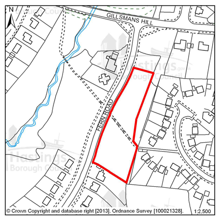
Figure 45: FB15 - Land north of 14 Fern Road
Site address: Land north of 14 Fern Road
Allocated use: Residential
Area: 0.46ha
Possible net capacity: 14
6.128 Site FB15 - Land north of 14 Fern Road is undeveloped land next to existing residential developments. Development of this site would represent an acceptable continuation of the street scene. The site is across the road from a Local Wildlife Site and a newly designated Local Nature Reserve, so proposals for the site will need to be sympathetic to this and avoid adverse impacts as far as is possible. The capacity potential of this site indicates that a Transport Report will be required, further advice is available from East Sussex County Council.
(2)
Policy
FB15 - Land north of 14 Fern Road
Land North of 14 Fern Road is allocated for residential development (possible net capacity 14 dwellings).
The Council expects development proposals for this site to:
-
Include affordable housing on site at 40% of the overall housing provision;
-
Include an Ecological Constraints and Opportunities Plan, including specific reference to the presence of the Local Wildlife Site and adjacent Local Nature Reserve, and incorporate conservation and mitigation measures as recommended by the Plan as appropriate;
-
Provide a financial contribution to the management of the Local Nature Reserve;
-
Be supported by a Transport Report. Proposals should indicate how the conclusions and recommendations of the Report have been incorporated.
All policies of the Local Plan will be applied, as appropriate, to any scheme presented to the Council.
Focus Area 4: St Helens
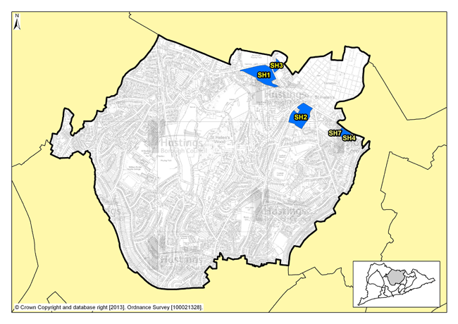
Figure 46: Focus Area 4 - St Helens
Introduction to the St Helens Planning Focus Area
6.129 This Focus Area is dominated by St Helen’s Wood, a local nature reserve with meadowland, woodlands, ponds and streams. To the northern end, St Helen’s Wood joins with playing fields and open spaces at The Ridge and out to the High Weald countryside beyond. The St Helens Focus Area stretches from Parker Road in the east to the Conquest Hospital, and from St Helen’s Road in the south up to the northern edge of the Borough at The Ridge.
6.130 Housing in St Helens is mostly 20th Century post war, although there are Victorian terraces and larger 19th Century detached homes in the south east of the area. Elsewhere, there are a few older houses that were once more rural homes that have been overtaken by Hastings’ expansion. This is a Focus Area where there is another very eclectic range of homes and architectural styles. Around St Helen’s Wood Nature Reserve there are individually designed homes, with large, often wooded gardens. Away from the woods some of the housing is more modest.
6.131 Although this is primarily a residential area, St Helens is also home to the Ark William Parker Acadamy. There is also the cemetery and crematorium, Hastings United football stadium at the Pilot Field, the Firs former football ground, and various playing fields and allotments. St Helens is less well served by shops and employment than other Focus Areas, with most services being just over the borders into other areas. There are some individual shops, pubs and facilities but residents of St Helens often have to travel to get to their jobs and the services they need, with 2001 Census data suggesting car ownership in this area is high, which reflects this fact.
6.132 This is one of the most populous of our Focus Areas, with 11,000 inhabitants, although it is also one of the largest by area. It is the second least deprived part of the Borough (ONS), and 78% of the homes are owner-occupied (according to census data). The population here is older than the Borough average, with more than a third above retirement age, the second highest in the Borough (2001 Census).
Our Vision for St Helens
6.133 The Planning Strategy sets out the requirement for 210-250 new homes to be built in the next 15 years; with most potential development opportunities on Elphinstone Road and The Ridge. Where new development does occur, we would expect it to be in keeping with the suburban and semi-rural nature of the area. Densities of new developments are likely to be higher than current low-density housing. Small flatted developments could be acceptable, with a mix of designs to include houses with gardens where appropriate. Social rented and affordable housing would also be encouraged here, as there’s currently little of it in this area.
6.134 In order to maintain and enhance the communities here, opportunities for mixed use development to include local services could be investigated and the inclusion of live/work units may be appropriate. We will encourage the retention of existing employment land in St Helens that is at a premium. Development proposals, particularly along The Ridge, will need to show consideration of the traffic impact onto and off locally important traffic routes.
6.135 St Helen’s Wood nature reserve will remain protected from development. Any development at the edge of St Helen’s Wood will need to be particularly sympathetic to the character of the reserve, and schemes should aim to preserve views and access to the undeveloped wooded edges. Development proposals on the main roads, and particularly The Ridge, will need to appreciate their potential impact on traffic locally, especially when the new Bexhill-Hastings Link Road is built and new regular routes through the Borough are established.
Residential, mixed use and other allocations for St Helens
| Site reference | Address | Reason for allocation (including potential number of homes) | Area (ha) | Does the site have a brief in Appendix A? |
|---|---|---|---|---|
| SH1 | Land adjacent to Sandrock Park, The Ridge | Residential (80) | 3.32 |
|
| SH2 | Land at Osborne House, The Ridge | Residential (55) | 2.80 |
|
| SH3 | Hurst Court, The Ridge | Residential (20) | 0.66 |
|
| SH4 | Mount Denys, Pinehill & Ridgeway | Residential (31) | 0.64 |
|
| SH7 | 191 The Ridge | Residential (8) | 0.15 |
|
Table 6: Residential, mixed use and other allocations for St Helens
Site reference: SH1 - Land adjacent to Sandrock Park, The Ridge
Figure 47: SH1 - Land adjacent to Sandrock Park, The Ridge
Site address: Land adjacent to Sandrock
Park, The Ridge
Allocated use: Residential
Area: 3.32ha
Possible net capacity: 80
6.136 Site SH1 – Land adjacent to Sandrock Park, The Ridge is a relatively flat triangular site. The western part of the site is unused and the eastern part is a playing field which is under-used.
6.137 There is a tree screen along the frontage with The Ridge. The existing boundary trees are the most significant landscape characteristic of the area, and would need to be managed as part of any development. Retention and management of the existing trees and hedges would be the primary means of mitigation. A new access would be required. Development proposals will need to show consideration of the transport impact along The Ridge. Further advice on transport matters is available from East Sussex County Council. The site is also within an Archaeological Notification Area. The size of the whole site is over 1 hectare, as advised by the Environment Agency, a Flood Risk Assessment is required.
6.138 The site is between protected green spaces – St. Helen’s Wood Local Wildlife Site to the south and the Sandhurst recreation ground across The Ridge to the north, so it will be important that any scheme that is proposed clearly shows how links in the green infrastructure network will be retained. This could be achieved through retaining trees, pathways including a Public Right of Way and some open space which can also be used for informal recreation. The site will also required to make a contribution to the playing fields opposite and existing play facilities in the surrounding area.
6.139 The Ore Place Conservation Area covers a small part of the site in the south east, so development must sustain and enhance the significance and setting of this heritage asset. The site has no existing sewerage capacity and will require a connection to the network. The size of this site means that plans should include a good mix of housing types including affordable housing and they may also be required to include specific housing for wheelchair users.
(2)
Policy
SH1 - Land adjacent to Sandrock Park, The Ridge
Land adjacent to Sandrock Park, The Ridge is allocated for residential development (possible net capacity 80 dwellings).
The Council expects development proposals for this site to:
- Include affordable housing on site at 40% of the overall housing provision;
- Include at least 2% of the total number of new homes as fully adapted dwellings for wheelchair users;
- Sustain and enhance the significance and setting of the Ore Place Conservation Area;
- Include a Historic Environment Record (HER) informed desk-based assessment of potential interest within an archaeological notification area and agree to a ‘watching brief’ during any development works (as advised by East Sussex County Council);
- Include an Ecological Constraints and Opportunities Plan, including specific reference to the presence of the nearby Local Nature Reserve and Local Wildlife Site, and incorporate conservation and mitigation measures as recommended by the Plan as appropriate;
- Provide new green space within the site and retain and enhance boundary landscaping to act as a buffer to surrounding development and The Ridge;
- Provide an arboriculture plan that demonstrates how existing trees on site will be integrated into the development, or how compensation will be made for their loss;
- Include a Flood Risk Assessment and flood resilient design as appropriate to the outcome of that report;
- Provide a contribution towards the improvement and management of the Sandhurst recreation ground;
- Contribute to the improvement of existing play facilities in the surrounding area;
- Include walking and cycling links to improve local connectivity and to preserve the Public Right of Way in the south of the site;
- Be supported by a Transport Statement and Travel Plan. The Transport Statement will need to take account of the site’s proximity to The Ridge. Proposals should indicate how the conclusions and recommendations of the Statement have been incorporated. This is likely to require improved access to the site and to potentially include improvements on The Ridge as advised by the Local Highway Authority;
- To provide a connection to the sewerage system at the nearest point of adequate capacity, as advised by Southern Water and ensure future access to the existing water supply infrastructure for maintenance and upsizing purposes.
Additional guidance is also given in a design brief for this site in Appendix A.
All policies of the Local Plan will be applied, as appropriate, to any scheme presented to the Council.
Site reference: SH2 - Land at Osborne House, The Ridge
Figure 48: SH2 - Land at Osborne House, The Ridge
Site address: Land at Osborne House, The
Ridge
Allocated use: Residential
Area: 2.80ha
Possible net capacity: 55
6.140 Site SH2 – Land at Osborne House, The Ridge had been host to a substantial Victorian property as well as a number of substantial outbuildings set within extensive grounds. The grounds are terraced because the terrain falls away significantly south of The Ridge. There are recorded ecological constraints on this site and because the size of the site is over 1 hectare, as advised by the Environment Agency, a Flood Risk Assessment is required. Development proposals will need to show consideration of the transport impact along The Ridge. Further advice on transport matters is available from East Sussex County Council.
6.141 The site is within an Archaeological Notification Area so any proposals put to the Council will be referred to East Sussex County Council and, in consultation with the County Archaeologist, further investigation works and/or conservation may be required.
(2)
Policy
SH2 - Land at Osborne House, The Ridge
Land at Osborne House, The Ridge is allocated for residential development (possible net capacity 55 dwellings).
The Council expects development proposals for this site to:
- Include affordable housing on site at 25% of the overall housing provision;
- Include an Ecological Constraints and Opportunities Plan and incorporate conservation and mitigation measures as recommended by the Plan as appropriate;
- Provide new green space within the site;
- Provide an arboriculture plan that demonstrates how existing trees on site will be integrated into the development, or how compensation will be made for their loss;
- Include a Historic Environment Record (HER) desk-based assessment of potential interest within an archaeological notification area and agree to a ‘watching brief’ during any development works (as advised by East Sussex County Council);
- Include a Flood Risk Assessment and flood resilient design as appropriate to the outcome of that report;
- Be supported by a Transport Statement and Travel Plan Statement. The Transport Statement will need to take account of the site’s proximity to The Ridge. Proposals should indicate how the conclusions and recommendations of the Statement have been incorporated. Potentially development may be required to contribute to improvements on The Ridge;
- To provide a connection to the sewerage system at the nearest point of adequate capacity, as advised by Southern Water.
All policies of the Local Plan will be applied, as appropriate, to any scheme presented to the Council.
Site reference: SH3 - Hurst Court, The Ridge
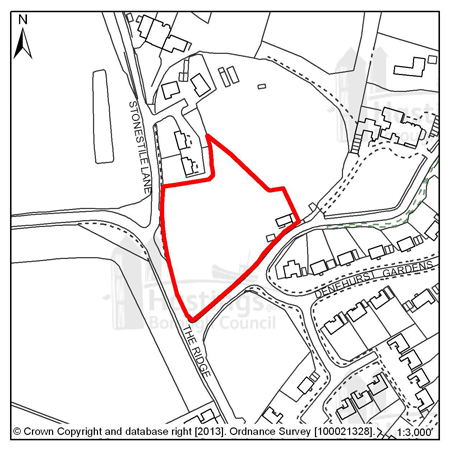
Figure 49: SH3 - Hurst Court, The Ridge
Site address: Hurst Court, The Ridge
Allocated use: Residential
Area: 0.66ha
Possible net capacity: 20
(1) 6.142 Site SH3 – Hurst Court, The Ridge is part of an area where some residential development has begun. It is a relatively level site adjacent to The Ridge on a prominent corner.
6.143 Wildlife and tree cover are likely to affect the developable area of the site. It is therefore required that any potential scheme includes detailed ecological studies and that measures are put in place to protect the ecology. This site commands a prominent position on The Ridge, so any development that faces onto the road will need to be of sufficient quality and proportion to occupy such a place. Development will be expected to support a varied housing mix including affordable housing. Development proposals will need to show consideration of the transport impact along The Ridge. Further advice on transport matters is available from East Sussex County Council.
6.144 This site is within an Archaeological Notification Area so any proposals put to the Council will be referred to East Sussex County Council and, in consultation with the County Archaeologist, further investigation works and/or conservation may be required.
6.145 It will be important that any scheme that is proposed clearly shows how links in the green infrastructure network will be retained. Given the potential size of the development and its proximity to the Sandhurst recreation ground, any development will be expected to contribute to the enhancement of that facility.
(2)
Policy
SH3 - Hurst Court, The Ridge
Hurst Court, The Ridge is allocated for residential development (possible net capacity 20 dwellings).
The Council expects development proposals for this site to:
- Include affordable housing on site at 25% of the overall housing provision;
- Include an Ecological Constraints and Opportunities Plan and incorporate conservation and mitigation measures as recommended by the Plan as appropriate;
- Provide new green space within the site;
- Provide an arboriculture plan that demonstrates how existing trees on site will be integrated into the development, or how compensation will be made for their loss;
- Provide a contribution towards the improvement and management of the Sandhurst recreation ground;
- Contribute to the improvement of existing play facilities in the surrounding area;
- Be supported by a Transport Report. The Report will need to take account of the site’s proximity to The Ridge. Proposals should indicate how the conclusions and recommendations of the Report have been incorporated. This is likely to require access from Stonestile Lane. Potentially development may be required to contribute to improvements on The Ridge.
- To provide a connection to the sewerage system at the nearest point of adequate capacity, as advised by Southern Water;
- Include a Historic Environment Record (HER) desk-based assessment of potential interest within an Archaeological Notification Area and agree to a ‘watching brief’ during any development works (as advised by East Sussex County Council).
Additional guidance is also given in a design brief for this site in Appendix A.
All policies of the Local Plan will be applied, as appropriate, to any scheme presented to the Council.
Site reference: SH4 - Mount Denys, Pinehill & Ridgeway
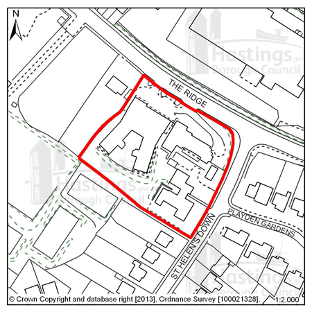
Figure 50: SH4 - Mount Denys, Pinehill & Ridgeway
Site address: Mount Denys, Pinehill &
Ridgeway
Allocated use: Residential
Area: 0.64ha
Possible net capacity: 31
6.146 Site SH4 – Mount Denys, Pinehill & Ridgeway contains buildings that are currently used by East Sussex County Council Social Services. These are likely to become vacant during the Plan period.
6.147 Given the existing character of the surrounding area, the site is suitable for a high density development with a suggested capacity of 31 dwellings. This site will be expected to support a varied housing mix, including affordable housing.
6.148 The site already has some boundary treatment against The Ridge that includes grass and trees; retaining and reinforcing this should be part of any scheme submitted. East Sussex County Council has advised that increasing the amount of traffic that directly accesses The Ridge should be avoided with the main access to the site from St Helen’s Down. The County Council has also suggested that improvements might be required to the junction of The Ridge and St Helen’s Down to accommodate redevelopment on this site. Proposals for this site will need to include a Transport Report, especially because of its proximity to The Ridge. Further advice on transport matters is available from East Sussex County Council.
6.149 This site is within an Archaeological Notification Area, so any proposals put to the Council will be referred to East Sussex County Council and, in consultation with the County Archaeologist, further investigation works and/or conservation may be required.
6.150 The design brief for this site (see in Appendix A) highlights the access and road improvement issues and that there are some green spaces that could be retained.
(1)
Policy
SH4 - Mount Denys, Pinehill & Ridgeway
Mount Denys, Pinehill & Ridgeway is allocated for residential development (possible net capacity 31 dwellings).
The Council expects development proposals for this site to:
- Include affordable housing on site at 25% of the overall housing provision;
- Provide an arboriculture plan that demonstrates how existing trees on site will be integrated into the development, or how compensation will be made for their loss;
- Be supported by a Transport Report. The Report will need to take account of the site’s proximity to The Ridge. Proposals should indicate how the conclusions and recommendations of the Report have been incorporated and this is likely to include junction improvements on The Ridge;
- Provide a connection to the sewerage system at the nearest point of adequate capacity, as advised by Southern Water;
- Include a Historic Environment Record (HER) desk-based assessment of potential interest within an Archaeological Notification Area and agree to a ‘watching brief’ during any development works (as advised by East Sussex County Council).
Additional guidance is also given in a design brief for this site in Appendix A.
All policies of the Local Plan will be applied, as appropriate, to any scheme presented to the Council.
Site reference: SH7 - 191 The Ridge
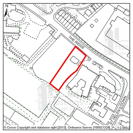
Figure 51: SH7 - 191 The Ridge
Site address: 191 The Ridge
Allocated use: Residential
Area: 0.15ha
Possible net capacity: 8
6.151 Site SH7 – 191 The Ridge is between two other allocated sites for residential redevelopment. The site contains a large residence set back from The Ridge with mature shrubs and trees at the boundaries. It is considered to be an acceptable location for further residential redevelopment in this area.
6.152 The site is within an Archaeological Notification Area so any proposals put to the Council will be referred to East Sussex County Council and, in consultation with the County Archaeologist, further investigation works and/or conservation may be required. Development proposals will need to show consideration of the transport impact along The Ridge. Further advice on transport matters is available from East Sussex County Council.
(2)
Policy
SH7 - 191 The Ridge
191 The Ridge is allocated for residential development (possible net capacity 8 dwellings).
The Council expects development proposals for this site to:
- Include affordable housing on site at 20% of the overall housing provision
- Include an Ecological Constraints and Opportunities Plan and incorporate conservation and mitigation measures as recommended by the Plan as appropriate.
- Provide an arboriculture plan that demonstrates how existing trees on site will be integrated into the development, or how compensation will be made for their loss;
- Include a Historic Environment Record (HER) desk-based assessment of potential interest within an Archaeological Notification Area and agree to a ‘watching brief’ during any development works (as advised by East Sussex County Council);
- Be supported by a Transport Report. The Report will need to take account of the site’s proximity to The Ridge. Proposals should indicate how the conclusions and recommendations of the Report have been incorporated. Potentially development may be required to contribute to improvements on The Ridge.
All policies of the Local Plan will be applied, as appropriate, to any scheme presented to the Council.
Focus Area 5: Silverhill & Alexandra Park
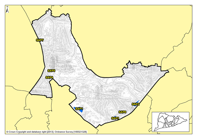
Figure 52: Focus Area 5 - Silverhill & Alexandra Park
Introduction to the Silverhill & Alexandra Park Planning Focus Area
6.153 From the edges of the town centre to the Silverhill shopping centre, this Focus Area follows the course of Alexandra Park, from its formal greens and gardens at the southern end to the wild and wooded reaches of Shornden and Old Roar Gill, which is a waterfall that tumbles into a narrow gorge filled with ferns and mosses.
6.154 Housing to the southern end of the area and around Silverhill centre is largely Victorian. Elsewhere, the housing is mostly inter-war, with some very elegant Art Deco houses along the edge of Alexandra Park. The area has shops and other facilities, and most of these are in the Silverhill shopping area. There are fewer of these to the south, where local people are more likely to go to Hastings Town centre for shopping, doctors and other facilities.
(1) 6.155 Employment in this Focus Area is generally centred on the Silverhill shopping centre, with a few small industrial premises, as well as retail. There is also a crop of civic buildings along Bohemia Road, including the law courts, Hastings’ principal police station, a fire station, ambulance station, some industrial units, and Horntye Sports Centre which includes Hastings cricket ground. This part of the area also includes some interesting archaeology, including an ice house and the ‘roman baths’.
6.156 The area is characterised by urban green space: to the west, Summerfields Woods, a local nature reserve; in the south Linton Gardens; and to the east the border runs along the eastern edge of the award-winning Alexandra Park, the Borough’s principal urban park. Alexandra Park includes the usual seaside attractions at the southern end, where there is a busy café, flower gardens, children’s playground, tennis courts, bowls and lakes. Further up, it becomes more natural, with woodlands and fishing lakes. The area includes Summerfields Woods, a local nature reserve in a steep-sided wooded valley, where you can find the remains of an old walled garden, now being restored. There are allotments in this area too, and other small green spaces.
6.157 In spite of all the open space, there are still over 10,000 people living in this Focus Area, with some parts, around Silverhill especially, relatively densely populated (40 people per hectare according to the 2001 Census). The age range of the population is evenly spread, displaying a mix of families with children, working age people and retirees.
6.158 The tenures in this focus area are two-thirds owner-occupation according to 2001 Census data and, in contrast to many of the other Focus Areas, there is a relatively high proportion (21%) of private rented accommodation in the Silverhill & Alexandra Park Focus Area. This last statistic could be reflective of a local population that is potentially less likely to stay in the same home as long as home owners.
Our Vision for Silverhill & Alexandra Park
(1) 6.159 This is an area dominated by protected open space: Alexandra Park, nature reserves, allotments and public playing fields. The significant public open spaces will be protected and enhanced. In particular, we would like to see better connections between Alexandra Park, Linton Gardens, Summerfields Woods, the town centre and seafront, with walking routes, cycling routes, and public transport key to this. We will encourage their use and perhaps increase community management.
6.160 Policy FA2 of the Planning Strategy plans for 300 - 360 new homes here over the next 15 years. A particular opportunity site could be at the Horntye sports centre. Given the relatively high densities of population in this Focus Area, and also the presence of Alexandra Park and other open space, potential development schemes will need to pay particular attention to innovative design solutions that address density and complement the open spaces. Opportunities to protect and enhance the connections for people and wildlife between the green spaces in this Focus Area should be fully investigated in connection with any development scheme that comes forward.
6.161 Silverhill is the commercial hub of the area, and we would expect this to remain so, and indeed to develop and improve as a retail centre. Here, there could be an opportunity for innovative design, so ideas for modern, commercial or retail development would be welcome. Away from the retail centre, Silverhill has other employment sites, and we would encourage their retention. There could be the potential to integrate appropriate employment opportunities into the more residential areas, including, for example, small workshops or live/work units.
Residential, mixed use and other allocations for Silverhill & Alexandra Park
| Site reference | Address | Reason for allocation (including potential number of homes) | Area (ha) | Does the site have a brief in Appendix A? |
|---|---|---|---|---|
| SAP1 | Horntye Park | Residential (115) | 1.01 |
|
| SAP2 | Hollingsworth Garage, Braybrooke Road | Residential (56) | 0.40 |
|
| SAP3 | 12-19 Braybrooke Terrace | Residential (25) | 0.23 |
|
| SAP4 | 347-349 London Road | Residential (18) | 0.15 |
|
| SAP5 | Silver Springs Medical Practice, Beaufort Road | Residential (9) | 0.12 |
|
| SAP7 | Bilmore Corner, Battle Road | Residential (8) | 0.06 |
|
| SAP8 | 4 Wykeham Road | Residential (6) | 0.03 |
|
Table 7: Residential, mixed use and other allocations for Silverhill & Alexandra Park
Site reference: SAP1 - Horntye Park
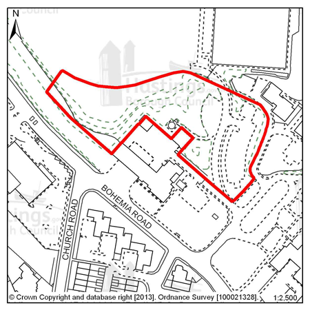
Figure 53: SAP1 - Horntye Park
Site address: Horntye Park
Allocated use: Residential
Area: 1.01ha
Possible net capacity: 115
(1) 6.162 Site SAP1 – Horntye Park is at the entrance to the sports complex. It is elevated from Bohemia Road and has a mature tree boundary. The access to the sports facilities will need to be maintained. Any loss of sports facilities will need to be compensated for. Given the size and location of the site the Council will expect any scheme to support a varied housing mix and may be required to include specific housing for wheelchair users, and affordable housing will also be required as part of the mix.
6.163 There is a Grade II listed ice house within this site which will need to be maintained by the site owner and/or developer. It is also required that occasional public access to the structure is provided for over the long term.
6.164 The capacity potential of this site indicates that a Transport Assessment and Travel Plan will be required, further advice is available from East Sussex County Council. The size of the site is over 1 hectare, as advised by the Environment Agency, a Flood Risk Assessment is required.
(2)
Policy
SAP1 - Horntye Park
Horntye Park is allocated for residential development (possible net capacity 115 dwellings).
The Council expects development proposals for this site to:
- Include affordable housing on site at 25% of the overall housing provision;
- Include at least 2% of the total number of new homes as fully adapted dwellings for wheelchair users;
- Sustain and enhance the significance and setting of the Grade II listed ice house including its insulating earth mound, and include the provision for appropriate public access;
- Include an Ecological Constraints and Opportunities Plan, including specific reference to the presence of the nearby Local Nature Reserve, and incorporate conservation and mitigation measures as recommended by the Plan as appropriate;
- Provide a financial contribution to the management of the Local Nature Reserve and opportunities for natural play within;
- Include a Flood Risk Assessment and flood resilient design as appropriate to the outcome of that report;
- Investigate the impact to, and potential loss of, sporting facilities at Horntye and as appropriate include mitigation and compensation as outlined by these investigations;
- Be supported by a Transport Assessment and Travel Plan. Proposals should indicate how the conclusions and recommendations of the Assessment have been incorporated.
All policies of the Local Plan will be applied, as appropriate, to any scheme presented to the Council.
Site reference: SAP2 - Hollingsworth Garage, Braybrooke Road
Figure 54: SAP2 - Hollingsworth Garage, Braybrooke Road
Site address: Hollingsworth Garage,
Braybrooke Road
Allocated use: Residential
Area: 0.40ha
Possible net capacity: 56
6.165 Site SAP2 – Hollingsworth Garage, Braybrooke Road is a relatively narrow site that was formerly home to a motor vehicle garage, between Braybrooke Road and the railway lines approaching Hastings station. The site is a prominent one, overlooking the town centre with views to the Castle. Submitted schemes will therefore need to show how they have had regard to the impact on both the local street scene and when seen from further afield. This site lies immediately to the south of the Blacklands Conservation Area. Any development on this site will need to sustain and enhance the setting of that Conservation Area.
6.166 The shape and topography of the site mean that access options are limited, and that the on-site parking that will need to be provided may require innovative solutions. The previous use of the site means that land contamination might be an issue and should be investigated. The tree belt between the site and the railway line, mostly off-site, should be retained and any adverse impact upon it avoided.
6.167 Given the size and location of the site the Council will expect any scheme to support a varied housing mix and may be required to include specific housing for wheelchair users, and affordable housing will also be required as part of the mix. The capacity potential of this site indicates that a Transport Statement and Travel Plan Statement will be required, further advice is available from East Sussex County Council.
(2)
Policy
SAP2 - Hollingsworth Garage, Braybrooke Road
Hollingsworth Garage, Braybrooke Road is allocated for residential development (possible net capacity 56 dwellings).
The Council expects development proposals for this site to:
- (1) Include affordable housing on site at 25% of the overall housing provision;
- Include at least 2% of the total number of new homes as fully adapted dwellings for wheelchair users;
- Sustain and enhance the significance and setting of the Blacklands Conservation Area and protect important views of Hastings Castle;
- Include an Ecological Constraints and Opportunities Plan, including specific reference to the presence of the adjacent mature tree belt, and incorporate conservation and mitigation measures as recommended by the Plan as appropriate;
- Provide an arboriculture plan that demonstrates how existing trees on and adjacent to the site will be integrated into the development, or how compensation will be made for their loss;
- Contribute to the improvement of existing play facilities in the surrounding area;
- Be supported by a Transport Statement and Travel Plan Statement. Proposals should indicate how the recommendations and conclusions of the Statement have been incorporated;
- Investigate the impact of land contamination and incorporate mitigation measures as appropriate.
Additional guidance is also given in a design brief for this site in Appendix A.
All policies of the Local Plan will be applied, as appropriate, to any scheme presented to the Council.
Site reference: SAP3 - 12-19 Braybrooke Terrace
Figure 55: SAP3 - 12-19 Braybrooke Terrace
Site address: 12-19 Braybrooke Terrace
Allocated use: Residential
Area: 0.23ha
Possible net capacity: 25
6.168 Site SAP3 – 12-19 Braybrooke Terrace is a relatively narrow site that is bounded by high retaining walls and significant level changes adjacent to it. Access options for the site are limited, and on site parking that will need to be provided may require innovative solutions. The high retaining walls and limited rear aspect mean that the amenity of future occupants must be considered in any potential scheme; it should be demonstrated that sufficient daylight can enter all the dwellings that are proposed on site.
6.169 The trees in the north of the site and adjacent to it – in Linton Gardens (a locally important historic park) – should also be retained, for their heritage and ecological value. Beneath the site there is a storm water retention tunnel and Southern Water will be invited to comment on any submitted proposals. It is recommended that advice is sought from Southern Water at an early stage by any potential applicant. This site will be expected to support a varied housing mix, including affordable housing. The capacity potential of this site indicates that a Transport Report will be required, further advice is available from East Sussex County Council.
6.170 The design brief for this site (see Appendix A) highlights the access issues and where there are some trees that should be retained.
Policy
SAP3 - 12-19 Braybrooke Terrace
12-19 Braybrooke Terrace is allocated for residential development (possible net capacity 25 dwellings).
The Council expects development proposals for this site to:
- Include affordable housing on site at 25% of the overall housing provision ;
- Sustain and enhance the significance and setting of Linton Gardens (a locally important heritage asset);
- Include an Ecological Constraints and Opportunities Plan and incorporate conservation and mitigation measures as recommended by the Plan as appropriate;
- Provide an arboriculture plan that demonstrates how existing trees on site will be integrated into the development, or how compensation will be made for their loss;
- Provide green space within the site boundary;
- Contribute to the improvement of existing play facilities in the surrounding area;
- Discussed proposals in advance with Southern Water because of the presence of the underground storm water tunnel;
- Provide a connection to the sewerage system at the nearest point of adequate capacity, as advised by Southern Water;
- Be supported by a Transport Report. Proposals should indicate how the conclusions and recommendations of the Report have been incorporated.
Additional guidance is also given in a design brief for this site in Appendix A.
All policies of the Local Plan will be applied, as appropriate, to any scheme presented to the Council.
Site reference: SAP4 - 347-349 London Road
Figure 56: SAP4 - 347-349 London Road
Site address: 347-349 London Road
Allocated use: Residential
Area: 0.15ha
Possible net capacity: 18
6.171 Site SAP4 – 347-349 London Road is a cleared brownfield site where there was previously a large building used as a dance school. The site offers the opportunity for residential development, an important consideration of which will be the access and egress onto London Road. This site will be expected to support a varied housing mix, including affordable housing. The capacity potential of this site indicates that a Transport Report will be required, further advice is available from East Sussex County Council.
Policy
SAP4 - 347-349 London Road
347-349 London Road is allocated for residential development (possible net capacity 18 dwellings).
The Council expects development proposals for this site to:
- Include affordable housing on site at 25% of the overall housing provision
- Be supported by a Transport Report. Proposals should indicate how the conclusions and recommendations of the Report have been incorporated.
All policies of the Local Plan will be applied, as appropriate, to any scheme presented to the Council.
Site reference: SAP5 - Silver Springs Medical Practice, Beaufort Road
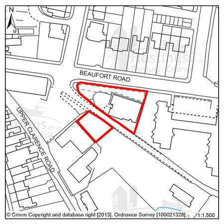
Figure 57: SAP5 - Silver Springs Medical Practice, Beaufort Road
Site address: Silver Springs Medical
Practice, Beaufort Road
Allocated use: Residential
Area: 0.12ha
Possible net capacity: 9
6.172 Site SAP5 – Silver Springs Medical Practice, Beaufort Road is an active medical practice that is looking to relocate. The site offers the opportunity for its redevelopment to housing. There is a proposed cycle route that runs between the two parcels of land that make up this allocation and this route should be preserved, and contributions to its creation and management may be sought. The capacity potential of this site indicates that a Transport Report will be required, further advice is available from East Sussex County Council.
Policy
SAP5 - Silver Springs Medical Practice, Beaufort Road
Silver Springs Medical Practice, Beaufort Road is allocated for residential development (possible net capacity 9 dwellings).
The Council expects development proposals for this site to:
- Include affordable housing on site at 20% of the overall housing provision;
- Safeguard land to enable the implementation of the strategic network of cycle routes and contribute to its creation and management as appropriate;
- Be supported by a Transport Report. Proposals should indicate how the conclusions and recommendations of the Report have been incorporated.
All policies of the Local Plan will be applied, as appropriate, to any scheme presented to the Council.
Site reference: SAP7 - Bilmore Corner, Battle Road
Figure 58: SAP7 - Bilmore Corner, Battle Road
Site address: Bilmore Corner, Battle
Road
Allocated use: Residential
Area: 0.06ha
Possible net capacity: 8
6.173 Site SAP7 – Bilmore Corner, Battle Road is vacant and represents a good opportunity for residential development. The site is in a residential area close to local shops and services. The capacity potential of this site indicates that a Transport Report will be required, further advice is available from East Sussex County Council.
(1)
Policy
SAP7 - Bilmore Corner, Battle Road
Bilmore Corner, Battle Road is allocated for residential development (possible net capacity 8 dwellings).
The Council expects development proposals for this site to:
- Include affordable housing on site at 20% of the overall housing provision
- Be supported by a Transport Report. Proposals should indicate how the conclusions and recommendations of the Report have been incorporated.
All policies of the Local Plan will be applied, as appropriate, to any scheme presented to the Council.
Site reference: SAP8 - 4 Wykeham Road
Figure 59: SAP8 - 4 Wykeham Road
Site address: 4 Wykeham Road
Allocated use: Residential
Area: 0.03ha
Possible net capacity: 6
6.174 Site SAP8 – 4 Wykeham Road is a relatively small and sloping site. It is in a residential area near to Hastings Railway Station and other town centre shops and services. The capacity potential of this site indicates that a Transport Report will be required, further advice is available from East Sussex County Council.
(1)
Policy
SAP8 - 4 Wykeham Road
4 Wykeham Road is allocated for residential development (possible net capacity 6 dwellings).
The Council expects development proposals for this site to:
- Include affordable housing on site at 20% of the overall housing provision
- Be supported by a Transport Report. Proposals should indicate how the conclusions and recommendations of the Report have been incorporated.
All policies of the Local Plan will be applied, as appropriate, to any scheme presented to the Council.
Focus Area 6: Maze Hill & Burtons’ St Leonards
Figure 60: Focus Area 6 - Maze Hill & Burtons’ St Leonards
Introduction to Maze Hill & Burtons’ St Leonards Planning Focus Area
6.175 This area covers the ‘historic’ part of St Leonards, from the 1930s Art Deco Marine Court on the seafront, to Markwick Terrace and its surrounding streets, extending in the east from London Road to the edge of West Marina gardens. Much of Maze Hill & Burtons’ St Leonards has conservation area status. It is characterised by a mixture of Regency and Victorian villas and imposing terraces characterised by elegant gleaming white housing, interspersed with formal gardens at Markwick Terrace and St Leonards Gardens (one of two parks in the Borough that are on the English Heritage Register of Parks and Gardens of Special Historic Interest).
(1) 6.176 Burtons’ St Leonards itself is of great architectural and townscape interest as it forms the core of the original Regency new town designed and built by James Burton and his son Decimus between1828 – 1835. Their vision included a mix of architectural styles, from Scottish baronial ‘castles’ to mock-Tudor manor houses. To the south east of the area is Mercatoria, the old ‘tradesmen’s’ area built to serve Burtons’ St Leonards. Here, houses are smaller, and have suffered from considerable neglect, although they are now improving through the general regeneration of this part of St Leonards. There are specialist shops, including antiques dealers and art galleries. The seafront here has undergone some regeneration and is slowly returning to its former 19th Century splendour. Beyond Burtons’ St Leonards and Mercatoria, to the west in particular, there is some more recent housing in small pockets, ranging from 1950s detached houses to late 20th Century terraces.
(1) 6.177 This is one of the smaller planning Focus Areas. According to 2001 Census data, just over 4,500 residents live here, and half of them are over the age of 45 (older than the average Hastings resident). There are fewer families with children in the area, with the lowest percentage of under 15 year-olds in Hastings, and a significant number of households with older people. Some of the larger houses in the area have been converted into residential homes for older people. There are a limited number of shops and other community facilities here.
6.178 2001 Census data puts population density in Maze Hill & Burtons’ St Leonards at just under 39 people per hectare. The area has parts that are more densely populated than others and this reflects the relatively small but closely built buildings towards the seafront and the larger properties further inland, as well as the green spaces in between. There is a mix of housing tenures in Maze Hill & Burtons’ St Leonards but it is dominated by two kinds, with over 70% of the homes in the Focus Area being owned by their inhabitants and, compared to other Focus Areas, a relatively high percentage being privately rented (19%).
Our vision for Maze Hill & Burtons’ St Leonards
6.179 This Focus Area is characterised by statement, often pastiche, and interesting architecture, much of which is in conservation areas. As such, there are certain expectations about the design and materials to be used in any potential development schemes. Early assessment and appreciation of the situation of any proposed development will be particularly important in Maze Hill & Burtons’ St Leonards, and the design and layout should be sympathetic to its surroundings. Where it is appropriate, schemes that involve a mix of housing that includes family homes will be encouraged. We are planning for 240-300 new homes to be built in the area over the next 15 years. The most significant redevelopment site in the area is at the old Hastings College site on Archery Road.
6.180 Mercatoria, which was built as the ‘commercial’ part of Burtons’ St Leonards, offers great potential to increase the number of specialist shops and artist studios for which this area of the Borough is known. Live/work units and innovative smaller projects will be encouraged, for example for artists, food retail and catering.
6.181 Elsewhere, there may be further opportunities for developing small studio-style live/work units, particularly as a way of renovating properties. The nature of this area has the potential to lend itself to tourist accommodation, particularly in the form of small, boutique hotels and guest houses.
6.182 Along the seafront, we will continue to encourage improvements to properties. We will work with partners to promote and improve buildings to create better quality accommodation, but would want to retain the overall period look of the seafront, with the exterior of buildings restored to their original specification wherever possible.
Residential, mixed use and other allocations for Maze Hill & Burtons’ St Leonards
| Site reference | Address |
Reason for allocation (including potential number of homes) |
Area (ha) | Does the site have a brief in Appendix A? |
|---|---|---|---|---|
| MBL1 | Former Hastings College, Archery Road | Residential (100) | 2.22 | ? |
| MBL2 | 37 Charles Road West, (Former Filsham Nurseries) | Residential (9) | 0.26 | ? |
| MBL3 | Gambier House, West Hill Road | Residential (15) | 0.23 | ? |
| MBL4 | West Hill Road Reservoir | Residential (14) | 0.19 | ? |
| MBL5 | 27 Dane Road | Residential (11) | 0.14 | ? |
| MBL8 | Caple Ne Ferne, 2 Albany Road | Residential (8) | 0.18 | ? |
Table 8: Residential, mixed use and other allocations for Maze Hill and Burtons’ St Leonards
Site reference: MBL1 - Former Hastings College, Archery Road
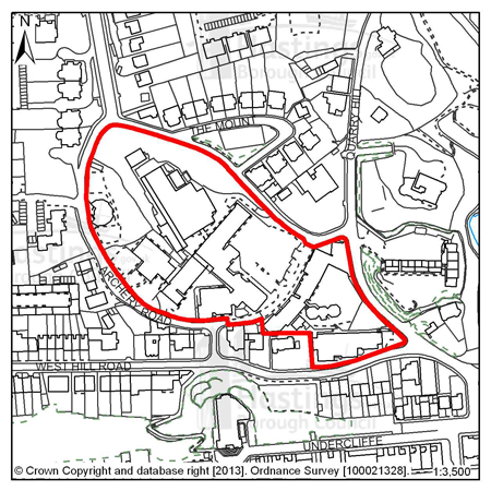
Figure 61: MBL1 - Former Hastings College, Archery Road
Site address: Former Hastings College, Archery Road
Allocated use: Residential
Area: 2.22ha
Possible net capacity: 100
6.183 Site MLB1 – Former Hastings College, Archery Road Redevelopment will remove the existing redundant buildings and will provide the opportunity to convert the listed buildings and introduce a new use for the remainder of the site. In terms of the volume and form of future development, key factors that need to be taken into account in any redevelopment proposals is the relationship of any new development to the terrace of listed buildings within the site, the site’s location within St Leonard’s West Conservation Area, the potential impact on a number of listed buildings adjacent to the site boundaries and three other adjacent conservation areas. There are also a number of mature shrubs and trees on site that will need to be surveyed for their ecological and arboriculture value, and appropriate conservation and mitigation measures found in relation to them.
6.184 Given the size and location of the site the Council will expect any scheme to support a varied housing mix and may be required to include specific housing for wheelchair users, and affordable housing will also be required as part of the mix. The capacity potential of this site indicates that a Transport Assessment and Travel Plan will be required, further advice is available from East Sussex County Council. The size of the site is over 1 hectare, as advised by the Environment Agency, a Flood Risk Assessment is required.
(1)
Policy
MBL1 - Former Hastings College, Archery Road
Former Hastings College, Archery Road is allocated for residential development (possible net capacity 100 dwellings).
The Council expects development proposals for this site to:
-
Include affordable housing on site at 25% of the overall housing provision;
-
Include at least 2% of the total number of new homes as fully adapted dwellings for wheelchair users;
-
Sustain and enhance the significance and setting of the listed terrace in the south of the site and the surrounding Conservation Areas;
-
Include an Ecological Constraints and Opportunities Plan and incorporate conservation and mitigation measures as recommended by the Plan as appropriate;
-
Provide an arboriculture plan that demonstrates how existing trees on site will be integrated into the development, or how compensation will be made for their loss;
-
Include a Flood Risk Assessment and flood resilient design as appropriate to the outcome of that report;
-
Contribute to the improvement of existing play facilities in the surrounding area;
-
Include walking and cycling links to improve local connectivity and to preserve the Public Right of Way across the site;
-
To provide a connection to the sewerage and water supply systems at the nearest point of adequate capacity, as advised by Southern Water;
-
Be supported by a Transport Assessment and Travel Plan. Proposals should indicate how the conclusions and recommendations of the Assessment have been incorporated.
All policies of the Local Plan will be applied, as appropriate, to any scheme presented to the Council.
Site reference: MBL2 - 37 Charles Road West (Former Filsham Nurseries)
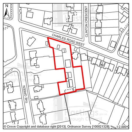
Figure 62: MBL2 - 37 Charles Road West (Former Filsham Nurseries)
Site address: 37 Charles Road West (Former Filsham Nurseries)
Allocated use: Residential
Area: 0.26ha
Possible net capacity: 9
6.185 Site MBL2 – 37 Charles Road West (Former Filsham Nurseries) is a vacant brownfield site where the former business has ceased to operate. The site is in an existing residential area and offers an appropriate redevelopment opportunity. The capacity potential of this site indicates that a Transport Report will be required, further advice is available from East Sussex County Council.
Policy
MBL2 - 37 Charles Road West (Former Filsham Nurseries)
37 Charles Road West (Former Filsham Nurseries) is allocated for residential development (possible net capacity 9 dwellings).
The Council expects development proposals for this site to:
-
Include affordable housing on site at 20% of the overall housing provision;
-
Be supported by a Transport Report. Proposals should indicate how the conclusions and recommendations of the Report have been incorporated.
All policies of the Local Plan will be applied, as appropriate, to any scheme presented to the Council.
Site reference: MBL3 - Gambier House, West Hill Road
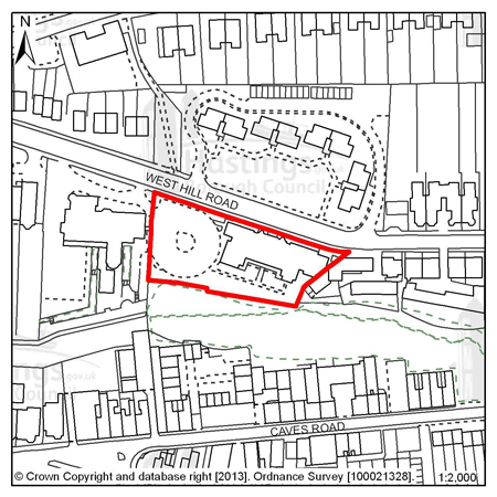
Figure 63: MBL3 - Gambier House, West Hill Road
Site address: Gambier House, West Hill Road
Allocated use: Residential
Area: 0.23ha
Possible net capacity: 15
6.186 Site MBL3 – Gambier House, West Hill Road is a browfield site; the existing buildings were vacated by the NHS in July 2011. The site is in a prominent cliff top location that offers a good residential development opportunity.
(1) 6.187 The site is located within the Grosvenor Gardens Conservation Area and the retention of the ‘Gambier House’ building is preferred, and any scheme involving its demolition will need to robustly demonstrate the reasoning behind such a proposal. The site has an existing access point that should be taken advantage of and this is displayed on the design brief for the site, in Appendix A. The capacity potential of this site indicates that a Transport Report will be required, further advice is available from East Sussex County Council. Affordable housing will be expected in any residential development scheme, and it will be important that any adverse impacts on the adjacent Local Wildlife Site are avoided.
Policy
MBL3 - Gambier House, West Hill Road
Gambier House, West Hill Road is allocated for residential development (possible net capacity 15 dwellings.
The Council expects development proposals for this site to:
-
Include affordable housing on site at 25% of the overall housing provision ;
-
Sustain and enhance the significance and setting of the Grosvenor Gardens Conservation Area;
-
Include an Ecological Constraints and Opportunities Plan, including specific reference to the presence of the adjacent Local Wildlife Site, and incorporate conservation and mitigation measures as recommended by the Plan as appropriate;
-
Be supported by a Transport Report. Proposals should indicate how the conclusions and recommendations of the Report have been incorporated.
Additional guidance is also given in a design brief for this site in Appendix A.
All policies of the Local Plan will be applied, as appropriate, to any scheme presented to the Council.
Site reference: MBL4 - West Hill Road Reservoir
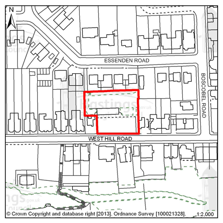
Figure 64: MBL4 - West Hill Road Reservoir
Site address: West Hill Road Reservoir
Allocated use: Residential
Area: 0.19ha
Possible net capacity: 14
6.188 Site MBL4 – West Hill Road Reservoir is a former Water Board site that is roughly rectangular is shape. It is a brownfield site in an existing residential area, which is within the Grosvenor Gardens Conservation Area. The site offers a good redevelopment opportunity. The capacity potential of this site indicates that a Transport Report will be required, further advice is available from East Sussex County Council.
Policy
MBL4 - West Hill Road Reservoir
West Hill Road Reservoir is allocated for residential development (possible net capacity 14 dwellings).
The Council expects development proposals for this site to:
-
Include affordable housing on site at 20% of the overall housing provision;
-
Be supported by a Transport Report. Proposals should indicate how the conclusions and recommendations of the Report have been incorporated;
-
Sustain and enhance the significance and setting of the Grosvenor Gardens Conservation Area.
All policies of the Local Plan will be applied, as appropriate, to any scheme presented to the Council.
Site reference: MBL5 - 27 Dane Road
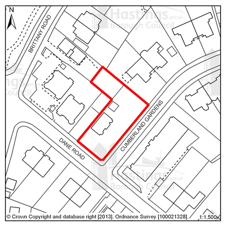
Figure 65: MBL5 - 27 Dane Road
Site address: 27 Dane Road Allocated use: Residential Area: 0.14ha
Possible net capacity: 11
6.189 Site MBL5 – 27 Dane Road is a corner plot in and existing residential area. The site represents a Greenfield development opportunity and it should be should be noted that this site is within the Markwick Terrace Conservation Area. The capacity potential of this site indicates that a Transport Report will be required, further advice is available from East Sussex County Council.
Policy
MBL5 - 27 Dane Road
27 Dane Road is allocated for residential development (possible net capacity 11 dwellings).
The Council expects development proposals for this site to:
-
Include affordable housing on site at 20% of the overall housing provision
-
Be supported by a Transport Report. Proposals should indicate how the conclusions and recommendations of the Report have been incorporated;
-
Sustain and enhance the significance and setting of the Markwick Terrace Conservation Area
All policies of the Local Plan will be applied, as appropriate, to any scheme presented to the Council.
Site reference: MBL8 - Caple Ne Ferne, 2 Albany Road
Figure 66: MBL8 - Caple Ne Ferne, 2 Albany Road
Site address: Caple Ne Ferne, 2 Albany Road
Allocated use: Residential
Area: 0.18ha
Possible net capacity: 8
6.190 Site MBL8 – Caple Ne Ferne, 2 Albany Road is the northern extension of a Grade II listed building. The building was last in use as a drug/alcohol rehabilitation treatment centre. The site is in a residential area, in the Markwick Terrace Conservation Area, and represents an opportunity for residential redevelopment. The capacity potential of this site indicates that a Transport Report will be required, further advice is available from East Sussex County Council.
(1)
Policy
MBL8 - Caple Ne Ferne, 2 Albany Road
Caple Ne Ferne, 2 Albany Road is allocated for residential development (possible net capacity 8 dwellings).
The Council expects development proposals for this site to:
-
Include Affordable Housing on site at 20% of the overall housing provision ;
-
Be supported by a Transport Report. Proposals should indicate how the conclusions and recommendations of the Report have been incorporated;
-
Sustain and enhance its significance and setting as part of a Grade II listed building;
-
Sustain and enhance the significance and setting of the Markwick Terrace Conservation Area.
All policies of the Local Plan will be applied, as appropriate, to any scheme presented to the Council.
Focus Area 7: Central St Leonards & Bohemia
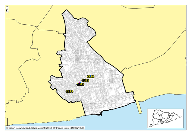
Figure 67: Focus Area 7 - Central St Leonards & Bohemia
Introduction to the Central St Leonards & Bohemia Planning Focus Area
(1) 6.191 Extending from White Rock gardens in the east to Grand Parade in the west, and inland to the Bohemia Road shopping area, this is the most densely populated part of the Borough, with approximately 85 people per hectare and almost 9,500 residents. It is also the second most economically deprived (ONS) with almost 20% of the working age population claiming Job Seekers Allowance (Department of Work and Pensions – Nomis statistics).
(1) 6.192 In spite of the high population density, there are some significant open spaces, notably Warrior Square with its formal seaside planting, White Rock Gardens, and Gensing Gardens. St Leonards Warrior Square railway station is here too, at the heart of the shopping centre. Housing here is mostly terraced and Victorian, with many Houses in Multiple Occupation (HMO). The employers here are predominantly shops and public sector employers, such as the Revenues & Customs and Social Services offices at Ocean House.
6.193 After the waning of its Victorian heydays, Central St Leonards & Bohemia have begun to change. Around St Leonards Town Centre and the seafront, significant regeneration has taken place. Many derelict properties along the seafront have been refurbished, and a new health centre has been built on the site of the long-derelict Marlborough Hotel. More recently, new ‘boutique’ hotels have opened, nationally promoted as fashionable places to stay. Around St Leonards centre, some of the narrow streets adjacent to Mercatoria, in the Gensing Farm area, have seen an up-lift, with owners refurbishing previously run-down properties. And the shopping centre itself is changing fast, with an influx of new cafés, restaurants and shops signalling significant new investment in many of the shopping streets.
6.194 This is also an ethnically diverse part of Town, with many different nationalities represented. This has led to the opening of many niche shops, cafés and restaurants to meet the needs of these particular parts of the community, and these attract visitors to the area. This trend is contributing to the positive regeneration of the Focus Area.
Our Vision for Central St Leonards & Bohemia
(1) 6.195 The regeneration of this area has begun, but it is only a start. We need to encourage new businesses to the area, retail in particular. However, tourist accommodation in the shape of more ‘boutique’ hotels particularly along the seafront is important. Other businesses in the creative sector would especially fit in well with the mix and atmosphere of this area. So we will do all we can to encourage small businesses, and work with them to promote and establish themselves. We expect St Leonards centre to become a focus for independent and niche shops, cafés and restaurants, something that serves the local community as well as being a tourist attraction. This is something that we will investigate through the potential for a cultural quarter in this area promoting joint working between the Local Authority, business owners and the local community.
6.196 Policy FA2 of the Planning Strategy indicates a range of 240-300 new homes to be planned for here over the next 15 years. This is a town centre where flats and small terraced houses can provide low-priced starter homes for younger residents. We will expect these to be of innovative design, creating good quality homes, with a mix of ownership, rented and affordable housing.
6.197 The seafront will also continue to improve, becoming more of a tourist destination and connecting with St. Leonards centre. As well as using enforcement powers to get property owners to improve their buildings, we will investigate and encourage, where appropriate, quality conversions of properties to visitor accommodation, particularly along the seafront. To retain the character of the seafront we will be encouraging restoration rather than replacement of properties, at least externally. The Council-owned seafront structures, especially ‘Bottle Alley’ will also need major refurbishment. We anticipate that changes here will mean the creation of catering and retail spaces on the seafront, and will do all we can to encourage local businesses to take up these opportunities.
(1) 6.198 To the north of the area around the Bohemia shopping centre, the decline of the retail centre needs to be managed. We will investigate the possibilities here, including retail, catering, workshops, live/work units, or even conversions back into residential properties.
Residential, mixed use and other allocations for Central St Leonards & Bohemia
| Site reference | Address | Reason for allocation (including potential number of homes) | Area (ha) | Does the site have a brief in Appendix A? |
|---|---|---|---|---|
| CLB1 | 1-3 Chapel Park Road | Residential (27) | 0.13 | ? |
| CLB2 | Taxi office/B.R. Social Club, St Johns Road | Mixed use (30) | 0.12 | ? |
| CLB3 | Sorting Office site, Kings Road | Mixed use (9) | 0.05 | ? |
| CLB4 | 4-5 Stockleigh Road | Residential (12) | 0.03 | ? |
Table 9: Residential, mixed use and other allocations for Central St Leonards & Bohemia
Site reference: CLB1 - 1-3 Chapel Park Road
Figure 68: CLB1 – 1-3 Chapel Park Road
Site address: 1-3 Chapel Park Road
Allocated use: Residential
Area: 0.13ha
Possible net capacity: 27
6.199 Site CLB1 – 1-3 Chapel Park Road is a prominent corner site that sits above Warrior Square Station alongside the entrance to the eastbound tunnel, currently occupied by a pair of semi-detached villas.
6.200 CLB1 is sited immediately adjacent to the Kings Road Conservation Area. Proposals for this site will therefore need to take account of the likely impact on the Kings Road Conservation Area. This site will be expected to support a varied housing mix, including affordable housing. The capacity potential of this site indicates that a Transport Report will be required, further advice is available from East Sussex County Council.
(5)
Policy
CLB1: 1-3 Chapel Park Road
1-3 Chapel Park Road is allocated for residential development (possible net capacity 27 dwellings).
The Council expects development proposals for this site to:
-
(1) Include affordable housing on site at 25% of the overall housing provision;
-
Be supported by a Transport Report. Proposals should indicate how the conclusions and recommendations of the Report have been incorporated;
-
(3) Sustain and enhance the significance and setting of the adjacent Kings Road Conservation Area;
-
Contribute to the improvement of existing play facilities in the surrounding area.
All policies of the Local Plan will be applied, as appropriate, to any scheme presented to the Council.
Site reference: CLB2 - Taxi Office/B.R. Social Club, St Johns Road
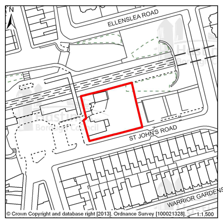
Figure 69: CLB2 – Taxi Office/B.R. Social Club, St Johns Road
Site address: Taxi Office/B.R. Social Club, St Johns Road
Allocated use: Mixed Use
Area: 0.12ha
Possible net capacity: 30
(5) 6.201 Site CLB2 – Taxi Office/B.R. Social Club, St Johns Road represents a redevelopment opportunity to create a landmark building that would act as a catalyst for the broader regeneration of Central St Leonards.
(8) 6.202 The Council wish to encourage a vibrant active street level frontage to the Station Forecourt and St John’s Road occupied by commercial uses, with residential above. Although the possible net capacity is set at 30 dwellings, consideration would be given to a larger number, subject to Policy CLB2 and other policies within the Local Plan. The site will be expected to support a varied housing mix, including affordable housing.
(3) 6.203 Located within the Kings Road Conservation Area, new development would need to be high quality, complement the existing urban form, and enhance the architectural value of the existing buildings. Specific importance is attached to the relationship with the existing buildings along St John’s Road, particularly in regard to privacy and overlooking. The relationship with the attractive station buildings to the west is also important.
(2) 6.204 The site is located in an area of surface water flood risk and given the previous uses of this site, there is also potential for land contamination.
(1) 6.205 No vehicular access will be permitted from the Station Forecourt. All vehicular access will need to occur from St John’s Road. The capacity potential of this site indicates that a Transport Report will be required, further advice is available from East Sussex County Council.
(6)
Policy
CLB2: Taxi Office/B.R. Social Club, St Johns Road
The Taxi Office/B.R. Social Club, St Johns Road is allocated for mixed use development (possible net capacity 30 dwellings).
The Council expects development proposals for this site to:
-
(1) Include affordable housing on site at 25% of the overall housing provision;
-
(4) Sustain and enhance the significance and setting of the Kings Road Conservation Area;
-
(2) Include commercial uses on the ground floor, with residential above;
-
Contribute to the improvement of existing play facilities in the surrounding area;
-
(1) Incorporate vehicular access from St Johns Road and pedestrian access from the station forecourt;
-
Investigate the impact of land contamination and incorporate mitigation measures as appropriate;
-
Incorporate measures to address surface water flood risk such as Sustainable Drainage Systems;
-
Be supported by a Transport Report. Proposals should indicate how the conclusions and recommendations of the Report have been incorporated.
Additional guidance is also given in a design brief for this site in Appendix A.
All policies of the Local Plan will be applied, as appropriate, to any scheme presented to the Council.
Site reference: CLB3 - Sorting Office site, Kings Road
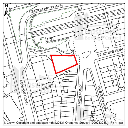
Figure 70: CLB3 – Sorting Office site, Kings Road
Site address: Sorting Office site, Kings Road
Allocated use: Mixed use (commercial with residential above)
Area: 0.05ha
Possible net capacity: 9
6.206 Site CLB3 – Sorting Office site, Kings Road is a vacant and cleared site, occupying an area in the south-west corner of Warrior Square Station. It abuts the Kings Road shopping area on its southern side. Both the shopping street and station are within the Kings Road Conservation Area and the application site occupies an important position between the two. The capacity potential of this site indicates that a Transport Report will be required, further advice is available from East Sussex County Council.
Policy
CLB3: Sorting Office site, Kings Road
The Sorting Office site, Kings Road is allocated for mixed use development (possible net capacity 9 dwellings). The Council expects development proposals for this site to:
-
Include affordable housing on site at 20% of overall housing provision;
-
Be supported by a Transport Report. Proposals should indicate how the conclusions and recommendations of the Report have been incorporated;
-
Sustain and enhance the significance and setting of the Kings Road Conservation Area;
-
Include commercial uses on the ground floor, with residential above.
All policies of the Local Plan will be applied, as appropriate, to any scheme presented to the Council.
Site reference: CLB4 - 4-5 Stockleigh Road
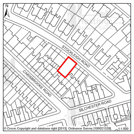
Figure 71: CLB4 – 4-5 Stockleigh Road
Site address: 4-5 Stockleigh Road
Allocated use: Residential
Area: 0.03ha
Possible net capacity: 12
6.207 Site CLB4 – 4-5 Stockleigh Road is a vacant site, located between bay fronted Victorian terraces and Stockleigh Court. The site is within the St Leonards North Conservation Area. The capacity potential of this site indicates that a Transport Report will be required, further advice is available from East Sussex County Council.
Policy
CLB4: 4-5 Stockleigh Road
4-5 Stockleigh Road is allocated for residential development (possible net capacity 12 dwellings)
The Council expects development proposals for this site to:
-
Include affordable housing on site at 20% of the overall housing provision;
-
Be supported by a Transport Report. Proposals should indicate how the conclusions and recommendations of the Report have been incorporated;
-
Sustain and enhance the significance and setting of the St Leonards North Conservation Area.
All policies of the Local Plan will be applied, as appropriate, to any scheme presented to the Council.
Focus Area 8: Hastings Town Centre
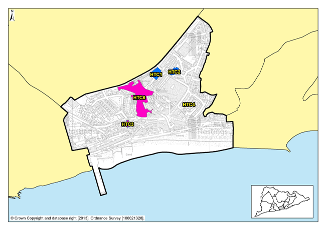
Figure 72: Focus Area 8 - Hastings Town Centre
Introduction to the Hastings Town Centre Planning Focus Area
6.208 This Focus Area is the commercial and retail heart of the Borough, extending from the Old Town in the east to White Rock in the west, and inland as far as Summerfields Wood and the railway line between London and Ashford. Most of the town’s comparison retail trade takes place here, and the tightly constrained physical boundaries of Hastings have generally prevented the development of out-of-town shopping.
6.209 Hastings Town Centre has a good representation of national high street retail, catering and other business chains and there are also many independent shops, cafés and bars. The latter are predominantly in the traditional shopping areas along Robertson Street, Queens Road, and in St Andrew’s Square and Queens Arcade. Morrisons supermarket also occupies a significant part of this Focus Area. Many of the shops in Hastings town centre are Victorian, although newer buildings have replaced them in some areas, notably in the modern Priory Meadow shopping centre, where the Victorian cricket ground on which it stands is remembered with the bronze sculpture of a batsman.
6.210 The architecture of Hastings Town Centre takes on many forms and patterns. There are Victorian terraces; mid 20th Century retail blocks and very recent retail, office and educational developments. There are also many separate and distinct buildings including Pelham Crescent, St Mary in the Castle and the Brassey Institute. There are also lesser know gems too, such as the Victorian warehouses along Duke Street. This is another Focus Area where eclectic architecture has, and continues to, help define its character. There are tourist attractions, such as the White Rock Theatre, Hastings Museum and Art Gallery, and the seafront itself. And there are residential areas too, predominantly around St Andrew’s Square, Wellington Square and Holmsdale Gardens.
6.211 Significant regeneration has taken place, notably the Lacuna Place development and 1 Priory Square, Sussex Coast College, the improved railway station, a new health centre and the Hastings campus of the University of Brighton. Major improvements to the seafront through ‘grotbuster’ enforcement action, with many of the formerly derelict seafront buildings now refurbished and back in use, have also occurred. But significant regeneration challenges remain: White Rock Baths, the Observer Building, and Hastings Pier all remain out of use, although the pier does now have a hopeful future, thanks to the Hastings Pier and White Rock Trust.
6.212 Around 3,500 people live in Hastings Town Centre (according to 2001 Census data), and these are predominantly young adults. Almost 50% of the houses in this Focus Area are owned by their occupants. However, a relatively high proportion (38%) of homes are privately rented and a number of them are Homes in Multiple Occupancy, which suggests a relatively transient population. Around a fifth of the working age population of this Focus Area is in receipt of Job Seeker’s Allowance (Department of Work and Pensions – Nomis statistics). The residents are able to access a high level of services and facilities: doctors, dentists, a library and more, all within the Town Centre, but the good public transport connections, especially at Hastings’ railway station and the adjoining bus interchange, provide the opportunity to travel further afield.
Our Vision for Hastings Town Centre
6.213 Conservation areas cover much of the Hastings Town Centre Focus Area, and because of this, there are extra guidelines over what form development can take. It will be important for many features of the Focus Area to be preserved and enhanced; nevertheless there are still considerable redevelopment opportunities where innovation and excitement can prevail. Consideration will be given to the appropriate inclusion of taller buildings.
6.214 Outlined in the Planning Strategy (Policy FA2) is the potential for another 20,500 square metres of comparison retail floor space, and this should be accommodated within the Town Centre boundary, so redevelopment opportunities could be suggested.
6.215 In particular, we want to see the development of Priory Quarter continued, including the rest of Havelock Road north of Lacuna Place, Queensbury House, and Priory Street, to create employment, retail and leisure uses. The Observer Building needs to be brought back into use too.
6.216 There are opportunities in Hastings town centre for residential development – town centres are a good location for homes, particularly good-quality flats that can also serve as starter homes for young people. Introducing new housing into town centres can improve the balance and ‘feel’ of a place, especially at night. Policy FA2 of the Planning Strategy sets the range of new homes provided in Hastings Town Centre over the next fifteen years at 200 - 240.
6.217 Improvement and refurbishment of some of the residential areas and tourist accommodation has begun in the Focus Area and we will encourage the continuation and expansion of this, where appropriate, across Hasting Town Centre.
6.218 On the seafront, we expect to see Hastings Pier and White Rock Baths brought back into use. We will do all we can to help Hastings Pier and White Rock Trust build a modern, regenerated pier, and will help the Foreshore Trust get White Rock Baths back in use, with possible temporary uses for the upper parts initially. Further east, we anticipate that the seafront will continue to be used for leisure and catering purposes, although would hope to see these further developed and improved.
Residential, mixed use and other allocations for Hastings Town Centre
| Site reference | Address |
Reason for allocation (including potential number of homes) |
Area (ha) | Does the site have a brief in Appendix A? |
|---|---|---|---|---|
| HTC1 | Hastings Station Yard (part) | Mixed residential (27) | 0.44 |
|
| HTC2 | Cornwallis Street Car Park | Residential (10) | 0.22 |
|
| HTC3 | The Observer Building (part) | Mixed use (39) | 0.07 |
|
| HTC4 | 40 & 41 Wellington Square | Residential (12) | 0.02 |
|
Table 10: Residential, mixed use and other allocations for Hastings Town Centre
Employment Allocations
| Site reference | Address | Potential gross floorspace (m2) | Area (ha) | Does the site have a brief in Appendix A? |
|---|---|---|---|---|
| HTC6 | Priory Quarter, Havelock Road | 21,700 | 2.58 |
|
Table 11: Employment allocations for Hastings Town Centre
Site reference: HTC1 - Hastings Station Yard (part)
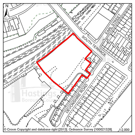
Figure 73: HTC1 – Hastings Station Yard (part)
Site address: Hastings Station Yard (part)
Allocated use: Mixed Residential
Area: 0.44ha
Possible net capacity: 27
6.219 Site HTC1 – Hastings Station Yard (part) the majority of which has already been redeveloped for educational (Sussex Coast College) and health care purposes, and includes a small retail element. The remaining part of the site continues to be suitable for residential use but may also be suited to a mixed use scheme including alternative residential uses such as student accommodation. The site will be expected to support a varied housing mix and to include affordable housing.
6.220 New development on HTC1 will have to take account of the amenity of adjoining residents, particularly those in Devonshire Road. HTC1 is located in an area deficient in open space, and the proposed strategic network of cycle routes runs along the northern boundary. The capacity potential of this site indicates that a Transport Report will be required, further advice is available from East Sussex County Council. Water infrastructure also crosses the site, which will require easement as part of new development.
(1)
Policy
HTC1: Hastings Station Yard (part)
Hastings Station Yard (part) is allocated for mixed residential development; (Use Class C3) and also the opportunity for student accommodation (possible net capacity 27 (C3) units).
The Council expects development proposals for this site to:
-
Include affordable housing on site at 25% of the overall housing provision;
-
Include an Ecological Constraints and Opportunities Plan and incorporate conservation and mitigation measures as recommended by the Plan as appropriate.;
-
Contribute to the improvement of existing play facilities in the surrounding area;
-
Safeguard land to enable the implementation of the strategic network of cycle routes and contribute to its creation and management as appropriate;
-
Be supported by a Transport Report. Proposals should indicate how the conclusions and recommendations of the Report have been incorporated.
All policies of the Local Plan will be applied, as appropriate, to any scheme presented to the Council.
Site reference: HTC2 - Cornwallis Street Car Park
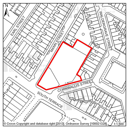
Figure 74: HTC2 – Cornwallis Street Car Park
Site address: Cornwallis Street car park
Allocated use: Residential
Area: 0.22ha
Possible net capacity: 10
6.221 Site HTC2 - Cornwallis Street car park is located in Hastings Town Centre near to other residential properties and incorporates an existing access route from Cornwallis Street. Flood Zone 2 extends towards the north corner of the site so a Flood Risk Assessment will be required and mitigation as advised by the report should be incorporated into any potential scheme.
6.222 The loss of parking provision through the redevelopment of the car park will also need to be addressed in future proposals. The capacity potential of this site indicates that a Transport Report will be required, further advice is available from East Sussex County Council.
(4)
Policy
HTC2: Cornwallis Street Car Park
Cornwallis Street car park is allocated for residential development (possible net capacity 10 dwellings).
The Council expects development proposals for this site to:
-
Include affordable housing on site at 20% of the overall housing provision;
-
Include a Flood Risk Assessment and flood resilient design as appropriate to the outcome of that report;
-
Make best use of the existing access from Cornwallis Street;
-
Be supported by a Transport Report. Proposals should indicate how the conclusions and recommendations of the Report have been incorporated, including the consideration of measures to secure continued public access parking either on site or elsewhere.
All policies of the Local Plan will be applied, as appropriate, to any scheme presented to the Council.
Site reference: HTC3 - The Observer Building
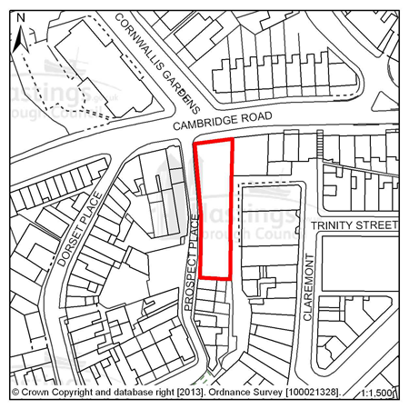
Figure 75: HTC3 – The Observer Building
Site address: The Observer Building
Allocated use: Mixed use (residential and commercial)
Area: 0.07ha
Possible net capacity: 39
6.223 HTC3 – The Observer Building is allocated for mixed use development. The Council would encourage the mix of uses to include tourist accommodation, retail, educational or leisure facilities as well as residential units. The site will be expected to support a varied housing mix and to include affordable housing.
6.224 This is a vacant multi-storey building occupying a prominent position on a route into Hastings Town Centre. It is located in the Town Centre Conservation Area and adjacent to 2 listed buildings.
6.225 There is currently no parking provision or access (other than pedestrian) to serve the site. The capacity potential of this site indicates that a Transport Statement will be required, further advice is available from East Sussex County Council.
6.226 Previous uses of the building may mean that there are contamination issues that need to be investigated, and the site falls within an Archaeological Notification Area. Southern Water has also indicated that a connection will be required to the nearest sewer and there is potential to release capacity through surface water removal.
(1)
Policy
HTC3: The Observer Building
The Observer building is allocated for mixed use development including residential, commercial and/or educational uses (possible net capacity 39 dwellings).
The Council expects development proposals for this site to:
-
(1) Include affordable housing on site at 25% of the overall housing provision;
-
Sustain and enhance the significance and setting of the Town Centre Conservation Area and adjacent Listed Buildings;
-
Include a Historic Environment Record (HER) informed desk-based assessment of potential interest within an Archaeological Notification Area and agree to a ‘watching brief’ during any development works (as advised by East Sussex County Council);
-
Contribute to the improvement of existing play facilities in the surrounding area;
-
Be supported by a Transport Statement. Proposals should indicate how the conclusions and recommendations of the Statement have been incorporated;
-
Investigate the impact of land contamination and incorporate mitigation measures as appropriate;
-
Provide a connection to the sewerage system at the nearest point of adequate capacity and/or make improvements to the infrastructure if necessary, as advised by Southern Water.
All policies of the Local Plan will be applied, as appropriate, to any scheme presented to the Council.
Site reference: HTC4 - 40 & 41 Wellington Square
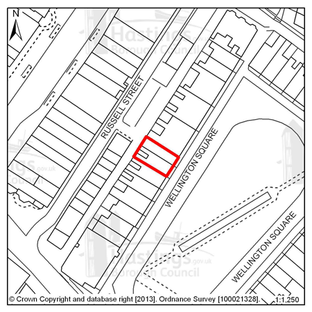
Figure 76: HTC4 – 40 & 41 Wellington Square
Site address: 40 & 41 Wellington Square
Allocated use: Residential
Area: 0.02ha
Possible net capacity: 12
6.227 Site HTC4 – 40 & 41 Wellington Square is within the Old Town Conservation Area. All the buildings in Wellington Square are listed in recognition of their importance as a group. The site also falls within an Archaeological Notification Area. The capacity potential of this site indicates that a Transport Report will be required, further advice is available from East Sussex County Council.
Policy
HTC4: 40 & 41 Wellington Square
40 & 41 Wellington Square is allocated for residential development (possible net capacity 12 dwellings).
The Council expect development proposals for this site to:
-
Include an affordable housing contribution equivalent to 20% of the overall housing provision;
-
Be supported by a Transport Report. Proposals should indicate how the conclusions and recommendations of the Report have been incorporated;
-
Sustain and enhance the significance and setting of the listed buildings and the Old Town Conservation Area;
-
Include a Historic Environment Record (HER) informed desk-based assessment of potential interest within an Archaeological Notification Area and agree to a ‘watching brief’ during any development works (as advised by East Sussex County Council).
All policies of the Local Plan will be applied, as appropriate, to any scheme presented to the Council.
Site reference: HTC6 - Priory Quarter, Havelock Road
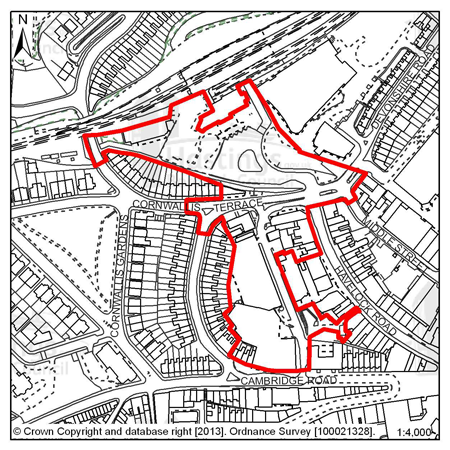
Figure 77: HTC6 – Priory Quarter, Havelock Road
Site address: Priory Quarter, Havelock Road
Allocated uses: Employment - use class B1 (and mixed use: Retail – use classes A1/A3); Hotel - use class C1; Education – use class D1; Leisure - use class D2; Car parking – sui-generis use class)
Area: 2.58ha
Potential floorspace (gross): 21,700m2 (of use class B1)
6.228 Site HTC6 – Priory Quarter, Havelock Road has outline planning permission (subject to a legal agreement) for a large scale mixed use development comprising offices, education, retail and leisure. It encompasses a significant part of the Academic Cultural Quarter, and is allocated primarily for business development, but also allows for other complementary uses - retail, education, car parking, hotel and/or leisure proposals, should they come forward.
6.229 Site HTC6 is located within the Town Centre Conservation Area and is in an Archaeological Notification Area. Deep surface water flood risk affects parts of the site, and the proposed strategic network of cycle routes runs though the northern end.
6.230 A design brief has been prepared to help guide development in this location (see Appendix A). The following phasing of development is considered appropriate:
- Queensbury House and adjoining sites – redevelopment for office scheme (existing planning permission);
- Station area – Office and/or hotel development, including public car parking to replace that lost through redevelopment;
- Priory Street Car Park – Office development including complementary uses as appropriate;
- ESK Warehouse – Office development and/or retail/education.
6.231 Future redevelopment should consider re-arrangement of the station forecourt area to improve pedestrian circulation and connectivity, as well as the removal of through traffic from Priory Street to provide a safe and improved pedestrian route through the core of Priory Quarter. The proposed scale of development also provides the opportunity to support the introduction of district heating in the town centre. The capacity potential of this site indicates that a Transport Assesment and Travel Plan will be required, further advice is available from East Sussex County Council.
(1)
Policy
HTC6: Priory Quarter, Havelock Road
Priory Quarter , Havelock Road is allocated for employment development, incorporating other complementary uses including education, retail, leisure and hotel uses as appropriate (indicative gross floorspace 21,700m2 of use class B1).
The Council expect development proposals for this site to:
-
Protect and enhance the significance and setting of the Town Centre Conservation Area;
-
Include a Historic Environment Record (HER) informed desk-based assessment of potential interest within an Archaeological Notification Area and agree to a ‘watching brief’ during any development works (as advised by East Sussex County Council);
-
Include a Flood Risk Assessment and incorporate measures to reduce the risk of flooding such as Sustainable Drainage Systems;
-
Investigate the feasibility of introducing district heating systems;
-
Secure high quality public realm and improve pedestrian circulation and connectivity;
-
Safeguard land to enable the implementation of the strategic network of cycle routes and contribute to its creation and management as appropriate;
-
Incorporate measures to secure continued public access parking;
-
Be supported by a Transport Assessment and a Travel Plan. Proposals should indicate how the conclusions and recommendations of Assessment have been incorporated.
Additional guidance for this site is set out in a design brief in Appendix A.
All policies of the Local Plan will be applied, as appropriate, to any scheme presented to the Council.
Focus Area 9: Old Town
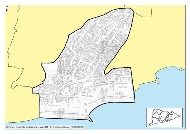
Figure 78: Focus Area 9 - Old Town
Introduction to the Old Town Planning Focus Area
6.232 Hastings Old Town is the oldest part of the Borough, extending between the East and West Hill from the iconic net shops on the beach, up to All Saints Church at the head of The Bourne. Some of the housing and other buildings here date back to the thirteenth century, woven through a maze of narrow streets and twittens that delight both visitors and residents.
6.233 The Old Town has had a mixed history of twentieth century planning. For example, the demolition of housing along The Bourne to create a route for the A259 effectively divided the area in two and was a low point, but there are large areas of sympathetic 1970s redevelopment. The Old Town remains a desirable place to live and house prices here are the highest in Hastings. It is also the densest housing in the town, with few open spaces, although it is very close to the Country Park and West Hill. All of the Old Town is in a conservation area, and many of the buildings are Grade II listed.
6.234 2001 Census data shows that the population in the Old Town is the oldest in the Borough, with around a third above retirement age. By contrast, only a tenth of the population is under 16, the lowest in the Borough. New community facilities at the Stade Hall help to provide a centre for local community activities, and the area is reasonably well served by other community services with the Stables Theatre, a doctor’s surgery, pharmacy, and local food shops.
6.235 There is various employment in this Focus Area; the Hastings fishery at the Stade, with its direct employment of fishermen, as well as many indirect jobs, in related onshore trades, and the tourism that the fishing industry brings with it. There is much employment in retail and catering too, with a thriving network of busy, independent shops and cafes and pubs along George Street, High Street and Rock-a-Nore. There is also a wealth of small studios and workshops, used largely by working artists and other craft-related trades. There is also some more seasonal employment concentrated on ‘traditional’ tourism, with souvenir shops, amusements and all that is on offer on the seafront.
6.236 New development has taken place in the Old Town in recent years, most notably the Jerwood Gallery, Stade Open Space, café and Stade Hall, with the style and design of this being modern and creative but sympathetic to its setting. There is a new hotel in Rock-a-Nore being built, replacing the old ice house that had been derelict for many years. This helps to give visitors to Hastings a wide range of things to see and do during their time here, from traditional seaside amusements, to eating and drinking, to art appreciation and everything in between.
Our Vision for the Old Town
6.237 Since the charm of the Old Town, and its value as a place to live and work, is dependent on its centuries-old character, any new development would have to be sympathetic to this. Almost all of the buildings in the area should be maintained and preserved in their current form, retaining its rich architectural heritage. But this does not mean that there should not be any new development. So we will allow new development in the Old Town, where this complements the existing townscape and does not damage existing historic buildings, both in terms of their physical structure and their visual setting. Any new development here would have to be carried out to the highest architectural quality. But that doesn’t mean it has to be a mock-historical pastiche; the Old Town must continue to grow and react to changing times.
6.238 This approach obviously raises potential conflicts, in particular between businesses wanting to develop opportunities, and the need to conserve architectural heritage. So while we will continue to pay close attention to the materials and construction techniques used in the conversion of existing buildings, we will work with those looking to develop schemes and help them to achieve their aims and aspirations whilst the character and important buildings of the Old Town are preserved for future generations.
6.239 Policy FA5 of the Planning Strategy sets out a range of 50-70 new homes to be built in the Old Town during the next fifteen years, but businesses and new jobs will be just as important. With the average age of the local population growing, and being significantly higher than the rest of the borough, it is important to make sure that young people can remain in the area. That will be difficult if there are no jobs apart from seasonal, tourism-related jobs, and no affordable housing. So we need to promote the creation of both affordable housing, and sustainable employment, particularly with small employers in the creative sector.
Focus Area 10: West Hill
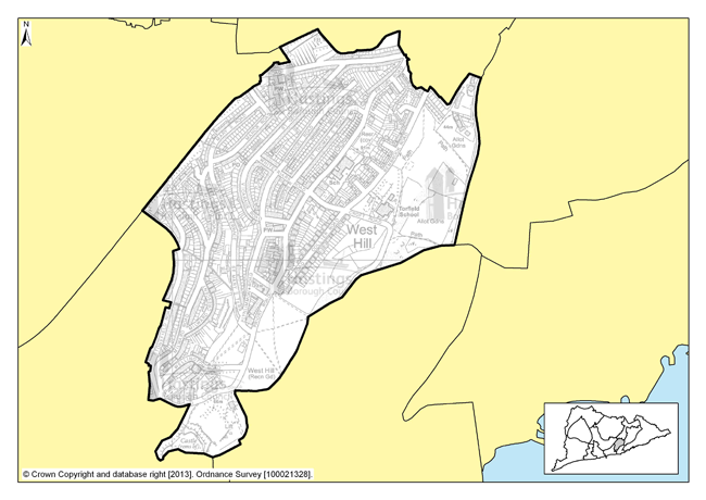
Figure 79: Focus Area 10 - West Hill
Introduction to the West Hill Planning Focus Area
6.240 The West Hill Focus Area is made up of mostly terraced Victorian housing, stretching from the West Hill open space, with its spectacular views across the town and sea, to Mount Pleasant in the west and Torfield allotments in the east, while extending to the north as far to the edge of Halton Estate.
6.241 At the southern end stands the Borough’s only Grade I listed building: Hastings Castle. The housing near the Castle are elegant, seaside villas. Some of the big, cliff top hotels and boarding houses have also been converted into flats or Houses in Multiple Occupation.
6.242 Moving inland, the houses are larger and more densely packed. Streets here are narrow and lined with parked cars, with few open spaces between, giving the feel of a crowded, highly populated area. Families with children predominate: the area has the lowest proportion of retired people in the Borough, but the second highest proportion of children under 16, according to 2001 Census data.
6.243 Some gentrification has taken place in the terraced cottages closest to the cliffs, with many of these having been refurbished and turned into holiday lets or weekend retreats. Most of the housing here is private, beyond a few small infill blocks of ex-council flats.
6.244 2001 Census data supports that this is a busy, densely populated part of town, with over 5,500 people living here, in one of the smallest Focus Areas. The density of population does mean that corner shops, small businesses and local pubs have survived relatively well. There are even some ‘traditional’ workshops and light engineering businesses, mixed in amongst the Victorian terraces. One fifth of the working age population, however, is in receipt of Job Seeker’s Allowance (Department of Work and Pensions – Nomis statistics). While the area is well served by open spaces and children’s play areas, these are all at the southern and eastern edges of the area.
Our Vision for West Hill
6.245 Hastings Castle, owned by the Council, needs considerable investment to bring it up to standard as a tourist destination, making the most of its status as one of the world’s most famous buildings. The vista of open space and elegant housing that surrounds the castle should be preserved. We would, however, encourage the continued development of holiday accommodation in this ‘cliff top zone’, helping the renovation and regeneration of housing back along the streets that lead away from the sea. With local shops serving a community of holidaymakers and residents enjoying sea views and sunshine amongst pretty, colourful streets and seaside gardens, this part of the Borough will continue to be a prime destination.
6.246 However, this whole Focus Area contains few opportunities for new development, and the densely packed terraces would make this difficult. Policy FA2 suggests a range of 60-80 new homes to be provided here over the next fifteen years, and the redevelopment and reuse of existing buildings will be an important part of this. Potential development schemes would have to pay particular attention to local population density, the setting of the Castle, and be sympathetic to the character of the Victorian terraces.
6.247 The small local shops and businesses in this area are one of its assets, so we would want to preserve and improve these. We would look favourably, too, on ideas for new small businesses, especially from the creative sector. Artists’ studios and workshops in particular would fit in with the feel and atmosphere of the southern part of the area.
Focus Area 11: Hillcrest & Ore Valley
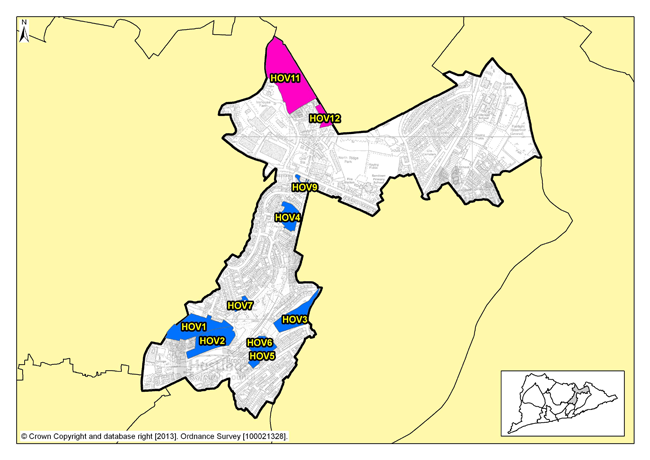
Figure 80: Focus Area 11 - Hillcrest & Ore Valley
Introduction to the Hillcrest & Ore Valley Planning Focus
6.248 This t-shaped Focus Area, which includes housing predominantly in mid-twentieth century estates, sweeps up from the West Hill to the Ridge and North’s Seat, and borders some of the best natural green spaces in town. The quality of the buildings often appears to be in contrast with the spectacular views towards the sea and also northwards to the High Weald AONB. Ore Valley & Hillcrest also includes the Ivyhouse Lane industrial estate, one of the Borough’s principle employment areas. This is on the northern edge of the area and is somewhat disconnected from the many areas of housing that predominate here.
6.249 Hillcrest & Ore Valley is dominated by social housing, in estates built between the 1950s and 70s: Halton, Farley Bank, Broomgrove, Red Lake and Downs Farm. While some of this housing is semi-detached housing with gardens (as in Red Lake), much of it is flats and maisonettes. Attempts have been made to introduce a more diverse mix of housing, with some blocks of flats being demolished. But land values are low and there has been little interest shown by developers, so the sites remain as development potential yet to be realised.
6.250 This area also includes the Ore Valley regeneration site area, formerly a ‘Millennium Communities’ project, comprising an old railway goods yard and power station. Here, some redevelopment has been completed, with housing built around a new road to the Ore railway station where new offices and shops will be provided.
6.251 The statistics for this Focus Area make for hard reading: over 60% of children live in households below the official UK poverty level (ONS), and there is the highest proportion of children for a Focus Area in the Borough. Roughly one fifth of the working age population is on Job Seeker’s Allowance (Department of Work and Pensions – Nomis statistics). Educational and training opportunities are improving significantly though, with the new Sussex Coast College opened in the Ore Valley regeneration area, and the new Hastings Academy at the Hillcrest School site. Other services include community centres and a ‘Sure Start’ children’s centre, but opportunities to increase what is available remain, especially in terms of local retail.
Our Vision for Hillcrest & Ore Valley
6.252 There are already significant redevelopment opportunities on vacant sites at Broomgrove and the Ore Valley. Over the next 15 years, Policy FA5 of the Planning Strategy indicates a range of 440-540 homes is to be planned for. We need a better mix of housing tenures, but any large-scale redevelopment would have to take account of the local economic circumstances, meaning that the current levels of social housing would need to be retained overall, albeit with a better, more integrated mix. While new housing on currently vacant sites could be offered for sale, this is an ideal area for low-cost ‘starter’ homes, giving local social housing tenants a route into property ownership.
6.253 One of the biggest challenges in this Focus Area is the lack of employment opportunities, and the alienation of its young people. To tackle this, we think it is important to bring employment opportunities back into the community, so young people can get jobs locally, go to work, and get paid. So, as well as protecting and improving existing employment land and industrial areas, particularly the Ivyhouse Lane employment area, we want to encourage the development of small businesses within the community – including live/work units, micro-engineering workshops, high-tech internet-based employers, along with more ‘traditional’ local businesses, such as car repairers and builders. Some of these could be retail units, providing not only employment, but also much-needed local services.
6.254 We must also protect green spaces in the area, which provide an important recreational opportunity especially for children. So where development does occur, the opportunities to help protect and enhance open spaces will be encouraged along with, where appropriate, the provision of children’s play equipment.
Residential, mixed use and other allocations for Hillcrest & Ore Valley
| Site reference | Address | Reason for allocation (including potential number of homes) | Area (ha) | Does the site have a brief in Appendix A? |
|---|---|---|---|---|
| HOV1 | Former Stills Factory, Ore Valley | Residential (75) | 2.71 |
|
| HOV2 | Ore Valley | Residential (50) | 2.35 |
|
| HOV3 | Former Mount Pleasant Hospital, Frederick Road | Residential (40) | 1.84 |
|
| HOV4 | The Cheviots/Cotswold Close | Residential (79) | 1.23 |
|
| HOV5 | 87-221 (odds) Farley Bank | Residential (29) | 0.73 |
|
| HOV6 | Ore Business Park, Farley Bank | Residential (19) | 0.70 |
|
| HOV7 | Upper Broomgrove Road | Residential (12) | 0.28 |
|
| HOV9 | 107 The Ridge (Simes & Sons) | Residential (8) | 0.22 |
|
Table 12: Residential, mixed use and other allocations for Hillcrest & Ore Valley
Employment allocations
| Site reference | Address | Potential gross floorspace (m2) | Area (ha) | Does the site have a brief in Appendix A? |
|---|---|---|---|---|
| HOV11 | Ivyhouse Lane, northern extension | 7,000 | 5.80 |
|
| HOV12 | Land east of Burgess Road, Ivyhouse | 1,400 | 0.51 |
|
Table 13: Employment allocations for Hillcrest & Ore Valley
Site reference: HOV1 - Former Stills Factory, Ore Valley
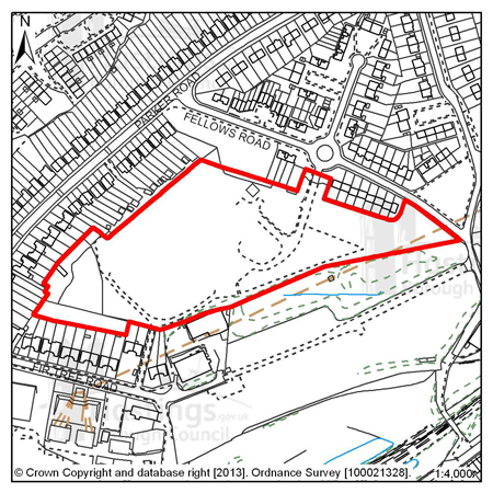
Figure 81: HOV1 – Former Stills Factory, Ore Valley
Site address: Former Stills Factory, Ore Valley
Allocated use: Residential
Area: 2.71ha
Possible net capacity: 75
6.255 Site HOV1 – Former Stills Factory forms part of a wider area known as Ore Valley, the regeneration of which has been a long term objective of the Council. Through the former Millennium Communities programme, Sussex Coast College and the first phase of housing has already been completed. Whilst the Millennium Communities programme has now ended, the remaining sites continue to be allocated for development.
6.256 The neighbouring site HOV2 gives the opportunity for more comprehensive planning of the area, particularly in respect of achieving pedestrian and cycle routes between the two sites. The site will be expected to support a varied housing mix, including affordable housing. Given the previous uses of this site there is the potential for contamination, which would need to be investigated. The capacity potential of this site indicates that a Transport Statement will be required, further advice is available from East Sussex County Council.
6.257 The site encompasses trees and shrubs on all boundaries, as well as two significant groups of trees within the site itself. A Local Wildlife Site is also located nearby.
6.258 Southern Water has indicated there is currently insufficient sewerage capacity to serve the site, which will need to be addressed in development proposals. The size of the site is over 1 hectare, as advised by the Environment Agency, a Flood Risk Assessment is required.
Policy
HOV1: Former Stills Factory, Ore Valley
The Former Stills Factory is allocated for residential development (possible net capacity 75 dwellings). The Council expects development proposals for this site to:
-
Include affordable housing onsite at 25% of the overall housing provision;
-
Include at least 2% of the total number of new homes as fully adapted dwellings for wheelchair users;
-
Include an Ecological Constraints and Opportunities Plan, including specific reference to the presence of the nearby Local Wildlife Site, and incorporate conservation and mitigation measures as recommended by the Plan as appropriate;
-
Maintain and enhance existing boundary landscaping on all sides;
-
Include open space within the site, some of which should include equipped children’s play provision (shared with HOV2);
-
Include walking and cycling links to improve local connectivity specifically between this site and HOV2 and to Fir Tree Road to the south;
-
Include a Flood Risk Assessment and flood resilient design as appropriate to the outcome of that report;
-
Be supported by a Transport Statement. Proposals should indicate how the conclusions and recommendations of the Statement have been incorporated;
-
Investigate the impact of land contamination and incorporate mitigation measures as appropriate;
-
Provide a connection to the sewerage system at the nearest point of adequate capacity and/or make improvements to the infrastructure if necessary, as advised by Southern Water.
Additional guidance (that includes opportunities to connect to adjoining sites) is also given in a design brief for this site in Appendix A.
All Local Plan policies will be considered during the decision making process as appropriate.
Site reference: HOV2 - Ore Valley
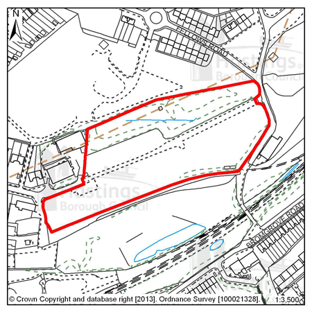
Figure 82: HOV2 – Ore Valley
Site address: Ore Valley
Allocated use: Residential
Area: 2.35ha
Possible net capacity: 50
(1) 6.259 Site HOV2 – Ore Valley forms part of a wider Ore Valley regeneration area, the redevelopment and regeneration of which has been a long term objective of the Council. Through the former Millennium Communities programme, Sussex Coast College and the first phase of housing has already been completed. Whilst the Millennium Communities programme has now ended, the remaining sites continue to be allocated for development.
6.260 The neighbouring site HOV1 gives the opportunity for more comprehensive planning of the area, particularly in respect of achieving pedestrian and cycle routes between the two sites. The site will be expected to support a varied housing mix, including affordable housing. Given the previous uses of this site there is potential for contamination, which would need to be investigated. The capacity potential of this site indicates that a Transport Statement and Travel Plan Statement will be required, further advice is available from East Sussex County Council.
6.261 The developable parts of this site are confined to the southern half and a smaller area to the north. The remainder of the site is woodland, which should be retained and arrangements made for its management. Access is available from an existing access point to Fellows Road at the eastern end of the site. If achievable, a vehicular, pedestrian and cycle link to the south should be provided to link with the phase 1 development and the open space area.
6.262 The site is located in an area of deep surface water flood risk, and Southern Water has indicated that there is currently insufficient sewerage capacity to serve the site. It is also located adjacent to a designated Local Wildlife Site, and will require its own ecological assessment in terms of future development.
6.263 The design brief that accompanies this site should be used as a reference to guide potential schemes (see Appendix A).
Policy
HOV2: Ore Valley
Ore Valley is allocated for residential development (possible net capacity 50 dwellings).
The Council expects development proposals for this site to:
-
Include affordable housing on site at 25% of the overall housing provision;
-
Include at least 2% of the total number of new homes as fully adapted dwellings for wheelchair users;
-
Include an Ecological Constraints and Opportunities Plan, including specific reference to the presence of the nearby Local Wildlife Site, and incorporate conservation and mitigation measures as recommended by the Plan as appropriate;
-
Maintain and enhance existing boundary landscaping on all sides;
-
Include a Flood Risk Assessment and incorporate measures to address surface water flood risk such as Sustainable Drainage Systems;
-
Include open space within the site, some of which should include equipped children’s play provision (shared with HOV1);
-
Include walking and cycling links to improve local connectivity specifically between this site and HOV1;
-
Be supported by a Transport Statement and Travel Plan Statement. Proposals should indicate how the conclusions and recommendations of the Statement have been incorporated;
-
Investigate the impact of land contamination and incorporate mitigation measures as appropriate;
-
Provide a connection to the sewerage system at the nearest point of adequate capacity and/or make improvements to the infrastructure if necessary, as advised by Southern Water.
Additional guidance (that includes opportunities to connect to adjoining sites) is also given in a design brief for this site in Appendix A.
All Local Plan policies will be considered during the decision making process as appropriate.
Site reference: HOV3 - Former Mount Pleasant Hospital, Frederick Road
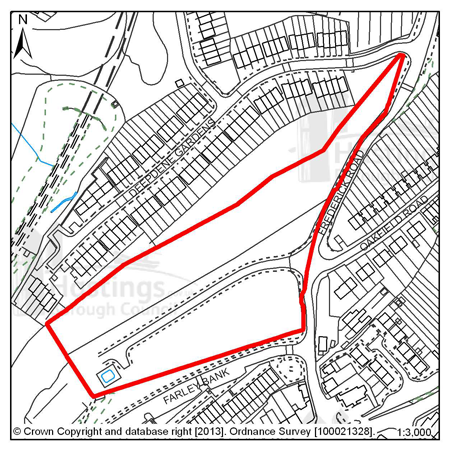
Figure 83: HOV3 – Former Mount Pleasant Hospital, Frederick Road
Site address: Former Mount Pleasant Hospital, Frederick Road
Allocated use: Residential
Area: 1.84ha
Possible net capacity: 40
6.264 Site HOV3 – Former Mount Pleasant Hospital, Frederick Road forms part of a wider Ore Valley regeneration area, the redevelopment and regeneration of which has been a long term objective of the Council. Through the former Millennium Communities programme, Sussex Coast College and the first phase of housing has already been completed. Whilst the Millennium Communities programme has now ended, the remaining sites continue to be allocated for development.
6.265 A spine road to service the site runs north-east to south-west along the centre of the site. The position of the spine road together with the narrowness of the site suggests that housing development is likely to take the form of frontage development on either side of the road, although there may be alternative approaches that might be acceptable, including more depth of development in the south-eastern part of the site. The site will be expected to support a varied housing mix, including affordable housing. A large drainage storage tank to the west of the turning head will need to be protected as part of future redevelopment. The capacity potential of this site indicates that a Transport Statement will be required, further advice is available from East Sussex County Council.
6.266 The proposed network of strategic cycle routes runs through the top part of the site, as well as an Ecology Zone. The size of the site is over 1 hectare, as advised by the Environment Agency, a Flood Risk Assessment is required.
6.267 Southern Water has indicated that there is currently insufficient sewerage capacity to serve the site.
Policy
HOV3: Former Mount Pleasant Hospital, Frederick Road
The Former Mount Pleasant Hospital, Frederick Road is allocated for residential development (possible net capacity 40 dwellings).
The Council expects development proposals for this site to:
-
Include affordable housing on site at 25% of the overall housing provision;
-
Include an Ecological Constraints and Opportunities Plan and incorporate conservation and mitigation measures as recommended by the Plan as appropriate. This should include an updated Management Plan for the Ecology Zone, including measures for the management and ongoing maintenance of that area;
-
Include a Flood Risk Assessment and flood resilient design as appropriate to the outcome of that report;
-
Contribute to the improvement of existing play facilities in the surrounding area;
-
Safeguard land to enable the implementation of the strategic network of cycle routes and contribute to its creation and management as appropriate;
-
Be supported by a Transport Statement. Proposals should indicate how the conclusions and recommendations of the Statement have been incorporated;
-
Safeguard the existing drainage storage tank within the site;
-
Provide a connection to the sewerage system at the nearest point of adequate capacity and/or make improvements to the infrastructure if necessary, as advised by Southern Water.
Additional guidance (that includes opportunities to connect to adjoining sites) is also given in a design brief for this site in Appendix A.
All Local Plan policies will be considered during the decision making process as appropriate.
Site reference: HOV4 - The Cheviots/Cotswold Close
Figure 84: HOV4 – The Cheviots/Cotswold Close
Site address: The Cheviots/Cotswold Close
Allocated use: Residential
Area: 1.23ha
Possible net capacity: 79
6.268 HOV4 – The Cheviots/Cotswold Close is a vacant site. In view of the site’s potential capacity and location, it will be expected to support a varied housing mix including affordable housing. Southern Water has indicated that water supply and wastewater infrastructure crosses the site and there is insufficient sewerage capacity. This underground infrastructure will require easement to allow for future maintenance and upgrading or could potentially be diverted at the developer’s expense. The size of the site is over 1 hectare, as advised by the Environment Agency, a Flood Risk Assessment is required. Development proposals will need to show consideration of the transport impact along The Ridge. Further advice on transport matters is available from East Sussex County Council.
(2)
Policy
HOV4: The Cheviots/Cotswold Close
The Cheviots/Cotswold Close site is allocated for residential development (possible net capacity 79 dwellings). The Council expects development proposals for this site to:
-
Include affordable housing on site at 25% of the overall housing provision;
-
Include at least 2% of the total number of new homes as fully adapted dwellings for wheelchair users;
-
Include an Ecological Constraints and Opportunities Plan and incorporate conservation and mitigation measures as recommended by the Plan as appropriate;
-
Include a Flood Risk Assessment and flood resilient design as appropriate to the outcome of that report;
-
Contribute to the improvement of existing play facilities in the surrounding area;
-
Provide a connection to the sewerage system at the nearest point of adequate capacity and/or make improvements to the infrastructure if necessary, as advised by Southern Water;
-
Be supported by a Transport Statement and Travel Plan Statement. The Transport Statement will need to take account of the site’s proximity to The Ridge. Proposals should indicate how the conclusions and recommendations of the Statement have been incorporated. Potentially development may be required to contribute to improvements on The Ridge.
All Local Plan policies will be considered during the decision making process as appropriate.
Site reference: HOV5 - 87-221 (odds) Farley Bank
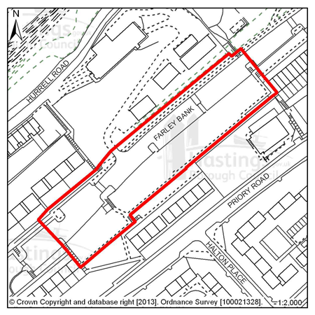
Figure 85: HOV5 – 87-221 (odds) Farley Bank
Site address: 87-221 (odds) Farley Bank
Allocated use: Residential
Area: 0.73ha
Possible net capacity: 29
6.269 Site HOV5 – 87-221 (odds) Farley Bank is a cleared site, previously occupied by housing. The site will be expected to support a varied housing mix including affordable housing. Southern Water has indicated that water supply and wastewater infrastructure crosses site and there is insufficient sewerage capacity. The capacity potential of this site indicates that a Transport Report will be required, further advice is available from East Sussex County Council.
(1)
Policy
HOV5: 87-221 (odds) Farley Bank
87-221 (odds) Farley Bank is allocated for residential development (possible net capacity 29 dwellings). The Council expects development proposals for this site to:
-
Include affordable housing on-site at 25% of overall housing provision;
-
Contribute to the improvement of existing play facilities in the surrounding area;
-
Provide a connection to the sewerage system at the nearest point of adequate capacity and/or make improvements to the infrastructure if necessary, as advised by Southern Water;
-
Be supported by a Transport Report. Proposals should indicate how the conclusions and recommendations of the Report have been incorporated.
All Local Plan policies will be considered during the decision making process as appropriate.
Site reference: HOV6 - Ore Business Park, Farley Bank
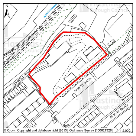
Figure 86: HOV6 – Ore Business Park, Farley Bank
Site address: Ore Business Park, Farley Bank
Allocated use: Residential
Area: 0.70ha
Possible net capacity: 19
6.270 Site HOV6 – Ore Business Park, Farley Bank is currently occupied by single storey industrial units although some have been demolished. It is allocated for residential development and will be expected to support a varied housing mix, including affordable housing.
6.271 The site lies adjacent to a designated Local Wildlife Site and Southern Water has indicated that there is currently insufficient sewerage capacity. The proposed strategic network of cycle routes runs through the site. The capacity potential of this site indicates that a Transport Report will be required, further advice is available from East Sussex County Council.
Policy
HOV6: Ore Business Park, Farley Bank
Ore Business Park, Farley Bank is allocated for residential development (possible net capacity 19 dwellings).
The Council expects development proposals for this site to:
-
Include affordable housing on site at 25% of the overall housing provision;
-
Contribute to the improvement of existing play facilities in the surrounding area;
-
Safeguard land to enable the implementation of the strategic network of cycle routes and contribute to its creation and management as appropriate;
-
Include the upgrade of the existing service road, if it is not replaced as part of any scheme;
-
Provide a connection to the sewerage system at the nearest point of adequate capacity and/or make improvements to the infrastructure if necessary, as advised by Southern Water;
-
Investigate the impact of land contamination and incorporate mitigation measures as appropriate;
-
Be supported by a Transport Report. Proposals should indicate how the conclusions and recommendations of the Report have been incorporated.
All Local Plan policies will be considered during the decision making process as appropriate.
Site reference: HOV7 - Upper Broomgrove Road
Figure 87: HOV7 – Upper Broomgrove Road
Site address: Upper Broomgrove Road
Allocated use: Residential
Area: 0.28ha
Possible net capacity: 12
6.272 Site HOV7 – Upper Broomgrove Road is a vacant site formally occupied by flats. A designated Local Wildlife Site runs directly adjacent to the proposed development site, with various trees and other wildlife being present on the site itself. A high voltage power line also dissects the site in a north-south direction. The capacity potential of this site indicates that a Transport Report will be required, further advice is available from East Sussex County Council.
(1)
Policy
HOV7: Upper Broomgrove Road
Upper Broomgrove Road is allocated for residential development (possible net capacity 12 dwellings).
The Council expects development proposals for this site to:
-
Include affordable housing on site at 20% of the overall housing provision;
-
Include an Ecological Constraints and Opportunities Plan, including specific reference to the presence of the adjacent Local Wildlife Site, and incorporate conservation and mitigation measures as recommended by the Plan as appropriate;
-
Be supported by a Transport Report. Proposals should indicate how the conclusions and recommendations of the Report have been incorporated.
All Local Plan policies will be considered during the decision making process as appropriate.
Site reference: HOV9 - 107 The Ridge (Simes & Sons)
Figure 88: HOV9 – 107 The Ridge (Simes & Sons)
Site address: 107 The Ridge (Simes & Sons)
Allocated use: Residential
Area: 0.22ha
Possible net capacity: 8
6.273 Site HOV9 – 107 The Ridge (Simes & Sons) is a former industrial site, located on The Ridge, one of the main roads that runs across the north of the town. The site is of an irregular shape and access needs to be carefully considered. The eastern section of the site lies over the Ore railway tunnel. Development proposals will need to show consideration of the transport impact along The Ridge. Further advice on transport matters is available from East Sussex County Council.
6.274 The site falls within an Archaeological Notification Area and there is also potential for contamination on the site, which would need to be investigated in future proposals.
Policy
HOV9: 107 The Ridge (Simes & Son)
107 The Ridge is allocated for residential development (possible net capacity 8 dwellings).
The Council expects development proposals for this site to:
-
Include affordable housing on site at 20% of the overall housing provision;
-
Include a Historic Environment Record (HER) informed desk-based assessment of potential interest within an Archaeological Notification Area and agree to a ‘watching brief’ during any development works (as advised by East Sussex County Council);
-
Be supported by a Transport Report. The Report will need to take account of the site’s proximity to The Ridge. Proposals should indicate how the conclusions and recommendations of the Report have been incorporated. Potentially development may be required to contribute to improvements on The Ridge;
-
Investigate the impact of land contamination and incorporate mitigation measures as appropriate.
All Local Plan policies will be considered during the decision making process as appropriate.
Site reference: HOV11 - Ivyhouse Lane, Northern Extension
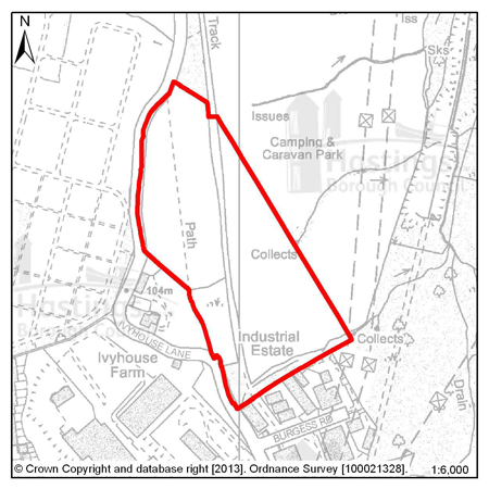
Figure 89: HOV11 – Ivyhouse Lane, Northern Extension
Site address: Ivyhouse Lane, Northern Extension
Allocated use: Employment; B use classes
Area: 5.80ha
Possible net capacity: 7,000m2
6.275 Site HOV11 – Ivyhouse Lane, Northern Extension is located on the northern edge of the urban area, accessed off The Ridge. It is an undeveloped site, which would form a natural extension to the existing Ivyhouse employment area.
6.276 The High Weald Area of Outstanding Natural Beauty extends to the edge of the built up area of Hastings and the site itself falls within it. Although the site has been allocated to meet strategic employment needs, any development must take full account of the site’s intrinsic value (including existing trees and hedges), the effect on its setting, and views of it from other parts of the AONB – in particular from the Rock Lane area from where it is visible.
6.277 The eastern boundary of the identified site is defined by the Borough’s administrative boundary rather than existing physical divisions on the ground and so, to be acceptable, a scheme should be designed such that it creates a new logical boundary. The Highway Authority may require the creation of an emergency access point onto Ivyhouse Lane further to the north of the site.
6.278 The site contains a well defined straight tree lined and sunken historic lane, which divides the site into two distinct areas. It is envisaged that the majority of development will take place in the southern part of the area either side of the historic lane, subject to new woodland planting and the retention and protection of existing trees. As well as the sunken lane, there are also a significant number of other trees within the site. The strength of the wooded character of the area provides a key characteristic feature upon which to develop a mitigation strategy. The size of the whole site is over 1 hectare, as advised by the Environment Agency, a Flood Risk Assessment is required. Development proposals will need to show consideration of the transport impact along The Ridge. Further advice on transport matters is available from East Sussex County Council.
6.279 Hastings Borough Council and Rother District Council have agreed to work together on a joint approach to treatment and management of the fringes of Hastings to secure a clearer definition of the urban boundary and to protect and enhance the rural character of the countryside that immediately abuts it, as well as better access to it. Work on this is expected to produce more detailed guidance (in the form of a Supplementary Planning Document) on joint urban fringes management which, once available, is likely to further inform the development requirements for this site.
6.280 An initial design brief has been prepared to guide potential schemes. (see Appendix A)
(2)
Policy
HOV11: Ivyhouse Lane, Northern Extension
Ivyhouse Lane, Northern Extension is allocated for employment (B use classes) development (potential gross floorspace 7,000m2).
The Council expects development proposals for this site to:
-
Demonstrate the conservation and enhancement of the Area of Natural Beauty by undertaking a Landscape Assessment, providing an appraisal of the impact on the Area of Outstanding Natural Beauty and demonstrate how adverse impact will be avoided;
-
Include an Ecological Constraints and Opportunities Plan, including specific reference to the presence of the adjacent Ancient Woodland, and incorporate conservation and mitigation measures as recommended by the Plan as appropriate;
-
Provide an arboriculture plan that demonstrates how existing trees on site will be integrated into the development, or how compensation will be made for their loss;
-
Include buffer landscaping to protect the amenity of the adjoining caravan site;
-
Include a Flood Risk Assessment and flood resilient design as appropriate to the outcome of that report;
-
contribute to improved transport infrastructure, particularly for pedestrians, cyclists and public transport, including the improvement of non-motorised access to the countryside;
-
Be supported by a Transport Assessment and Travel Plan. The Transport Assessment will need to take account of the site’s proximity to The Ridge. Proposals should indicate how the conclusions and recommendations of the assessment have been incorporated. Potentially development may be required to contribute to improvements on The Ridge;
-
Incorporate access by means of a spine road to join Ivyhouse Lane at the southern end of the site, and take into account off site improvements needed to Ivyhouse Lane as a result of this;
-
Incorporate new and enhance existing green infrastructure within the site.
The applicant will be expected take into account the wider area within Rother District when considering development proposals for this site.
Additional guidance for this site is also set out in a Design Brief in Appendix A
All Local Plan policies will be considered during the decision making process as appropriate.
Site reference: HOV12 - Land east of Burgess Road, Ivyhouse
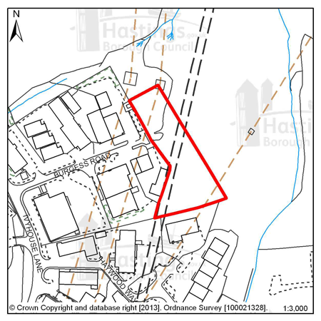
Figure 90: HOV12 – Land east of Burgess Road, Ivyhouse
Site address: Land east of Burgess Road, Ivyhouse
Allocated use: Employment; B use classes
Area: 0.51ha
Possible net capacity: 1,400m2
6.281 Site HOV12 - Land east of Burgess Road, Ivyhouse potentially forms part of a larger area extending beyond the Borough boundary into Rother. Combined, the full potential development area is up to 1.5 hectares. The area within Rother is allocated to Rother District Council’s adopted local Plan, but this will be subject to review when it prepares it’s new Development Management Plan.
6.282 The site is mainly wooded and located within the High Weald Area of Outstanding Natural Beauty. Development must take full account of the site’s intrinsic value, the effect on its setting, and views of it from other parts of the AONB. Ecological and landscape surveys of the site will be required. Development proposals will need to show consideration of the transport impact along The Ridge. Further advice on transport matters is available from East Sussex County Council. The site is traversed by high voltage transmission lines and so the utility provider should be consulted on any proposals.
6.283 As well as providing capacity for new employment floorspace, this development provides an opportunity to improve the ambiance and quality of the existing adjoining employment area.
6.284 Hastings Borough Council and Rother District Council have agreed to work together on a joint approach to treatment and management of the fringes of Hastings to secure a clearer definition of the urban boundary and to protect and enhance the rural character of the countryside that immediately abuts it, as well as better access to it. Work on this is expected to produce more detailed guidance on joint urban fringes management which, once available, is likely to further inform the development requirements for this site.
(2)
Policy
HOV12: Land East of Burgess Road, Ivyhouse
Land East of Burgess Road, Ivyhouse is allocated for employment (B use classes) development (potential gross floorspace 1,400m2).
The Council expects development proposals for this site to:
-
Include an Ecological Constraints and Opportunities Plan, including specific reference to the presence of the adjacent Ancient Woodland, and incorporate conservation and mitigation measures as recommended by the Plan as appropriate;
-
Provide an arboriculture plan that demonstrates how existing trees on site will be integrated into the development, or how compensation will be made for their loss;
-
Include a Landscape Assessment, providing an appraisal of the impact on the Area of Outstanding Natural Beauty and demonstrate how adverse impact will be avoided;
-
Assess the potential for a road link between Burgess Road and Haywood Way;
-
Be supported by a Transport Report. The Report will need to take account of the site’s proximity to The Ridge. Proposals should indicate how the conclusions and recommendations of the Report have been incorporated. Potentially development may be required to contribute to improvements on The Ridge.
The applicant will be expected take into account the wider area within Rother District when considering development proposals for this site.
All Local Plan policies will be considered during the decision making process as appropriate.
Focus Area 12: Clive Vale & Ore Village
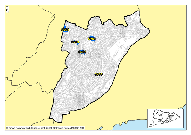
Figure 91: Focus Area 12 - Clive Vale & Ore Village
Introduction to Clive Vale & Ore Village Planning Focus Area
6.285 This Focus Area stretches up the Old London Road from the northern edge of the Old Town to the shopping centre at Ore. In the southern part of Clive Vale, grand Victorian villas enjoy spectacular sea views. To the north at Ore, the housing becomes part of the ‘ribbon development’ that took place in the nineteenth century in many English towns, along the main roads into the town centres.
6.286 Along this eastern edge, the area is bounded by Hastings Country Park, giving a semi-rural feel to houses where the gardens open out into countryside. The western edge is more urban and denser, with few open spaces. There is, however, a heavily wooded valley in the Upper Ore valley that is in multiple ownership, and we are working towards a sustainable future for it.
6.287 The area is well served by shops, doctors and other community facilities, although these are largely in the northern part, at Ore Village. But there are also other smaller local shopping parades at Mount Road and Harold Road, to the south of the area. In Ore Village, however, these services and facilities do result in issues of traffic build-up, especially on the busy A259, where parking is scarce and footpaths are narrow.
6.288 According to 2001 Census data, there are 7,500 inhabitants here, making it one of the more densely populated Focus Areas. It is relatively affluent, however, with 83% of the homes owned by their occupants (Census data). Around 7% of the working population claims Job Seeker’s Allowance (Department of Work and Pensions – Nomis statistics), but only about 2% of the housing is rented from Registered Social Landlords.
6.289 Apart from local shops, there is little employment in this area. The local Victorian trades that would once have been here have all but died out, beyond a few local car repairers and small workshops. In the Clive Vale part, there is a growing community of local artists and craftspeople who work out of home studios, but this is not a significant source of employment for local young people. This is a predominantly residential area, there are, however, good road and public transport links across the Borough and beyond to enable people to travel to work.
Our Vision for Clive Vale & Ore Village
6.290 The character of this area is dominated by Victorian terraces and villas, with distant and often dramatic views of the sea. Any new development schemes in this Focus Area would need to be sympathetic to the Victorian patterns and rhythm of development in the area.
6.291 Policy FA5 of the Planning Strategy outlines a range of 250-310 new homes to be provided here in the next 15 years. Because of the shortage of affordable housing in the area, we would encourage developers who wanted to provide a mix of social and affordable housing.
6.292 While Clive Vale & Ore Village are likely to remain largely residential, we would consider small-scale employment uses of existing or new property. These should not interfere with the predominantly residential character of the area, but ‘artisan’ trades – for example artist’s studios, specialist craft workshops, specialist niche food makers like bakers or confectioners – could fit with and enhance the area, and provide some local jobs. Tourist accommodation, in the form of small ‘boutique’ hotels, might also be suitable in the grander houses at the seaward end of the area.
6.293 So while we recognise that we cannot set any areas in cultural aspic, we need to recognise and preserve what is best about Clive Vale & Ore Village, both their architecture and their rare open spaces. But we need to encourage economic development too, especially in Ore Village centre, where regeneration investment is still much needed.
Residential, mixed use and other allocations for Clive Vale & Ore Village
| Site reference | Address |
Reason for allocation (including potential number of homes) |
Area (ha) | Does the site have a brief in Appendix A? |
|---|---|---|---|---|
| CVO1 | Victoria Avenue | Residential (51) | 0.77 |
|
| CVO2 | Land west of Frederick Road | Residential (29) | 0.60 |
|
| CVO3 | Rear of Old London Road | Residential (10) | 0.46 |
|
| CVO4 | Church Street | Residential (6) | 0.35 |
|
| CVO5 | 309-311 Harold Road | Residential (6) | 0.09 |
|
Table 14: Residential, mixed use and other allocations for Clive Vale & Ore Village
Site reference: CVO1 - Victoria Avenue
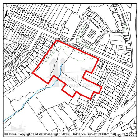
Figure 92: CVO1 – Victoria Avenue
Site address: Victoria Avenue
Allocated use: Residential
Area: 0.77ha
Possible net capacity: 51
6.294 Site CVO1 – Victoria Avenue is located at the northern end of the Ore Valley. It lies adjacent to a new Local Green Space, as identified on the Policies Map. The site is heavily wooded with steeply sloping gradients.
6.295 The site has particular ecological constraints, including the presence of protected species, together with the volume of trees and a stream running through the site. The strategic cycle network as identified on the Policies Map runs along the northern boundary of the site
6.296 Given the size and location of the site the Council will expect any scheme to support a varied housing mix and may be required to include specific housing for wheelchair users, and affordable housing will also be required as part of the mix. The site is also in an identified area that is lacking in quality children’s play provision and this will be required within a proposed scheme. Development proposals will need to show consideration of the transport impact along The Ridge. Further advice on transport matters is available from East Sussex County Council.
6.297 Southern Water has also indicated that there is currently insufficient sewerage or water main capacity to serve the site.
(1150)
Policy
CVO1: Victoria Avenue
The site at Victoria Avenue is allocated for residential development (possible net capacity 51 dwellings).
The Council expects development proposals for this site to:
-
Include affordable housing on site at 40% of the overall housing provision;
-
Include at least 2% of the total number of new homes as fully adapted dwellings for wheelchair users;
-
Include an Ecological Constraints and Opportunities Plan and incorporate conservation and mitigation measures as recommended by the Plan as appropriate;
-
Provide an arboriculture plan that demonstrates how existing trees on site will be integrated into the development, or how compensation will be made for their loss;
-
Provide for public access to the Local Green Space adjacent to the site;
-
Safeguard land to enable the implementation of the strategic network of cycle routes and contribute to its creation and management as appropriate;
-
Be supported by a Transport Statement. The Transport Statement will need to take account of the site’s proximity to The Ridge. Proposals should indicate how the conclusions and recommendations of the Statement have been incorporated. Potentially development may be required to contribute to improvements on The Ridge;
-
Provide a connection to the sewerage system at the nearest point of adequate capacity and/or make improvements to the infrastructure if necessary, as advised by Southern Water.
All Local Plan policies will be considered during the decision making process as appropriate.
Site reference: CVO2 - Land west of Frederick Road
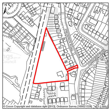
Figure 93: CVO2 – Land west of Frederick Road
Site address: Land west of Frederick Road
Allocated use: Residential
Area: 0.60ha
Possible net capacity: 29
6.298 Site CVO2 - Land west of Frederick Road is a brownfield site currently occupied by a single storey bungalow with various outbuildings and a paddock. There is no direct access onto Frederick Road, although a pedestrian and cycle access could be utilised through the existing driveway. Development proposals will need to show consideration of the transport impact along The Ridge. Further advice on transport matters is available from East Sussex County Council.
6.299 Southern Water has indicated that there is currently insufficient sewerage or water main capacity to serve the site. Given the size and location of the site the Council will expect any scheme to support a varied housing mix, including affordable housing.
(1)
Policy
CVO2: Land west of Frederick Road
Land west of Frederick Road is allocated for residential development (possible net capacity 29 dwellings).
The Council expects development proposals for this site to:
-
Include affordable housing on site at 25% of the overall housing provision;
-
Include an Ecological Constraints and Opportunities Plan and incorporate conservation and mitigation measures as recommended by the Plan as appropriate;
-
Contribute to the improvement of existing play facilities in the surrounding area;
-
Include vehicular access from Tuppeney Close and Cookson Close;
-
Be supported by a Transport Report. The Report will need to take account of the site’s proximity to The Ridge. Proposals should indicate how the conclusions and recommendations of the Report have been incorporated. Potentially development may be required to contribute to improvements on The Ridge;
-
Provide a connection to the sewerage system at the nearest point of adequate capacity and/or make improvements to the infrastructure if necessary, as advised by Southern Water.
All Local Plan policies will be considered during the decision making process as appropriate.
Site reference: CVO3 - Rear of Old London Road
Figure 94: CVO3 – Rear of Old London Road
Site address: Rear of Old London Road
Allocated use: Residential
Area: 0.46ha
Possible net capacity: 10
6.300 Site CVO3 – Rear of Old London Road is a relatively level site in an area of scrub and woodland surrounded by residential properties. The access to the site is relatively narrow so will need to be carefully managed. It lies adjacent to the Local Green Space in the Upper Ore Valley as identified on the Policies Map. The capacity potential of this site indicates that a Transport Report will be required, further advice is available from East Sussex County Council.
(1149)
Policy
CVO3: Rear of Old London Road
Rear of Old London Road is allocated for residential development (possible net capacity 10 dwellings). The Council expects development proposals for this site to:
-
Include affordable housing on site at 40% of the overall affordable housing provision;
-
Include an Ecological Constraints and Opportunities Plan and incorporate conservation and mitigation measures as recommended by the Plan as appropriate;
-
Provide an arboriculture plan that demonstrates how existing trees on site will be integrated into the development, or how compensation will be made for their loss;
-
Provide for public access to the Local Green Space adjacent to the site;
-
Incorporate proposals for upgrading the existing vehicle point;
-
Be supported by a Transport Report. Proposals should indicate how the conclusions and recommendations of the Report have been incorporated.
Additional guidance is also given in a design brief for this site in Appendix A.
All Local Plan policies will be considered during the decision making process as appropriate.
Site reference: CVO4 - Church Street
Figure 95: CVO4 – Church Street
Site address: Church Street Allocated use: Residential Area: 0.35ha
Possible net capacity: 6
6.301 Site CVO4 – Church Street comprises a small area of scrub and woodland that is relatively level. It presents an opportunity for a small amount of development, fronting onto Church Street. It is located adjacent to the Local Green Space in the Upper Ore Valley as identified on the Policies Map. The strategic network of cycle routes runs towards the south-east corner of the site. Development proposals will need to show consideration of the transport impact along The Ridge. Further advice on transport matters is available from East Sussex County Council.
(1149)
Policy
CVO4: Church Street
Church Street is allocated for residential development (possible net capacity 6 dwellings).
The Council expects development proposals for this site to:
-
Include affordable housing on site at 20% of the overall housing provision;
-
Include an Ecological Constraints and Opportunities Plan and incorporate conservation and mitigation measures as recommended by the Plan as appropriate;
-
Provide an arboriculture plan that demonstrates how existing trees on site will be integrated into the development, or how compensation will be made for their loss;
-
Provide for public access to the Local Green Space adjacent to the site;
-
Be supported by a Transport Report. The Report will need to take account of the site’s proximity to The Ridge. Proposals should indicate how the conclusions and recommendations of the Report have been incorporated. Potentially development may be required to contribute to improvements on The Ridge;
-
Safeguard land to enable the implementation of the strategic network of cycle routes and contribute to its creation and management as appropriate.
Additional guidance is also given in a design brief for this site in Appendix A.
All Local Plan policies will be considered during the decision making process as appropriate.
Site reference: CVO5 - 309-311 Harold Road
Figure 96: CVO5 – 309-311 Harold Road
Site address: 309-311 Harold Road
Allocated use: Residential
Area: 0.09ha
Possible net capacity: 6
6.302 Site CVO5 - 309-311 Harold Road is a relatively small site in a residential area, and represents an opportunity for residential redevelopment. There is a Local Wildlife Site nearby and there is the potential for significant ecology on site. This will need to be surveyed and understood as part of the development process. The capacity potential of this site indicates that a Transport Report will be required, further advice is available from East Sussex County Council.
(1)
Policy
CVO5: 309-311 Harold Road
309-311 Harold Road is allocated for residential development (possible net capacity 6 dwellings).
The Council expects development proposals for this site to:
-
Include affordable housing on site at 20% of the overall housing provision;
-
Include an Ecological Constraints and Opportunities Plan, including specific reference to the presence of the nearby Local Wildlife Site, and incorporate conservation and mitigation measures as recommended by the Plan as appropriate.
-
Be supported by a Transport Report. Proposals should indicate how the conclusions and recommendations of the Report have been incorporated.
All Local Plan policies will be considered during the decision making process as appropriate.
Focus Area 13: Hastings Country Park
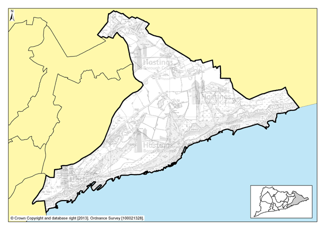
Figure 97: Focus Area 13 - Hastings Country Park
Introduction to the Hastings Country Park Planning Focus Area
6.303 Hastings Country Park is Hastings’ area of true countryside – and it is a very special area of countryside. Gradually acquired by the Borough Council over a century, it is made up of farmland, wooded glens and crumbling cliff tops that, together, make up an area of astonishing natural beauty; a wild, sea-edged landscape where rare plants and uncommon wildlife are present, in an environment little touched by development. This special character is recognised through the area’s legal status too. Declared a nature reserve in 2006, it is a Site of Special Scientific Interest (SSSI), and also a Special Area of Conservation (SAC), a designation which gives it special protection under European law. But it is not a wilderness; people have lived and worked here for thousands of years, and the area has a wealth of archaeology to prove this.
6.304 The Country Park also includes within its boundaries the Shearbarn holiday village, one of the primary tourist accommodation sites in the Borough, with camping grounds, caravans and log cabins high on the clifftops looking out over the sea, as well as the smaller Rocklands caravan park.
6.305 The Hastings Country Park Focus Area takes in slightly more than the Country Park nature reserve, including the curiously named ‘Bachelor’s Bump’ area at the north-east corner of the Borough. This is where most of the people in this area live, although there are a few small pockets of housing in the Country Park itself, mostly old agricultural housing, coastguard cottages, and the impressive Fairlight Place. Most of this housing is now in private ownership, although almost all of the Country Park is owned and managed by the Council. Even so, while this is the largest of our local Focus Areas by area, it is the smallest by population: only around 1,800 people live here, with over a quarter of them above retirement age (according to 2001 Census data).
6.306 The people who live in this Focus Area generally need to travel to access shops and services, as there are few within it. Road connections to Hastings Town Centre are good, and there are bus routes that pass through, and the presence of these is important to avoid problems of isolation.
6.307 This is an area where the natural environment is of paramount importance. That means maintaining the unspoilt character of the place for those who visit and live there, but more importantly, preserving the rare and sensitive habitats for the park’s astonishingly varied flora and fauna.
Our Vision for Hastings Country Park
(1) 6.308 Any development anywhere in the Country Park Focus Area would be tightly managed by existing planning restrictions that apply in SSSIs and the High Weald Area of Outstanding Natural Beauty (AONB), so we are not intending to identify much additional housing in this area to help us meet our overall housing target. Minor development outside of the Country Park itself could be considered, if it were unobtrusive and wholly in keeping with the character of the AONB and would not have an adverse effect on the integrity of the SAC. Within the park, any development would be limited to facilities that enhance the park environment and the ‘visitor experience’ – for example, a new visitor centre and café that fits with the Country Park’s aesthetic, or buildings needed for low level sustainable agriculture. Any development would need to be sensitively built and in keeping with the natural environment. We would envisage that any structures in the park would be environmentally sensitive in their methods of construction, use of renewable energy and water conservation. Environmentally sensitive projects for sustainable energy generation could also be considered. We would want to retain tourist accommodation at Shearbarn and Rocklands too, although any development there would also need to be environmentally sensitive, and limited entirely to tourist accommodation.
6.309 The potential of the Country Park to help local people, especially young people, gain experience in the crafts and skills that are used to maintain an area like this should not be overlooked. So while there would be little additional housing development, there is the potential for employment uses, largely of existing buildings, which fosters this kind of activity.