
Development Management Plan Revised Proposed Submission Version March 2014
(6) Section Two - General and Development Management Guidance
Part i) Overall Approach
Overall approach
2.1 The purpose of this Plan is to guide the determination of planning applications that are presented to the Council. Any scheme to be considered by the Council will be determined using both the Planning Strategy and its policies for overall sustainable growth in the Borough, and the policies in this Plan. In particular, specific consideration should be given to design, amenity and access that are appropriate to the scheme and to its locality. The solutions to these issues should be described to the Council as part of the application process.
2.2 The aim is to help individuals and businesses create good schemes with sufficient flexibility to achieve the best outcomes for themselves, their neighbours and the wider community.
2.3 If the relevant policies of both the Planning Strategy and this Development Management Plan are not adhered to in applications for planning permission then it is likely that that application will be refused or opposed.
(4) Policy LP1 – Considering Planning Applications
All development applications will be determined using national guidance (particularly contained in the National Planning Policy Framework) and the policies of the Hastings Local Plan.
The policies of the Local Plan are those contained within the Planning Strategy, Development Management Plan and any other Local Development Document produced (including Supplementary Planning Documents). The spatial extents of the policies are also shown on the Policies Map.
All policies of the Local Plan will be considered in the decision making process as appropriate to the proposal presented. As outlined in both national guidance and the Planning Strategy; the Council will make a presumption in favour of sustainable development that avoids adverse impacts upon the natural and built environment and increases social inclusion.
Some of the allocated sites in the Development Management Plan are supported by design briefs that will give additional detail to the associated site policy.
Affordable housing will be expected with every housing development site where there is a net increase in the number of homes. Affordable housing should be well-integrated with market housing in terms of site layout, appearance, detailed design, build quality and materials. With regard to housing mix, large scale development will be expected to deliver a mix of tenure and dwelling types within the scheme. On smaller schemes applicants will need to consider the tenure and housing mix in the locality and show how their development can contribute to increasing housing choices in terms of household sizes and the ages and incomes of possible residents.
When making planning decisions and advising applicants the Council will take advice, as appropriate, from partner organisations including Rother District Council, East Sussex County Council, the Environment Agency, Natural England or their successor bodies and utility providers to ensure that all development is acceptable and adequately serviced.
Development proposals will need to show careful consideration of the transport impact onto and off locally important routes, particularly along The Ridge. The delivery of appropriate and effective mitigation will be required in conjunction with the proposed development coming forward. The traffic impact will be monitored over the Plan period and data will be available from the County Council’s transport monitoring programme.
2.4 Part of the planning application process includes the requirement for supporting documents to be provided with an application before it can be validated (i.e. accepted as a complete and comprehensive package of application information that is worthy of consideration by the Council). To view what is required in support of an application please see the validation checklist available at: http://www.hastings.gov.uk/environment_planning/planning/info_advice/app_forms_guidance_notes/
Householder applications
2.5 The majority of enquiries to the Council about planning issues, concern homes; often the questions relate to whether a proposal requires permission. Not all changes require planning permission; there are some things that occupiers/householders are allowed to do (including within the curtilage or garden) without the need for planning permission2.
2.6 To find out if you need planning permission please visit: http://www.planningportal.gov.uk or, for further information, contact Hastings Borough Council’s Development Management Team by telephone on 01424 451090 or email dcenquiries@hastings.gov.uk.
2.7 The Council has information and advice available online, http://www.hastings. gov.uk/environment_planning/planning/info_advice/app_forms_guidance_notes/ and has produced a Supplementary Planning Document (SPD), specifically for householder applications concerning design and sustainability. This is available at: http://www.hastings.gov.uk/environment_planning/planning/localplan/spd/.
2.8 Planning application forms, guidance notes and validation checklists are available at: http://www.hastings. gov.uk/environment_planning/planning/info_advice/app_forms_guidance_notes/.
Part ii) General Guidance Policies
Design
2.9 Urban design is about making connections between people and places. It brings together the many strands that make up a place: environmental stewardship, social equity and economic viability. The aim is to create places with distinct beauty and identity. Urban design is derived from planning and policy writing, architectural design, development economics, engineering and landscape. But it goes beyond the single aspect of each of these disciplines and it draws them together creating a vision for a building, site or area that is as much about the usability and sustainability of development as it is purely about aesthetics.
2.10 When development does take place, it is important that it has regard for local character and it achieves a good standard of design. The use of resources and impacts on the environment and the community should also be considered. Allowing some flexibility, however, in the form a development might take, can sometimes result in more imaginative and innovative schemes being built.
2.11 There is much guidance available on the subject of design and the Council will have regard to this where appropriate, in particular from The Design Council. It is important to note that design is a dynamic and changing field, and it is not felt appropriate to write into policy now, what might become outdated during the life of this Plan. Instead plans submitted to the Council should show consideration, appreciation and inclusion, where appropriate, of the latest design guidance and best practice, but crucially, set within the context of Hastings the Borough, but also the locality where a scheme is proposed.
2.12 Chapter 6: Developing Sustainable Communities in the Planning Strategy describes what Hastings Borough Council’s expectations are, especially in terms of carbon and energy efficient buildings and construction. The following policy, DM1, should be read with particular reference to Policies of that chapter.
2.13 Policy SC7 is of particular importance to consider as it requires that the proposals are in accordance with the Strategic Flood Risk Assessment (SFRA) and that they are subject to the sequential test, seeking to avoid development in flood risk areas before considering mitigation measures.
2.14 Outlined in the Planning Strategy, Policy CI1, are the Council’s likely infrastructure requirements to support new development and these should also be integrated into the design of proposals at an early stage, together with, where appropriate, the inclusion of children’s play facilities in accordance with Policy CI3. For further information on the Council’s expectations for community infrastructure please see Chapter 10 of the Planning Strategy.
2.15 As well as the Policy DM1 (and where appropriate DM2) of this plan, the potential impact of a scheme on the built and historic environment should be considered with reference to the environmentals policies of the Planning Strategy, and Part iv) Historic and Natural Environment of this Plan.
2.16 Policies H1, H2 and H3 within the Planning Strategy, should also be read in conjunction with Policy DM1. For further information on the Council’s expectations for housing please see Chapter 8 of the Planning Strategy.
(1) 2.17 In addition to the more general issues described up to this point, in Hastings, because of its unique combination of heritage, ecology, topography, townscapes and landscape it is also important to consider:
- The selection of appropriate materials – these should have regard to the area’s character and the Council’s objectives for sustainability. This would include, where appropriate, the re-use of materials and
- The use of plant and tree species for landscaping and border treatments, appropriate to the local area.
- Views of a development – these should be considered both from close by and from a wider area. The particular topography of the Borough means that there are many areas that are visually prominent, but there are also those areas that have an unexpected prominence; there can be ‘glimpse views’ of places like the castle and these should be given the same consideration. The impact upon protected areas of countryside must also be considered, like the Country Park and the nearby High Weald Area of Outstanding Natural Beauty.
- Particular attention should be given to the ‘gateways’ into developments to reinforce a sense of character and distinctiveness.
(1) 2.18 In order that the overall design of a proposal is considered as well as all the various aspects that are required to achieve good design, Policy DM1 lists those things, in no particular order, that will be considered important to achieve a good and appropriate scheme. Policy DM2 considers the specific case of proposals for telecommunication installations.
(2) Policy DM1 – Design Principles
All proposals must reach a good standard of design, which includes efficient use of resources, and takes into account:
- Protecting and enhancing local character;
- Showing an appreciation of the surrounding neighbourhood’s historic context, street patterns, plot layouts and boundaries, block sizes and scale, height, massing and materials;
- Good performance against nationally recognised best practice guidance on sustainability, urban design and place-making, architectural quality and distinctiveness;
- The layout and siting of buildings to make efficient use of land, the orientation of frontages to achieve attractive streetscapes and to best take into account the effects of solar gain;
- An assessment of visual impact, including the height, scale, and form of development that should be appropriate to the location, especially given the complex topography of the Borough and the need, in some instances, to consider the visual effect from key viewpoints. This is particularly important when there are potential impacts upon areas of heritage and/or landscape value as outlined in the Planning Strategy (this could include a landscape assessment where appropriate).
Supplementary Planning Documents provide further detail to this policy.
Relationship to the Planning Strategy (2014)
Policies:
SC1: Overall Strategy for Managing Change in a Sustainable
Way SC2: Design and Access Statements
SC3: Promoting Sustainable and Green Design SC4: Working
Towards Zero Carbon Development
SC5: District Heating Networks and Combined Heat and Power
Systems SC7: Flood Risk
EN1: Built and Historic Environment EN2: Green Infrastructure
Network
EN3: Nature Conservation and Improvement of Biodiversity EN7:
Conservation and Enhancement of Landscape
EN8: Open Spaces – Enhancement, Provision and Protection H1:
Housing Density
H2: Housing Mix
H3: Provision of Affordable Housing
CI1: Infrastructure and Development Contributions CI3:
Children’s Play Provision
Telecommunications technology
2.19 Modern telecommunications systems have grown rapidly in recent years with more than two thirds of the population now owning a mobile phone. Mobile communications are now considered an integral part of the success of most business operations and individual lifestyles. With new services demand for new telecommunications infrastructure is continuing to grow. We are keen to facilitate this expansion whilst at the same time minimising any environmental impacts. It is our policy to reduce the proliferation of new masts by encouraging mast sharing and siting equipment on existing tall structures and buildings.
(1) Policy DM2 – Telecommunications Technology
In accordance with Government advice, if a proposed installation meets the International Commission on Non-Ionising Radiation Protection (ICNIRP) guidelines for public exposure then it will not be necessary to consider further health aspects and concerns.
Prior approval for the siting and appearance of antennae will be given and full planning permission granted for telecommunications installations provided that the following criteria are met:
- The siting and appearance of the proposed apparatus and associated structures should seek to minimise impact on the visual amenity, character or appearance of the surrounding area in accordance with Policy DM1, above, and where appropriate HN1;
- If on a building, apparatus and associated structures should be sited and designed in order to seek to minimise impact to the external appearance of the host building;
- If proposing a new mast, it should be demonstrated that the applicant has explored the possibility of erecting apparatus on existing buildings, masts or other structures. Such evidence should accompany any application made to the Council;
- If proposing development in a sensitive area, the development should not have an unacceptable effect on areas of ecological interest, areas of landscape importance, archaeological sites, conservation areas or buildings of architectural or historic significance;
- When considering applications for telecommunications development, the Council will have regard to the operational requirements of telecommunications networks and the technical limitations of the technology.
Relationship to the Planning Strategy (2014)
Policies:
SC1: Overall Strategy for Managing Change in a Sustainable
Way SC2: Design and Access Statements
SC7: Flood Risk
EN1: Built and Historic Environment EN2: Green Infrastructure
Network
EN3: Nature Conservation and Improvement of Biodiversity EN7:
Conservation and Enhancement of Landscape
EN8: Open Spaces – Enhancement, Provision and Protection
Amenity
2.20 Amenity is a broad term that can encompass protection from unacceptable impacts on an area as a whole or on neighbouring occupants, for example avoiding loss of privacy, overshadowing and loss of daylight.
2.21 Amenity also includes layout and proportions (internal and external) of buildings. Amenity is a term that is also used to describe the spaces between buildings, the public spaces that, when well maintained, help to increase a persons sense of wellbeing. Amenity, then, is a crucial issue to consider with proposals and Policy DM3 offers guidance towards the Council’s expectations.
2.22 The management of the spaces between buildings can also help to contribute to objectives of environmental sustainability. Green infrastructure, policy EN2 of the Planning Strategy, is a crucial part of development proposals that can safeguard biodiversity, natural features and wildlife habitats.
2.23 Despite differences in size, tenure and density, it is important that all homes in the Borough are of high quality. This is, indeed, also Objective 2 of the Planning Strategy and, as such, amenity is closely linked to policies SC1, SC2, H1 and H2 of the Planning Strategy.
2.24 As well as the design Policy DM1, Policy DM3 also provide guidance, in no particular order, towards what the Council believes to be a decent home that safeguards the amenity of its inhabitants, neighbours and the local community.
2.25 The Council may deem it necessary to reference national guidance on housing quality, particularly that from the Homes and Communities Agency (HCA), who cite the Housing Quality Indicators of 2008 as a good grounding for assessing the standard of proposed new homes. As with design, this is a dynamic and changing subject area. It is, however, considered that a standard for internal space that is appropriate in new build housing is to provide at least a minimum of liveable space. The management and orientation of that space can be negotiated on a site specific basis.
(3) Policy DM3 – General Amenity
In order to achieve a good living standard for future users of proposed development and its neighbours it should be demonstrated that amenity has been considered and appropriate solutions have been incorporated into schemes. Permission will be given for development where:
- The use of the scale, form, height, mass, and density of any building or buildings, reduces or avoids any adverse impact on the amenity (privacy, over shadowing, loss of daylight) of neighbouring properties;
- There is adequate space for storage of waste and the means for its removal (where appropriate, turning areas for refuse vehicles). This includes provision for the general management of recyclable materials. Space will also be required for necessary servicing areas, ancillary structures and landscaping;
- There is a means of landscaping that contributes to crime prevention; a permeable and legible green infrastructure network of routes and spaces to create a public realm that is attractive, overlooked and safe;
- Considerate design solutions for the spaces between and around buildings are shown. This should respect the character of the surroundings; a well-designed scheme in terms of private, semi-private and public open space, to include, where appropriate, the provision of public art;
- Arrangements are in place for the future maintenance of any public areas;
- Dwellings are designed to allow residents to live comfortably and conveniently with sufficient internal space. The guidelines for minimum internal floor areas are: 1 bedroom/2 person 51m2; 2 bedroom/3 person 66m2; 2 bedroom/ 4 person 77m2; 3 bedroom/5 person 93m2; 4 bedroom/6 person 106m2;
- Appropriate levels of private external space are included, especially for larger homes designed for family use (dwellings with two or more bedrooms). In respect of proposed family dwellings the Council would expect to see the provision of private garden space (normally at the rear), of at least 10 metres in length;
- It can be adequately demonstrated that there is no safety risk to the public, and that development is appropriately protected from any existing facilities that may affect amenity; for example busy roads, waste water treatment works etc.
Relationship to the Planning Strategy (2014)
Policies:
SC1: Overall Strategy for Managing Change in a Sustainable
Way
SC2: Design and Access Statements EN2: Green Infrastructure
Network H1: Housing Density
H2: Housing Mix
Access
2.26 When new development is proposed, the ways that people move on and off and through the site are important considerations. The impact on existing transport networks from completed schemes is also an important matter. Particular consideration might need to be given to roads in the town that are, as yet, un-metalled, as further development that uses these roads for access could create a situation that would lead to their deterioration.
2.27 Design and Access Statements are a prerequisite of most planning applications, and are required by Policy SC2 of the Planning Strategy. They should explain how proposals are capable of successful integration onto a particular site. Consideration should go beyond the strict boundaries of the site in order to appreciate how people move between different places and how various uses connect together.
2.28 Where existing transport infrastructure is inadequate to meet the needs of new development, planning conditions or development contributions will be used to ensure that developments are made acceptable through securing the provision of necessary improvements.
2.29 Whilst acknowledging its importance to modern life, designs that put further reliance on travel by private car alone should be discouraged. The provision of car parking in developments must not lead to vehicles having an overbearing effect on the streetscape. Policy T3 of the Planning Strategy advocates the promotion and increased use of sustainable forms of transport and to support this, proposals should include clear access to and routes for alternative modes of transport to the car. This will also support the strategic cycle network through Hastings Borough. Proposals for larger schemes are likely to require travel plans in accordance with Policy T4 of the Planning Strategy. For further information on the Council’s transport infrastructure please see Chapter 11 of the Planning Strategy.
2.30 Parking provision in connection with a specific development is the responsibility of the developer. East Sussex County Council has produced guidance that has now been adopted by Hastings Borough Council as a Supplementary Planning Document (SPD). This sets out the thresholds for provision of parking spaces and is available at: http://www.hastings.gov.uk/environment_planning/planning/localplan/spd/parking_provision/
2.31 The Council will apply the Parking Provision in New Developments SPD when considering development proposals. There is also national guidance on access issues available, such as, from the Design Council and the Homes and Communities Agency. The Council will also have regard to this advice where appropriate.
2.32 Policy DM4 below, describes, in no particular order, those matters that the Council expects to see included in development proposals.
(1) Policy DM4 – General Access
Attention must be paid, not only to the access onto the site, but also access within all parts of any resultant development. Development schemes should include:
- Safe access into (and within) the development for all users and be accompanied, as appropriate, by a Transport Assessment Statement or Report as appropriate. Hastings Borough Council will take advice from the local Highways Authority (East Sussex County Council) when taking decisions on this point;
- The enhancement and promotion of public transport provision pedestrian and cycle access, and where appropriate the inclusion of pedestrian and cycle routes into and through sites to aid connectivity;
- When considering the layout of a site, provision for non-car based modes of transport are shown to be clearly included;
- The parking standards set out in the adopted Parking Provision in New Developments Supplementary Planning Document (or any future replacements);
- Where appropriate, for development which would generate additional traffic on an un-metalled carriageway, through a legal agreement, the bringing of the road up to an acceptable standard and for it to remain private or to be brought up to an adoptable standard and adopted by the HighwayAuthority;
- Good accessibility for all, especially for people with a physical or sensory impairment;
- The installation of a powered lift system to all floors, for any new buildings (except a single dwelling house) of three storeys or more. The lifts should be designed to allow for their use by disabled people and particularly those who use wheelchairs;
- Good performance against nationally recognised best practice guidance on internal building design and layout.
Relationship to the Planning Strategy (2014)
Policies:
SC2: Design and Access Statements
T3: Sustainable Transport
T4: Travel Plans
Ground conditions
2.33 Where a site is affected by contamination or instability, responsibility for a safe development rests with the developer and local authorities cannot refuse planning permission on these grounds alone. National planning guidance states that to prevent unacceptable risks from pollution and land instability, local authorities should ensure that the development is appropriate for its location and that the site itself is suitable for its new use taking account of ground conditions and land instability (paragraphs 120 and 121 of the National Planning Policy Framework - NPPF).
2.34 The NPPF also requires planning authorities to seek to ensure that when remediation measures are undertaken, the land should, post development, not be capable of being determined as ‘contaminated land’ under Part IIA of the Environmental Protection Act 1990. (Paragraph 121). The Planning Authority therefore needs to be satisfied that, where it is necessary, ground conditions and contaminants have been fully taken into account in proposals for development.
2.35 Conditions will be applied to planning decisions that will prevent the commencement of development until the Council is satisfied that ground conditions and any identified remediation or mitigation measures are acceptable for it to begin. These conditions will be in accordance with Policy DM5 below, and should be read in conjunction with Policies SC1, and where appropriate SC2, of the Planning Strategy.
(4) Policy DM5 – Ground Conditions
In order to protect human health and water quality, assessments of existing ground conditions should be undertaken, and details submitted to the Local Planning Authority under the following circumstances:
Land instability
a) On land potentially subject to instability (such as steeply sloping sites or in areas with a history of land instability), convincing supporting evidence (from a relevant and suitably qualified professional) must be supplied before development takes place. This evidence is to show that any actual or potential instability can be overcome through appropriate remedial, preventative or precautionary measures. At the application stage, for those sites with a recorded history of instability, information about the extent of remediation and/or mitigation measures will be required. Any further detail that may be required will be conditioned.
Contaminated land
b) Proposals for sites known or suspected to be contaminated (through previous or historical uses) must be submitted with suitable ground investigation reports. New developments within 250 metres of a landfill site or land suspected of contamination will require investigation and demonstration that development is acceptable. At the application stage information about the extent of remediation and/or mitigation measures will be required. Any further detail that may be required will be conditioned.
Relationship to the Planning Strategy (2014)
Policies:
SC1: Overall Strategy for Managing Change in a Sustainable
Way
SC2: Design and Access Statements
Pollution and hazards
2.36 Where a development has the potential to create pollution to land or water environments, it is important to consider this at an early stage to keep its effects to a minimum. Lighting, noise, odour, hazardous and non-hazardous substances and airborne particulates are all potential pollutants and their impact in new development must be properly assessed. Airborne pollutants are a particular issue in the Air Quality Management Area in Bexhill Road/Bulverhythe.
2.37 There are a number of water courses and wetland habitats in Hastings and, of course, it is next to the sea. Development will be expected to avoid adverse impacts to water quality and applications will be expected to be accompanied by surveys and mitigations measures where appropriate. Advice will be sought as necessary from Natural England and/or the Environment Agency. To help protect ecology, and the viability of important local businesses, the Council will seek to preserve local sea water quality and further information on this can be obtained from the Inshore Fisheries Conservation Authority (IFCA).
2.38 Sometimes pre-existing sources of pollution or specific hazards need to be taken into account when proposals are made, in these cases the Health and Safety Executive (HSE) are able to advise potential applicants about these. The Council will use the advice of the HSE in its decision making process.
2.39 Policy DM6 sets out the Council’s expectations for minimising of pollution from development. This policy should be read in conjunction with Policy SC1, and where appropriate, SC2 of the Planning Strategy.
Policy DM6 – Pollution and Hazards
In order to protect human health and water quality planning permission will only be granted for development providing:
- External lighting proposals avoid unnecessary light pollution beyond the specific area intended to be lit;
- The level of airborne pollutants caused by the proposed development does not exceed statutory guidelines, unless appropriate mitigation measures are agreed;
- Noise and odour that is detrimental to neighbouring and/or local amenity is kept to a practical minimum; appropriate means of assessment may be required;
- Appropriate pollution control measures are incorporated where necessary to protect the quality of both ground and surface waters;
Applicants will be required to supply convincing supporting evidence (from a relevant and suitably qualified professional) that any actual or potential pollution can be overcome through appropriate remedial, preventative or precautionary measures;
Where appropriate, the Local Planning Authority will consult the Health and Safety Executive on applications near “notifiable installations” (examples include high pressure gas mains and over head- power cables). The determining factors are the distance, risks and nature of the proposals.
Relationship to the Planning Strategy (2014)
Policies:
SC1: Overall Strategy for Managing Change in a Sustainable
Way
SC2: Design and Access Statements
Water resource availability
2.40 The use and management of water resources (rivers, lakes, wetlands, underground aquifers etc) in Hastings and how developments might affect them are matters that need to be taken into consideration in accordance with guidance from the Environment Agency.
2.41 Flood Risk as an issue is covered by Policy SC7 of the Planning Strategy.
2.42 The availability of water resources and the impact of increased abstraction on environmental water needs will be taken into account in the determination of development proposals. A licence may be required for water abstraction and this should be sought from the Environment Agency.
2.43 The Council will work with applicants and advice will be taken as necessary from the Environment Agency and/or Natural England about the impact to the availability of water. The impacts could be to the needs of navigation, fisheries, recreation and nature conservation.
2.44 Policy DM7 sets out the expectation of the Council in the specific circumstances of development that has the potential to have an impact on the availability of water resources. The quality of water resources (i.e. pollution by hazardous and non-hazardous substances) is dealt with in Policy DM6 above.
Policy DM7 – Water Resource Availability
The protection of ground water sources and reserves (rivers, lakes, reservoirs and underground aquifers) is important. Therefore, development will be permitted that can demonstrate the availability of ground water resources will not be threatened. Development will not be permitted within areas where there is significant risk to ground water resources (such as Source Protection Zones) in accordance with the records of the Environment Agency.
Development may have a local impact upon water resources in Hastings. In considering planning applications, the Council will have regard to the impact of the development on overall availability of water in the town. This particularly will be the case where the end user will have an abnormally high water consumption, for example, as part of a manufacturing process.
Consideration will also be given to possible environmental effects of development. The Council will seek to ensure that development does not cause unacceptably low river flows or the drying out of wetlands on or off the site. In order to assess the impact of a development on water resources, in appropriate cases the Council will seek advice from the relevant body, the Environment Agency or Southern Water.
Relationship to the Planning Strategy (2014)
Policy:
SC1: Overall Strategy for Managing Change in a Sustainable
Way
Part iii) Housing and the Community Policies
Conversion of dwellings
3.1 It is an aim of the Planning Strategy to both increase the supply of new dwellings and at the same time promote an appropriate mix of dwellings types and sizes within the Borough with an emphasis on increasing the supply of larger and family sized units. Policy SC1 of the Planning Strategy seeks to meet the housing needs of all sectors of the community. This can be achieved through new development and/or the conversion of existing dwellings. The conversion of large single dwelling houses into flats can provide a useful source of new dwellings, but at the same time care needs to be taken to ensure that valuable family housing is not lost or, that as a result of inappropriate conversions poor living environments are created either for the occupiers of such units or existing neighbouring residents. Policy H2 of the Planning Strategy requires housing developers to have regard to housing mix in new development. Even in a conversion scheme there is the potential to provide good quality family accommodation.
3.2 Policy HC1 supports the Planning Strategy policies with regard to housing mix and quality. Judgements about a house and whether it should be retained as a single dwelling will be made based on the existing number of bedrooms within the dwelling, and amenity factors such as whether the proposed layout of rooms reflects, as far as practicable, the existing room layout – the subdivision of floorspace to create internal rooms to provide facilities will not normally be acceptable for example. Also, the desirability, particularly in Conservation Areas, and necessity (in respect of family dwellings) of preserving front and rear gardens and other landscape features will be important.
3.3 This policy should be read in conjunction with Planning Strategy policies SC1, H2 and H4 and the general guidance polices in Part ii) of this Plan, particularly DM1 and DM3.
(2) Policy HC1 – Conversion of Existing Dwellings
To support the provision of quality homes and dwelling mix, converting all or part of a dwelling to another use or into multiple dwellings will normally be permitted provided that;
- The building can no longer be retained in its entirety for single family housing occupancy;
- It would not include significant extension(s) or significant changes to room layouts to achieve an adequate standard of accommodation;
- It would not involve the self-containment of basement areas or other parts of any property having inadequate light or low ceilings or which would result in a poor outlook from main windows; and
- It would make adequate provision for refuse storage.
Relationship to the Planning Strategy (2014)
Policies:
SC1: Overall Strategy for Managing Change in a Sustainable
Way
H2: Housing Mix
H4: Houses in Multiple Occupation
Residential institutions and student halls of residence
3.4 Where residential institutions or student accommodation are proposed a reasonable balance has to be achieved between the needs of the prospective occupants and the local amenity of existing residents.
3.5 Residential Institutions (Use Class C23) are those places where people live with an element of on-site care provided for them. Examples of these are: residential care homes, nursing homes, boarding schools, residential colleges and training centres.
3.6 Residential accommodation for students can take a variety of forms and consequently fall within a number of planning use classes. Policy HC2 applies to proposals for residential institutions and student halls of residence.
3.7 A mixture of housing and other types of residential accommodation in a given locality can contribute towards sustainable communities, but it is also important that the specialist accommodation described here is located appropriately.
3.8 Any proposal for a residential institution or student halls of residence must demonstrate that the new development reflects the local character and meets the specific requirements of prospective inhabitants; in accordance with the general guidance policies in Part ii) of this Plan. Design, access and location in relation to services and facilities are of particular importance, but the weight to be accorded to each criterion will depend upon the precise nature of the proposals. It should also be noted that there are no permitted changes of use away from Residential institutions (Use Class C23) or halls of residence and as such any proposed change will require a planning application.
3.9 The needs of prospective inhabitants should be set out in the submitted planning application. For example, a proposal for a home for elderly residents will have different requirements to that of student halls, and these requirements will be different again if a specialist home or institution is proposed for long term ill people. Scheme promoters should assess the particular needs of their project and explain how identified issues have been resolved in submitting their planning application. This will support Policy SC1 of the Planning Strategy, and should be set out in design and access statements as required by Policy SC2. To support the delivery of the Council’s aspirations for sustainable communities, Policy HC2, below, will address those matters that the Council consider of particular importance in considering planning applications for residential institutions and student halls of residence. Policy HC2 should be read in conjunction with the general guidance policies in Part ii) of this Plan, particularly DM1, DM3 and HC1 above.
Policy HC2 – Residential Institutions and Student Halls of Residence
Planning applications for residential institutions (including for the elderly, infirm and physically and sensory impaired) and for student halls of residence should comply with the following criteria:
- The site should be appropriate in terms of accessibility for its prospective residents (particular assessment may be required for institutions proposed for disabled people). Parking arrangements should reflect the needs of residents, particularly disabled people, with adequate space also available for servicing and amenity space;
- Changing the use of an existing building should not detrimentally affect its character or setting;
- Account may be taken of existing accommodation in the locality to ensure an adequate residential mix remains for all sectors of the community.
Relationship to the Planning Strategy (2014)
Policies:
SC1: Overall Strategy for Managing Change in a Sustainable
Way
SC2: Design and Access Statements
Community facilities
3.10 To support the aspirations of the Planning Strategy to achieve sustainable communities, proposals that impact upon an existing community facility or propose a new one will require specific consideration.
3.11 Community facilities provide for the health and wellbeing, social, educational, spiritual, recreational, leisure and cultural needs of the community. The communities of the Borough are set to grow and as such these facilities will need to not only provide for the needs of the existing population but also for more people as they move to the area.
3.12 For the purposes of this policy, a community facility includes any building used by local people for community purposes. This can include community halls, meeting rooms, youth centres and church halls. Other community facilities, such as open spaces, are dealt with in section 2, Part iv) of this Plan – Historic and Natural Environment Policies.
3.13 It is important that if new facilities are proposed they are appropriate to their surroundings and do not adversely impact upon the amenity of their neighbours. It is also important that the value of existing facilities is appreciated and that their retention or appropriate replacement is an early consideration in any proposed scheme.
3.14 Policy HC3 gives guidance on the siting of community facilities and the consideration of proposals involving the change of use, or the removal of such facilities. Depending on the particular circumstances, the best option may be to retain a facility, to allow an alternative solution or to close an economically unviable facility. An unviable community facility will be determined on a case by case basis.
Policy HC3 – Community Facilities
Proposals for the provision of community facilities will be granted planning permission, provided that the development is acceptable in terms of location, design, access and impact on the locality, and is in general conformity with other policies of this Plan, in particular DM1 and DM3.
Planning applications involving the loss of a community facility will only be permitted where it can be demonstrated that the existing community use is no longer required, not viable, or proposals for its replacement are included in the application.
Relationship to the Planning Strategy (2014)
Policy:
SC1: Overall Strategy for Managing Change in a Sustainable
Way
Part iv) Historic and Natural Environment Policies
Historic Environment
Heritage assets
4.1 Designated heritage assets include:
- Scheduled monuments
- Listed buildings
- Conservation areas
- Registered historic parks and gardens
- World heritage sites
- Protected wreck sites
- Registered battlefield sites.
They are the buildings, monuments, sites, places, areas and landscapes that have statutory heritage significance and so merit special consideration in planning decisions.
(1) 4.2 Each of the 18 conservation areas in Hastings and St Leonards has a distinct character. In addition to seeking a high standard of development in conservation areas, the Council will also seek to preserve the distinctive character of the different areas of the town, by ensuring that new designs and materials are appropriate to the character of each of the specific conservation areas.
The conservation areas (their locations and extents are shown on the Polices Map):
- Old Town
- Burtons’ St leonards
- Blacklands
- St Leonards West
- St Leonards East
- St Leonards North
- Warrior Square
- White Rock
- Cornwallis Gardens
- Grosvenor Gardens
- Magdalen Road
- Eversfield Place
- Markwick Terrace
- Springfield Road
- Tilington Terrace
- Town Centre
- Kings Road
- Ore Place
(1) 4.3 Policy EN1 of the Planning Strategy, describes how the Borough has a very rich and varied historic environment. The policy also outlines how there is a presumption in favour of the conservation of these assets and their setting. The policies of the Development Management Plan support Policy EN1 of the Planning Strategy by providing details about what is likely to be required in support of planning applications that have an impact upon heritage assets. This will ensure that we preserve the best of the historic and architectural legacy of Hastings and St Leonards, for future generations to enjoy. It is important that the potential impacts of any scheme are considered at an early stage by the applicant. This is especially important when considering the significance and setting of heritage assets. Full assessment of the significance of the heritage assets and consideration of the heritage impacts of various design options are a prerequisite of developing proposals that will have an acceptable impact on the historic environment. This evaluation process should be completed before detailed plans for a scheme are drawn up.
4.4 Listed building consent is required for proposed works in respect of listed buildings and scheduled monument consent for developments affecting scheduled monuments (both classed as heritage assets), and these regimes are not dealt with in this Local Plan4. The policies of this Plan are for guidance in judging applications for planning permission in relation to heritage assets. The policies do, though, deal with the impact of development on the setting of all heritage assets including conservation areas, listed buildings and scheduled monuments. According to national guidance, a key requirement of any proposal that may affect heritage assets is that the applicant demonstrates a detailed understanding of the significance of the heritage assets and also of the implications of their proposed development on both the heritage asset(s) and their setting.
4.5 The significance of a heritage asset is a measure of its cultural value to this and future generations because of its heritage interest. That interest may be archaeological, architectural, artistic or historic. Significance derives not only from a heritage asset’s physical presence, but also from its setting. The impact that a proposed development might have on the historic environment will be better understood when the significance of any heritage assets affected has been identified. Once the significance is identified, it should then be easier to assess the likely implications of various design options on the elements that make up that significance. Appropriate design solutions or mitigation measures can then be included within a proposed scheme, to ensure that the significance of the heritage asset is sustained and enhanced through the development process.
(1) 4.6 Through the implementation of these policies, the Council will encourage applications for good quality and sensitive new development for these special places that will, over time, help to sustain and enhance their heritage value.
4.7 Applicants will need to demonstrate their understanding of the local character of the area of the Borough within which they hope to develop. This will include the impact of the local topography on views towards the development and the impact of their proposals on the setting of heritage assets.
4.8 The setting of a building may be provided by the other buildings and landscape that immediately surround it. However, in a hilly town, like Hastings, we must also consider that a new development some streets away, or across the other side of the valley, may also significantly affect the setting of a heritage asset.
4.9 A full assessment in the form of a Heritage Asset Statement, of the impact of the proposals (including changes of use), on all affected heritage assets will be required as part of the planning application submission. East Sussex County Council provides a service to help applicants complete Heritage Asset Statements. Further information is available directly form East Sussex County Council at: county.archaeology@eastsussex.gov.uk.
4.10 The County Council also has information about heritage assets including a Historic Environment Record (HER) that can be accessed and should be used to inform schemes that affect the significance and setting of heritage assets. Further information is available directly form East Sussex County Council at: county.archaeology@eastsussex.gov.uk.
4.11 To view what is required in support of an application that may impact upon a heritage asset please see the validation check list available at: http://www.hastings.gov.uk/environment_planning/planning/info_advice/app_forms_guidance_notes/.
4.12 All applications put before the Council should demonstrate how they comply with Policy DM1 of this Development Management Plan (and where appropriate, those policies of the Planning Strategy that are referenced with Policy DM1, e.g. Policy SC3).
(1) Policy HN1 – Development Affecting the Significance and Setting of Designated Heritage Assets (including Conservation Areas)
Applications that have the potential to impact upon the significance of designated heritage assets (including conservation areas) will be assessed against the following criteria, to ensure that the proposed development sustains and enhances the significance of the heritage asset:
- The historic context, street patterns, plot layouts and boundary treatments, green space and landscaping, site levels, block sizes, siting, scale, height, massing, appearance, materials and finishes in relation to the heritage assets.
- Good performance against nationally recognised best practice guidance on development in relation to heritage assets, including building in context, setting and views, architectural quality and local distinctiveness.
Permission will be given for those schemes that show a full understanding of the significance of the asset and convincingly demonstrate how their chosen design sustains and enhances the significance of any heritage assets affected (including conservation areas).
The topography of Hastings means that the Council will give consideration to the impact of development on the setting of heritage assets, including the impact upon more distant views and from across the other sides of the valleys. The Council encourages proposals that sustain or enhance the setting of heritage assets.
Consideration will also be given to the impact of new development on the setting of the Hastings and St. Leonards seafront, almost all of which is covered by conservation area designation. This area currently enjoys relatively unimpeded long views, which are a key element of area character.
This policy is written for designated assets. However, non-designated heritage assets of archaeological interest that are demonstrably of equivalent significance to scheduled monuments (given the results of a Historic Environment Record informed study), will be treated as having at least the same level of significance as other designated heritage assets.
Relationship to the Planning Strategy (2014)
Policy:
EN1: Built and Historic Environment
Changing doors, windows and roofs
4.13 There are circumstances where planning permission is required to change the doors, windows and/or roof of a property in a conservation area. The Council receives many applications that involve such proposals. Original timber sliding sash and casement windows, timber panel doors and roof materials can contribute greatly to the character and appearance of buildings within a conservation area, and so enhance its overall significance. However, sometimes these elements reach the end of their useful life, and require replacement. Under these circumstances, the Council will encourage the choice of replacement doors, windows or roofing material that retain the original character of the building.
4.14 Further Supplementary Planning Documents (SPD) that provide guidance for replacement doors and windows for listed buildings and conservation areas and roof materials for listed buildings and conservation areas are available on the Council’s web pages: http://www.hastings.gov.uk/environment_planning/planning/localplan/documents/#spd
(1) Policy HN2 – Changing Doors, Windows and Roofs in Conservation Areas
In conservation areas, the Council will seek to maintain the form and appearance of original windows, doors and roofs where this contributes to the character of the building and the significance of the wider conservation area. Permission will be given for windows that reflect the traditional proportions, appearance and opening arrangements of those that were originally fitted, or where a replacement roof covering is a replica of the original or is of an appropriate material.
Proposals for new windows and doors on elevations that are visible from public areas within conservation areas will normally be expected to be a close replica of the form and appearance of the original windows and doors.
Relationship to the Planning Strategy (2014)
Policy:
EN1: Built and Historic Environment
Demolition involving heritage assets
4.15 Planning consent is required for a demolition that affects the significance or setting of a heritage asset, and this includes buildings and structures in a conservation area. In cases where the Council agrees to the demolition of a building in a conservation area, the case is often finely balanced, and the acceptance of the demolition relies on the quality of the building that is proposed as a replacement. If development does not follow demolition, then a loss to the overall significance of the conservation area may result. Also, the Council wishes to avoid situations where buildings are demolished in conservation areas and then the site sits vacant, potentially becoming a local eyesore and attractive to vandalism. It is therefore critical to ensure that the new development occurs within a reasonable interval, and to the required quality, after demolition has taken place.
Policy HN3 – Demolition involving Heritage Assets
Where planning permission is sought for a scheme that involves the demolition of all or part of a heritage asset (including buildings and structures within a conservation area), permission shall only be granted when the following are included:
- Detailed proposals for the viable re-use of the site.
- Any replacement buildings are of sufficient quality to make a positive contribution to the area.
- There is a reasonable prospect of the development going ahead, in a timely manner, following the demolition.
Within conservation areas there may be buildings that have a negative impact upon the local character. The Council will encourage schemes that involve the demolition of these negative buildings if it can be demonstrated that their removal and the proposed replacement development enhances the conservation area in question.
The Council may seek to enter into an agreement, or impose a condition upon a decision, to ensure that demolition does not take place until programme of works is agreed that ensures that development commences as soon as practical after demolition.
Relationship to the Planning Strategy (2014)
Policy:
EN1: Built and Historic Environment
Protecting heritage assets with archaeological and historic interest or potential interest
4.16 In a town with the historic significance of Hastings, archaeology is an important consideration. There are 6 scheduled monuments in the town and these are identified on the Policies Map. Separate scheduled monument consent is required for any work affecting a scheduled monument. In addition the Policies Map identifies various areas of the town recognised as being of particular archaeological importance. The National Planning Policy Framework (NPPF) also points out that heritage assets with archaeological interest are the primary source of evidence about the substance and evolution of places, and of the people and cultures that made them.
4.17 The Council will therefore seek to ensure that when a planning application is submitted, which affects a known archaeological asset or an area or building having archaeological potential, the archaeological importance of the site is suitably examined and evaluated. Where possible, the Council will encourage the preservation of significant archaeological remains in situ.
Policy HN4 – Development affecting Heritage Assets with Archaeological and Historic Interest or Potential Interest
For all applications affecting heritage assets with archaeological or historic interest or potential interest, the Council will require developers to submit an appropriate, Historic Environment Record (HER) informed, desk-based assessment and, where necessary, the results of a field evaluation. Applicants will be expected to demonstrate that the particular archaeological interest of the site will be satisfactorily preserved either in situ or by record.
Relationship to the Planning Strategy (2014)
Policy:
EN1: Built and Historic Environment
Non-designated heritage assets and local lists
4.18 Not all potential heritage assets are of a quality to be worthy of national level designation and protection. However, there are likely to be historic features within the Borough that have local heritage value, and so are worthy of consideration in making planning decisions. Such local heritage assets might include buildings or groups of buildings of high townscape value or distinctive local character, items of historic street furniture, and local historic parks and gardens etc. These are what we refer to as non-designated heritage assets. The Council has undertaken to compile a public record, or local list, of these local non-designated heritage assets, during the plan period.
4.19 The effect of a development on the significance of, or on the setting of, a non-designated heritage asset is a material consideration in the planning process. The weighting that can be given to the conservation of the heritage asset, within the assessment of the development proposals, will depend on the balance between the scale of harm or loss that will result from the development, and the significance of the asset.
(1) Policy HN5 – Non-Designated Heritage Assets
Permission will normally be given for those developments that secure the preservation and enhancement of non-designated heritage assets and their settings. Schemes that show a positive commitment to retaining the asset, as an active part of the site will be encouraged.
Development that would result in the loss of, or demonstrably harm the significance or setting of a non- designated heritage asset, will normally be resisted, unless the proposed development has other public benefits that clearly outweigh the loss of, or harm to, the asset, or there is no other feasible means of bringing a key development site forward.
Where the loss of an asset cannot be avoided, it will be the responsibility of the developer to provide a fully documented and photographic record of the asset prior to its removal.
Relationship to the Planning Strategy (2014)
Policy:
EN1: Built and Historic Environment
Former Convent of Holy Child Jesus, Magdalen Road
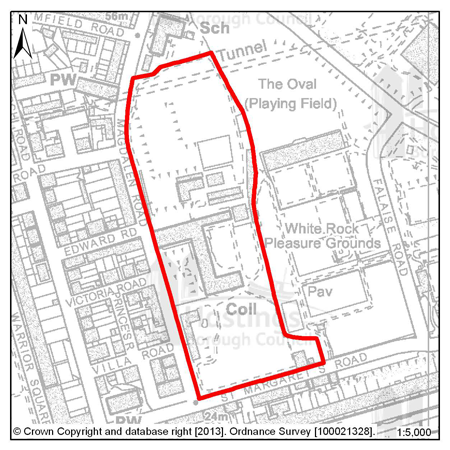
Figure 1: Former Convent of Holy Child Jesus, Magdalen Road
(2) 4.20 The 4.93ha site of the former Convent of Holy Child Jesus, Magdalen Road is a mostly vacant site that is sometimes used as a summer language school. The site includes a number of listed buildings, many of which are in need of repair. Allowing these buildings to become vacant and to deteriorate further represents a wasted resource. The Council wants to see as many as possible of the historically important buildings sympathetically converted and re-used. There may be a number of acceptable uses for the site; the key issue for the Council will be whether a specific proposal will be able to fund the repair and maintenance of the listed buildings.
(1) 4.21 In an established residential area, one option would be for the conversion of the listed buildings to residential use (with the exception of the Grade II* Chapel building, for which see below). Based on current information, the Council considers that the Priory, the Gothic Building, the Gate Lodge and the former Convent Building could be converted so as to provide approximately 32 dwellings.
4.22 Any development of this site will need to secure the restoration and long term future of the historic buildings. This will include the restoration and ongoing maintenance of the Grade II* listed Chapel building which is not capable of being converted but is a nationally important building.
(4) 4.23 As a last resort this could be achieved by means of enabling development. Enabling development is development that would be unacceptable in planning terms but for the fact that it would bring public benefits sufficient to justify it being carried out, and which could not otherwise be achieved. Enabling development is an established and useful planning tool by which a community may, after all other solutions have been explored, be able to secure the long term future of a place of heritage significance, and sometimes other public benefits, provided it is satisfied that the balance of public advantage lies in so doing. The public benefits are funded through the increased value of the land as a result of the grant of planning permission for its development.
(3) 4.24 In this case, because of the national importance of the site (a unique collection of Grade II* and Grade II listed buildings), ‘community’ and ‘public interest’ must be considered in the widest sense. The public gain would be the repair and conservation of the heritage assets for the long term and the amelioration of the harmful impact on the character and appearance of the area that is caused by the buildings’ current poor condition. The dis-benefit would be the approval of built development that would otherwise be unacceptable in planning terms. Permission would only be granted if the public benefits can be shown to outweigh the harm of the scheme.
(2) 4.25 The following therefore, is an enabling development policy (a means of enabling restoration of the significance and setting of the heritage assets), not a specific site allocation for development.
(17) Policy HN6 – Former Convent of Holy Child Jesus, Magdalen Road
The Council will only grant planning permission for development within the curtilage of the Former Convent of Holy Child Jesus which secures the long term future of the existing buildings.
The Council will only approve enabling development where the proposal in question:
- (1) Secures the long term future of all of the listed former Convent buildings including boundary walls and structures of those walls;
- (1) Secures the ongoing management of the whole of the site as a single entity and as a place of special significance;
- (1) Is, subject to the need to provide affordable housing (for which see below), the minimum amount of development required to secure the long term future of the existing buildings and the site as a whole;
- (1) Follows genuine investigation of the potential for securing the long term future of the buildings without the need for enabling development and the exploration of unrestricted disposal on the open market;
- (1) Can be shown to be the only realistic source of sufficient subsidy to secure the long term future of the buildings;
- (1) Minimises the harm to other public interests;
- (1) Provides an appropriate amount of affordable housing (for which see Policy H3 of the Planning Strategy), even if this increases the overall number of units to be provided; and where
- (1) The public benefit of securing the future of the heritage assets through such enabling development decisively outweighs the harm or otherwise caused by the scheme.
In addition, planning permission will only be granted for enabling development if:
- (1) The impact of the development is precisely defined at the outset, through the granting of full, rather than outline, planning permission;
- (1) The achievement of the heritage objective is secured through the use of a Section 106 agreement or other enforceable means;
- (1) The heritage assets concerned are repaired to an agreed standard, or the funds to do so made available, as early as possible in the course of the enabling development, and in any event, before completion or occupation of any new build;
The Planning Authority will closely monitor implementation, if necessary acting promptly to ensure that obligations are fulfilled.
All policies of the Local Plan will be applied, as appropriate, to any scheme presented to the Council.
Relationship to the Planning Strategy (2014)
Policy:
EN1: Built and Historic Environment
Natural Environment
4.26 The basis of the policy framework for protecting the natural environment is contained in the Planning Strategy, the majority of this is detailed in Chapter 7: Protecting our Environment but it also relates to Policy T3: Provision of a Strategic Cycle Network and Policy CI2: Sports and Leisure Facilities. Where further detail is required, which is not included in the Planning Strategy, additional policies are provided here.
The Green Infrastructure Network
4.27 Planning Strategy Policy EN2 provides the framework for recognising and enhancing the green infrastructure network in Hastings, and requires new or enhanced green infrastructure to be incorporated into new development. A green infrastructure network is especially important in an urban area like Hastings to ensure natural areas are safeguarded and enhanced, and connections between these spaces are retained and improved where possible.
4.28 Green infrastructure can be incorporated into development in a wide variety of ways. The nature and scale of green infrastructure will depend on the type of development proposed and the existing character of the site and its surroundings. A range of green infrastructure should be explored in order to determine what is most appropriate for that particular site. A list of green infrastructure “functions” that need to be considered is listed in support of Policy EN2 of the Planning Strategy, although examples include:
- Enhancement and protection of biodiversity
- Providing space for sustainable drainage
- Protecting historic landscapes
- Providing for sustainable transport routes (e.g. cycle network)
- Providing a network of footpaths and rights of way, and strengthened links between designated greenspaces and other open space around the town
(1) 4.29 Site allocations in the Development Management Plan seek to identify specific opportunities for enhancing green infrastructure where possible. Examples include new green space, or reserving land for cycle routes. The type of space needs to be appropriate to the surrounding area, yet offer a suitable variety of environments, fulfilling amenity, recreational, visual and ecological purposes.
4.30 Policy HN7 sets out the Council’s general expectations for the inclusion, protection and enhancement of green infrastructure in development proposals. This policy will apply both to allocated sites and to any other sites which are brought forward during the course of the plan period.
4.31 The Council will require planning applications to include assessments of existing ecology that are completed by a suitably and relevantly qualified professional. These assessments should examine both on-site ecology and the connectivity of the site with the green network, and make provision for improvements where necessary both on and off site. All habitats, including trees, hedges, shrubs and ponds should be identified, together with opportunities for the retention or creation of green infrastructure. The specific species of the proposed new planting should be given careful consideration to avoid ‘invasive species’ and the loss of neighbouring amenity. Measures for protection and management of the ecology will also be required, where appropriate.
Policy HN7 – Green Infrastructure in New Developments
Where appropriate, good quality green infrastructure should be integrated into the design of new developments. Development will normally be permitted where opportunities for green infrastructure and landscaping have been incorporated into the proposals.
New green infrastructure provided as part of a development scheme should create safe links for the community and connectivity for biodiversity should be provided as far as practical, within the existing Green Infrastructure Network.
Relationship to the Planning Strategy (2014)
Policies:
EN2: Green Infrastructure Network
EN3: Nature Conservation and Improvement of Biodiversity T3:
Provision of a Strategic Cycle Network
CI2: Sports and Leisure Facilities
Biodiversity and green space
(1) 4.32 The Borough has numerous designated green spaces, ranging from international, to national, to local importance. Policy HN8 provides additional guidance for the environmental protection policies set out in Chapter 7 and also, Policy CI2 of the Planning Strategy, and Policy HN9 of this Plan. It is particularly important that proposals follow the approach set out in Policy EN3 of the Planning Strategy, in that they contribute positively to the natural environment by:
- Avoiding harm to biodiversity
- Adequately mitigating against unavoidable damage, or
- As a last resort, compensate for any unavoidable damage
4.33 An Ecological Constraints and Opportunities Plan will be required to support relevant planning applications, and this will be specified in the validation checklist for planning applications. These assessments will also need to show a particular understanding of the impact of any potential development site on protected green areas in their locality, not just within the proposed development site. Importantly a scheme presented to the Council must reflect the findings of the Ecological Constraints and Opportunities Plan and appropriate design solutions should be incorporated.
4.34 To view what is required in support of an application that may impact upon environmental resources please see the “validation checklist” available at: http://www.hastings.gov.uk/environment_planning/planning/info_advice/app_forms_guidance_notes/
(3) Policy HN8 – Biodiversity and Green Space
Development should result in no net loss of biodiversity or designated green space as defined on the Policies Map. The weight given to the protection of sites will be proportionate to their position in the hierarchy of internationally, nationally and locally designated sites.
Development that would affect a designated site will only be permitted where there is an adverse impact on ecological, geological or biodiversity interests of the site if it can be demonstrated that;
- The need for the development would outweigh the nature conservation interests;
- Adverse impacts can be satisfactorily minimised through mitigation and compensation measures;
An Ecological Constraints and Opportunities Plan, completed by a suitably and relevantly qualified professional, will be required to support planning applications where on-site or nearby ecological constraints are known, or where further information on potential ecological issues is required. This assessment should include:
- Information of existing on-site ecology
- Opportunities for connectivity between spaces and improved accessibility to them
- Green space and biodiversity improvements on and off-site as appropriate
- Opportunities for the retention or creation of green infrastructure
- Measures for the protection and management of ecology, where appropriate
- An arboriculture assessment
Relationship to the Planning Strategy (2014)
Policies:
EN2: Green Infrastructure Network
EN3: Nature Conservation and Improvement of Biodiversity
EN4: Ancient Woodland
EN5: Local Nature Reserves
EN6: Local Wildlife Sites
EN7: Conservation and Enhancement of Landscape
EN8: Open Spaces – Enhancement, Provision and Protection
Landscape
4.35 Of particular significance to Hastings is the nationally designated High Weald Area of Outstanding Natural Beauty (AONB), which covers 18% of the Borough. The AONB closely follows the Borough’s administrative boundary to the north but to the east takes in the whole of Hastings Country Park and the Hastings Cliff Special Area of Conservation. Hastings Country Park represents the best coastal section of the AONB. The Council recognises the importance of protecting this nationally important landscape, and major development should not take place in the AONB save in exceptional circumstances as outlined at paragraphs 116 of the NPPF5.
4.36 The Combe Haven Valley, in the west of the Borough, which includes the Combe Valley Countryside Park, is also recognised as a distinct landscape character area6, and here too it will be important to protect and enhance the existing landscape character of the area.
4.37 Any development that is proposed in the Combe Valley Countryside Park or High Weald will need to have regard to the potential impact to the landscape character. Development proposals within the AONB need to have regard to the purposes of the AONB designation, and will need to demonstrate how the proposal protects and enhances the landscape in accordance with NPPF policy. A landscape character assessment will be required to support relevant planning applications. Such assessments will also need to show an understanding of the impact of any potential development both within areas of landscape value and in their locality. Importantly a scheme presented to the Council must reflect the findings of the landscape assessment and appropriate design or mitigation measures should be incorporated.
(2) Policy HN9 – Areas of Landscape Value
Areas of landscape value - Area of Outstanding Natural Beauty (AONB) and the Combe Valley Countryside Park, are displayed on the Policies Map. The inherent visual qualities and distinctive character of these areas will be protected. Development will only be permitted that is not detrimental to the character, scenic quality or visual benefit of these areas.
Where development proposals have the potential to impact an area of landscape value a landscape assessment will be required to understand the level of impact. Where impacts are identified proposals should incorporate the recommendations of this assessment
Relationship to the Planning Strategy (2014)
Policies:
EN2: Green Infrastructure Network
EN7: Conservation and Enhancement of Landscape
Amenity green spaces
(2) 4.38 The Policies Map displays the boundaries of all of the protected green spaces in the Borough, both nationally and locally designated. These include Sites of Special Scientific Interest (SSSI), Special Areas of Conservation (SAC), Local Nature Reserves (LNR), Local Wildlife Sites (LWS), Ancient Woodland and more.
4.39 The Development Management Plan provides for the recognition and protection of three further locally identified sub-categories of open or green space – private open space, allotments and local green spaces. Their importance is primarily based on their social, recreational and appearance value, but these also have indirect biodiversity value and can act as a connection between other green spaces. These areas are also identified on the Policies Map.
4.40 There are some areas of green space in the Borough that are valued for their recreational role and the contribution they can make to the townscape of an area. Private open space can create breaks in the street scene and should be protected from development that would prejudice the open nature of such areas. Some local green spaces, such as allotments, are considered important in their local areas and make a valuable contribution to recreation and the areas character.
4.41 Allotments serve a number of purposes: They are a source of healthy food and they provide recreation for urban dwellers and they also support wildlife and biodiversity. There are presently 14 Council owned allotment sites in Hastings and one private site in Vale Road. All but one of the Council sites is directly managed, although the Council does encourage self-management. Waiting lists for allotments vary over time but at the time that the Plan was prepared they were at their lowest for a number of years. This is due in part to the Council creating additional plots through sub-division and bringing back uncultivated land into use. There are no plans to create additional allotment sites. The Council will however seek to retain existing sites in allotment use.
4.42 The Council will protect these areas for the community for their amenity value and also because they contribute to the green infrastructure network.
(52) Policy HN10 – Amenity Green Spaces
The Council will protect Private Open Space, Allotments and Local Green Spaces used and/or managed by the local community, as identified on the Policies Map. Planning permission will only be granted for development which would result in the loss of an identified amenity green space in the following circumstances:
- It can be demonstrated that the land no longer has any visual, recreational, amenity or ecological value; or
- An area of equivalent size and value is provided in the locality in compensation.
Relationship to the Planning Strategy (2014)
Policies:
EN2: Green Infrastructure Network
EN8: Open Spaces – Enhancement, Provision and Protection
Part v) Economic Policies
Shopping areas
5.1 To protect the viability of shopping and other commercial activities and the mix of shops and services on offer, and to balance the aspirations and needs of local communities, the Local Plan provides policy guidance on what land uses will be permitted in the shopping areas defined in the Policies Map.
5.2 Some of the larger shopping areas provide a range of facilities, including not only shops and banks but also GP surgeries and dentists. These help to reduce the need for people in the neighbourhood to make long distance journeys. These centres are focal points in the local neighbourhood and are also accessible to less mobile members of the community, thus aiding social inclusion.
5.3 Shopping areas also are of great importance to the provision of employment opportunities and services. There is potential to add to the number of people using the shops and services in the centres, and, for these reasons, there is a need to protect the land uses in these areas so they remain predominantly in retail and business use.
5.4 The defined shopping areas are listed below (these follow the shopping hierarchy set out in Policy E3 of the Planning Strategy and are in general support of the other policies of Chapter 9):
| Town Centre | Hastings Town Centre |
| District Centre |
St Leonards Centre |
| Local Centre | Bohemia |
| Neighbourhood Centre |
Battle Road |
Street trading and markets
5.5 Other activities that take place in and around the identified shopping areas can help to add to the vitality and vibrancy of them. Markets can be a good way for businesses to develop or for customers to discover new things. They can also help foster community spirit and create an identity for an area. A licence for street trading is required for anyone wishing to run a market stall and this can be obtained, provided that information about the times of sale, the types of things for sale and proof of insurance are submitted to the Council. For more information on this please see the our web pages: http://www.hastings.gov.uk/environment_planning/licensing/licensable_activities_forms/#street_trading
5.6 The Council will continue to encourage and support well managed street markets such as those that have proved successful in Hastings Town Centre, The Stade and Kings Road in St Leonards.
Hastings Town Centre Shopping Area
Non-shopping uses within Hastings Town Centre
5.7 There is a clear desire to ensure that Hastings Town Centre retains and strengthens its retail offer. A strong retail presence is essential if the town centre is to compete effectively with other nearby shopping destinations, including Eastbourne and Royal Tunbridge Wells, and to remain a sub-regional centre within the South East.
5.8 Recent national guidance also suggests that identifying core (or primary) areas of retail and secondary areas of niche shops, cafés and restaurants is important. This can help to maintain the vitality of town centres and the appropriate mix of services on offer within them.
5.9 The retail offer in Hastings Town Centre is characterised by a mix of larger national multiple retailers and smaller independent and specialist retailers. The primary retail core of the town centre, which is identified on the Policies Map, is focused around Priory Meadow. The adjoining pedestrianised streets of Queens Road, Robertson Street, Wellington Place and further to the north along Queens Road as far as the Morrisons food store contain national retailers, large and small shops and other services. There are also important areas of specialist and independent shops on Trinity Street, Claremont and the non-pedestrianised section of Robertson Street extending into White Rock.
5.10 It is recognised that different and complementary uses during the day and in the evening can reinforce each other, making the town centre more attractive to local residents, shoppers, workers and visitors. Helping to maintain and enhance the vibrancy and vitality of Hastings Town Centre will be the continued encouragement of appropriate residential development above premises in the identified areas. These factors have been taken into consideration when setting the threshold levels for non-A1 use classes in the primary retail areas.
5.11 Retail uses should continue to dominate the primary retail core. Policy SA1 will be applied when assessing applications for the change of use from an A1 retail unit to another use.
Priory Meadow
5.12 Priory Meadow is a pedestrianised shopping centre located in the central part of the primary retail core. This is the prime retail location within the shopping area, catering for mainstream comparison shopping and accommodating the majority of the Town’s multiple stores. Pedestrian flows are high and vacancy levels are low indicating the retail supremacy of the area. This area is a primary attraction to shoppers visiting Hastings Town Centre. The retail function should continue to predominate strongly here. There is a planning condition that states that non-A1 uses should not exceed 1,400m2 of the total floorspace of Priory Meadow.
The remaining shopping area
5.13 This part of the primary shopping area is characterised by a mixed retail presence including national multiples, independent traders in smaller units and a number of specialist stores. Again pedestrian flows are high here with excellent linkages to the railway station, bus routes and access to multi-storey car parking at Priory Meadow and Priory Street. The seafront car parks also serve this shopping area. Restricting non-A1 to 45% of the total number of ground floor units would allow scope for a range of uses within this primary retail core area without damaging the current function of the area.
5.14 The following factors will be taken into account in the implementation of Policy SA1:
- The size of retail units
Within the Town Centre, retail units and frontages vary in both size and character. For example, a retail unit with a greater frontage generally has a more significant impact on the street scene. It is therefore appropriate to consider the scale of the unit subject to development.
- The concentration of non-retail units
In general, a number of non-A1units adjacent to each other in the shopping frontage on one side of the road could constitute a high concentration and therefore a significant interruption. However, this would depend also on the scale and location of the units in question and the types of use proposed. For example, a number of class A3 (Restaurants and café) units within the shopping frontage may add character and life to a shopping frontage, where as a class C3 (Dwelling Houses) use would not add to the attractiveness to shoppers of the shopping area. The Council will therefore consider each case on its individual merits, having regard to the existing situation and the use proposed.
5.15 When determining planning applications seeking a change of use away from A1, within Hastings Town Centre Shopping Area, the current percentage position between Planning Use Class A1 and non A1 uses will be calculated ignoring floorspace/units in a temporary flexible use. Only the permanent lawful use of the floorspace/unit will form part of the calculation.
Policy SA1 – Hastings Town Centre Shopping Area
Within Hastings Town Centre Shopping Area, as defined on the Policies Map, at ground floor level, proposals for planning use-class A1, A2, A3, A4 and other uses appropriate to the character of the shopping area will be permitted provided both of the following criteria are satisfied:
- The proposal would not result in non-A1 uses exceeding 5% of the total floorspace of Priory Meadow and not more than 45% of the total number of ground floor units in the remaining shopping area, as defined on the Policies Map;
- The proposal would not result in such a concentration of non class A1 uses as to lead to a significant interruption in the shopping frontage, thus harming the vitality and viability of the town centre shopping area as a whole.
Relationship to the Planning Strategy (2014)
Policy:
E3: Town, District and Local Centres
Other Shopping Areas
District, Local and Neighbourhood Centres
5.16 It is important to assist the smaller centres in the town. They provide convenient district, local and neighbourhood level facilities as well as in some cases, being valuable for specialist services.
5.17 In order to protect the role of these centres within the shopping hierarchy, in line with Planning Strategy Policy E3, the Council will seek to ensure that the key retail areas indicated on the Proposals Map are retained for predominantly class A1 uses (shops). Planning applications for non-A1 uses may be permitted in these areas, but only provided that they would not either individually, or cumulatively with other recently completed developments and outstanding planning permissions, be likely to undermine the primary retail function of these areas. Appropriate residential development above premises within these areas will be welcomed to help maintain and enhance the vibrancy and vitality of them.
5.18 St Leonards serves a broader function than the other district centres. Though smaller, it is similar in character to Hastings Town Centre, and includes a broad range of retailers within the centre, comprising a mix of national multiples, independent traders and specialist traders, along with a number of banks, building societies, restaurants and cafés.
5.19 The Primary retail area of St Leonards includes the whole of King’s Road, the lower part of London Road, and the eastern part of Norman Road. It is important that a vibrant and varied mix of town centre retail uses remain predominant in this area.
5.20 The areas of Silchester Road, the eastern part of Grand Parade, the upper part of London Road (number 45 upwards) and the western part of Norman Road contain varying levels of retail activity, but are interspersed with commercial and residential uses. These areas are therefore considered to be secondary retail areas. Whilst it is still important to ensure that the overall vitality and viability of these areas is not diminished, a greater degree of flexibility will be applied to allowing non-retail uses including banks, building societies (class A2), cafes and restaurants (class A3), pubs and bars (class A4) and small commercial office space (class B1(a) office).
5.21 The main speciality centre in the Borough is the Old Town with its craft and antique shops and restaurants.
5.22 Silverhill and Ore are the other two district centres. They rely on a good range of local convenience stores and, in particular, the presence of supermarkets. Both centres have a Post Office, high street banks and building societies, and a range of professional services. At Silverhill, the core shopping area has now been extended and reinforced by the opening of a large scale supermarket.
5.23 Bohemia local centre comprises primarily independent retailers but with a limited number of national retailers. There is a range of professional services including estate agents and solicitors.
5.24 Neighbourhood Shopping Areas, as indicated on the Policies Map, cater primarily for the day to day needs of the nearby area or those passing by, but may also cater for more limited specialist needs from a wider area. They are more easily accessible to the local community, in particular the elderly and less mobile. The role of Local and Neighbourhood Shopping Areas has been somewhat eroded in recent times with the increased preference for large food stores and increased car use, but the Council intends to do what it can to support the survival of these important community assets.
5.25 The neighbourhood shopping areas at West St Leonards (Bexhill Road), Battle Road, Mount Pleasant, Mount Road and Marine Court include a more limited range of stores, for example newsagents/confectioners, chemist, post office, grocers/mini-market, baker and butcher, serving their immediate neighbourhoods. These centres range in size and character from the small groups of shops at Mount Pleasant to the more specialist shops at Marine Court.
5.26 When determining planning applications seeking a change of use away from A1, within a defined shopping area, the current percentage position between Planning Use Class A1 and non - A1 uses will be calculated ignoring units in a temporary flexible use. Only the permanent lawful use of the unit will form part of the calculation.
5.27 The following factors will be taken account in the implementation of Policy SA2:
- The size of retail units
Retail units and retail frontages vary in both size and character. For example, a retail unit with a greater frontage generally has a more significant impact on the street scene. It is therefore appropriate to consider the scale of the unit subject to development.
- The concentration of non-retail units
In general, a number of non-A1 units adjacent to each other in the shopping frontage on one side of the road could constitute a high concentration and therefore a significant interruption. However, this would depend also on the scale and location of the units in question and the types of use proposed. For example, a number of class A3 (Restaurants and café) units may add character and life to a retail frontage, whereas, a class C3 (Dwelling Houses), use would not add to the attractiveness of the shopping area. The Council will therefore consider each case on its individual merits, having regard to the existing situation and the use proposed.
Policy SA2 – Other Shopping Areas
Within district, local and neighbourhood Primary Shopping Areas, as defined on the Policies Map, at ground floor level, proposals for Class A1, A2, A3, A4, A5 and other uses appropriate to the character of the shopping area will be permitted provided both of the following criteria are satisfied:
- The proposal would not result in non-A1 uses exceeding the stated proportion for each of these shopping areas, as defined on the Policies Map:
| St Leonards Centre |
Primary area 40% Secondary area 60% |
| The Old Town | 45% |
| Ore Village | 45% |
| Silverhill | 45% |
| Bohemia | 50% |
| Battle Road | 50% |
| Mount Pleasant | 40% |
| Mount Road | 40% |
| Marine Court | 40% |
| West St Leonards (Bexhill Road) | 40% |
- The proposal would not result in the excessive concentration of non-A1 uses which would cause a significant interruption in the shopping frontage, reducing its attractiveness and thus harming the vitality and viability of the centre as a whole.
Relationship to the Planning Strategy (2014)
Policy:
E3: Town, District and Local Centres
Shops and services outside defined shopping areas
5.28 Some local shops and services provide a particularly important focal point for a community. The corner shop or doctors surgery that is outside of the main shopping areas, as shown on the Policies Maps, is potentially more accessible, especially for those without private transport, and the Council believes that these should be afforded some protection.
5.29 Policy SC1 of the Planning Strategy details how a sustainable community could be achieved and an important part of this is access to shops and services. This access is for existing services or for goods that are required on a daily basis and can most often be found in local convenience shops.
5.30 Policy SA3 is intended for those shops and services that generally have a small catchment area and whose customers and visitors are less likely to arrive by car.
5.31 It is, however, acknowledged that where it can be demonstrated that the shop or service is not economically viable (this will be determined on a case by case basis), and has been tested through marketing, it may be unreasonable to refuse a change of use.
Policy SA3 – Shops and Services outside the Shopping Areas
Proposals for the change of use or redevelopment that would result in the loss of a local shop or service outside the defined commercial areas will only be permitted when:
- There is an alternative within reasonable walking distance; or
- It is demonstrated that the existing use is no longer viable.
Relationship to the Planning Strategy (2014)
Policies:
SC1: Overall Strategy for Managing Change in a Sustainable
Way
E3: Town, District and Local Centres
Drinking establishments and hot food take-aways
5.32 There may be a need to manage the concentration of shops and services outside defined shopping areas, and also the concentration of single types of outlet to reduce, for example, noise or litter production. Policy DM3 of this plan details what should be considered, in terms of amenity, by proposers of schemes. In the cases of proposals for drinking establishments (A4 in the Planning Use Class Order) and hot food take-aways (use class A5), the Council believes some extra assessment of the likely impacts will be required. The nature of these assessments and additional information are outlined in Policy SA4.
5.33 Certain types of retail activity have a greater effect on their neighbours; this could be because of what they sell or the hours that they open. The particular nature of alcohol and (hot food) take-away sales means that people use the premises that sell them in a different way to other shops and restaurants.
5.34 Proposals that involve drinking establishments and (hot food) take-aways should include careful consideration of the ways that people are going to use the premises. This will include how they will access the premises, whether there is enough parking, and at what times customers are likely to use them. All of these will affect both immediate neighbours and those living in the local vicinity, and should be carefully assessed.
Policy SA4 – Drinking Establishments and Hot Food Take-Aways
Planning permission for new drinking establishments (use class A4 of the Town and Country Planning Use Classes Order 1987 (as amended)) and hot food take-aways (use class A5) will be granted provided that:
- The precise nature of the use proposed (which should be specified in the planning application), including opening hours, is given;
- The proposal would not adversely affect neighbours, for example, causing excess noise or smell;
- The proposal would not, on its own, or cumulatively with other such uses in the area, be likely to result in problems of disturbance or public disorder;
- Suitable off-street parking is or can be provided where there is insufficient on-street parking; and
- It would not cause inconvenience or danger on the public highway as a result of the additional stopping and manoeuvring of vehicles.
Relationship to the Planning Strategy (2014)
Policies:
SC1: Overall Strategy for Managing Change in a Sustainable
Way
E3: Town, District and Local Centres
Caravan, camping and chalet sites
5.35 Caravan and camping sites contribute in an important way to tourism. Planning Strategy Policy E4 demonstrates the Council’s commitment to secure sustainable tourism development in the town. As most of the towns existing caravan and camping pitches adjoin the High Weald Area of Outstanding Natural Beauty and other significant environmental designations, it is important any proposals for expansion are sensitive to the impact on the countryside, particularly in terms of preserving and enhancing the landscape and avoiding any adverse impact.
5.36 The Local Plan does not include a specific policy criterion requiring the use of caravan, camping and chalets sites on a seasonal basis only. However, assurance that the premises shall not be occupied as a person’s sole or main place of residence will be dealt with by condition of the planning permission.
(2) Policy CC1 – Caravan, Camping and Chalet sites
Planning permission will be granted for additional caravan and camping sites or the expansion of existing sites provided the proposal:
- would not, either on its own or cumulatively in combination with other established or proposed sites in the vicinity, have an adverse impact on accessible greenspaces, harm the landscape character or rural amenity of the countryside and the resident population, and an assessment of potential ecological and landscape impact is provided;
- is conveniently and well located in relation to an adequate road system which can accommodate the traffic generated;
- where possible, has convenient access to footpaths and cycle routes and frequent public transport services;
- gives consideration to the provision of a proportion of pitches to be reserved for touring caravans or campers.
Proposals for the intensification (increase in pitch number within the existing permitted area), the reorganisation of uses/layout (within the existing site) and the enhancement of site facilities/provision of new facilities in connection with existing sites for tents, touring caravans, static caravans and chalets will be permitted provided the proposal:
- would not, either on its own or cumulatively with the remainder of the site or in combination with other established or proposed sites in the vicinity, harm the landscape character or rural amenity of the countryside and resident population;
- is conveniently and well-located in relation to an adequate road system which can accommodate the traffic generated;
- where possible, has convenient access to frequent public transport services;
- includes landscape improvements relevant to the development and a scheme for their maintenance;
- would not significantly reduce the range and choice of available accommodation as a result of a loss of tent and/or touring caravan pitches.
Relationship to the Planning Strategy (2014)
Policies:
EN3: Nature Conservation and Improvement of Biodiversity
EN7: Conservation and Enhancement of Landscape
E4: Tourism and Visitors
Cultural Quarters
5.37 The policy which follows is derived directly from objectives set out in the Hastings Cultural Regeneration Strategy 2010-2015 and also confirmed in the Hastings Planning Strategy.
5.38 It is widely recognised that cultural activities can make a vital contribution to a local economy including the creative sector, increasing employment and skill levels and empowering residents and communities. By supporting cultural activity, we can strengthen our visitor economy and raise aspirations in the Town. In addition, the NPPF recognises the importance of the cultural well-being of the community in planning for sustainable development.
(1) 5.39 Hastings has a strong and diverse cultural infrastructure including a number of important components - most recently, the Jerwood Gallery and Stade performance space but also: performance venues; museums; art galleries and studios; the cultural dimension offered by Sussex Coast College and the University of Brighton Hastings campus; the Creative Media Centre; the potential that could come from the restoration of Hastings Pier and most importantly, its artists, performers and other creative businesses and communities and its tradition of festivals.
5.40 Cultural activities include: visual and performing arts, media, architecture and design, heritage and historic environment, libraries and literature, museums and galleries, education and cultural related tourism. However, a range of other activities are associated with them and provide necessary support, for example: hospitality, specialist retail, food and drink, workshops, and community led activities.
5.41 It is natural for many of these to cluster within an area for mutual advantage. Such areas are often characterised by mixed uses, diversity, and small scale activities such as workshops, live-work premises and café culture. They need to embrace flexibility, change and temporary uses to engender an environment which is creative and vital in nature. They can also benefit if there is an availability of indoor and outdoor exhibition and performance space. Supporting and nurturing such areas is important if they are to thrive.
5.42 In Hastings, four such areas have been identified and planning policy will seek to support their role and a secure future for them. The areas are:
5.43 Old Town and The Stade – The Old Town has long been the focus for a wide range of cultural activity helped by its distinctive non-conformist image – ranging from Old Town Week, to crafts, to performance art. The introduction of the Jerwood Gallery and The Stade performance space linked to the strong heritage of the fishermen’s beach and museum is a new facet for the area. The St Mary in the Castle area is also included.
5.44 White Rock and the America Ground – The cluster of the theatre, the hotel, the pier and the opportunities of the White Rock Baths site and Bottle Alley defines the western end of this area which extends eastwards along the seafront to the America Ground area with the library, the Creative Media Centre and its collection of restaurants and cafés.
(1) 5.45 Academic – The core of this area is Sussex Coast College and the two University of Brighton’s Hastings campus buildings and the cultural activity generated within them. Complementary activities such as shops and cafés are beginning to establish and could be encouraged further.
5.46 Central St Leonards and The Seafront – A range of cultural activities are spread throughout this centre, including art and craft shops, small galleries and community facilities including the Magnet Centre. St Leonards Gardens and Warrior Square are used for performance and cultural events, and there are small sites suitable for cultural projects. The area has been the subject of a regeneration programme over a number of years and it is becoming a favoured place for artists to locate to.
5.47 To support this policy, where opportunities arise and subject to available resources, the Council will take steps to enhance positive qualities of the built environment and the public realm within the Cultural Quarters.
(3) Policy CQ1 – Cultural Quarters
The Council recognises the importance of cultural activities within Hastings, to the local economy and the well-being and enjoyment of the community at large and to visitors.
Four Cultural Quarters have been identified where such activities are concentrated, and where their continuance and expansion will be encouraged and supported:
- Old Town and The Stade Cultural Quarter
- White Rock and the America Ground Cultural Quarter
- Academic Cultural Quarter
- Central St Leonards Cultural Quarter
The areas displayed on the next pages, are indicative of where the identified activities take place and should be seen as a guide and not necessarily a boundary.
Within these areas:
- Development will be encouraged which will assist the further expansion of their role as centres for cultural and related leisure and business activities.
- Proposals will be viewed in terms of their contribution to the mix and diversity of uses and to their potential to enhance their attraction to visitors.
- The Council will also take into account the effect of any development proposals on existing cultural activities and expect them to be protected or for there to be no net loss.
- To improve vitality, a positive approach will be taken to assist the occupation of under-used floors above shops and other premises.
The Council will exercise this planning policy in a way that does not compromise its adopted Licensing Policy. The Licensing Policy is designed to guide the licensing of the sale of alcohol, clubs and regulated entertainment.
Relationship to the Planning Strategy (2014)
Policies:
FA3: Strategy for Hastings Town Centre
FA4: Strategy for Central St Leonards
Cultural Quarter 1: Old Town and The Stade Cultural Quarter
Figure 2: Old Town and The Stade Cultural Quarter
Cultural Quarter 2: White Rock and the America Ground Cultural Quarter
Figure 3: White Rock and the America Ground Cultural Quarter
Cultural Quarter 3: Academic Cultural Quarter
Figure 4: Academic Cultural Quarter
Cultural Quarter 4: Central St Leonards Cultural Quarter
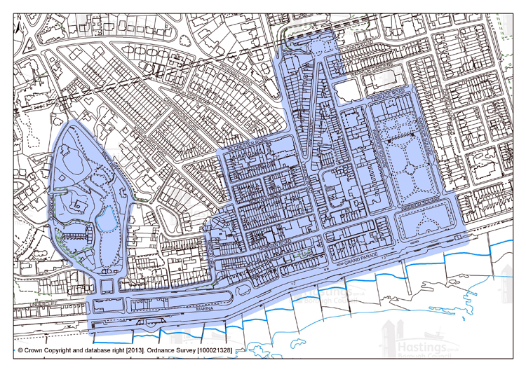
Figure 5: Central St Leonards Cultural Quarter
2 Under the Town and Country Planning (General Permitted Development) Order as amended 3 Use Classes of the Town and Country Planning Use Classes Order 1987 (as amended) 4 For more information see: http://www.hastings.gov.uk/environment_planning/planning/info_advice/pre_app_advice/#listed 5 https://www.gov.uk/government/uploads/system/uploads/attachment_data/file/6077/2116950.pdf 6 As set out in the East Sussex County Council’s Landscape Character Assessment available at: http://www.eastsussex.gov.uk/environment/landscape/download.htm