
Development Management Plan Revised Proposed Submission Version March 2014
Section Five – Appendices
Appendix A: Site Design Briefs
Design Briefs for sites in Focus Area 1
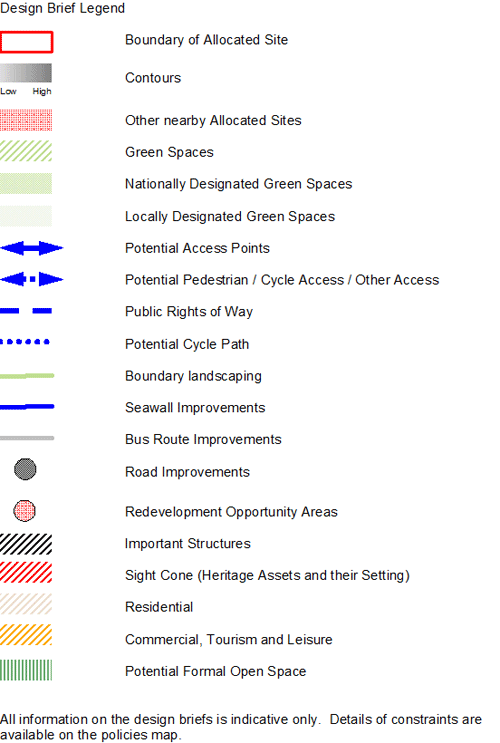
LRA1: Holmhurst St Mary, LRA2: Harrow Lane Playing Fields and LRA3: Land adjacent to 777 The Ridge
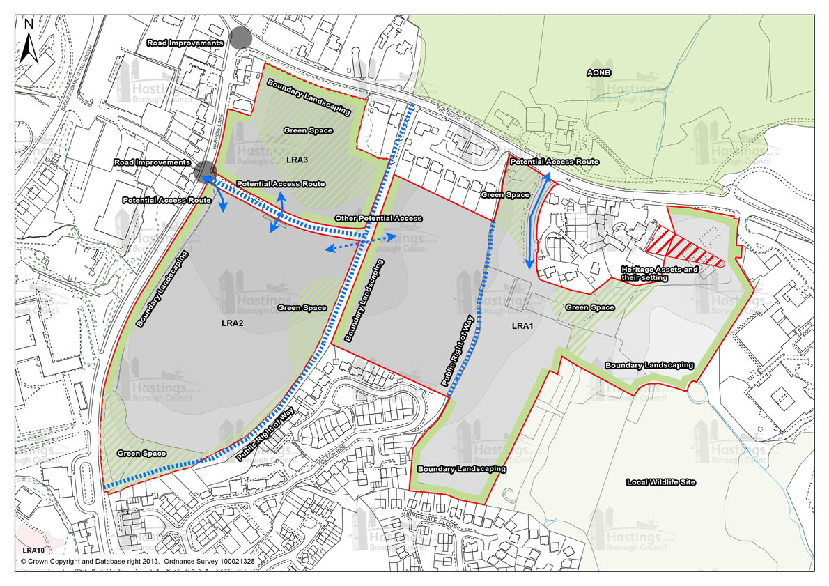
Figure 98 - Design Brief for sites LRA1, LRA2 and LRA3
LRA6: Queensway North, Queensway
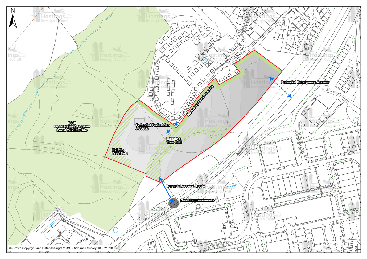
Figure 99 - Design Brief for LRA6
LRA7: Land at junction of The Ridge West & Queensway and LRA8: Land in Whitworth Road, The Ridge West

Figure 100 - Design Brief for sites LRA7 and LRA8
Design Briefs for sites in Focus Area 2
(1) GH1: Robsack A, Church Wood Drive
Figure 101 - Design Brief for GH1
GH2: Mayfield E, Bodiam Drive
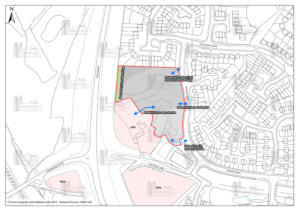
Figure 102 - Design Brief for GH2
GH8: Sites PX and QX Churchfields GH9: Site NX2, Sidney Little Road, GH10: Site RX2, Sidney Little Road and GH11: Site NX3, Sidney Little Road, Churchfields
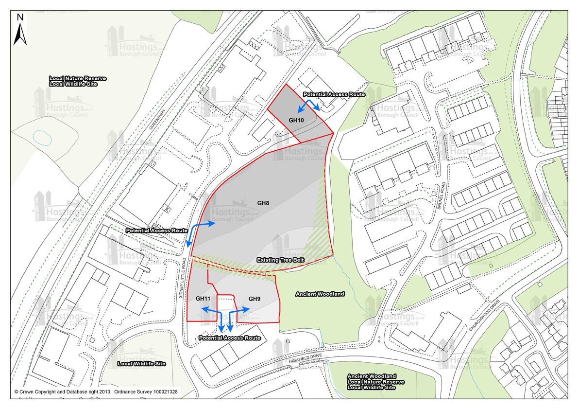
Figure 103 - Design Brief for sites GH8, GH9, GH10 and GH11
Design Briefs for sites in Focus Area 3
(1) FB1: The Grove School
Figure 104 - Design Brief for FB1
FB2: Former West St Leonards Primary School
Figure 105 - Design Brief for FB2
FB3: Seaside Road, West St Leonards and FB6: Cinque Ports Way (Former Stamco Timber Yard & TA Centre)
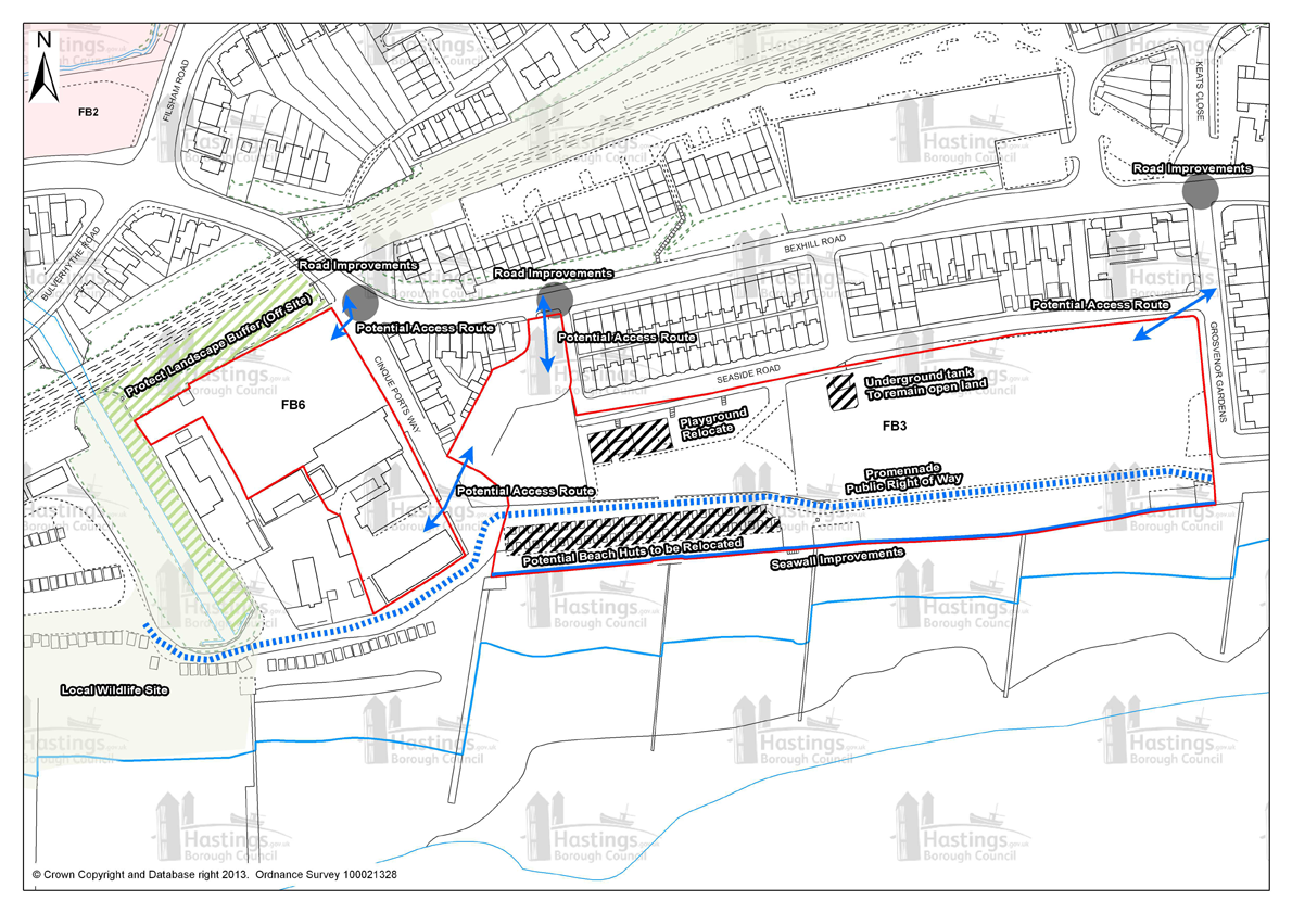
Figure 106 - Design Brief for sites FB3 and FB6
FB4: Former Westerleigh School

Figure 107 - Design Brief for FB4
Design Briefs for sites in Focus Area 4
SH1: Land adjacent to Sandrock Park, The Ridge and SH3: Hurst Court, The Ridge
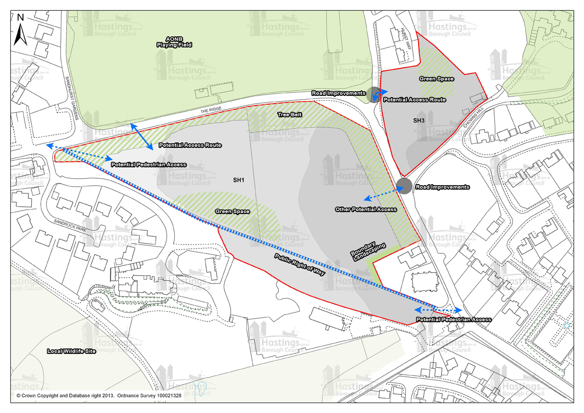
Figure 108 - Design Brief for sites SH1 and SH3
SH4: Mount Denys, Pinehill & Ridgeway
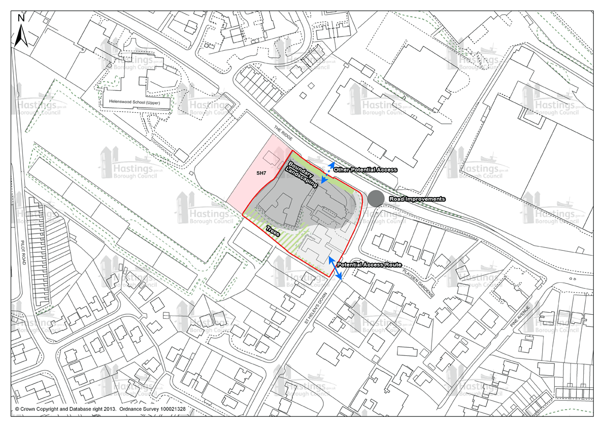
Figure 109 - Design Brief for SH4
Design Briefs for sites in Focus Area 5
SAP2: Hollingsworth Garage, Braybrooke Road

Figure 110 - Design Brief for SAP2
SAP3: 12-19 Braybrooke Terrace
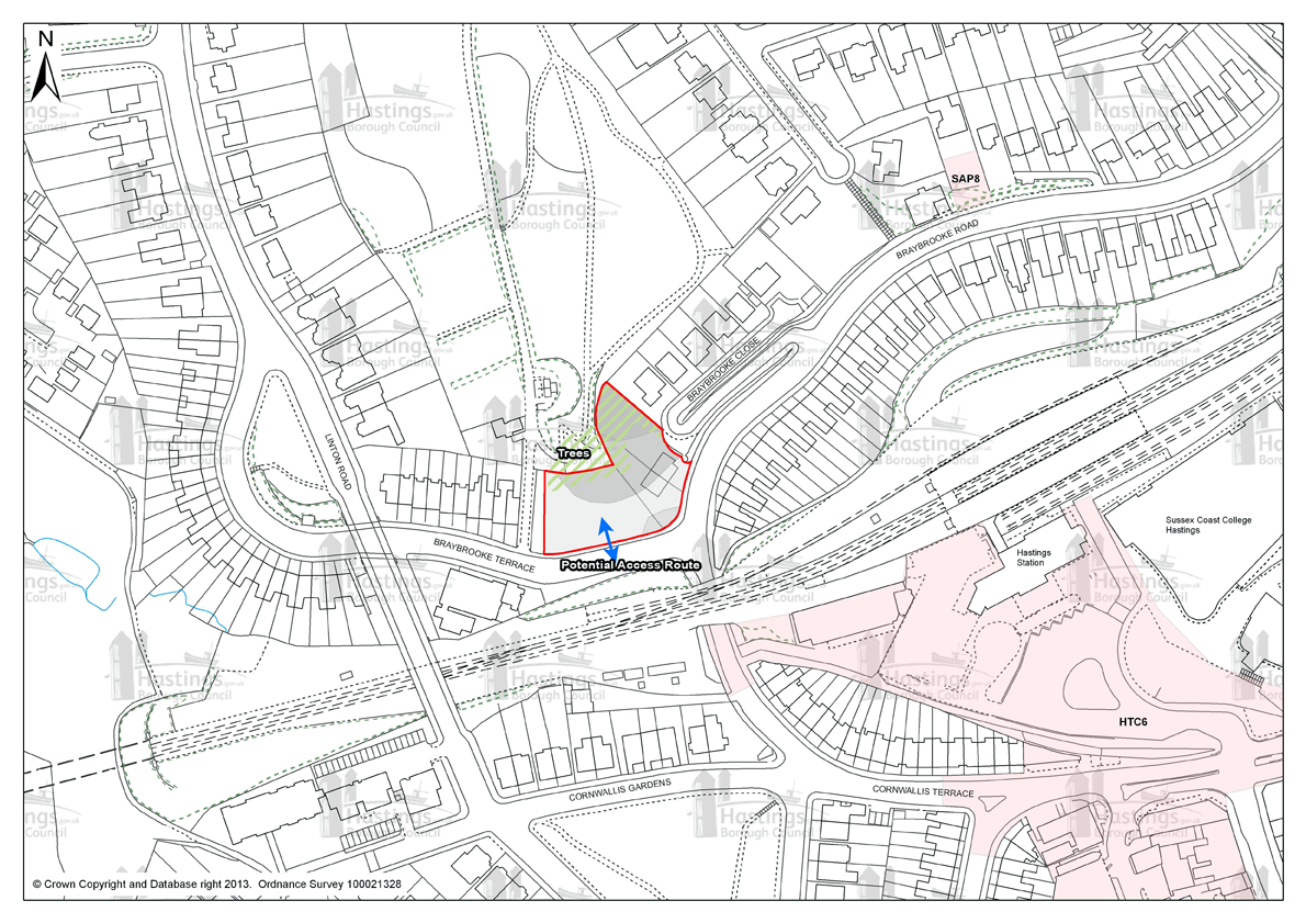
Figure 111 - Design Brief for SAP3
Design Briefs for sites in Focus Area 6
MBL3: Gambier House, West Hill Road
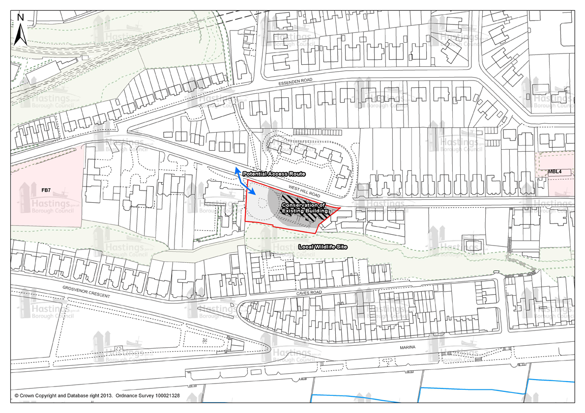
Figure 112 - Design Brief for MBL3
Design Briefs for sites in Focus Area 7
(1) CLB2: Taxi Office/B.R. Social Club, St Johns Road
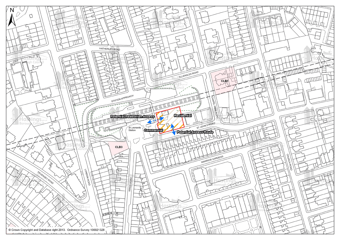
Figure 113 - Design Brief for CLB2
Design Briefs for sites in Focus Area 8
HTC6: Priory Quarter, Havelock Road
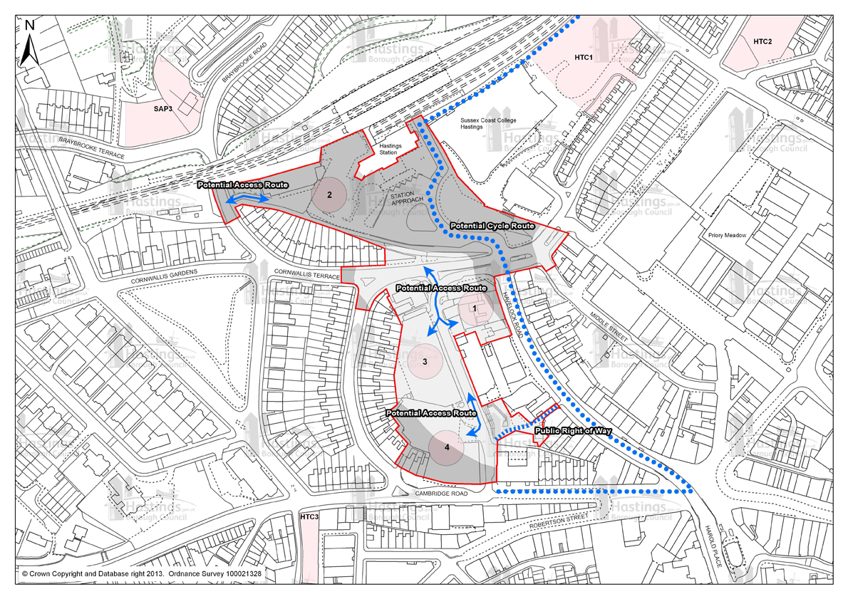
Figure 114 - Design Brief for HTC6
Design Briefs for sites in Focus Area 11
HOV1: Former Stills Factory, Ore Valley and HOV2: Ore Valley
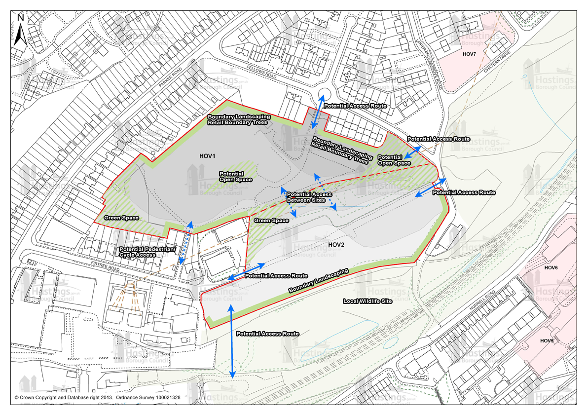
Figure 115 - Design Brief for sites HOV1 and HOV2
HOV3: Former Mount Pleasant Hospital, Frederick Road
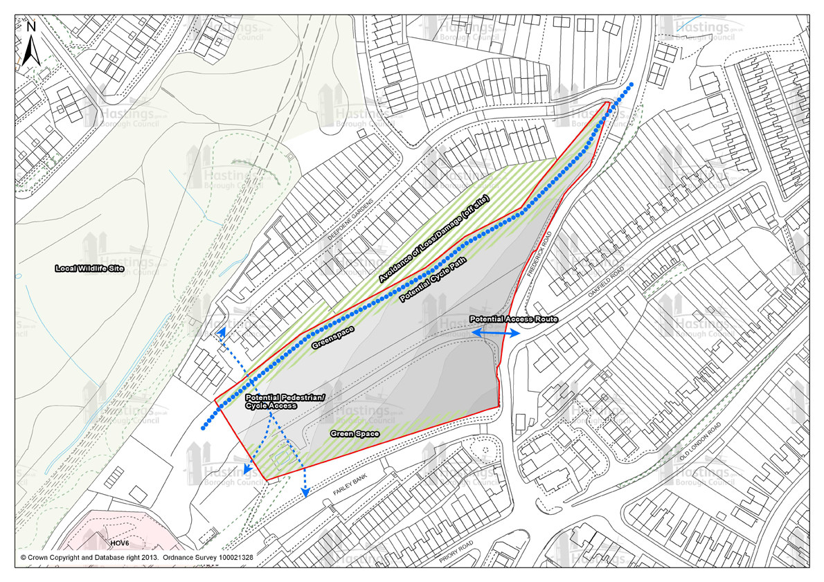
Figure 116 - Design Brief for HOV3
HOV11: Ivyhouse Lane, Northern Extension
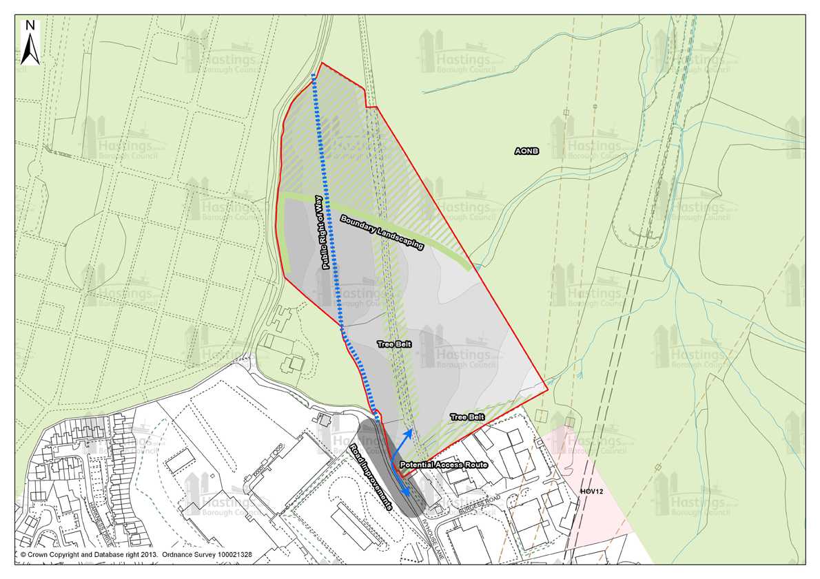
Figure 117 - Design Brief for HOV11
Design Briefs for sites in Focus Area 12
CVO3: Rear of Old London Road and CVO4: Church Street
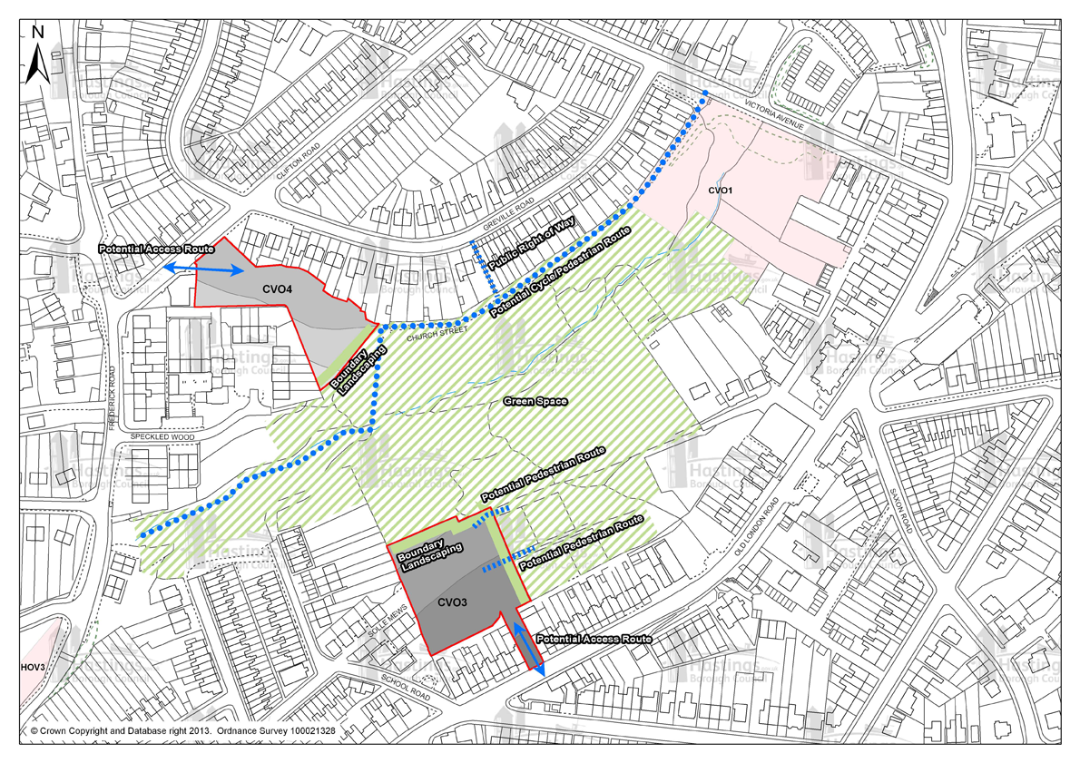
Figure 118 - Design Brief for sites CV03 and CVO4
Appendix B - Superseded Policies
|
Local Plan 2004 page number |
Local Plan 2004 Chapter |
Local Plan 2004 Policy Reference |
Local Plan 2004 Policy name |
How the Policy will be superseded |
|---|---|---|---|---|
|
29 |
Employment |
E1 |
Sites for Employment Development – Allocates sites at Broomgrove, west of Queensway and Ivyhouse Lane specifically for employment use. |
Planning Strategy – DS2 (Employment Growth) and E1( Existing Employment Land and Premises) Development Management Plan – site allocations: LRA 6 (QueenswayNorth); HOV11 (IvyhouseLane, Northern Extension) |
|
31 |
Employment |
E3 |
Ivyhouse Lane – Land at Burgess Road – Site specific policy to enable road connection to Hayward Way |
Development Management Plan – Site Allocation: HOV12 (Land East of Burgess Road, Ivyhouse) |
|
32 |
Employment |
E4 |
Retaining Employment Uses - Safeguards development of existing employment land from non B1 uses |
Planning Strategy – E1 (Existing Employment Land and Premises) and E2(SkillsandAccess to Jobs) Development Management Plan – DM1 (Design Principles), DM3 (General Amenity) and DM4 (General Access) |
|
32 |
Employment |
E5 |
Relocation of Non- ConformingUses – Provides exception to E4 by accepting relocation of business uses that are detrimentaltosurrounding area |
Planning Strategy – E1 (Existing Employment Land and Premises) Development Management Plan – DM1 (Design Principles), DM3 (General Amenity) and DM4 (General Access) |
|
33 |
Employment |
E6 |
Small Industrial Firms – Criteria based policy allowing small firms in the built up area |
Development Management Plan – DM1 (Design Principles), DM3 (General Amenity) and DM4 (General Access) |
|
34 |
Employment |
E7 |
ClassB1(a)Office Development – Defines broad locations suitable for B1(a) use |
Planning Strategy – DS2 – (Employment Growth) Development Management Plan – DM1 (Design Principles), DM3 (General Amenity) and DM4 (General Access) |
|
34 |
Employment |
E8 |
LocationofBusinessUses – Provides criteria for regulating new business development in residential areas |
Development Management Plan – DM1 (Design Principles), DM3 (General Amenity) and DM4 (General Access) |
|
35 |
Employment |
E9 |
Locating Employment Sustainably – Criteria based policy to ensure employment development minimises traffic, has appropriate parkinglevels,improves public transport access and makes provision for cycling |
Planning Strategy – SC1 (Overall Strategy for Managing Change in a Sustainable Way) Development Management Plan – DM1 (Design Principles), DM3 (General Amenity) and DM4 (General Access) |
|
Local Plan 2004 page number |
Local Plan 2004 Chapter |
Local Plan 2004 Policy Reference |
Local Plan 2004 Policy name |
How the Policy will be superseded |
|---|---|---|---|---|
|
41 |
Tourism |
T1 |
New Tourist Attractions – Criteria based policy regulating approvalof planning permissions for new tourist attractions |
Planning Strategy – E4 (Tourism and Visitors) Development Management Plan – DM1 (Design Principles), DM3 (General Amenity) and DM4 (General Access) and HN10 (Amenity Green Spaces) |
|
41 |
Tourism |
T2 |
Amusements – Designates areas suitable for amusements |
Planning Strategy – E4 (Tourism and Visitors) Development Management Plan – DM1 (Design Principles), DM3 (General Amenity) and DM4 (General Access); HN1 (Development affecting the significance and setting of designated heritage assets (including Conservation Areas) and CQ1 (Cultural Quarters) |
|
42 |
Tourism |
T6 |
Caravan and Camping Sites – Criteria based policy to control the growth and expansion of existing sites |
Planning Strategy – E4 (Tourism and Visitors) Development Management Plan – CC1 (Caravan and Camping Sites) |
|
44 |
Tourism |
T7 |
Development within Caravan and Camping Sites Criteria based policy for the enhancement of facilities at existing sites |
Planning Strategy – E4 (Tourism and Visitors) Development Management Plan - CC1 (Caravan and Camping Sites) |
|
Local Plan 2004 page number |
Local Plan 2004 Chapter |
Local Plan 2004 Policy Reference |
Local Plan 2004 Policy name |
How the Policy will be superseded |
|---|---|---|---|---|
|
53 |
Shopping |
S1 |
Town Centre Retail Proposals – Allocates areas specifically for retail use in the town centre |
Planning Strategy – E3 (Town, District and Local Centres) Development Management Plan – SA1 (Hastings Town Centre Shopping Area) |
|
54 |
Shopping |
S2 |
District and Local Centres – Protects key retail frontages identified on Policies Map for predominantly A1 uses |
Planning Strategy – E3 (Town, District and Local Centres) Development Management Plan – SA2 (Other Shopping Areas) |
|
55 |
Shopping |
S3 |
Bohemia Road Core Shopping Area – Aims to retain ground floor of properties in defined core shopping area on Policies Map for A1-A3 uses |
Planning Strategy – E3 (Town, District and Local Centres) Development Management Plan – SA2 (Other Shopping Areas) |
|
Local Plan 2004 page number |
Local Plan 2004 Chapter |
Local Plan 2004 Policy Reference |
Local Plan 2004 Policy name |
How the Policy will be superseded |
|---|---|---|---|---|
|
69 |
Transport |
TR5 |
Cycling Facilities in New Developments – Requires developers to provide cycle facilities in accordance with adopted standards |
Planning Strategy – T3 (Sustainable Transport) Development Management Plan – DM4 (General Access) |
|
69 |
Transport |
TR6 |
Location of New Development – Requires retail, industrial, commercial and community development to be located close to public transport, and/ or to be accessible by walking and cycling. |
Planning Strategy – SC1 (Overall Strategy for Managing Change in a Sustainable Way); T3 (Sustainable Transport) and T4 (Travel Plans) Development Management Plan – DM4 (General Access) |
|
70 |
Transport |
TR7 |
Accessibility – Requires all major new development to make provision for pedestrians, cyclists and public transport and provide mitigation where necessary |
Planning Strategy – SC1 (Overall Strategy for Managing Change in a Sustainable Way); T3 (Sustainable Transport) and T4 (Travel Plans) Development Management Plan – DM4 (General Access) |
|
70 |
Transport |
TR8 |
Reduced Parking Provision in New Development – Sets out that reduced parking standards will be applied in areas where public transport, pedestrian and cycling accessibility is good |
Planning Strategy –T3 (Sustainable Transport) and T4 (Travel Plans) Development Management Plan – DM4 (General Access) East Sussex County Council SPD |
|
71 |
Transport |
TR10 |
Development in un-metalled Streets – Refuses developments that will generate additional traffic in streets that do not have adequately metalled carriageways |
Development Management Plan - DM4 (General Access) |
|
Local Plan 2004 page number |
Local Plan 2004 Chapter |
Local Plan 2004 Policy Reference |
Local Plan 2004 Policy name |
How the Policy will be superseded |
|---|---|---|---|---|
|
82 |
Housing |
H1 |
Housing Sites – Lists all sites allocated for housing in the period up to 2011 |
Planning Strategy – DS1 (New Housing Development) and FA1, FA2, FA3, FA4, FA5, FA6 – The focus area policies set out the principles for the spread of new housing sites and the numbers of new dwellings in each area Development Management Plan – All Site Allocations |
|
85 |
Housing |
H2 |
Mixed Use Areas – Allocates areas suitable for mixed-use developments. |
Planning Strategy –FA1, FA2, FA3, FA4, FA5, FA6 – The focus area policies set out the principles for the spread of new housing sites and the numbers of new dwellings in each area. Development Management Plan – Site Allocations. |
|
87 |
Housing |
H4 |
Housing Conversions – Criteria based policy to control conversions to flats, safeguarding unnecessary conversions of family dwellings |
Development Management Plan - DM1 (Design Principles), DM3 (General Amenity) and HC1 (Conversion of Existing Dwellings) |
|
89 |
Housing |
H6 |
Social Rented Housing – Provides for a proportion of social rented housing in all suitable residential developments of 15 or more dwellings (or .5ha), a minimum of 25% social housing will be sought. And identifies allocated housing sites (H1) as being suitable for an element of social rented housing |
Planning Strategy – H3 (Provision of Affordable Housing) Development Management Plan – Site Allocations (all to include housing or commuted sum in accordance with H3 of the Planning Strategy) |
|
Local Plan 2004 page number |
Local Plan 2004 Chapter |
Local Plan 2004 Policy Reference |
Local Plan 2004 Policy name |
How the Policy will be superseded |
|---|---|---|---|---|
|
99 |
Community Needs |
CN1 |
Access for People with Disabilities – Requires new development to provide adequate access and facilities for people with restricted mobility and/or other disabilities |
Development Management Plan – DM4 (General Access) |
|
103 |
Community Needs |
CN7 |
Premises for Early Years Education – Criteria based policy to control potential impacts of premises used for early years education. Requires premises to be accessible to public transport, walking and cycling |
Development Management Plan – DM1 (Design principles), DM3 (General Amenity ) and DM4 (General Access) |
|
105 |
Community Needs |
CN9 |
Nursing Homes, Rest Homes and Hostels – Criteria based policy to control potential impacts of extensions, change of use or new premises. |
Development Management Plan – DM1 (Design principles), DM3 (General Amenity ) and DM4 (General Access) and HC2 (Residential Institutions and Student Halls of Residence) |
|
Local Plan 2004 page number |
Local Plan 2004 Chapter |
Local Plan 2004 Policy Reference |
Local Plan 2004 Policy name |
How the Policy will be superseded |
|---|---|---|---|---|
|
113 |
Nature Conservation |
NC1 |
Hastings Cliffs Special Area of Conservation - Provides for the protection of this internationally important site. Development proposals likely to have a significant effect will be subject to rigorous assessment. Exceptions to policy must meet the policy criteria |
Planning Strategy – EN3 (Nature Conservation and Improvement of Biodiversity) Development Management Plan – HN8 (Biodiversity and Green Space) |
|
114 |
Nature Conservation |
NC2 |
Sites of Special Scientific Interest - Provides for the retention and protection of Sites of Special Scientific Interest only allowing development subject to meeting policy criteria and providing adequate mitigation |
Planning Strategy – EN3 (Nature Conservation and Improvement of Biodiversity) Development Management Plan – HN8 (Biodiversity and Green Space) |
|
116 |
Nature Conservation |
NC3 |
Local Nature Reserves - Provides for the retention and protection of Local Nature Reserves (designated and proposed) only allowing development subject to meeting policy criteria and providing adequate mitigation |
Planning Strategy – EN3 (Nature Conservation and Improvement of Biodiversity) and EN5 (Local Nature Reserves) Development Management Plan – HN8 (Biodiversity and Green Space) |
|
117 |
Nature Conservation |
NC5 |
Local Nature Reserve Allocations - Allocates land at 5 locations as Local Nature Reserves |
Planning Strategy – EN3 (Nature Conservation and Improvement of Biodiversity) and EN5 (Local Nature Reserves) Development Management Plan – HN8 (Biodiversity and Green Space) |
|
119 |
Nature Conservation |
NC6 |
Sites of Nature Conservation Importance - Provides for the protection of Sites of Nature Conservation Importance subject to demonstrating a local need outweighing the nature conservation interest of the site, and the provision of adequate mitigation |
Planning Strategy – EN3 (Nature Conservation and Improvement of Biodiversity) and EN6 (Local Wildlife Sites) Development Management Plan – HN8 (Biodiversity and Green Space |
|
120 |
Nature Conservation |
NC7 |
The Green Network – Seeks to protect the Green Network from development that would sever, intrude or otherwise cause harm to its nature or purpose |
Planning Strategy – EN2 (Green Infrastructure Network) Development Management Plan – HN7 (Green Infrastructure in New Developments); HN8 (Biodiversity and Green Space); HN9 (Areas of Landscape Value) and HN10 (Amenity Green Spaces) |
|
122 |
Nature Conservation |
NC8 |
General Planning Requirements – Seeks to ensure that development minimises damage to wildlife and habitats, ensuringlosses are minimised and adequately compensated for. Also seeks to ensure well-planned development that contributes towards a net gain in biodiversity and opportunities to enhance the local environment from both a nature conservation and amenity perspective. |
Development Management Plan – HN8 (Biodiversity and Green Space ) |
|
124 |
Nature Conservation |
NC9 |
Information to Accompany Planning Applications – Seeks to ensure that developers provide sufficient ecological assessment of a site in support of a planning application |
Development Management Plan – HN8 (Biodiversity and Green Space) |
|
125 |
Nature Conservation |
NC10 |
Ancient Woodland - Provides for the protection of ancient woodland through planning conditions or legal agreement |
Planning Strategy – EN3 (Nature Conservation and Improvement of Biodiversity) and EN4 (Ancient Woodland) Development Management Plan – HN8 (Biodiversity and Green Space) |
|
125 |
Nature Conservation |
NC11 |
Preserved Woodland - Provides for the protection of preserved woodland of more than 0.4ha in area within 20m of the development |
Planning Strategy – EN3 (Nature Conservation and Improvement of Biodiversity) Development Management Plan – HN8 (Biodiversity and Green Space) |
|
126 |
Nature Conservation |
NC12 |
St Helens Wood – Protection |
Planning Strategy – EN3 (Nature Conservation and Improvement of Biodiversity) Development Management Plan – HN8 (Biodiversity and Green Space) |
|
Local Plan 2004 page number |
Local Plan 2004 Chapter |
Local Plan 2004 Policy Reference |
Local Plan 2004 Policy name |
How the Policy will be superseded |
|---|---|---|---|---|
|
129 |
Landscape |
L1 |
Landscape Character - Seeks to prevent development that would substantially compromise the landscape setting of the town |
Planning Strategy – EN7 (Conservation and Enhancement of Landscape) Development Management Plan – HN9 (Areas of Landscape Value) |
|
130 |
Landscape |
L2 |
High Weald Area of Outstanding Natural Beauty - Seeks to resist development which would have an adverse impact on the Area of Outstanding Natural Beauty. Major development will not be permitted unless it can be demonstrated to be in the public interest |
Planning Strategy – EN7 (Conservation and Enhancement of Landscape Development Management Plan – HN9 (Areas of Landscape Value) |
|
131 |
Landscape |
L3 |
Development Outside the Built-Up Area – Seeks to
prevent development outside of the defined built-up
area. |
Planning Strategy – EN3 (Nature Conservation and Improvement of Biodiversity) and EN7 (Conservation and Enhancement of Landscape) Development Management Plan – DM1 (Design Principles), and HN8 (Biodiversity and Green Space) |
|
133 |
Landscape |
L6 |
Historic Parks and Gardens - The Policy seeks to prevent development that would harm the historic significance, character, appearance and setting of identified historic parks and gardens |
Planning Strategy – EN1 (Built and HistoricEnvironment) Development Management Plan – HN8 (Biodiversity and Green Space) |
|
Local Plan 2004 page number |
Local Plan 2004 Chapter |
Local Plan 2004 Policy Reference |
Local Plan 2004 Policy name |
How the Policy will be superseded |
|---|---|---|---|---|
|
138 |
Development Guidelines |
DG1 |
Development Form – General design criteria applicable to all new development. |
Planning Strategy – SC1, SC2, SC3, SC4 and SC7 – the sustainable community policies set out the principles for development guidance Development Management Plan – DM1 (Design Principles) |
|
139 |
Development Guidelines |
DG2 |
Access and Parking – Criteria based policy requiring all new development to satisfactorily meet the access needs of all users and balanced transport provision. |
Planning Strategy – SC1 (Overall Strategy for Managing Change in a Sustainable Way) and SC2 (Design and Access Statements) Development Management Plan – DM4 (General Access) |
|
139 |
Development Guidelines |
DG3 |
Sunlight and Daylight Requires adequate natural light within new buildings and prevents the unacceptable loss of natural light or outlook to neighbouring properties arising from development. |
Planning Strategy – SC1(Overall Strategy for Managing Change in a Sustainable Way), SC2 (Design and Access Statements) and SC3 (Promoting Sustainable and Green Design) Development Management Plan – DM1 (Design principles), DM3 (General Amenity) |
|
140 |
Development Guidelines |
DG4 |
Noisy Activities –Seeksto prevent development likely to result in unacceptable levels of noise and measures to attenuate noise levels. |
Planning Strategy – SC1 (Overall Strategy for Managing Change in a Sustainable Way) Development Management Plan – DM6 (Pollution and Hazards) |
|
140 |
Development Guidelines |
DG5 |
NoiseSensitiveDevelopment – Seeks to prevent the provision of housing, hospitals, schools, nursing homes and other ‘noise sensitive development’, in areas which are or are likely to be subject to unacceptably high levels of noise unless satisfactory attenuation measures can be achieved. |
Planning Strategy – SC1 (Overall Strategy for Managing Change in a Sustainable Way) and SC2 (Design and Access Statements) Development Management Plan – DM6 (Pollution and Hazards) |
|
141 |
Development Guidelines |
DG6 |
External Lighting – Criteria based policy seeking to ensure that external lighting schemes are well designed, appropriate to the surroundings and do not cause a hazard for road users. |
Planning Strategy – SC1(Overall Strategy for Managing Change in a Sustainable Way) Development Management Plan – DM6 (Pollution and Hazards) |
|
141 |
Development Guidelines |
DG7 |
High or Visually Prominent Buildings – Criteria based policy seeking to ensure that development maintains or enhances the surrounding area, has regard to Conservation Areas or areas of landscape importance and does not result in unacceptable overshadowing of neighbouring properties. |
Planning Strategy – SC1(Overall Strategy for Managing Change in a Sustainable Way) Development Management Plan – DM1 (Design principles), DM3 (General Amenity) |
|
142 |
Development Guidelines |
DG8 |
Protection of Views Criteria based policy – providing for the protection of public views. |
Planning Strategy – SC1 (Overall Strategy for Managing Change in a Sustainable Way) Development Management Plan – DM1 (Design Principles), DM3 (General Amenity) and HN9 (Areas of Landscape Value) |
|
143 |
Development Guidelines |
DG9 |
Traffic Calming – Provides for the need to provide traffic calming measures within new development. |
Planning Strategy – SC1(Overall Strategy for Managing Change in a Sustainable Way) and SC2 (Design and Access Statements Development Management Plan – DM4 (General Access) |
|
144 |
Development Guidelines |
DG11 |
Gardens – Requires private amenity space within dwellings intended for family use. |
Planning Strategy – SC1(Overall Strategy for Managing Change in a Sustainable Way) Development Management Plan – DM3 (General Amenity) |
|
145 |
Development Guidelines |
DG12 |
Two Storey Side Extensions to Residential Properties – Criteria based policy aimed to prevent the unacceptable impact of two-storey side extensions in terms of design and their impact on the street scene. |
Planning Strategy – SC1 (Overall Strategy for Managing Change in a Sustainable Way) and SC2 (Design and Access Statements) Development Management Plan – DM1 (Design Principles), DM3 (General Amenity) |
|
146 |
Development Guidelines |
DG14 |
Shopfronts – Criteria based policy providing for new Shopfronts or alterations to existing Shopfronts. |
Planning Strategy – SC1 (Overall Strategy for Managing Change in a Sustainable Way) Development Management Plan – DM1 (Design Principles), HN1 (Development affecting the Significance and Setting of Designated Heritage Assets, including Conservation Areas) HN2 (Changing Doors Windows and Roofs in Conservation Areas) and the related SPD |
|
147 |
Development Guidelines |
DG15 |
Security Shutters – Criteria based policy ensuring acceptable design and preventing their unnecessary use. |
Planning Strategy – SC1 (Overall Strategy for Managing Change in a Sustainable Way) Development Management Plan – DM1 (Design Principles) and HN1 (Development affecting the Significance and Setting of Designated Heritage Assets, including Conservation Areas) |
|
148 |
Development Guidelines |
DG16 |
Outdoor Advertisements and Signs – Criteria based policy seeking to ensure they are not detrimental to the appearance of building(s) affected and/or the surrounding area, or a danger to the public highway. |
Planning Strategy – SC1 (Overall Strategy for Managing Change in a Sustainable Way) Development Management Plan – DM1 (Design Principles) and DM3 (General Amenity) and HN1 (Development affecting the Significance and Setting of Designated Heritage Assets, including Conservation Areas) |
|
148 |
Development Guidelines |
DG17 |
Licensed Premises – Relates to the location of large drinking establishments and seeks to prevent new uses that are out of character with the area, or the over concentration of A3 uses in town, district or local centres. |
Development Management Plan – DM3 (General Amenity); SA1 (Hastings Town Centre Shopping Area); SA2 (Other Shopping Areas ) and SA4 (Managing the Amenity of Services Outside the Shopping Areas) |
|
149 |
Development Guidelines |
DG18 |
Hot Food Take-Away – Provides for hot food takeaway subject to criteria based policy. |
Development Management Plan – DM3 (General Amenity) DM4 (General Access); SA1 (Hastings Town Centre Shopping Area); SA2 (Other Shopping Areas ) and SA4 (Managing the Amenity of Services Outside the Shopping Areas) |
|
149 |
Development Guidelines |
DG19 |
Commercial Development – Traffic – Seeks to ensure that traffic generation from commercial development affecting residential areas is attenuated by legal agreements and/or planning conditions. |
Development Management Plan – DM3 (General Amenity) DM4 (General Access) and SA4 (Managing the Amenity of Services Outside the Shopping Areas) |
|
150 |
Development Guidelines |
DG20 |
Public Art – Requires the provision of public art in major development schemes. |
Planning Strategy – SC1 (Overall Strategy for Managing Change in a Sustainable Way Development Management Plan – DM3 (General Amenity) |
|
151 |
Development Guidelines |
DG21 |
Development on Unstable Land – On land potentially subject to instability, planning permission will only be granted subject to convincing supporting evidence from the applicant that actual/ potential instability can be overcome. |
Planning Strategy – SC1 (Overall Strategy for Managing Change in a Sustainable Way) Development Management Plan – DM5 (Ground Conditions) |
|
151 |
Development Guidelines |
DG22 |
Satellite Dishes – Provides for satellite dishes to domestic premises where planning permission is required and seeks to prevent insensitive positioning of dishes or similar areas |
Development Management Plan – DM1 (Design Principles) |
|
160 |
Development Guidelines |
DG28 |
Telecommunications Installations – Criteria based policy providing for the prior approval of the siting and appearance of masts and the full planning permission required for larger antennae. |
Planning Strategy – SC1 (Overall Strategy for Managing Change in a Sustainable Way) Development Management Plan – DM2 (Telecommunications Technology) |
|
160 |
Development Guidelines |
DG29 |
High Pressure Gas Main – No new building will be permitted within 14m of the existing high pressure gas main which extends from the junction of Battle Rd & The Ridge West to Watergates Wood. |
Planning Strategy – SC1 (Overall Strategy for Managing Change in a Sustainable Way) Development Management Plan –DM6 (Pollution and Hazards) |
|
161 |
Development Guidelines |
DG30 |
Overhead Power Lines – A 132kV pylon line runs through the Marline Valley, and any new development will be expected to take account of the electricity supplier’s requirements from a safety standpoint. |
Planning Strategy – SC1 (Overall Strategy for Managing Change in a Sustainable Way) Development Management Plan – DM6 (Pollution and Hazards) |
|
161 |
Development Guidelines |
DG31 |
New Overhead Power Lines – In visually sensitive locations, seeks to require – where planning permission is required, or encourage where permission is not required lines, being placed underground. |
Planning Strategy – SC1 (Overall Strategy for Managing Change in a Sustainable Way Development Management Plan – DM6 (Pollution and Hazards) |
|
162 |
Development Guidelines |
DG33 |
Environmental Pollution – Seeks to prevent development which is likely to cause unacceptable pollution of air, water or land. |
Planning Strategy – SC1 (Overall Strategy for Managing Change in a Sustainable Way) Development Management Plan – DM4 (General Access) and DM6 (Pollution and Hazards) |
|
163 |
Development Guidelines |
DG34 |
Contaminated Land – Requires the developer to carry out site investigations of potential hazards and propose the necessary remedial measures required. |
Planning Strategy – SC1 (Overall Strategy for Managing Change in a Sustainable Way) Development Management Plan – DM5 (Ground Conditions) |
|
Local Plan 2004 page number |
Local Plan 2004 Chapter |
Local Plan 2004 Policy Reference |
Local Plan 2004 Policy name |
How the Policy will be superseded |
|---|---|---|---|---|
|
171 |
Historic Environment |
C1 |
Development within Conservation Areas – Criteria based policy providing for development within Conservation Areas seeking to ensure that proposals have due regard to the character and appearance of the area. |
Planning Strategy – EN1 (Built and Historic Environment) Development Management Plan - HN1 (Development affecting the Significance and Setting of Designated Heritage Assets, including Conservation Areas) |
|
173 |
Historic Environment |
C2 |
Demolition in Conservation Areas – Criteria based policy providing for the demolition of unlisted buildings subject to the prior approval of the re-use of the site |
Planning Strategy – EN1 (Built and Historic Environment) Development Management Plan - HN3 (Demolition involving Heritage Assets) |
|
174 |
Historic Environment |
C3 |
Development Involving Listed Buildings – Criteria based policy providing for the extension or alteration of a listed building. |
Planning Strategy – EN1 (Built and Historic Environment) Development Management Plan - HN1 (Development affecting the Significant and Setting of Designated Heritage Assets, including Conservation Areas) |
|
175 |
Historic Environment |
C4 |
Demolition of Listed Buildings – Criteria based policy providing for development that would follow the demolition of a Listed Building |
Planning Strategy – EN1 (Built and Historic Environment) Development Management Plan - HN3 (Demolition involving Heritage Assets) |
|
175 |
Historic Environment |
C5 |
Winch Huts – Provides for new winch huts designed to have a traditional appearance suited to their function. |
Planning Strategy – EN1 (Built and Historic Environment) Development Management Plan - HN1 (Development affecting the Significance and Setting of Designated Heritage Assets, including Conservation Areas) |
|
176 |
Historic Environment |
C6 |
Archaeological Sites and Ancient Monuments – Policy resists development that would adversely affect an archaeological site or ancient monument, or other nationally important archaeological site or monument |
Planning Strategy – EN1 (Built and Historic Environment) Development Management Plan – HN1 (Development Affecting the Significance and Setting of Designated Heritage Assets, including Conservation Areas) and HN4 (Developments Affecting Heritage Assets with Archaeological and Historic Interest or Potential Interest) |
|
177 |
Historic Environment |
C7 |
Replacement Doors and Windows in Listed Buildings – Within Listed Buildings, provides only for exact replicas or doors and windows of an appropriate design and materials. |
Planning Strategy – EN1 (Built and Historic Environment) Development Management Plan - HN1 (Development affecting the Significance and Setting of Designated Heritage Assets, including Conservation Areas and HN2 (Changing Doors, Windows and Roofs in Conservation Areas) and the relatedSPD |
|
177 |
Historic Environment |
C8 |
Replacement Doors and Windows in Conservation Areas – Within Conservation Areas, provides for exact replicas or doors and windows of an appropriate design and materials. Exceptions to policy are subject to meeting one of three criteria. |
Planning Strategy – EN1 (Built and Historic Environment) HN2 (Changing Doors, Windows and Roofs in Conservation Areas) and the related SPD |
|
178 |
Historic Environment |
C9 |
Roof Materials for Listed Buildings – Provides for replacement roofs only where the covering is an exact replica or is of appropriate material. |
Planning Strategy – EN1 (Built and Historic Environment) Development Management Plan – HN2 (Changing Doors, Windows and Roofs in Conservation Areas) and the relatedSPD |
|
178 |
Historic Environment |
C10 |
Roof Materials for Conservation Areas – Provides for replacement roofs only where the covering is an exact replica or is of appropriate material. |
Planning Strategy – EN1 (Built and Historic Environment) Development Management Plan - HN2 (Changing Doors, Windows and Roofs in Conservation Areas) and the relatedSPD |
|
Local Plan 2004 page number |
Local Plan 2004 Chapter |
Local Plan 2004 Policy Reference |
Local Plan 2004 Policy name |
How the Policy will be superseded |
|---|---|---|---|---|
|
186 |
Sports and Recreation |
SP1 |
Playing Fields and Sports Pitches – The Policy seeks to prevent the loss of playing fields and sports pitches unless the proposal meets 1 of 4 criteria |
Planning Strategy – EN8 (Open Spaces; Enhancement, Provision and Protection) CI2 (Sports and Leisure Facilities) and CI3 (Children’s Play Provision) Development Management Plan – HN8 (Biodiversity and Green Space). |
|
186 |
Sports and Recreation |
SP2 |
Sports and Recreational Facilities – Criteria based policy providing for formal sports or recreation uses |
Planning Strategy – EN8 (Open Spaces; Enhancement, Provision and Protection); CI2 (Sports and Leisure Facilities and CI3 (Children’s Play Provision) Development Management Plan – HN8 (Biodiversity and Green Space) |
|
187 |
Sports and Recreation |
SP3 |
Location of Major New Sports and Recreational Facilities ‘Sequential test’ policy relating to the location of major sports and recreation facilities. |
Planning Strategy – EN8 (Open Spaces; Enhancement, Provision and Protection; CI2 (Sports and Leisure Facilities) and CI3 – (Children’s Play Provision) Development Management Plan – DM1 (Design Principles), DM3 (General Amenity), and DM4 (General Access) |
|
187 |
Sports and Recreation |
SP4 |
White Rock Area – Criteria based policy providing for proposals which enhance the range and quality of sports, play and similar leisure provision within White Rock area west of Falaise Road. |
Planning Strategy – EN8 (Open Spaces; Enhancement, Provision and Protection); CI2 (Sports and Leisure Facilities) and CI3 (Children’s Play Provision) Development Management Plan – DM1 (Design Principles), DM3 (General Amenity), and DM4 (General Access) |
|
Local Plan 2004 page number |
Local Plan 2004 Chapter |
Local Plan 2004 Policy Reference |
Local Plan 2004 Policy name |
How the Policy will be superseded |
|---|---|---|---|---|
|
193 |
Open Space |
OS1 |
Protection of Open Space – The policy seeks to protect identified Open Spaces from development which would lead to a loss of their open character. |
Planning Strategy – EN8 (Open Spaces; Enhancement, Provision and Protection); CI2 (Sports and Leisure Facilities) and CI3 (Children’s Play Provision) Development Management Plan – HN8 (Biodiversity and Green Space) |
|
194 |
Open Space |
OS2 |
Areas Deficient in Open Space – The policy seeks to retain open spaces and undeveloped land in those areas of the Borough deemed to be deficient in open space. In appropriate cases a legal agreement will be sought to provide Open Space within new developments. |
Planning Strategy – EN8 (Open Spaces; Enhancement, Provision and Protection) Development Management Plan –HN7 (Green Infrastructure in New Developments), and HN8 (Biodiversity and Green Space) |
|
194 |
Open Space |
OS3 |
Private Open Space – The policy seeks to resist the substantial loss of identified private Open Space |
Planning Strategy – EN8 (Open Spaces; Enhancement, Provision and Protection) Development Management Plan - HN10 (Amenity Green Spaces) |
|
195 |
Open Space |
OS4 |
Allotments – The policy seeks to prevent the development of allotments shown on the Policies Map. |
Planning Strategy – EN8 (Open Spaces; Enhancement, Provision and Protection) Development Management Plan – HN10 (Amenity Green Spaces) |
|
195 |
Open Space |
OS5 |
Amenity Footpath Network – The Policy seeks to safe guard existing or proposed footpaths from new development. Or where development is allowed, ensure that the diverted route is no less attractive, safe and convenient. |
Planning Strategy – EN8 (Open Spaces; Enhancement, Provision and Protection) Development Management Plan - HN7 (Green Infrastructure in New Developments) |
|
Local Plan 2004 page number |
Local Plan 2004 Chapter |
Local Plan 2004 Policy Reference |
Local Plan 2004 Policy name |
How the Policy will be superseded |
|---|---|---|---|---|
|
200 |
Hastings Town Centre |
TC1 |
Hastings Station Yard – The Policy allocates land at this location for a mixed use scheme likely to include educational, business, residential and retail uses. |
Planning Strategy – FA3 (Strategy for Hastings Town Centre) Development Management Plan – Site Allocation HTC1 (Hastings Station Yard (part)) |
|
201 |
Hastings Town Centre |
TC3 |
Queens Road Conversions – Provides for the conversion of properties between 94-168 Queens Road from retail to residential or other suitable uses. |
Planning Strategy – FA3 (Strategy for Hastings Town Centre) Development Management Plan – DM1 (Design Principles), DM3 (General Amenity) and DM4 (General Access) |
|
202 |
Hastings Town Centre |
TC5 |
The Observer Building – Allocates the building within the Town Centre Conservation Area for a mix of uses including higher & further education, residential, offices and ‘live-work’ units. |
Planning Strategy – FA3 (Strategy for Hastings Town Centre) Development Management Plan – Site Allocation HTC3 (The Observer Building) |
|
204 |
Hastings Town Centre |
TC7 |
Greenway – Resists any development that does not ensure its implementation as an integral part of the overall design and route of the Greenway scheme. |
Planning Strategy – FA3 (Strategy for Hastings Town Centre) and EN2 (Green Infrastructure Network) Development Management Plan – HN7 (Green Infrastructure in New Developments) |
|
Local Plan 2004 page number |
Local Plan 2004 Chapter |
Local Plan 2004 Policy Reference |
Local Plan 2004 Policy name |
How the Policy will be superseded |
|---|---|---|---|---|
|
205 |
Central St Leonards |
TC8 |
Memorial Replacement – Safeguards the location shown on the Policies Map, for a replacement to the original Memorial. |
Planning Strategy – FA3 (Strategy for Hastings Town Centre) Development Management Plan – DM1 (Design Principles) and DM3 (General Amenity) |
|
211 |
Central St Leonards |
SL1 |
Taxi Office/BR Social Club Site – Allocates the site for a mixed use development with compatible commercial uses |
Planning Strategy – FA4 (Strategic Policy for Central St Leonards) Development Management Plan – Site Allocation CLB2 (Taxi Office/B.R. Social Club, St Johns Road) |
|
212 |
Central St Leonards |
SL2 |
Problem Buildings – Provides for a flexible approach in the future use of key problem buildings in Central St Leonards if this assists in securing their future viability. |
Planning Strategy – FA4 (Strategy for Central St Leonards) Development Management Plan – DM1 (Design Principles) and DM3 (General Amenity) |
|
212 |
Central St Leonards |
SL3 |
Western Road/Cross Street Area – Provides for development and refurbishment of the area, primarily for housing but other uses may be approved providing they are compatible with the housing and assist the viability of central St Leonards. |
Planning Strategy – FA4 (Strategy for Central St Leonards) Development Management Plan – DM1 (Design Principles) and DM3 (General Amenity) and DM4 (General Access) |
|
Local Plan 2004 page number |
Local Plan 2004 Chapter |
Local Plan 2004 Policy Reference |
Local Plan 2004 Policy name |
How the Policy will be superseded |
|---|---|---|---|---|
|
224 |
West St Leonards |
WSL1 |
Land at Seaside Road – Developments – Allocates the site for mixed use development based on water and beach related commercial tourism and leisure facilities. together with associated services, recreational activities, including a public slipway and housing. |
Planning Strategy – FA1 (Strategic Policy for Western Area) Development Management Plan – Site Allocation FB3 (Seaside Road, West St Leonards) |
|
226 |
West St Leonards |
WSL3 |
Land at Bexhill Road – Development Allocates the site for housing, a replacement community centre and open space. The development must include adequate measures for flood protection and the safeguarding of the SNCI. |
Planning Strategy – FA1 (Strategic Policy for Western Area) Development Management Plan – Site Allocation FB2 (West St Leonards Primary School) |
|
Local Plan 2004 page number |
Local Plan 2004 Chapter |
Local Plan 2004 Policy Reference |
Local Plan 2004 Policy name |
How the Policy will be superseded |
|---|---|---|---|---|
|
235 |
Broomgrove |
B5 |
Broomgrove – Highway Improvements/ Traffic Management – Provides for highway improvements and traffic management measures that will be required if the mixed use development at Broomgrove is to be permitted. |
Planning Strategy – FA5 (Strategic Policy for Eastern Area) Development Management Plan – DM1 (Design Principles) and DM3 (General Amenity) and DM4 (General Access) |
|
235 |
Broomgrove |
B6 |
The Former Stills Factory Site, Fellows Road – Allocates the site for mixed use to include housing and local employment uses (Class B1) subject to the requirements of Policy B5(e). |
Planning Strategy – FA5 (Strategic Policy for Eastern Area) Development Management Plan – Site Allocation HOV1 (Former Stills Factory, Ore Valley) |
|
Local Plan 2004 page number |
Local Plan 2004 Chapter |
Local Plan 2004 Policy Reference |
Local Plan 2004 Policy name |
How the Policy will be superseded |
|---|---|---|---|---|
|
240 |
Holmhurst St Mary |
HSM1 |
Holmhurst St Mary – Development Allocates this greenfield site for housing including the provision of open space, to be released in the latter part of the Plan period subject to monitoring. |
Planning Strategy – FA1 (Strategic Policy for Western Area) Development Management Plan – Site Allocation LRA1 (Holmhurst St Mary) |
|
242 |
Holmhurst St Mary |
HSM2 |
Holmhurst St Mary – Highway Access Provides for access improvements required if the housing development (Policy HSM1) is to be permitted. |
Planning Strategy – FA1 (Strategic Policy for the Western Area) Development Management Plan – Site Allocation LRA1 (Holmhurst St Mary) |
|
Local Plan 2004 page number |
Local Plan 2004 Chapter |
Local Plan 2004 Policy Reference |
Local Plan 2004 Policy name |
How the Policy will be superseded |
|---|---|---|---|---|
|
246 |
Seafront Strategy |
SS1 |
The Stade Maritime Heritage Area – Criteria based policy providing for the development of tourist facilities at this location. |
Planning Strategy – FA6 (Strategic Policy for the Seafront) Development Management Plan – DM1 (Design Principles) and DM3 (General Amenity) and DM4 (General Access) and CQ1 (Cultural Quarters) |
|
247 |
Seafront Strategy |
SS2 |
The Stade/Old Town Seafront – Seeks to ensure that any new development within this area respects the open aspect and accessibility of the area and the strong visual and historic link with the Old Town. |
Planning Strategy – FA6 (Strategic Policy for the Seafront) Development Management Plan – DM1 (Design Principles) and DM3 (General Amenity) and DM4 (General Access), HN1 (Development affecting the Significance and Setting of Designated Heritage Assets, including Conservation Areas); HN2 (Changing Doors, Windows and Roofs in Conservation Areas); HN3 (Demolition involving Heritage Assets); HN4 (Development Affecting Heritage assets with Archaeological and Historic Interest or Potential Interest); HN5 Non Designated Heritage Assets) and CQ1 (Cultural Quarters) |
Table 16: Superseded Policies
Appendix C - Indices of policies
Planning Strategy – Index of Policies
Objectives (NB: The objectives are not policies but are here for reference)
Objective 1: Achieve and sustain a thriving
economy
Objective 2: Ensure everyone has the
opportunity to live in a decent home, which they can afford,
in a community in which they want to live
Objective 3: Safeguard and improve the
town’s environment
Objective 4: Addressing the impacts of
climate change Objective 5: Supporting sustainable
communities
Objective 6: Provision of an efficient and
effective transport system
Objective 7: Making best use of the Seafront
and promoting tourism
The Development Strategy
POLICY DS1: New Housing Development
POLICY DS2: Employment Growth
POLICY DS3: Location of Retail Development
Spatial Areas
POLICY FA1: Strategic Policy for Western
Area
POLICY FA2: Strategic Policy for Central
Area
POLICY FA3: Strategy for Hastings Town
Centre
POLICY FA4: Strategy for Central St
Leonards
POLICY FA5: Strategic Policy for Eastern
Area
POLICY FA6: Strategic Policy for The
Seafront
Theme Based Policies
Sustainable Communities
POLICY SC1: Overall Strategy for Managing
Change in a Sustainable Way
POLICY SC2: Design and Access Statements
POLICY SC3: Promoting Sustainable and Green
Design
POLICY SC4: Working Towards ZeroCarbon
Development
POLICY SC5: District Heating Networks and
Combined Heat and Power Systems
POLICY SC6: Renewable Energy
Developments
POLICY SC7: Flood Risk
Protecting our Environment
POLICY EN1: Built and Historic
Environment
POLICY EN2: Green Infrastructure Network
POLICY EN3: Nature Conservation and
Improvement of Biodiversity
POLICY EN4: Ancient Woodland
POLICY EN5: Local Nature Reserves
POLICY EN6: Local Wildlife Sites
POLICY EN7: Conservation and Enhancement of
Landscape
POLICY EN8: Open Spaces – Enhancement,
Provision and Protection
Housing
POLICY H1: Housing Density
POLICY H2: Housing Mix
POLICY H3: Provision of Affordable
Housing
POLICY H4: Houses in Multiple Occupation
POLICY H5: Accommodation for Travelling
Communities
The Local Economy
POLICY E1: Existing Employment Land and
Premises
POLICY E2: Skills and Access to Jobs
POLICY E3: Town, District and Local
Centres
POLICY E4: Tourism and Visitors
Community Infrastructure
POLICY CI1: Infrastructure and Development
Contributions
POLICY CI2: Sports and Leisure
Facilities
POLICY CI3: Children’s Play Provision
Transport
POLICY T1: Strategic Road and Rail
Schemes
POLICY T2: Local Road Improvements
POLICY T3: Sustainable Transport
POLICY T4: Travel Plans
Development Management Plan – Index of Policies
Overall Approach
POLICY LP1: Considering planning
applications
General Guidance
POLICY DM1: Design Principles
POLICY DM2: Telecommunications
Technology
POLICY DM3: General Amenity
POLICY DM4: General Access
POLICY DM5: Ground Conditions
POLICY DM6: Pollution and Hazards
POLICY DM7: Water Resource Availability
Housing and the Community
POLICY HC1: Conversion of Existing
Dwellings
POLICY HC2: Residential Institutions and
Student Halls of Residence
POLICY HC3: Community Facilities
Historic and Natural Environment
POLICY HN1: Development affecting the
significance and setting of designated heritage assets
(including conservation areas)
POLICY HN2: Changing Doors and Windows in
Conservation Areas
POLICY HN3: Demolition involving Heritage
Assets
POLICY HN4: Development affecting Heritage
Assets with Archaeological and Historic Interest or Potential
Interest
POLICY HN5: Non-Designated Heritage
Assets
POLICY HN6: Former Convent of Holy Child
Jesus, Magdalen Road
POLICY HN7: Green Infrastructure in New
Developments
POLICY HN8: Biodiversity and Green Space
POLICY HN9: Areas of Landscape Value
POLICY HN10: Amenity Green Spaces
Economy
POLICY SA1: Hastings Town Centre Shopping
Area
POLICY SA2: Other Shopping Areas
POLICY SA3: Shops and Services outside the
Shopping Areas
POLICY SA4: Drinking Establishments and Hot
Food Take-Aways
POLICY CC1: Caravan, Camping and Chalet
sites
POLICY CQ1: Cultural Quarters
Site specific policies
LRA1 - Holmhurst St Mary
LRA2 - Harrow Lane Playing Fields
LRA3 - Land adjacent to 777 The Ridge LRA4 -
Old Roar House, Old Roar Road
LRA5 - Former Workplace Health & Fitness
Centre, The Ridge West
LRA10 - Land north of Downey Close
LRA6 - Queensway North, Queensway
LRA7 - Land at the junction of The Ridge
West and Queensway
LRA8 - Land in Whitworth Road, The Ridge
West
LRA9 - Marline Fields, Enviro21 Business
Park, Land West of Queensway
GH1 - Robsack A, Church Wood Drive
GH2 - Mayfield E, Bodiam Drive
GH3 - Spyways School, Gillsmans Hill
GH4 - Mayfield J, Mayfield Lane
GH5 - Land at Redgeland Rise (Former Wishing
Tree Nursery)
GH6 - Mayfield Farm
GH12 - 63 Wishing Tree North (Former Wishing
Tree Public House)
GH13 - 133 Battle Road (Former Tivoli
Tavern)
GH8 - Sites PX and QX, Churchfields
GH9 - Site NX2, Sidney Little Road,
Churchfields
GH10 - Site RX2, Sidney Little Road,
Churchfields
GH11 - Site NX3, Sidney Little Road,
Churchfields
FB1 - The Grove School
FB2 - Former West St Leonards Primary
School
FB3 - Seaside Road, West St Leonards
FB4 - Former Westerleigh School
FB5 - Former Hastings College, St Saviours
Road
FB6 - Cinque Ports Way (Former Stamco Timber
Yard & TA Centre)
FB7 - 123-125 West Hill Road (Former
Malmesbury House)
FB8 - Former Westerleigh School, Playing
fields
FB9 - 190 Bexhill Road
FB10 - Land south of Crowhurst Road
FB12 - Land south of Upper Wilting Farm
FB13 - Hastings Garden Centre, Bexhill
Road
FB14 - Land north of 31 Fern Road
FB15 - Land north of 14 Fern Road
SH1 - Land adjacent to Sandrock Park, The
Ridge
SH2 - Land at Osborne House, The Ridge
SH3 - Hurst Court, The Ridge
SH4 - Mount Denys, Pinehill & Ridgeway
SH7 - 191 The Ridge
SAP1 - Horntye Park
SAP2 - Hollingsworth Garage, Braybrooke
Road
SAP3 - 12-19 Braybrooke Terrace
SAP4 - 347-349 London Road
SAP5 - Silver Springs Medical Practice,
Beaufort Road
SAP7 - Bilmore Corner, Battle Road
SAP8 - 4 Wykeham Road
MBL1 - Former Hastings College Archery
Road
MBL2 - 37 Charles Road West (Former Filsham
Nurseries)
MBL3 - Gambier House, West Hill Road
MBL4 - West Hill Road Reservoir
MBL5 - 27 Dane Road
MBL8 - Caple Ne Ferne, 2 Albany Road
CLB1 - 1-3 Chapel Park Road
CLB2 - Taxi Office/B.R. Social Club, St
Johns Road
CLB3 - Sorting Office site, Kings Road
CLB4 - 4-5 Stockleigh Road
HTC1 - Hastings Station Yard (part)
HTC2 - Cornwallis Street Car Park
HTC3 - The Observer Building
HTC4 - 40 & 41 Wellington Square
HTC6 - Priory Quarter, Havelock Road
HOV1 - Former Stills Factory, Ore Valley
HOV2 - Ore Valley
HOV3 - Former Mount Pleasant Hospital,
Frederick Road
HOV4 - The Cheviots/Cotswold Close
HOV5 - 87-221 (odds) Farley Bank
HOV6 - Ore Business Park, Farley Bank
HOV7 - Upper Broomgrove Road
HOV9 - 107 The Ridge (Simes & Sons)
HOV11 - Ivyhouse Lane, Northern
Extension
HOV12 - Land east of Burgess Road, Ivyhouse
CVO1 - Victoria Avenue
CVO2 - Land west of Frederick Road CVO3 -
Rear of Old London Road CVO4 - Church Street
CVO5 - 309-311 Harold Road
Appendix D – Significant changes to the Development Management Plan since publication in January 2013
| Policy, Paragraph or site reference | Change | Reason for change |
|---|---|---|
| Section One: Introduction | ||
| 1.2 | Update paragraph to reflect status of Planning Strategy (now adopted) | The Planning Strategy has been Examined in Public, found sound and adopted by Hastings Borough Council |
| New 1.8 | New paragraph to describe Proposed Submission consultation already undertaken and how this consultation follows on from that | This is an update consultation that is an effective continuation of Regulation 19. The new text in the introduction explains the position, the need for an extra consultation and the dates for it |
| 1.9 | Text update to reflect title of new document | |
| New 1.11 | New paragraph explaining why we are re-consulting on a Revised Proposed Submission draft | |
| New 1.12 | New paragraph setting out how previous representations will be dealt with, and how to withdraw them if required | |
| 1.12 (Now 1.15) | Consultation dates updated | |
| 1.16 (Now 1.19) | Next steps – dates for Examination and adoption of the Development Management Plan updated | |
| 1.21-1.22 (Now 1.23 1.24 and new 1.25-1.30) | New text that clearly sets out the revised structure of the Development Management Plan | To make clear how the specific sections of the plan are dealt with, and to help easy navigation |
| Section Two: General and Development Management Guidance (renamed from original title Section Two: Development Management) | ||
| New chapter (Section Two: Part i) Overall approach) | ||
| Supporting text amended from para. 1.27 (Now 2.1) | An explanation of the role of the Development Management Plan, and how it will be used in the determination of planning applications | In response to consultation comments and for added clarity |
| New policy LP1 | Insertion of new Policy LP1 – Considering Planning Applications that outlines how the Local Plan will be used to determine planning applications | In response to consultation comment, our experience at the Hastings Planning Strategy Examination, and for added clarity |
| New 2.4 | New paragraph introducing the validation checklist, and the information required to support planning applications | The validation checklist is referenced elsewhere in the document and it is felt appropriate to introduce it at the beginning as part of the overall approach to making planning decisions |
| Section Two: Development Management (Renamed to Section Two: Part ii) General Guidance Policies) | ||
| 2.9 (Now 2.17) | Additional supporting text highlighting the particular local characteristics of Hastings – the heritage, ecology, topography, townscapes and landscape, with specific references to protecting countryside | In response to consultation comments, and to add further clarity and context |
| DM1: Design Principles | Divide the first two criteria. Enhancing local character as a stand-alone criteria and the built environment as a separate consideration within it. | For clarity, to highlight that character is not only about the surrounding built environment |
| DM1: Design Principles | Additional sentence added to criterion e) that references areas of heritage/landscape value in terms of assessing visual impact | To ensure that these areas are fully considered in the application of Policy DM1 |
| DM1: Design Principles | Add reference to supporting Supplementary Planning Documents (SPD) that provide further detail to the policy | To signpost where further information can be obtained to support the policy |
| New 2.19 | New paragraph describing the importance of telecommunication technologies and the need to plan effectively for them | To give context to Policy DM2 |
| DM2: Telecommunications Technology | Revised, criteria-based, policy detailing the specific requirements for the siting of telecommunication technologies | In response to advice and comment from the telecommunications industry |
| Delete 2.18 | Deletion of paragraph explaining that the policy will be used for all applications | This is superseded by the new policy LP1 |
| DM3: General Amenity | New criterion h) specifically highlighting safety and the need to consider existing and potential risks to amenity arising from new development | In response to consultation comments and for additional clarity |
| 2.23 and 2.24 (Now 2.30 & 2.31) | Reference to SPD rather than SPG (Supplementary Planning Guidance) and updated weblink | To reflect updated guidance from East Sussex County Council, adopted by Hastings as SPD |
| DM4: General Access | New criterion a) highlighting the need to consider safety in access, together with the requirement for appropriate transport appraisals | For clarity, and to ensure highway safety and transport impacts are appropriately considered in development proposals |
| DM4: General Access | Additional text in criterion b) to require pedestrian and cycle routes to be considered as part of new development | To enable implementation of strategic network of pedestrian and cycle routes |
| DM4: General Access | Additional text in criterion d) referring to the newly adopted Parking SPD | To reflect updated guidance from East Sussex County Council, adopted by Hastings as SPD |
| DM5: Ground Conditions | Insert reason for Policy -about protecting human health and water quality | In response to consultation comments received from the Environment Agency |
| New 2.37 | Additional supporting text to highlight the importance of water quality | On receipt of advice from the Environment Agency |
| DM6: Pollution and Hazards | Insert reason for Policy -about protecting human health and water quality | In response to consultation comments received from the Environment Agency |
| DM6: Pollution and Hazards | In criterion c) change “smell” to “odour” | To bring language into line with national guidance |
| 2.34 (Now 2.42 & 2.43) | Revise supporting text adding detail about water resources; potential impacts upon them and relevant sources of data and licence requirements | On receipt of advice from the Environment Agency |
| DM7: Water Resources | Add “Availability” to policy name and amend to ensure availability of groundwater resources is not threatened by new development | To add clarity, and in response to comments and advice from the Environment Agency |
| DM7: Water Resources | Remove reference to Marine Conservation Zones (MCZ) | They have not been locally ratified by Government |
| Section Three: Housing and the Community (Renamed to Section Two: Part iii) Housing and the Community Policies) | ||
| 3.1 – 3.2 (Now 3.1-3.3) | Additional/redrafted supporting text describing the purpose and implementation of the policy in relation to the protection and supply of family homes | To add clarity |
| HC1: Conversion of Existing Dwellings | Amend policy to clarify that it relates to conversions into multiple dwellings or other uses, and should not include significant extensions or changes to room layouts to ensure adequate standard of accommodation is achieved | To make the criteria against which applications will be assessed as clear as possible |
| 3.3 – 3.9 (Now 3.4 – 3.9) | Modification of supporting text and general amendments to clarify the types of accommodation the policy relates to, i.e. residential institutions and student halls of residence | For additional clarity and to confirm the policy relates to halls of residence as opposed to other forms of accommodation for students |
| HC2: Residential Institutions and Student Accommodation | Modify text changing “student accommodation” to “Halls of Residence”, amend criterion c) from “”stock of general housing” to “residential mix” | For clarity |
| HC3: Community Facilities – No significant changes | ||
| Section Four: Historic and Natural Environment (Renamed to Section Two: Part iv) Historic and Natural Environment Policies) | ||
| 4.2 | Insert list of Conservation Areas | To provide reference from Policies Map |
| 4.4 | Re-word – remove reference to Conservation Area Consent | Separate Conservation Area Consent no longer required |
| HN1: Development Affecting the Significance and Setting of Designated Heritage Assets (including Conservation Areas) – No significant changes | ||
| 4.13, 4.14 and HN2: Changing Doors and Windows in Conservation Areas | Policy re-named “Changing Doors, Windows and Roofs in Conservation Areas” and text amended to include reference to roofs and roofing material | To include roofs and roofing material within the policy and supporting text |
| HN3: Demolition involving Heritage Assets and supporting text (4.15) | Include reference to demolition in Conservation Areas requiring planning consent | To reflect national policy changes in terms of requirement for Conservation Area Consent |
| HN4: Development Affecting Heritage Assets with Archaeological and Historic Interest or Potential Interest – No significant changes | ||
| HN5: Non-Designated Heritage Assets – No significant changes | ||
| New HN6: Former Convent of Holy Child Jesus, Magdalen Road and supporting text (New 4.20- 4.25) -Formerly CLB5 | Insertion of enabling policy in Historic Environment section of the Plan (moved updated from Site Allocations section) - formerly CLB5, paragraphs 6.276 - 6.280 and Policy CLBX | In response to consultation comments received and to make clear that this is an enabling policy, not a site allocation. Its intention is to guide any future development only and as such, is considered more appropriate that the policy appear in this part of the document |
|
Natural Environment chapter (New paras 4.26 – 4.42) |
Chapter re-drafted providing clear policies on Green Infrastructure, Biodiversity and Green Space, Amenity Green Space and Areas of Landscape Value. Supporting text amended accordingly. Introduces the new policy format as outlined below | For clarity and to ensure green infrastructure and green space information requirements are included in new development. Changes better conform with overarching Planning Strategy policies |
| HN6: Private Open Space | Policies amalgamated - have become policy HN10: Amenity Green Spaces | For clarity and to better conform with overarching Planning Strategy policies |
| HN7: Allotments | ||
| HN8: Local Green Space | ||
| HN9: Green Infrastructure in New Development | Split into two policies - has become Policy HN7: Green Infrastructure in New Developments and policy HN8: Biodiversity and Green Space | For clarity and to better conform with overarching Planning Strategy policies |
| New policy | HN9: Areas of Landscape Value – to protect areas of scenic importance - the High Weald Area of Outstanding Natural Beauty | To provide further protection to areas of landscape importance, in accordance with the overarching policy in the Planning Strategy |
| Section Five: The Economy (Renamed to Section Two: Part v) Economic policies) | ||
| New 5.5 and 5.6 | Street trading and markets: New paragraphs to recognise the importance of these forms of retail in town centres etc | A result of discussion at the Planning Strategy Examination – reference required to the issue but no need for a policy |
| New 5.14 | New paragraph that identifies the factors to be taken into account when judging planning applications against Policy SA1, e.g. appearance of shop units and the character of the area | To provide further information to support implementation of the policy |
| SA1: Hastings Town Centre Shopping Area | Clarification that thresholds are calculated in terms of floorspace for Priory Meadow, and units in the remaining Hastings Town Centre Shopping Area | In response to consultation comments received, and to add further clarity |
| New 5.15 and 5.26 | Change to clarify that temporary flexible uses are not included in the calculations between retail and non-retail uses | To reflect recent changes in Permitted Development legislation (Use Classes) |
| New 5.27 | New paragraph that identifies the factors to be taken into account when judging planning applications against Policy SA2, e.g. appearance of shop units and character of the area | To provide further information to support implementation of the policy |
| SA2: Other Shopping Areas | Move West St Leonards Shopping Area and threshold in list of shopping areas | To fully reflect the neighbourhood centres in the town |
| SA3: Shops and Services outside the Shopping Areas – No significant changes | ||
| SA4: Drinking Establishments and Hot Food Take-Aways – No significant changes | ||
|
5.30 (Now 5.35 and 5.36) |
Revise supporting text to explain how control over use on a seasonal basis will be achieved, and to ensure that environmental designations are fully considered in any proposals | In response to consultation comments received and to be reflective of recent case law on seasonal use of Caravan, Camping and Chalet sites. Changes reflect those made in Policy CC1 |
| CC1: Caravan, Camping and Chalet sites | Remove clause d) in the policy, which relates to residency restrictions, revise a) to include reference to accessible green spaces and revise e) to allow for flexibility in terms of the proportion of pitches available for touring caravans or campers on site | In response to consultation comments and recent planning case law |
| CQ1: Cultural Quarters | Minor text change to remove cross reference with other policies in the Development Management Plan | To avoid duplication |
| Section Six: Site Allocations (Renamed to Section Three: Site Allocations) | ||
| All Site Allocations | Site policies included for all sites that reflect individual, site specific requirements. These requirements are reflective of other policies in the Local Plan as much as possible, as well as known constraints or opportunities the sites present. Supporting text remains similar to that previously published but reviewed in light of the new site polices to ensure site specific requirements are identified | In response to consultation comments received, to add policy weight and provide greater clarity for site specific requirements |
| Amendments, insertions/ or deletions of site allocations - Focus Area 1: Little Ridge & Ashdown | ||
| New site | Insertion of new site LRA10 - Land north of Downey Close, and include on Policies Map | Site granted permission since the previous draft of the Development Management Plan was published |
| Amendments, insertions/ or deletions of site allocations - Focus Area 2: Greater Hollington | ||
| GH3 - Spyways School, Gillsmans Hill | Include site policy, review supporting text and amend site boundary (of both individual site plan and Policies Map) | Site boundary amended to reflect adjacent planning consents. Site policy included and supporting text amended in response to consultation comments received, to add policy weight and provide greater clarity for site specific requirements |
| GH5 - Land at Redgeland Rise (Wishing Tree Nursery) | Change site name to “Land at Redgeland Rise (Former Wishing Tree Nursery)”. Include site policy and review supporting text | For clarity and consistency with other site names. Site policy included and supporting text amended in response to consultation comments received, to add policy weight and provide greater clarity for site specific requirements |
| Remove site | Delete site GH7 – Land South of 12–17 Catsfield Close, and remove from Policies Map | Site completed |
| New site | Insertion of new site GH12 - 63 Wishing Tree Road North (Former Wishing Tree Public House), and include on Policies Map | Site granted permission since the previous draft of the Development Management Plan was published |
| New site | Insertion of new site GH13 - 133 Battle Road (Former Tivoli Tavern), and include on Policies Map | Site granted permission since the previous draft of the Development Management Plan was published |
| Amendments, insertions/ or deletions of site allocations - Focus Area 3: Filsham Valley & Bulverhythe | ||
| FB2 - Former West St Leonards Primary School and Policy FBX | Include new site policy (replace FBX here and on Policies Map), review supporting text and amend potential site capacity. | In response to Environment Agency Flood Risk remodelling, which showed that this site is not at the same risk from flooding as previously understood. Site policy included and supporting text amended in response to consultation comments received, to add policy weight and provide greater clarity for site specific requirements |
| FB6 - Cinque Ports Way (Former Stamco Timber Yard and TA Centre) | Change site name to “Cinque Ports Way (Former Stamco Timber Yard & TA Centre)”. Include site policy, review supporting text and amend boundary (of both individual site plan and Policies Map), site area and potential site capacity | To reflect a change in circumstance (the Sea Cadets are to remain on site). Site policy included and supporting text amended in response to consultation comments received, to add policy weight and provide greater clarity for site specific requirements |
| Remove site | Delete site FB11 – St Ethelburga’s Church Hall, and remove from Policies Map | No development commitment from owners |
| New site | Insertion of new site FB13 - Hastings Garden Centre, Bexhill Road, and include on Policies Map | Environment Agency Flood Risk remodelling has shown that this site is not at the same risk from flooding as previously understood |
| New site | Insertion of new site FB14 - Land north of 31 Fern Road, and include on Policies Map | Site granted permission since the previous draft of the Development Management Plan was published |
| New site | Insertion of new site FB15 - Land north of 14 Fern Road, and include on Policies Map | Site granted permission since the previous draft of the Development Management Plan was published |
| Amendments, insertions/ or deletions of site allocations - Focus Area 4: St Helens | ||
| SH2 - Land at Osborne House, The Ridge | Include site policy, review supporting text and amend site boundary (of both individual site plan and Policies Map) | To reflect the latest planning proposal. Site policy included and supporting text amended in response to consultation comments received, to add policy weight and provide greater clarity for site specific requirements |
| SH3 - Hurst Court, The Ridge | Include site policy, review supporting text, and reduce site boundary (of both individual site plan and Policies Map), and potential site capacity | For clarity and to reflect that part of the site is under construction |
| Remove site | Delete site SH5 – Rear of Linley Drive, and remove from Policies Map | Site completed |
| Remove site | Delete site SH6 – 195 The Ridge, and remove from Policies Map | Site completed |
| SH7 - 191 The Ridge | Include site policy, review supporting text and amend site capacity | To reflect latest planning permission. Site policy included and supporting text amended in response to consultation comments received, to add policy weight and provide greater clarity for site specific requirements |
| Amendments, insertions/or deletions of site allocations - Focus Area 5: Silverhill & Alexandra Park | ||
| SAP4 - 347-349 London Road | Include site policy, review supporting text and amend site capacity | To reflect latest discussions with developers. Site policy included and supporting text amended in response to consultation comments received, to add policy weight and provide greater clarity for site specific requirements |
| Remove site | Delete site SAP6 – The Langham Hotel, 16 Elphinstone Road, and remove from Policies Map | Site completed |
| New site | Insertion of new site SAP7 - Bilmore Corner, Battle Road, and include on Policies Map | Site granted permission since the previous draft of the Development Management Plan was published |
| New Site | Insertion of new site SAP8 - 4 Wykeham Road, and include on Policies Map | Site granted permission since the previous draft of the Development Management Plan was published |
| Amendments, insertions/ or deletions of site allocations - Focus Area 6: Maze Hill & Burtons’ St Leonards | ||
| MBL2 - 37 Charles Road West (Filsham Nurseries) | Change site name to “37 Charles Road West (Former Filsham Nurseries)”. Include site policy and review supporting text | For clarity and consistency with other site names. Site policy included and supporting text amended in response to consultation comments received, to add policy weight and provide greater clarity for site specific requirements |
| Remove site | Delete site MBL6 – 49-52 Caves Road, and remove from Policies Map | No certainty regarding timing of delivery |
| Remove site | Delete site MBL7 – 36-40 Caves Road, and remove from Policies Map | Site completed |
| New site | Insertion of new site MBL8 - Caple Ne Ferne, 2 Albany Road, and include on Policies Map | Site granted permission since the previous draft of the Development Management Plan was published |
| Amendments, insertions/or deletions of site allocations - Focus Area 7: Central St Leonards & Bohemia | ||
| CLB3 - Sorting Office site, Kings Road | Include site policy, review supporting text and amend site capacity | To reflect latest planning permission. Site policy included and supporting text amended in response to consultation comments received, to add policy weight and provide greater clarity for site specific requirements |
| CLB5 - Former Convent of Holy Child Jesus, Magdalen Road and paragraphs 6.276 - 6.280 and CLBX | Policy and supporting text moved to Historic Environment section as Policy HN6: Former Convent of Holy Child Jesus, Magdalen Road | In response to consultation comments by making clear that this is not a development allocation, it is a site specific policy to enable the restoration of listed buildings |
| Amendments, insertions/or deletions of site allocations - Focus Area 8: Hastings Town Centre | ||
| HTC1 - Hastings Station Yard (Part) | Include site policy and review supporting text, change allocated use to mixed residential | To take account of the potential for student accommodation on the site. Site policy included and supporting text amended in response to consultation comments received, to add policy weight and provide greater clarity for site specific requirements |
| Remove site | Delete site HTC5 - 36 & 37 Wellington Square, and remove from Policies Map | Site completed |
| HTC6 - Priory Quarter, Havelock Road | Include site policy, amend site area and review supporting text | Site area amended to take account of development that has already been completed. Site policy included and supporting text amended in response to consultation comments received, to add policy weight and provide greater clarity for site specific requirements |
| Amendments, insertions/or deletions of site allocations - Focus Area 9: Old Town | ||
| No sites – No significant changes | ||
| Amendments, insertions/or deletions of site allocations - Focus Area 10: West Hill | ||
| No sites – No significant changes | ||
| Amendments, insertions/or deletions of site allocations - Focus Area 11: Hillcrest & Ore Valley | ||
| HOV4 - The Cheviots/ Cotswold Close | Include site policy, review supporting text, amend site boundary (of both individual site plan and Policies Map) and potential site capacity | Boundary and site capacity amended to reflect latest planning consent. Site policy included and supporting text amended in response to consultation comments received, to add policy weight and provide greater clarity for site specific requirements |
| HOV5 - 87-221 (odds) Farley Bank | Include site policy, review supporting text and potential site capacity | Potential site capacity amended to reflect latest planning consent. Site policy included and supporting text amended in response to consultation comments received, to add policy weight and provide greater clarity for site specific requirements |
| HOV6 - Ore Business Park, Farley Bank | Include site policy, review supporting text and potential site capacity | Potential site capacity amended For clarity and to reflect latest planning consent. Site policy included and supporting text amended in response to consultation comments received, to add policy weight and provide greater clarity for site specific requirements |
| Remove site | Delete site HOV8 - 2-20 (evens) Fellows Road, and remove from Policies Map | Site completed |
| Remove site | Delete site HOV10 - 5-15 (odds) Fellows Road, and remove from Policies Map | Site completed |
| HOV11 - Ivyhouse Lane, Northern Extension | Include site policy, review supporting text, and amend site boundary (of both individual site plan and Policies Map) | For clarity and to rectify a mapping error |
| Amendments, insertions/or deletions of site allocations - Focus Area 12: Clive Vale & Ore Village | ||
| Remove site | Delete site CVO6 – Former Hare & Hounds, 391 Old London Road , and remove from Policies Map | No certainty regarding timing of delivery |
| Amendments, insertions/or deletions of site allocations - Focus Area 13: Hastings Country Park | ||
| No sites – No significant changes | ||
| Section Seven: Implementation and Monitoring (Renamed to Section Four: Implementation and Monitoring) | ||
| Monitoring framework | Amend layout, text, targets and indicators | To better conform to the Planning Strategy and to reflect new policies. |
| Appendices (Renamed to Section Five: Appendices) | ||
| Appendix A: Site Design Briefs | Update images | To reflect changes to sites and site specific requirements |
| Appendix B: Superseded polices | Update text | To reflect the changes detailed in this table |
| Appendix C: Indices of policies | Update list and insert headers to distinguish between the Planning Strategy and Development Management Plan policies lists | To reflect the changes detailed in this table |
| Appendix D: Significant Changes to the Development Management Plan since original publication in January 2013 | Insert new Appendix | To illustrate change between the earlier Proposed Submission version of the Development Management Plan, and the current consultation on the Revised Proposed Submission Development Management Plan |
| Insert new Section Six: Glossary | ||
| Glossary | Insertion of glossary of terms | For clarity |
| Policies Map | ||
| Grid Ref | Layer | Change |
| 7910 | Local Wildlife Site | Presentation change: Not displaying properly, gap. |
| 8010 | Cycle Route / Ancient Woodland | Presentation change: Move Cycle Route “below” the Ancient Woodland |
| 7711 | Road Name | Spelling error: Sidney not Sydney |
| 7910 | Shopping Area | Boundary amended to remove industrial site car park |
| Various | Cycle Routes | Various route amendments reflecting evidence base work with East Sussex County Council and others |
| Various (Example 8112) | Sports Pitches and Playing Fields | Presentation change: Style needs to be changed as overlap with Area of Outstanding Natural Beauty (AONB) (8112) |
| Addition | Archaeological Notification Areas | East Sussex County Council data update: New sites added |
| Addition | Local Nature Reserve | New site added |