
Development Management Plan Focused Consultation 6th July - 17th Aug 2012
2.0 Part A: Planning Focus Areas – Spatial Portraits
Things to think about:
- Do you agree with the spatial portraits and visions? Which ones do you like, and which ones don’t you like?
- Are there any changes you would like to see made? What are they?
(4) 2.1 We have prepared a spatial portrait and vision for each of the focus areas introduced by the Planning Strategy. The purpose of them is to set out the character of the different areas of the town and to inform the eventual policies of the Development management Plan. They could prove useful to let potential planning applicants know what an area is like and what things would be expected if they wish to put a scheme forward. These are:
Focus Area 1: Little Ridge and AshdownFocus Area 2: Greater Hollington
Focus Area 3: Filsham Valley and Bulverhythe
Focus Area 4: St Helens
Focus Area 5: Silverhill and Alexandra Park
Focus Area 6: Maze Hill and Burtons’ St Leonards
Focus Area 7: Central St Leonards and Bohemia
Focus Area 8: Hastings Town Centre
Focus Area 9: Old Town
Focus Area 10: West Hill
Focus Area 11: Hillcrest and Ore Valley
Focus Area 12: Clive Vale and Ore Village
Focus Area 13: Hastings Country Park
2.2 The focus area spatial portraits and visions are set out consecutively below.
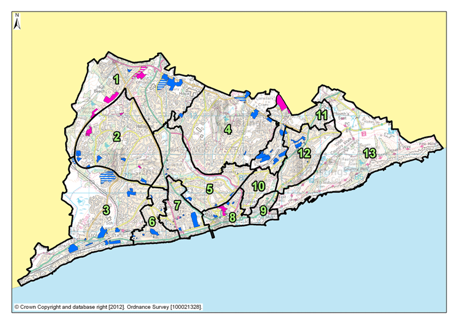
2.3 To help you find the focus area that’s most relevant to you, a map showing the boundaries for each of the focus areas is shown below.
Figure 1: Map of Planning Focus Areas
Focus Area 1: Little Ridge & Ashdown
(1) 2.4 This is where Hastings’ urban fringe meets the surrounding countryside, with recent housing developments edging into woodland, fields and farmland. It is where visitors to Hastings arriving by road from London get their first glimpse of the sea, with long, often breathtaking views, especially from high points on The Ridge.
2.5 Little Ridge & Ashdown covers the parts of the Borough to the north of Silverhill and west from the Conquest Hospital, including semi-rural areas to the west of Queensway. It is a mixed area, with good quality and well maintained, predominately post-war, housing and two of the town’s larger employers: the Conquest Hospital and the Child Support Agency. The area includes a major supermarket whose draw extends well beyond the immediate locality and some of other retail outlets. The presence of various employers in the Focus Area, including tourist accommodation at the Beauport Park holiday village, the Premier Inn and Bannatyne’s hotel and spa, and leisure developments, together create the opportunities for people to live and work in relative close proximity, and a mix of housing allows local workers the chance to walk or cycle to work.
(3) 2.6 There are also good public transport connections in this area to the Conquest Hospital, supermarkets, to Hastings town centre and beyond. This connectivity allows for a choice of travel options for work and pleasure. This connectivity does, however, come at the cost of some particularly busy roads with the junctions of the A259, the A21 and The Ridge
2.7 But Little Ridge & Ashdown is not just a mix of housing and industrial suburbia. There are recreation grounds, allotments and most significantly, the Marline Valley, a Site of Special Scientific Interest (SSSI) which includes woodland, meadows and a steep-sided valley covering forty hectares of open space to the west of Queensway.
2.8 Housing in Ashdown & Little Ridge is predominately owner occupied (according to census data over 80% of the residences are owned by their occupants) and most are suburban family homes. The demographic data for the area (again from the census) reinforces the fact that this is an area where many families live, as it shows an even mix of age groups.
Our Vision for Little Ridge & Ashdown
(2) 2.9 A major change to this area of the next fifteen years is likely to be the construction of the Bexhill - Hastings Link Road. This will allow drivers the choice to travel either on Bexhill Road and Hastings seafront, or onto The Ridge to continue their journeys east and west. It will also allow for better and simpler access to the A21 for travel north towards London, the Baldslow Link will also be an important part of improved road connections. Whilst the Bexhill - Hastings Link Road will improve transport options for local people, businesses and tourists; careful management of traffic flow, especially at existing major junctions, and near potential development sites, will need to be considered. Development proposals all along The Ridge will need to show consideration of the traffic impact onto and off of this locally important traffic route.
(1) 2.10 Building the Link Road could also aid in the development of commercial and employment areas along Queensway, and particularly at the northern end. Better traffic flow in these areas will help to increase the opportunities for improved access to the sites. This is as an opportunity for new commercial developments, offering extra employment opportunities, but this should not be to the detriment of ecology, particularly the woodland, of the area.
(1) 2.11 Public open spaces are important here in blending the urban area into the surrounding countryside. The Marline Valley SSSI will continue to be protected. Allotments and open spaces are important to local communities and these will be managed and where possible enhanced so that their enjoyment is available to all whom would like it. Tourist accommodation provision in Little Ridge & Ashdown is something that the Council would also like to see protected and we will consider ways to enhance it.
(1) 2.12 Policy FA1 of the Hastings Planning Strategy states that the provision for 220 – 280 extra homes is required in Little Ridge and Ashdown, over the next fifteen years and most of these will be delivered through new development on allocated sites. There is a particular development opportunity at Holmhurst St Mary, a former convent school and surrounding grounds, land next to it at 777 the Ridge and the neighbouring playing field. Together these sites have the potential to provide a significant number of new homes, with a mix of properties for all, including families, workers for the hospital and employees of the local light industrial and commercial sites. A benefit of these sites coming forward together in a well phased manner could be to allow for an integrated development, including an improvement to the recreation facilities and the opportunity for the community to take some ownership and for locally important wildlife habitats and green spaces to be protected and also properly connected.
2.13 South of The Ridge West and along Queensway there are opportunities to increase the volume of industrial and commercial premises and to strengthen the links between the Hastings labour force; its exports and the wider market of the UK and beyond. The proposed Bexhill - Hastings Link Road will aid in the continued growth of business and employment in this part of the Borough. Situating these kinds of premises near to one another increases the opportunities for similar businesses to set up and share expertise and knowledge. The new commercial area on Queensway – the Queensway Employment Corridor – with the Enviro 21 Park, an environmentally sustainable industrial park, will act as a catalyst to other businesses and premises and with the Sussex Exchange Business Centre, employment opportunities in this area have a strong future.
2.14 The eclectic nature of architectural styles in Little Ridge & Ashdown allows for development proposals, be they large or small, to have a degree of flexibility. There is a need to provide a mixture of tenures in the area, where possible, to maintain a sustainable community, which has access to a range of local shops and services. We will continue to encourage the inclusion of affordable and social housing in schemes, especially in this Focus Area, where there is less provision than elsewhere. Affordable housing, especially for locally employed people, potentially a small amount of flatted development and also some larger family homes will maintain the suburban feel of this area of the Borough, and help to maintain the quality of the built environment.
Focus Area 2: Greater Hollington
2.15 Lying outside of the main town centres, this planning Focus Area includes a broad mix of different characteristics and uses, covering housing, factory estates, retail and protected open space. Bordered by Battle Road in the east and the sweeping curve of Queensway in the west, it extends from the Asda superstore at Silverhill to open countryside on the western edges of town.
2.16 The majority of housing here is post-war with the Four Courts (Hastings’ only dedicated housing tower blocks) forming a very striking part of the homes. But there are few flats otherwise. A lot of the housing is family houses with gardens. Much of the housing in this Focus Area is the product of extensive urban growth and expansion projects of the last 30 years. There are, however, occasional pockets of older pre-war cottages that once stood in villages, before Hastings Borough extended across them.
2.17 There are 3 major industrial estates here: Castleham, Churchfields, and Ponswood. These are well-used and provide a significant contribution to local employment, with employers such as General Dynamics, Marshall Tufflex and Deutch. The town’s largest single retail store is here too, the Tesco Extra superstore on Church Wood Drive. The area is reasonably well served by local convenience stores, has doctors’ surgeries, and community centres.
2.18 But Greater Hollington is not an unending suburban sprawl of housing and factory estates. There are plenty of open spaces here, and some of the most important ecological habitats in town, notably at Church Wood and the neighbouring Robsack Wood nature reserves. Walking through these ancient woodlands, it feels as though you’re far out in the country side, not a few hundred metres from shops and factories.
2.19 Even outside of these nature reserves, Greater Hollington, has an open, spacious feel. There’s Hollington Park (comprising Ponds wood and Gillsman’s wood), and many smaller open spaces, allotments, playing fields, and houses with gardens. This sense of space might, though, be some what misleading as the population density is relatively high at 68 people per hectare (according to census data).
2.20 This Focus Area has the second highest population of the 13, with a high proportion of families with children. Census data shows that more than a fifth of the population are children under 16, and this is possibly indicative of this area being the third highest for the proportion of families with children. And there is significant economic deprivation here. It is the fourth most deprived area of the borough, with a quarter of the adult population on out-of-work benefits (according to the Department of Work and Pensions – Nomis statistics); more than a third of the children live in families with incomes below the official UK poverty level (Office of National Statistics) and nearly 50% of households are social rented.
2.21 So this is an area of contrasts: successful businesses and unemployment; high-rise housing and bungalows; factory estates and nature reserves.
Our Vision for Greater Hollington
(1) 2.22 We want Greater Hollington to retain its open, spacious environment, while remaining as the one of the principle employment areas of the town. To achieve this, it will be essential to retain the protected open spaces, parks, allotments and nature reserves between housing and factory estates.
2.23 The architectural heritage of Greater Hollington is rooted in the expansion of Hastings Borough during the second half of the 20th century and particularly the last 30 years. So whilst an appreciation of the built environment in this area is important there are particular opportunities for creativity of new development here. Over the next 15 years, Policy FA1 of the Planning Strategy sets out a need to plan for 250-310 new homes to be built in this area; there is the scope to provide a range of housing types and tenures with a mix of family homes with gardens, and smaller residences for single people and couples. Schemes for development in Greater Hollington should reflect the spacious feel of the surrounding area and a particular part of this should be good design, with a focus on environmental efficiency that minimises fuel costs.
(1) 2.24 We would especially welcome applications to renovate or redevelop industrial premises, especially in ways that minimise energy consumption and protect natural resources. More retail premises could also be considered, although not big, out-of-town retail supermarkets – rather, smaller shops that serve a more local community. And we would consider proposals to blend the currently quite rigid boundaries between industrial and residential areas, with the possibility of small, modern workshops mixed in with housing, and possibly live/work units. We would not, however, want to see the space allocated for employment purposes in the area reduce overall. Increasing the opportunities for employment is one way to help reduce the numbers of people on Job Seeker’s Allowance.
2.25 Development in Greater Hollington should be attractive, imaginative, and environmentally sustainable. We want to see the area develop as an environmental showcase of innovative design, blending housing and industrial uses into the natural green spaces that will continue to be at the heart of its communities.
Focus Area 3: Filsham Valley and Bulverhythe
2.26 Extending from West Marina in the east and Queensway in the north, to the western boundaries of the borough, this is an area of contrast between 20th Century housing, commercial depots, and wetland nature reserves. When travelling by train from London, this is where visitors get their first impression of Hastings & St Leonards as they glimpse the sea across school playing fields and open spaces that follow the valley to the coast at Bulverhythe.
2.27 The coastal strip was the first part to be developed, along Bexhill Road. Around West Marina Gardens, housing is Victorian and Edwardian, where some of the former grandeur has faded. Recent years have seen a revival however, with much of this housing renovated. Further west, the old bathing pool site remains a development opportunity, alongside the beach chalets here and those at West of Haven further along. Beyond this, the housing along Bexhill Road is generally that built between the wars. There are industrial areas here too and Brownfield development sites, such as the old West St Leonards school and the Bulverhythe Depot.
2.28 Inland, the housing is more modern, built mostly from the 1930s through to the late 20th Century, the most recent development on a former golf course. East of the Hastings Line railway, the houses are older, larger and mostly detached. This part of the area has a different feel; quieter, more peaceful, an urban fringe with leafy suburban streets in the east to nature reserves to the west, and surrounding countryside. The St Leonards Academy, on the old Filsham Valley school site, is present and the creation of the academy has the potential to open the Grove School site as another development opportunity in Filsham & Bulverhythe.
2.29 There are shops scattered through Filsham & Bulverhythe, cafes and takeaways, several larger retail warehouses, a garden centre, car dealers, assorted other commercial premises and a small community centre. This Focus Area also contains the West St Leonards railway station on the Hastings Line between Ashford in the east and London to the north.
2.30 The beach and coastline here is relatively isolated. Access to it is challenging because it is cut off from the town by the Hastings to Brighton railway line, and to some extent the A259 Bexhill Road. North of Bexhill Road, there are two nationally important wetland nature reserves: South Saxon wetlands and Filsham Reedbeds, within the Combe Haven SSSI. There are playing fields too, and the Combe Haven holiday park, an important source of tourist accommodation.
2.31 According to Census data, 8,500 people live here and almost 50% of them are over the age of 45; this is higher than any Borough average. It is the third least deprived Focus Area of the 13 (Office of National Statistics). Census data also shows that 80% of the housing in this Focus Area is owner occupied. The A259, Bexhill Road, dominates the southern part of the Filsham & Bulverhythe Focus Area, but with the announcement of the Bexhill-Hastings Link Road and the route options for journeys that this will bring, the congestion along this road should be reduced. Public transport options are good and the recently completed cycle route along the seafront has created another way for people to reach Bexhill, and the beach, so connectivity in this Focus Area is good.
Our Vision for Filsham & Bulverhythe
2.32 Of all the Focus Areas in the borough, Filsham & Bulverhythe has the potential to see the most change. There are some larger Brownfield development opportunity sites here, which could be developed as housing. Policy FA1 of the Planning Strategy identifies that this area has the potential capacity for, between 630 and 700 additional homes over the next 15 years. With some of the largest sites in the borough available here, we would expect to see some innovative and imaginative uses of the land. Higher densities may well be possible, if suitably achieved, with perhaps limited flatted developments. But there is a need to retain employment sites, so some existing commercial premises should be kept for employment purposes and their quality and use maintained and improved where possible.
2.33 However, the area is low-lying and in a designated ‘flood risk area’. Flood risk, and getting adequate drainage in place, is a significant challenge here.
2.34 When the Link Road is built, this will make a big difference to Bulverhythe & Filsham Valley, both along Bexhill Road and along Filsham Road. Together with the new cycle path, we would expect to see more people using the beach and sea, and tourists attracted to this area. So there is likely to be the opportunity for more facilities for them: cafes, small shops, sports, possibly licensed premises, close to the beach access points. Consideration may be given to proposals for cafes on the beach side of the railway line. We want this part of the area to come to life, to shake off its ‘edgelands’ feel, and reinvent itself. Innovation and imagination offer the potential to help maintain and strengthen the economy and community of this part of the Borough.
(1) 2.35 The former bathing pool site at West Marina remains one of the most prominent development sites on Hastings sea front. During the next 15 years, we expect this to be developed for both homes and leisure use. Because the site is prominent, potential schemes here would need to pay particular attention to good design and innovation something, perhaps, that would be a tourist destination in itself. However, we recognise that it may be a while before such a development is viable, so innovative temporary uses for the site would be encouraged in the meantime.
(4) 2.36 The SSSI’s along Combe Valley will remain protected from development, beyond improved visitor facilities, although these would need to be restrained and environmentally sustainable. And we would want to retain important tourist accommodation at Combe Haven holiday park. Public playing fields and allotments elsewhere in the area will also continue to be protected.
Focus Area 4: St Helens
2.37 This Focus Area is dominated by St Helen’s Wood, a local nature reserve with meadowland, woodlands, ponds and streams. To the northern end, St Helen’s Wood joins with playing fields and open spaces at The Ridge and out to the High Weald countryside beyond. The St Helens Focus Area stretches from Parker Road in the east to the Conquest Hospital, and from St Helen’s Road in the south up to the northern edge of the borough at The Ridge.
2.38 Housing in St Helens is mostly 20th Century post war, although there are Victorian terraces and larger 19th Century detached homes in the south east of the area. Elsewhere, there are a few older houses, once more rural homes that have been overtaken by Hastings’ expansion. This is a Focus Area where there is another very eclectic range of homes and architectural styles. Around St Helen’s Wood nature reserve there are individually designed homes, with large, often wooded gardens. Away from the woods some of the housing is more modest.
2.39 Although this is primarily a residential area, St Helens is also home to William Parker School, the borough’s boys’ secondary school. There is also the cemetery and crematorium, Hastings United football stadium at the Pilot Field, the Firs former football ground, and various playing fields and allotments. St Helens is less well served by shops and employment than other Focus Areas, with most services being just over the borders into other areas. There are some individual shops, pubs and facilities but residents of St Helens often have to travel to get to their jobs and the services they need with Census data suggesting car ownership in this area is high, which reflects this fact.
2.40 This is one of the most populous of our Focus Areas, with 11,000 inhabitants, although it is also one of the largest by area. It is the second least deprived part of the borough (ONS), and 78% of the homes are owner occupied (according to census data). The population here is older than the borough average, with more than a third above retirement age, the second highest in the borough (Census).
Our Vision for St Helens
2.41 The Planning Strategy sets out the requirement for 210-250 new homes to be built in the next 15 years; with most potential development opportunities on Elphinstone Road and The Ridge. Where new development does occur, we would expect it to be in keeping with the suburban and semi-rural nature of the area. Densities of new developments are likely to be higher than current low-density housing. Small flatted developments could be acceptable, with a mix of designs to include houses with gardens where appropriate. Social rented and affordable housing would also be encouraged here, as there’s currently little of it in this area.
2.42 In order to maintain and enhance the communities here opportunities for mixed use development to include local services could be investigated and the inclusion of live/work units may be appropriate. We will encourage the retention of existing employment land in St Helens that is at a premium. Development proposals, particularly along The Ridge, will need to show consideration of the traffic impact onto and off locally important traffic routes.
2.43 St Helen’s Wood nature reserve will remain protected from development. Any development at the edge of St Helen’s Wood will need to be particularly sympathetic to the character of the reserve, and schemes should aim to preserve views and access to the undeveloped wooded edges. Whilst development proposals on the main roads and particularly The Ridge will need to appreciate their potential impact on traffic locally, especially when the new Bexhill-Hastings Link Road is built and new regular routes through Hastings’ Borough are established.
Focus Area 5: Silverhill & Alexandra Park
2.44 From the edges of the town centre to the Silverhill shopping centre, this Focus Area follows the course of Alexandra Park, from its formal greens and gardens at the southern end to the wild and wooded reaches of Shornden and Old Roar Gill, a waterfall that tumbles into a narrow gorge filled with ferns and mosses.
2.45 Housing to the southern end of the area and around Silverhill centre is largely Victorian. Elsewhere, the housing is mostly inter-war, with some very elegant Art Deco houses along the edge of Alexandra Park. The area has shops and other facilities, most of these are in the Silverhill shopping area. There is less to the south, where local people are more likely to go to Hastings Town centre for shopping, doctors, and other facilities.
(1) 2.46 Employment in this Focus Area is generally centred on the Silverhill shopping centre, with a few small industrial premises, as well as retail. There is also a crop of civic buildings along Bohemia Road, including the law courts, Hastings principal police station, a fire station, ambulance station, some industrial units, and Horntye Sports Centre, including Hastings cricket ground. This part of the area also includes some interesting archaeology, including an old ice house and the ‘roman baths’.
2.47 The area is characterised by urban green space; to the west, Summerfields Woods, a local nature reserve and to the east the border runs along the eastern edge of the award-winning Alexandra Park, the borough’s principal urban park. Alexandra Park includes the usual seaside attractions at the southern end, where there’s a busy cafe, flower gardens, children’s playground, tennis courts, bowls and lakes. Further up, it becomes more natural with woodlands and fishing lakes. And there’s Summerfields Woods, a local nature reserve in a steep-sided wooded valley, where you can find the remains of an old walled garden, now being restored. There are allotments in this area too, and other small green spaces.
2.48 In spite of all the open space, there are still over 10,000 people living in this Focus Area, with some parts, around Silverhill especially, relatively densely populated (40 people per hectare according to the Census). The age range of the population is evenly spread, displaying a mix of families with children, working age people and retirees.
2.49 The tenures in this focus area are two thirds owner occupation according to Census data and, in contrast to many of the other Focus Areas; there is a relatively high proportion (21%) of private rented accommodation in Silverhill & Alexandra Park. This last statistic could be reflective of a local population that is potentially less likely to stay in the same home as long as home owners.
Our Vision for Silverhill & Alexandra Park
2.50 This is an area dominated by protected open space; the award-winning Alexandra Park, nature reserves, allotments and public playing fields. The significant public open spaces will be protected and enhanced. In particular, we would like to see better connections between Alexandra Park, Summerfields Woods, the town centre and seafront, with walking routes, cycling routes, and public transport key to this. We will encourage their use and perhaps increase community management.
2.51 Policy FA2 of the Planning Strategy plans for 300 - 360 new homes here over the next 15 years; a particular opportunity site could be at the Horntye sports centre. Given the relatively high densities of population in this Focus Area, and also the presence of Alexandra Park and other open space, potential development schemes will need to pay particular attention to innovative design to find solutions that address density and complement the open spaces. Opportunities to protect and enhance the connections for people and wildlife between the green spaces in this Focus Area should be fully investigated in connection with any development scheme that comes forward.
2.52 Silverhill is the commercial hub of the area, and we would expect this to remain so, and indeed to develop and improve as a retail centre. Here, there could be an opportunity for innovative design, so ideas for modern, commercial or retail development would be welcome. Away from the retail centre, Silverhill has other employment sites, and we would encourage their retention, there could be the potential to integrate appropriate employment opportunities into the more residential areas, including for example small workshops or live/work units.
Focus Area 6: Maze Hill & Burtons’ St Leonards
(2) 2.53 This area covers the ‘historic’ part of St Leonards, from the 1930s Art Deco Marine Court on the seafront, to Markwick Terrace and its surrounding streets, extending in the east from London Road to the edge of West Marina gardens. Much of Maze Hill & Burton’s St Leonards has conservation area status. It’s characterised by a mixture of Regency and Victorian Villas and imposing terraces characterised by elegant gleaming white housing, interspersed with formal gardens at Markwick Terrace and St Leonards Gardens (one of two parks in the borough that are on the English Heritage Register of Parks and Gardens of Special Historic Interest).
(1) 2.54 Burtons’ St Leonards itself is of great architectural and townscape interest as it forms the core of the original Regency new town designed and built by James Burton and his son Decimus between1828 – 1835. Their vision included a mix of architectural styles, from Scottish baronial ‘castles’ to mock-Tudor manor houses. To the south west of the area is Mercatoria, the old ‘tradesmen’s’ area built to serve Burton St Leonards. Here, houses are smaller, and have suffered from considerable neglect, although are now improving through the general regeneration of this part of St Leonards. There are specialist shops, including antiques dealers and art galleries. The seafront here has undergone some regeneration and is slowly returning to its former 19th Century splendour. Beyond Burton St Leonards and Mercatoria, to the west in particular, there is some more recent housing, in small pockets, ranging from 1950s detached houses to late 20th Century terraces.
2.55 This is one of the smaller planning Focus Areas. According to Census data just over 4,500 residents live here, and half of them are over the age of 45 (older than the average Hastings resident). There are fewer families with children in the area, with the lowest percentage of under 15 year-olds in Hastings, but a significant number of households with older people. Some of the larger houses in the area have been converted into residential homes for older people. There are a limited number of shops and other community facilities here.
2.56 Census data puts population density in Maze Hill & Burtons’ St Leonards at just under 39 people per hectare. The area has parts that are more densely populated than others and this reflects the relatively small but closely built buildings towards the seafront and the larger properties further inland, as well as the green spaces in between. There is a mix of housing tenures in Maze Hill & Burtons’ St Leonards but it is dominated by two kinds, with over 70% of the homes in the Focus Area being owned by their inhabitants and a relatively high, compared to other Focus Areas, being privately rented (19%).
Our vision for Maze Hill & Burtons’ St Leonards
(2) 2.57 This Focus Area is characterised by statement, often pastiche, and interesting architecture, much of which is in conservation areas. As such there are certain expectations over the design and materials that are used in any potential development schemes. Early assessment and appreciation of the situation of any proposed development will be particularly important in Maze Hill & Burtons’ St Leonards and the design and layout should be sympathetic to its surroundings. Where it is appropriate schemes that involve a mix of housing that includes family homes will be encouraged. We are planning for 240-300 new homes to be built in the area over the next 15 years. The most significant redevelopment site in the area is at the old Hastings College site on Archery Road.
(1) 2.58 Mercatoria, which was built as the ‘commercial’ part of Burtons’ St Leonards, offers great potential to increase the number of specialist shops and artist studios for which this area of the Borough is known. Live/work units and innovative smaller projects, for example for artists, food retail and catering will be encouraged.
(1) 2.59 Elsewhere, there may be further opportunities for developing small studio-style live/work units, particularly as a way of renovating properties. The nature of this area has the potential to lend itself well to tourist accommodation, particularly in the form of small, boutique hotels and guest houses.
2.60 Along the seafront, we will continue to encourage improvements to properties wherever we can. We will work with partners to promote and improve buildings to create better quality accommodation, but would want to retain the overall period look of the seafront, with the exterior of buildings restored to their original specification wherever possible.
Focus Area 7: Central St Leonards & Bohemia
(1) 2.61 Extending from White Rock gardens in the east to Grand Parade in the west, and inland to the Bohemia road shopping area, this is the most densely populated part of the borough, with approximately 85 people per hectare, and almost 9,500 residents. It is also the second most economically deprived (ONS) with almost 20% of the working age population claiming Job Seekers Allowance (Department of Work and Pensions – Nomis statistics).
(1) 2.62 In spite of the high population density, there are some significant open spaces, notably Warrior Square with its formal, seaside planting, White Rock Gardens, and Gensing Gardens. St Leonards Warrior square railway station is here too, at the heart of the shopping centre. Housing here is mostly terraced and Victorian, with many Houses in Multiple Occupation (HMO). The employment here is predominately shops, and public sector employers such as the Revenues & Customs and Social Services offices at Ocean House.
(1) 2.63 After the waning of its Victorian heydays, Central St Leonards & Bohemia, in recent years, have begun to change. Around St Leonards Town Centre and the seafront, significant regeneration has taken place. Many derelict properties along the seafront have been refurbished, and a new health centre has been built on the site of the long-derelict Marlborough Hotel. More recently, new ‘boutique’ hotels have opened, nationally promoted as fashionable places to stay. Around St Leonards centre, some of the narrow streets in Mercatoria have seen an up-lift, with owners refurbishing previously run-down properties. And the shopping centre itself is changing fast, with an influx of new cafes, restaurants and shops and significant investment having taken, and continuing to take, place along many of the shopping streets.
2.64 This is also an ethnically diverse part of town, with many different nationalities represented, which has led to the opening of many niche shops, cafes and restaurants, to meet the needs of these particular parts of the community but also for interested visitors. This trend too has contributed well to the positive regeneration of the Focus Area.
Our Vision for Central St Leonards & Bohemia
2.65 The regeneration of this area has begun, but it is only a start. We need to encourage new businesses to the area, retail in particular, but tourist accommodation in the shape of more ‘boutique’ hotels particularly along the seafront is important. Other businesses in the creative sector would especially fit in well with the mix and atmosphere of this area. So we’ll do all we can to encourage small businesses, and work with them to promote and establish themselves. We expect St Leonards centre to become a focus for independent and niche shops, cafes and restaurants, something that serves the local community as well as being a tourist attraction. This is something that we will investigate through the potential for a cultural quarter in this area promoting joint working between the Local Authority, business owners and the local community.
(1) 2.66 Policy FA2 of the Planning Strategy indicates a range of 240-300 new homes to be planned for here over the next fifteen years. This is a town centre where flats and small terraced houses can provide low-priced starter homes for younger residents. We will expect these to be of innovative design, creating good quality homes, with a mix of ownership, rented and affordable housing. Bringing empty housing back into use will also contribute to the new homes totals.
2.67 The seafront will also continue to improve, becoming more of a tourist destination, connecting with St. Leonards centre. As well as using enforcement powers to get property owners to improve their buildings, we will investigate and encourage, where appropriate, quality conversions of properties to visitor accommodation particularly along the seafront. To retain the character of the seafront we will be encouraging restoration rather than replacement of properties, at least externally. The council-owned seafront structures, especially ‘Bottle Alley’ will also need major refurbishment. We anticipate that changes here will mean the creation of catering and retail spaces on the seafront, and will do all we can to encourage local businesses to take up these opportunities.
2.68 To the north of the area, around the Bohemia shopping centre, the decline of the retail centre needs to be managed. We will investigate the possibilities here, including retail, catering, workshops, live/work units, or even conversions back into residential properties.
Focus Area 8: Hastings Town Centre
(1) 2.69 This Focus Area is the commercial and retail heart of the borough, extending from the Old Town in the east to White Rock in the west, and inland as far as Summerfields Wood and the Hastings Line railway between London and Ashford. Most of the town’s comparison retail trade takes place here, and the tightly constrained physical boundaries of Hastings have generally prevented the development of out-of-town shopping.
2.70 Hastings Town Centre has a good representation of national high street retail, catering and other business chains and there are also many independent shops, cafes and bars. The latter are predominately in the traditional shopping areas along Robertson Street, Queen’s Road and in St Andrew’s Square and Queens Arcade. Morrisons supermarket also occupies a significant part of this Focus Area. Many of the shops of Hastings Town Centre are Victorian, although newer buildings have replaced them in some areas, notably in the modern Priory Meadow shopping centre, where the Victorian cricket ground on which it stands is remembered with the bronze sculpture of a batsman.
(2) 2.71 The architecture of Hastings Town Centre takes on many forms and patterns. There are Victorian terraces; mid 20th Century retail blocks and very recent retail, office and educational developments. There are also many separate and distinct buildings including Pelham Crescent, St Mary in the Castle and the Brassey Institute. There are also lesser know gems too, such as the Victorian warehouses along Duke Street. This is another Focus Area where eclectic architecture has, and continues to, help define its character. There are tourist attractions, such as the White Rock Theatre, Hastings Museum and Art Gallery, and the seafront itself. And there are residential areas too, predominantly around St Andrew’s Square, Wellington Square and Holmsdale Gardens.
2.72 Significant regeneration has taken place, notably the Lacuna Place development and 1 Priory Square, Sussex Coast College, the improved railway station, a new health centre and the Hastings campus of the University of Brighton. Major improvements to the seafront through ‘grotbuster’ enforcement action, with many of the formerly derelict seafront buildings now refurbished and back in use, have also occurred. But significant regeneration challenges remain: White Rock Baths, the Observer Building, and Hastings Pier all remain out of use, although the pier does now have a hopeful future, thanks to a Heritage Lottery grant and the Council’s compulsory purchase of it.
2.73 Around 3,500 people live in Hastings Town Centre (according to Census data) and these are predominantly young adults. Almost 50% of the houses in this Focus Area are owned by their occupants and also a relatively high proportion (38%) of homes are privately rented and of these a number are Homes in Multiple Occupancy, this suggests a relatively transient population. Around a fifth of the working age population of this Focus Area are in recipt of Job Seeker’s Allowance (Department of Work and Pensions – Nomis statistics). The residents are able to access a high level of services and facilities: doctors, dentists, a library and more all within the Town Centre, but there are also good public transport connections especially at Hastings’ railway station and the adjoining bus interchange, providing the opportunity to travel further afield.
Our Vision for Hastings Town Centre
2.74 Conservation areas cover much of the Hastings Town Centre Focus Area, and because of this, there are extra guidelines over what form development can take. It will be important for many features of the Focus Area to be preserved and enhanced; nevertheless there are still great redevelopment opportunities where innovation and excitement can prevail consideration will be given to the appropriate inclusion of taller buildings.
2.75 Outlined in the Planning Strategy (Policy FA2) is the potential for another 20,500 square metres of comparison retail floor space, and this should be accommodated within the Town Centre boundary, so redevelopment opportunities could be suggested.
2.76 In particular, we want to see the development of Priory Square continued, including the rest of Havelock Road north of Lacuna Place, Queensbury House, and Priory Street, to create employment, retail and leisure uses. The Observer Building and White Rock Baths need to be brought back into use too.
2.77 There are opportunities in Hastings Town Centre for residential development – town centres are a good location for homes; particularly good-quality flats, especially as starter homes for young people. Introducing new housing into town centres can improve the balance and ‘feel’ of a place, especially at night. Policy FA2 of the Planning Strategy sets the range of new homes provided in Hastings Town Centre over the next fifteen years at 200 - 240.
2.78 Improvement and refurbishment of some of the residential areas and tourist accommodation has begun in the Focus Area and we will encourage the continuation and expansion of this where appropriate across Hasting Town Centre.
2.79 On the seafront, we expect to see Hastings Pier and White Rock Baths brought back into use. We will do all we can to help Hastings Pier and White Rock Trust build a modern, regenerated pier, and will help the Foreshore Trust get White Rock Baths back in use, with possible temporary uses for the upper parts initially. Further east, we anticipate that the seafront will continue to be used for leisure and catering purposes, although would hope to see these further developed and improved.
Focus Area 9: Old Town
2.80 Hastings Old Town is the oldest part of the borough, extending between the East and West Hill from the iconic net shops on the beach, up to All Saints Church at the head of The Bourne. Some of the housing and other buildings here date back to the thirteenth century, woven through a maze of narrow streets and twittens that delight both visitors and residents.
2.81 The Old Town has had a mixed history of twentieth century planning, for example the demolition of housing along The Bourne to create a route for the A259 effectively divided the area in two and was a low point but there are large areas of sympathetic 1970s redevelopment. The Old Town remains a desirable place to live: house prices here are the highest in Hastings. It is also the densest housing in the town, with few open spaces, although it is very close to the Country Park and West Hill. All of the Old Town is in a conservation area, and many of the buildings are Grade II listed.
2.82 Census data shows that the population in the Old Town is the oldest in the borough, with around a third of them above retirement age. By contrast, only a tenth of the population are under 16, the lowest in the borough. New community facilities at the Stade Hall help to provide a centre for local community activities and the area is reasonably well served by other community services, with a doctor’s surgery, pharmacy, and local food shops.
2.83 There is various employment in this Focus Area; the Hastings fishery at the Stade, with its direct employment of fishermen, as well as many indirect jobs, in related onshore trades, and the tourism that the fishing industry brings with it. There is much employment in retail and catering too, with a thriving network of busy, independent shops and cafes and pubs along George Street, High Street and Rock-a-Nore. There is also a wealth of small studios and workshops, used largely by working artists and other craft-related trades. There is also some more seasonal employment concentrated on ‘traditional’ tourism, with souvenir shops, amusements and all that is on offer on the seafront.
2.84 New development has taken place in the Old Town in recent years, most notably the Jerwood Gallery, Stade Open Space, cafe and Stade Hall, with the style and design of this being modern and creative but sympathetic to its setting. There is new hotel in Rock-a-Nore being built, replacing the old ice house that had been derelict for many years. This helps to give visitors to Hastings a great range of things to see and do during their time here, from traditional seaside amusements, to eating and drinking, to art appreciation and everything in between.
Our Vision for the Old Town
2.85 Since the charm of the Old Town, and its value as a place to live and work, is dependent on its centuries-old character, any new development would have to be sympathetic to this. Almost all of the buildings in the area should be maintained and preserved in their current form, retaining its rich architectural heritage. But this does not mean that there should not be any new development. So we will allow new development in the Old Town, where this complements the existing townscape, and does not damage existing historic buildings, both in terms of their physical structure and their visual setting. Any new development here would have to be carried out to the highest architectural quality. But that doesn’t mean it has to be a mock-historical pastiche: the Old Town must continue to grow and react to changing times.
2.86 This approach obviously raises potential conflicts, in particular between businesses wanting to develop opportunities, and the need to conserve architectural heritage. So while we will continue to pay close attention to the materials and construction techniques used in the conversion of existing buildings, we will work with those looking to develop schemes and help them to achieve their aims and aspirations whilst the character and important buildings of the Old Town are preserved for future generations.
2.87 Policy FA5 of the Planning Strategy sets out a range of 50-70 new homes to be built in the Old Town during the next fifteen years, but businesses and new jobs will be just as important. With the average age of the local population growing, and being significantly higher than the rest of the borough, it’s important to make sure that young people can remain in the area. That will be difficult if there are no jobs apart from seasonal, tourism-related jobs, and no affordable housing. So we need to promote the creation of both affordable housing, and sustainable employment, particularly with small employers in the creative sector.
Focus Area 10: West Hill
2.88 The West Hill Focus Area is made up of mostly terraced Victorian housing, stretching from the West Hill open space, with its spectacular views across the town and sea, to Mount Pleasant in the west and Torfield allotments in the east, while extending to the north as far to the edge of Halton Estate.
2.89 At the southern end stands the borough’s only Grade I listed building: Hastings Castle. The housing near the Castle is elegant, seaside villas, although some could do with some work doing to them. Some of the big, cliff top hotels and boarding houses have also been converted into flats or houses in multiple occupation.
2.90 Moving inland, the houses get larger and more densely packed. Streets here are narrow and lined with parked cars, with few open spaces between, giving the feel of a crowded, highly populated area. Families with children predominate: the area has the lowest proportion of retired people in the borough, but the second highest proportion of children under 16, according to Census data.
2.91 Some gentrification has taken place in the terraced cottages closest to the cliffs, with many of these refurbished and turned into holiday lets or weekend retreats. Most of the housing here is private, beyond a few small infill blocks of ex-council flats.
2.92 Census data supports that this is a busy, densely populated part of town, with over 5,500 people living here, in one of the smallest Focus Areas. The density of population does mean that corner shops, small businesses and local pubs have survived relatively well. There are even some ‘traditional’ workshops and light engineering businesses, mixed in amongst the Victorian terraces. One fifth of the working age population, however, are in receipt of Job Seeker’s Allowance (Department of Work and Pensions – Nomis statistics). While the area is well-served by open spaces and children’s play areas, these are all at the southern and eastern edges of the area.
Our Vision for West Hill
2.93 Hastings Castle, owned by Hastings Council, needs considerable investment to bring it up to standard as a tourist destination, making the most of its status as one of the world’s most famous buildings. The vista of open space and elegant housing that surrounds the castle should be preserved. We would, however, encourage the continued development of holiday accommodation in this ‘cliff top zone’, helping the renovation and regeneration of housing back along the streets that lead away from the sea. With local shops serving a community of holidaymakers and residents, enjoying sea views and sunshine amongst pretty, colourful streets and seaside gardens, this part of the Borough will continue to be a prime destination.
2.94 However, this whole Focus Area contains few opportunities for new development: the densely packed terraces would make this difficult. Policy FA2 suggests a range of 60-80 new homes to be provided here over the next fifteen years, in the West Hill the redevelopment and reuse of existing buildings will be an important part of this. Potential development schemes would have to pay particular attention to local population density, the setting of the Castle and be sympathetic to the character of the Victorian terraces.
2.95 The small local shops and businesses in this area are one of its assets, so we would want to preserve and improve these. We would look favourably, too, on ideas for new small businesses, especially from the creative sector. Artists’ studios and workshops in particular would fit in with the feel and atmosphere of the southern part of the area.
Focus Area 11: Hillcrest and Ore Valley
2.96 This t-shaped Focus Area, predominately housing in mid-twentieth century estates, sweeps up from the West Hill to the Ridge and North’s Seat and borders some of the best natural green spaces in town. The quality of the buildings often appears to be in contrast with the spectacular views towards the sea and also northwards to the High Weald AONB. Ore Valley & Hillcrest also includes the Ivyhouse Lane industrial estate, one of the borough’s principle employment areas. This is on the northern edge of the area so somewhat disconnected from the many areas of housing that predominate here.
2.97 Hillcrest & Ore Valley is dominated by social housing, in estates built in the 50s and 60s: Halton, Farley Bank, Broomgrove, Red Lake and Downs Farm. While some of this housing is semi-detached housing with gardens (as in Red Lake), much of it is flats and maisonettes. Attempts have been made to introduce a more diverse mix of housing, with some blocks of flats demolished. But land values are low and there has been little interest shown by developers so the sites remain as development potential, yet to be realised. There are other redevelopment opportunities here too, such as the semi-derelict Malvern Pub, which the Council is intending to buy through a compulsory purchase order.
2.98 This area also includes the Ore Valley regeneration site, formerly a ‘Millennium Communities’ project, comprising an old railway goods yard and power station. Here, some redevelopment has begun, with housing built around a new road to the Ore railway station where new offices and shops will be provided. Although the redevelopment of this site has begun, it still offers much potential for further growth.
2.99 The Statistics for this Focus Area make for hard reading: Over 60% of children live in households below the official UK poverty level (ONS), and there is the highest proportion of children for a Focus Area in the borough. Roughly one fifth of the working age population is on Job Seeker’s Allowance (Department of Work and Pensions – Nomis statistics). Educational and training opportunities are improving significantly though, with the new Sussex Coast College opened in the Ore Valley regeneration area, and the new Hastings Academy at the Hillcrest School site. Other services include community centres and a ‘sure start’ children’s centre but opportunities to increase what is available remain, especially in terms of local retail.
Our Vision for Hillcrest & Ore Valley
2.100 There are already significant redevelopment opportunities on vacant sites at Broomgrove and the Ore Valley. Over the next 15 years, Policy FA5 of the Planning Strategy indicates a range of 440-540 homes are to be planned for. We need a better mix of housing tenures, but any large-scale redevelopment would have to take account of the local economic circumstances, meaning that the current levels of social housing would need to be retained overall, albeit with a better, more integrated mix. While new housing on currently vacant sites could be offered for sale, this is an ideal area for low-cost ‘starter’ homes, giving local social housing tenants a route into property ownership.
2.101 One of the biggest challenges in this Focus Area is the lack of employment opportunities, and the alienation of its young people. To tackle this, we think it is important to bring employment opportunities back into the community, so young people can and their friends can get jobs locally, go to work, and get paid. So as well as protecting and improving existing employment land and industrial areas, particularly the Ivyhouse Lane employment area, we want to encourage the development of small businesses within the community – including live/work units, micro-engineering workshops, high-tech internet-based employers, along with more ‘traditional’ local businesses, such as car repairers and builders. Some of these could be retail units, providing not only employment, but also much-needed local services.
2.102 We must also protect green spaces in the area, which provide an important recreational opportunity especially for children. So where development does occur, the opportunities to help protect and enhance open spaces will be encourages along with, where appropriate the provision of children’s play equipment. This includes the area protected through the ‘Millennium Communities’ project.
Focus Area 12: Clive Vale & Ore Village
2.103 This Focus Area stretches up the Old London Road from the northern edge of the Old Town to the shopping centre at Ore. In the southern part of Clive Vale grand Victorian villas enjoy spectacular sea views. To the north at Ore, the housing becomes part of the ‘ribbon development’ that took place in the nineteenth century in many English towns, along the main roads into the town centres.
2.104 Along this eastern edge, the area is bounded by Hastings Country Park, giving a semi-rural feel to houses where the gardens open out into countryside. The western edge is more urban, and denser, with few open spaces. There is, however, in the Upper Ore valley, a heavily wooded valley that is in multiple ownership where we are working towards a sustainable future for it.
2.105 The area is well served by shops, doctors and other community facilities, although these are largely in the northern part, at Ore Village. But there are also other, smaller local shopping parades at Mount Road and Harold Road, to the south of the area. In Ore Village, however, these services and facilities do cause issues of traffic build up along roads, especially the busy A259, where parking is scarce and footpaths are narrow.
2.106 According to Census data, there are 7,500 inhabitants here, making it one of the more densely populated Focus Areas. It is relatively affluent, however, with 83% of the homes owned by their occupants (Census data). Around 7% of the working population do claim Job Seeker’s Allowance (Department of Work and Pensions – Nomis statistics), but only about 2% of the housing is rented from Register Social Landlords.
2.107 Apart from local shops, there is little employment in this area. The local Victorian trades that would once have been here have all but died out, beyond a few local car repairers and small workshops. In the Clive Vale part, there is a growing community of local artists and craftspeople who work out of home studios, but this is not a significant source of employment for local young people. This is predominately a residential area, there are, however, good road and public transport links across the Borough and beyond to enable people to travel to work.
Our Vision for Clive Vale and Ore Village
2.108 The character of this area is dominated by Victorian terraces and villas, with distant and often dramatic views of the sea. Any new development schemes in this Focus Area would need to be sympathetic of the Victorian patterns and rhythm of development in the area.
2.109 Policy FA5 of the Planning Strategy outlines a range of 250-310 new homes to be provided in the next fifteen years here. Because of the shortage of affordable housing in the area, we would encourage developers who wanted to provide a mix of social and affordable housing. Some of these new homes would also come from bringing empty houses back into use.
2.110 While Clive Vale and Ore Village is likely to remain largely residential, we would consider small-scale employment uses of existing or new property. These should not interfere with the predominantly residential character of the area, but ‘artisan’ trades – for example artist’s studios, specialist craft workshops, specialist niche food makers like bakers or confectioners - could fit with and enhance the area, and provide some local jobs. Tourist accommodation, in the form of small ‘boutique’ hotels, might also be suitable in the grander houses at the seaward end of the area.
2.111 So while we recognise that we cannot fix any areas in cultural aspic, we need to recognise and preserve what is best about Clive Vale and Ore Village, both its architecture and its rare open spaces. But we need to encourage economic development too, especially in Ore Village centre, where regeneration investment is still much needed.
Focus Area 13: Hastings Country Park
2.112 Hastings Country Park is Hastings’ area of true countryside – and it is a very special area of countryside. Gradually acquired by the borough council over a century, it is made up of farmland, wooded glens and crumbling cliff tops that together make up an area of astonishing natural beauty, a wild, sea-edged landscape where rare plants and uncommon wildlife are present, in an environment little touched by development. This special character is recognised through the area’s legal status too. Declared a nature reserve in 2006, it is a Site of Special Scientific Interest (SSSI), and also a Special Area of Conservation (SAC), a designation which gives it special protection under European law. But it is not a wilderness: people have lived and worked here for thousands of years, and the area has a wealth of archaeology to prove this.
2.113 The country park also includes within its boundaries the Shearbarn village, one of the primary tourist accommodation sites in the borough, with camping grounds, caravans and log cabins high on the clifftops looking out over the sea, as well as the smaller Rocklands caravan park.
2.114 The Hastings Country Park planning area takes in slightly more than the country park nature reserve, including the curiously named ‘Bachelor’s Bump’ area at the north-east corner of the borough. This is where most of the people in this area live, although there are a few small pockets of housing in the country park itself, mostly old agricultural housing, coastguard cottages, and the impressive Fairlight Place. Most of this housing is now in private ownership, although almost all of the Country Park is owned and managed by Hastings Borough Council. Even so, while this is the largest of our local planning areas by area, it is the smallest by population: only around 1,800 people live here, with over a quarter of them above retirement age (according to Census data).
2.115 The people that live in this Focus Area generally need to travel to access shops and services as there are few within it. Road connections to Hastings Town Centre are good, and there are bus routes that pass through, the presence of these is important to avoid problems of isolation.
2.116 This is an area where the natural environment is of paramount importance. That means maintaining the unspoilt character of the place for those who visit and live there, but more importantly, preserving the rare and sensitive habitats for the park’s astonishingly varied flora and fauna.
Our Vision for Hastings Country Park
(3) 2.117 Any development anywhere in the country park Focus Area would be tightly managed by existing planning restrictions that apply in SSSIs and the High Weald Area of Outstanding Natural Beauty (AONB). So we are not intending to identify much additional housing in this area to help us meet our overall housing target. Minor development outside of the country park itself could be considered, if it were unobtrusive and wholly in keeping with the character of the AONB. Within the park, any development would be limited to facilities that enhance the park environment and the ‘visitor experience’ – for example, a new visitor centre and café that fits with the Country Park’s aesthetic, or buildings needed for low level sustainable agriculture. Any development would need to be sensitively built and in keeping with the natural environment. We would envisage that any structures in the park would be environmentally sensitive in their methods of construction, use of renewable energy, and water conservation. Environmentally sensitive projects for sustainable energy generation could also be considered. We would want to retain tourist accommodation at Shearbarn and Rocklands too, although any development there would also need to be environmentally sensitive, and limited entirely to tourist accommodation.
2.118 There is the potential in the park to help local people, especially young people, gain experience in the crafts and skills that are used to maintain an area like this should not be overlooked. So while there would be little additional housing development, there is the potential for employment uses, largely of existing buildings, which fostered this kind of activity.