
Hastings Local Development Framework - Core Strategy Informal Consultaton 27 June - 8 August 2011
(1) 5.0 Spatial Strategy
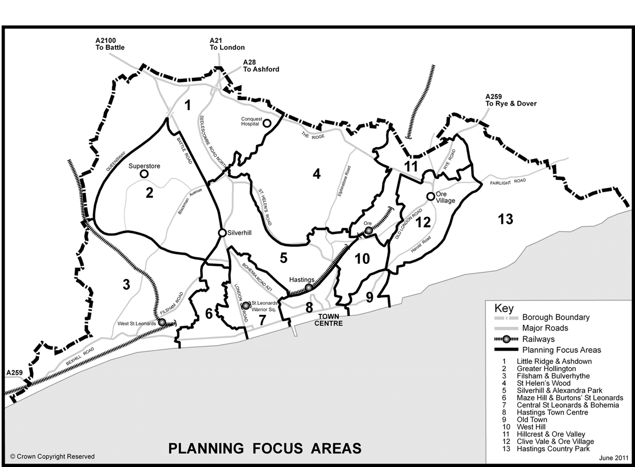
(3) Planning Focus Areas
5.1 To provide a more local perspective and sense of place in the Core Strategy, the town has been divided into a number of planning focus areas - these are broad areas where there is an identifiable community or geography, or where landscape and function means they make a logical area for spatial planning. In some cases they are areas which have common problems and issues. The boundaries have been drawn as close as possible to Super Output Area (SOA) boundaries, as this is the geography used for presentation of important statistics such as the Index of Multiple Deprivation and the Census data. These areas will provide a useful framework setting the scene for the preparation of the more detailed Site Allocations and Development Management Plan, and any Neighbourhood Plans which may be produced by the community.
5.2 The following 13 areas have been identified. Please note the boundaries of the areas are not part of the consultation as they have been developed to reflect the issues set out in 5.1 above.
- Little Ridge and Ashdown
- Greater Hollington
- Filsham Valley and Bulverhythe
- St Helen’s Wood
- Silverhill and Alexandra Park
- Maze Hill and Burtons’ St Leonards
- Central St Leonards and Bohemia
- Hastings Town Centre
- Old Town
- West Hill
- Hillcrest and Ore Valley
- Clive Vale and Ore Village
- Hastings Country Park
5.3 Each of these is shown on the following map
Planning Focus Area map
Proposed spatial spread of housing development
5.4 Future housing growth in Hastings is likely to be spread across the town – there are no major strategic sites of 200 units or more. The pattern of development proposed below is based on an update of the Strategic Housing Land Availability Assessment at April 2011 – an assessment of the deliverability, developability and availability of land for housing available at www.hastings.gov.uk/ldf/shlaa.aspx.
5.5 The majority of new housing will come from sites already allocated in the 2004 Local Plan, and from sites which already have planning consent. This is a direct reflection of the built up nature of the town, with relatively few opportunities for new allocations. Windfall development will also be a significant source of future housing development. Windfall development occurs where a site has not been previously identified as being suitable for housing development and mainly comes about due to redevelopment and changes of use. Analysis of past windfall development shows that it tends to occur mostly in the inner, more densely developed parts of the town.
5.6 Hastings has a relatively large stock of empty homes and the Council is taking action through its Compulsory Purchase powers to bring a number of these back into use each year – this is an issue which local communities have said they want to see addressed. An allowance for the return of empty homes back into use has also been incorporated into the housing figures.
5.7 The Core Strategy is concerned with strategic issues such as the overall distribution of development – there will be the opportunity to comment on individual housing sites when work starts on the Site Allocations and Development Management Plan later this summer
5.8 The table ‘M - Proposed spatial spread of housing development’ on the following page, shows how much housing development could take place in each of the 13 areas up to 2028.
5.9 For each of the areas, the amount of new homes is expressed as a range. This takes account of development in the pipeline, potential new sites and an allowance for both windfall development and the return of long term empty homes back into use. The Core Strategy is required to be flexible and to be able to deal with changing circumstances. The use of the range introduces significant flexibility but at the same time indicates where it is expected that development is likely to be accommodated in the Borough. The detailed allocation of all types of sites, including housing, will follow in the Site Allocations and Development Management Plan.
5.10 We will monitor housing completions against the overall target. If the rate of completions is falling below acceptable levels, we will carry out a review of housing sites to identify any barriers to delivery and work with the development industry to bring forward sites.
Proposed spatial spread of employment, office and retail development.
5.11 The table on page 24 sets out where the major growth in employment related development is planned to occur in the period up to 2028. Hastings town centre will continue to be a focus for change and growth; along with infill and extension opportunities at some of the town’s existing employment estates.
(12) M - Proposed spatial spread of housing development
| Area | Name | Potential range of dwellings by Area |
|---|---|---|
| (1) 1 | Little Ridge & Ashdown | 210 – 310 |
| (2) 2 | Greater Hollington | 230 – 350 |
| (2) 3 | Filsham Valley and Bulverhythe | 580 - 720 |
| (6) 4 | St Helen’s Wood | 190 - 290 |
| (1) 5 | Silverhill & Alexandra Park | 210 - 310 |
| (3) 6 | Maze Hill and Burtons’ St Leonards | 240 - 360 |
| (4) 7 | Central St Leonards | 390 - 550 |
| (2) 8 | Hastings Town Centre | 220 - 320 |
| 9 | Old Town | 60 - 80 |
| (3) 10 | West Hill | 60 - 80 |
| (2) 11 | Hillcrest and Ore Valley | 400 - 600 |
| (2) 12 | Clive Vale and Ore Village | 220 - 340 |
| (1) 13 | Hastings Country Park | 0 |
(6) N - Proposed spatial spread of employment, office and retail development
| Area | Name |
Sq metres of additional (net) employment land up to
2028 Mixed B1, B2 & B8 |
Sq metres of additional (net) office (B1a) development up to 2028 | Sq metres of additional (net) retail comparison floorspace between 2014 and 2028 |
|---|---|---|---|---|
|
(1) 1 |
Little Ridge & Ashdown |
23,400m² (at Queensway & Whitworth Rd) already allocated in the 2004 Local Plan |
||
|
(1) 2 |
Greater Hollington |
13,300m² (at Churchfields, Castleham & Ponswood Industrial Estates) already allocated in the 2004 Local plan |
||
|
Filsham Valley and Bulverhythe |
||||
|
(1) 4 |
St Helen’s Wood |
|||
|
Silverhill & Alexandra Park |
||||
|
Maze Hill and Burtons’ St Leonards |
||||
|
(1) 7 |
Central St Leonards |
|||
|
(2) 8 |
Hastings Town Centre |
21,700m² (the remaining phases of the Priory Quarter development - potential new allocation) |
Up to 30,000m² of comparison retail space (potential new allocation) in town centre |
|
|
Old Town |
||||
|
West Hill |
||||
|
(2) 11 |
Hillcrest and Ore Valley |
11,400m² (at Ivyhouse Lane Industrial Estate) already allocated in the 2004 Local plan |
||
|
Clive Vale and Ore Village |
800m² (Land to rear of 430-438 Old London Road, Graystone Lane |
|||
|
Hastings Country Park |