
Hastings Planning Strategy Proposed Submission Version
Chapter 7: Protecting our environment
i) The Built Environment
Historic environment
7.1 Hastings has a very rich and varied historic environment. Historic interest exists in our buildings, our landscape and below ground level. In all, there are 6 scheduled monuments, over 900 listed buildings, 18 conservation areas, two registered historic parks, 300 archaeological sites/monuments/finds locations, and 17 archaeological notification areas within the town. The many historic buildings and spaces combine with the town’s stunning topography to deliver a uniquely attractive and high quality historic townscape. The character of these historic areas contributes to a strong sense of place and local distinctiveness, and contributes significantly to our distinctive and rich cultural heritage, which is highly valued by many local people. The high quality historic townscapes in Hastings and St. Leonards provide attractive living and working conditions for the town’s residents, and have the potential to draw in incoming investors and new residents, both now, and in the future. The town’s rich history and historic areas contribute strongly to our tourism offer, an important sector of the local economy.
7.2 There has been a sustained programme of Council investment in the historic environment, over the last 20 years, in order to overcome problems of long-term neglect and decay in many historic buildings. Numerous historic buildings have now been repaired, and had original architectural features reinstated, through the sustained use of conservation grant schemes, supported with external funding from organisations like English Heritage and the Heritage Lottery Fund. This combined long-term investment means that the historic built environment in Hastings is now in a much better condition than in previous years. More recently, unsightly building frontages have also been improved, through the Council’s highly successful Grotbusters scheme, raising the general quality of key street frontages.
(1) 7.3 Although significant progress has been made in terms of improving building condition, the historic environment is still vulnerable to loss and inappropriate change. It is critical that its significance of these special historic buildings and areas is protected, now and in the future. Active management of our historic environment will be required, to ensure that its significance is protected, enabling future generations the opportunity to experience and enjoy these special places.
7.4 Not all locally important features of historic or architectural interest are listed or part of a Conservation Area. However, they can still provide a valuable contribution to the local historic environment and can make an important contribution to creating a sense of place and local identity. This could include buildings and other structures and features, archaeological remains, historic open spaces and the wider historic landscape or townscape. Building and structures of local importance will be identified in a Local List.
7.5 The Council is committed to using its statutory planning powers, where necessary, to preserve and enhance the town’s unique built heritage. The Historic Environment Record (HER) held by East Sussex County Council provides important evidence about the historic environment in Hastings. In order to comply with Government policy, over coming years, the Council will add further to this evidence base so that we can fully assess the significance of heritage assets and the contribution they make to their environment.
(3) POLICY EN1: Built and Historic Environment
To promote understanding and appreciation of the historic environment the Council will, during the course of the Plan period, develop a historic environment strategy for the conservation of the historic environment, including those heritage assets identified as being most at risk through neglect, decay or other threats. This will reinforce the historic environment record for the borough, a key information source in assessing the impact of future development on the historic environment.
Importance will be placed on new development making a positive contribution to the quality, character, local distinctiveness and sense of place of historic buildings and areas.
Particular care will be given to protecting the significance and setting of the following heritage assets:
-
Listed buildings;
-
Conservation areas;
-
locally listed heritage assets
-
historic parks and gardens;
-
scheduled monument sites; and
-
areas of archaeological potential and known archaeological find sites
There is a presumption in favour of the conservation of heritage assets and their settings. The more important the asset, the greater the weight that will be given to the need to conserve it. As heritage assets are irreplaceable, any harm or loss will require clear and convincing justification.
Development which sustains and enhances the significance of heritage assets and/or their setting will be encouraged. The Council will look for opportunities to enhance or better reveal the significance of the designated heritage assets, such as listed buildings and Conservation Areas, in the town. Investment in the appropriate repair and restoration of heritage assets, where works will enhance their significance, will be encouraged and supported by the Council.
There are many areas of the Borough where there is high archaeological potential, but where the extent of the likely finds is, as of yet, unknown. Great care needs to be taken to protect this archaeological resource through the planning process.
Detailed design policies to protect the town’s heritage assets will be set out in the Development Management Plan.
ii) The Natural Environment
Green Infrastructure
7.6 A healthy natural environment is essential to our economic prosperity, health and well being; it helps conserve and reverse the decline in biodiversity and is fundamental to minimising the extent of future climate change.
7.7 The following planning policies support the Council’s Environmental Policy Statement (March 2010)23, particularly in relation to the key areas of protecting the natural environment and tackling and adapting to climate change.
The green infrastructure network
7.8 The network of green spaces (also known as the green infrastructure network) includes open spaces, woodlands, wildlife habitats, parks, recreation areas and other natural areas that provide multiple social, economic and environmental benefits. The protection, management and enhancement of this network is especially important in a dense urban area like Hastings.
7.9 Identifying a green infrastructure network is not only about protecting green space, but also has an important role in mitigating the effects of climate change, making Hastings attractive to firms and businesses, fostering community activity and improving physical and mental health and well being.
7.10 The green infrastructure network has a number of functions including:
-
enhancement and protection of biodiversity, including opportunities to mitigate the potential impacts of new development
-
provision of a natural cooling effect to mitigate the urban’ heat island’ effect. This should reduce the need for energy hungry cooling systems and increase comfort levels in outdoor spaces
-
providing space for sustainable drainage to absorb excess rainfall. Green spaces can provide an efficient and cost-effective ‘soakaway’ for rainwater and a reservoir for grey water storage
-
providing local access to shady outdoor space
-
increasing opportunities for healthy living e.g. allotments for food growing and spaces for recreation and exercise
-
supporting regeneration by making Hastings an attractive place to live and work in
-
protecting historic landscapes, archaeological and built heritage assets
-
providing sustainable transport routes
-
delivery of ecosystem function benefits such as air purification, storm water drainage and reduced atmospheric carbon dioxide
-
providing a barrier to, and absorbing, noise
-
contributing to social inclusion by providing places and spaces for community activities
-
to provide young people with opportunities for creative and challenging play in a natural setting
-
allowing for species movement, particularly in the face of climate change
-
providing a network of footpaths and Rights of Way, and strengthened links between nature reserves and greenspaces.
(3) POLICY EN2: Green Infrastructure Network
By properly valuing nature and the benefits that arise from our natural environment and green spaces, we will establish and protect a green network comprising open space and nature conservation areas, to conserve and enhance priority natural areas, and the connections between them.
The green network will ensure that everyone has access to natural, semi-natural and managed open space, and will maximise opportunities to conserve and enhance biodiversity. New development will contribute to this network.
The extent of the network will be established in the Development Management Plan, and will be clearly shown on the Local Plan Proposals Map.
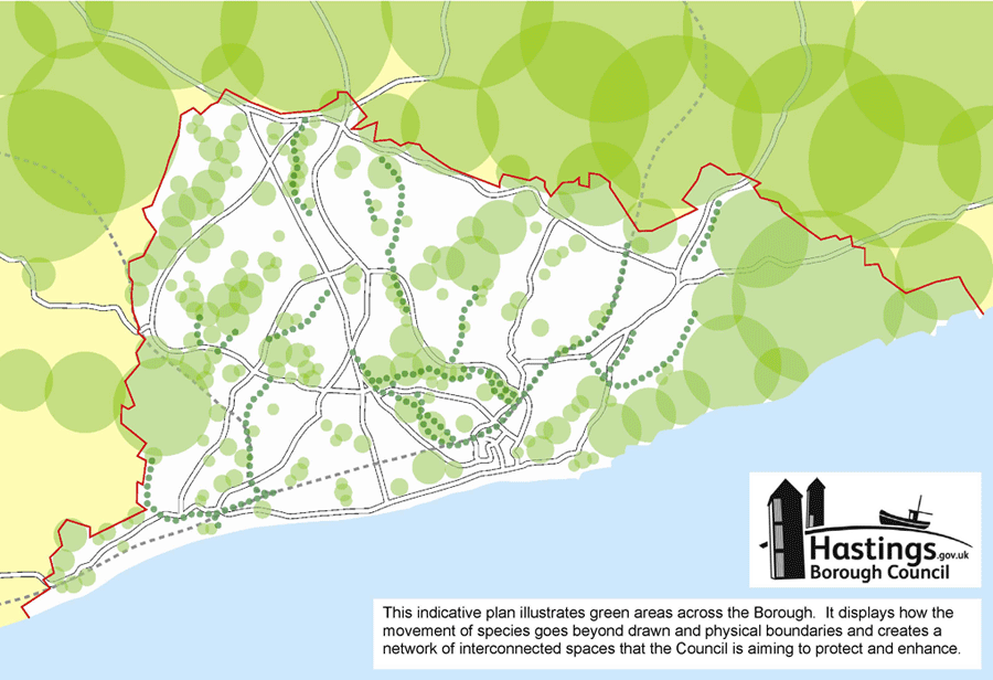
Figure 10: Indicative plan of green areas
(Click on the image to enlarge it)7.11 The green infrastructure network will be delivered through:
-
financial contributions from developers (eventually as part of the proposed Community Infrastructure Levy should this be the approach adopted by the Council)
-
how the Council manages its own land
-
working with East Sussex County Council to provide footpaths and cycle ways across the town.
Biodiversity and the natural environment
7.12 The town boasts a European designated Special Area of Conservation (SAC) at Hastings Cliffs, 3 nationally designated Sites of Special Scientific Interest (SSSI) at Combe Haven Valley, Marline Valley and Hastings Cliffs to Pett Beach, 7 Local Nature Reserves (LNR) and 25 Local Wildlife Sites. These are the priority natural areas, and together with the coast, rivers, woods, streams, fields, parks and open spaces, are the assets that make up the natural fabric of the town.
7.13 We have a responsibility to ensure biodiversity is not lost and that the green infrastructure network is protected from development and, where possible, strengthened to provide the widest range of linked environmental and social benefits for the town, its wildlife and its citizens. In line with Government policy, we will move from net biodiversity loss to net gain, by supporting healthy, functioning ecosystems and coherent ecological networks.
7.14 All the wildlife sites and key open spaces in the town support a healthy functioning ecosystem that contributes to a better quality of life and to people’s sense of well-being. It is important this ecosystem is protected from development and where possible, strengthened as part of the wider green infrastructure network.
7.15 The Hastings Local Biodiversity Action Plan (BAP) identifies all of the town’s national priority habitats, including a description of the habitat and its location along with national targets and objectives relating to the habitat. The BAP shows that the majority of areas of high biodiversity importance in the town occur in the designated sites mentioned above. The Council’s BAP strategy is to enhance biodiversity by focusing on the management and protection of this green network of designated sites, which are in themselves ecologically diverse and contain priority species and habitats.
7.16 Biodiversity Opportunity Areas (BOAs) have been identified by Sussex Biodiversity Partnership at Combe Haven and Marline Valley, Hastings Fringe and Romney Marsh (includes Hastings Country Park). These are part of a Sussex wide network of BOAs and identify where the greatest opportunities for habitat creation and restoration lie.
7.17 Further information on these BOAs is available from the Sussex Biodiversity Partnership website at www.biodiversitysussex.org/publications/biodiversity-opportunity-areas
(2) POLICY EN3: Nature Conservation and Improvement of Biodiversity
The town’s biodiversity and geological resources will be protected and enhanced. Priority will be given to:
-
protecting, managing and enhancing the Hastings Cliffs Special Area of Conservation, and other protected biodiversity and geodiversity sites and features including Sites of Special Scientific Interest, Local Nature Reserves and Local Wildlife Sites around the town
-
ensuring development contribute to the national objective of no net loss of biodiversity by requiring developers to show how their proposals will contribute positively to the natural environment, avoid harm to biodiversity, adequately mitigate for unavoidable damage, or as a last resort, compensate for unavoidable damage.
-
ensuring proposals for development comply with national and local planning policies relating to biodiversity, and with national Standing Advice published by Natural England.
-
improving the integrity and biodiversity of the green infrastructure network,
-
minimising potential negative impacts of new development on the Hastings Cliffs Special Area of Conservation through the delivery of new greenspace across the Borough and through appropriate recreation management of Hastings Country Park and other key natural green spaces around the town
-
meet our obligations to halting the loss of biodiversity and work with our partners to create opportunities for enhancing biodiversity both in and outside the town
-
protecting woodland, particularly ancient woodland and veteran trees
-
strengthening populations of protected and target species
-
improving site management and increasing public access to areas of nature conservation importance
-
influencing and applying agri-environment schemes, woodland grant schemes, flood defence and other land management practices to deliver biodiversity targets
Potential adverse effects on the Hastings Cliffs Special Area of Conservation arising from levels of new development set out in the Planning Strategy will be mitigated through improvements to the existing Broomgrove Local Wildlife Site, Combe Valley Countryside Park and the green spaces network as a whole.
7.18 Recreational activity within the Hastings Country Park will continue to be managed to avoid adverse effects on the Special Area of Conservation as a result of any increased recreational demand. Enhanced measures will be introduced if and when necessary, to ensure continued avoidance of adverse effects. Collectively, these measures will spread the recreational load and ensure adverse effects on the Special Area of Conservation will be avoided.
7.19 The details of these measures are set out in the Appropriate Assessment of The Hastings Planning Strategy (May 2010), and Update in March 2012 available at www.hastings.gov.uk/localplan/resources.aspx
7.20 Further information on Ancient Woodland is also set out in background document “Ancient Woodland Inventory of Hastings” (2010), available on the our website at www.hastings.gov.uk/environment_planning/planning/local_development_framework/evidence_base/
Conservation and enhancement of landscape
7.21 The overall strategic approach to landscape protection will support the action priorities as far as possible, for the Come Haven Valley and High Weald Coast Landscape Character Areas, as set out in East Sussex County Council’s Landscape Character Assessment. Of particular significance to the town, is the High Weald Area of Outstanding Natural Beauty (AONB), which is a key asset of Hastings’ landscape and the surrounding areas. It runs from East Grinstead and Tunbridge Wells in the north, down to Hastings and Rye on the Coast.
7.22 The AONB is designated for its rolling hills, small, irregular fields, abundant woods and hedges, scattered farmsteads and sunken lanes. The protection of these special quality landscapes is becoming increasingly important, particularly given increasing pressure for development to support the town’s regeneration.
(1) 7.23 Potential for joint urban fringe management with Rother District Council exists in particular in the area to the north of Hastings, with Rock Lane to the east and Ivyhouse Lane to the west. The area lies within the AONB and could be improved to provide a valuable amenity for the surrounding areas.
7.24 The overall strategic approach to landscape protection will be supported by further detailed policies in the Development Management Plan. The following policy will be implemented through decisions on planning applications and the land management practices of the Council and its partners.
(2) POLICY EN4: Conservation and Enhancement of Landscape
The Council will protect and enhance the town’s landscape including:
-
the distinctive landscape setting of the town, particularly the structure of ancient gill woodlands, open spaces and the relationship and clear division between the unspoilt coastline of Hastings Country Park Nature Reserve, the surrounding countryside and the built-up area
-
the High Weald Area of Outstanding Natural Beauty
-
the undeveloped coast
The Council will have regard to the High Weald Area of Outstanding Natural Beauty Management Plan 2004 as a method of protecting and enhancing the Area of Outstanding Natural Beauty, and will work with Rother District Council to improve access to and management of urban fringe areas, in line with the shared vision for Hastings and Bexhill.
Open spaces
7.25 We need to make best use of our open spaces to promote healthy recreation, community safety, accessibility, urban regeneration and adaptation to climate change.
(2) 7.26 The 2006 Parks and Open Spaces Strategy specifies that the focus for the future will be to improve the quality and value of existing open spaces, rather than establish new ones.
(5) POLICY EN5: Open Spaces – Enhancement, Provision and Protection
The strategic policy direction for the provision and management of the town’s open spaces is set out in the Parks and Open Spaces Strategy (2006). The Planning Strategy supports implementation of the Parks and Open Spaces Strategy by:
-
the progressive enhancement of existing open space provision rather than the creation of new provision, with priority for sites within or adjacent to the most deprived neighbourhoods. The development process will be one means of funding this enhancement through the pro-active use of planning agreements. However, where major new development is proposed in areas with no access to open space, the Council will ensure demand generated by the development is met through new provision.
-
the Development Management Plan will identify development sites where the provision of new, or enhancement of existing open space will be required. The open space contribution from ‘windfall’ development sites will be assessed in relation to need identified through the open spaces audit of 2006 and its subsequent updates. All provision will need to be in accordance with the Council’s Quality Standard for Open Spaces.
-
the protection and enhancement of existing open spaces that are of town wide significance through the green infrastructure network (see Policy EN2). These are: Alexandra Park, BOS Field, Church Wood, Gensing Gardens, Hastings Cemetery, Hastings Country Park, Old Roar Gill (part of Alexandra Park), Ponds Wood, St Leonards Gardens, St Helen’s Wood, Warrior Square, West Hill, Ore Valley, Summerfields Woods, Tilekiln Playing Fields, Combe Valley Countryside Park, all pedestrian-only streets, the Seafront, Bexhill Road recreation ground, Horntye Park, William Parker Sports College, Sandhurst Recreation Ground and the beach.
Private open spaces and allotments will be identified in the Development Management Plan as part of the green spaces network and will be protected from development which would lead to loss of their open character, biodiversity or accessibility.
Open space provision will be monitored in line with the Natural England Accessible Natural Greenspace (ANGst) standards, and results will be published each year in the Annual Monitoring Report.
23 South East Coastal Group website at www.se-coastalgroup.org.uk