
Hastings Planning Strategy Proposed Submission Version
Chapter 5: Spatial Areas
i) Western Area
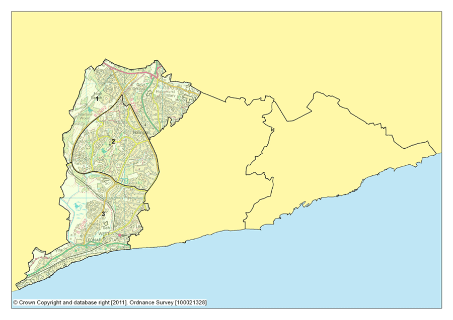
Figure 6: map showing Western Area
(Click on the image to enlarge it)An Introduction to Western Area
5.1 Western Area comprises the planning focus areas of Little Ridge & Ashdown; Greater Hollington and Filsham & Bulverhythe.
5.2 It covers the western side of the town, and encompasses a mix of housing, employment and green space areas. There is a diverse mix of people in the area with some well established communities and residential neighbourhoods.
5.3 Western Area has 4 out of the 6 major existing employment areas in the town, with a strong emphasis on manufacturing and engineering. There are several major supermarkets, the Conquest Hospital and Ashdown House, which are significant sources of employment for the town.
5.4 The total Western Area population is 27,700 (Mid 2009 population estimates, ONS), with the highest proportion of residents (23.5%) falling in the 45-64 (male) and 45-59 (female) age categories.
5.5 Data from the 2011 Index of Multiple Deprivation shows that Little Ridge and Ashdown is the least deprived Planning Focus Area in Western Area, and the town as a whole. Greater Hollington however, ranks as the 4th overall most deprived focus area in Hastings, and is the 2nd most deprived in terms of education, skills and training. Filsham and Bulverhythe rank 11th overall, 2 below Little Ridge and Ashdown. 8.6% of households in Western Area are in fuel poverty.
5.6 The new Hastings & St Leonards Academies opened in the existing school buildings in September 2011. Building works on the new St Leonards Academy will then be undertaken on the Filsham Valley site, and will be completed by September 2012. Part of the Grosvenor Gardens conservation area falls within Western Area.
Strategy for Western Area
5.7 The strategy for Western Area is to focus on its potential for employment and housing development, whilst protecting and enhancing existing areas of greenspace.
(1) 5.8 We will identify key seafront development sites at West Marina and Bulverhythe and maximise the potential for sustainable building in the area through linkages with existing areas of high heat demand at the Conquest Hospital, and by exploring opportunities for renewable energy schemes in Combe Valley Countryside Park.
5.9 Between 1,100 and 1,290 new homes, and approximately 36,700m² of employment floorspace will be provided in Western Area up to 2028, in accordance with Policy FA1 below. The range of dwelling numbers provided, give a broad indication of the number of new homes that are deliverable in the Plan period, for each of the Planning Focus Areas in Western Area.
The Bexhill - Hastings Link Road
5.10 The Bexhill – Hastings Link Road is proposed to enter Hastings at Queensway, within Western Area. Further detail on its implementation and importance to the Planning Strategy is set out in chapter 11.
Employment opportunities
5.11 The Queensway Employment Corridor is a core area of employment development opportunities located adjacent to Queensway. The aim here is to attract companies from around the UK and Europe, and growing the environmental technologies and services sector, as well as others who place importance on environmentally sustainable business. The Queensway Employment corridor involves the development of two key sites in Hastings, one of which is partially complete with some units let as at 2011.
5.12 In addition to new employment floorspace, it is important that we focus on reinvesting in, and making the most out of the existing employment areas of Castleham, Churchfields and Ponswood, as well as the smaller employment areas at West Ridge and Whitworth Road.
5.13 Development and redevelopment of these areas will include reducing carbon emissions and facilitating good environmental management, which will cover energy, transport, water, habitat and waste impacts. This will draw on an existing pilot low-carbon renovation project on a Council owned site on Castleham estate.
Combe Valley Countryside Park
5.14 The park is being developed and managed through joint working between Hastings Borough Council, Rother District Council and East Sussex County Council. The Countryside Park covers approximately 600 hectares and will conserve and enhance the green space between Hastings and Bexhill and strengthen the connections between the two towns. It includes the Pebsham landfill site, the fields at Glyne Gap, the Combe Haven Valley Site of Special Scientific Interest and the coast at Glyne Gap.
(1) 5.15 The vision for the park is to “create and manage a high quality sustainable, attractive and accessible multifunctional countryside area to serve the recreational and economic needs of residents and visitors”. The space will be used for leisure, relaxation, sport, ecology and education. The park will provide access to the countryside, whilst balancing the need to proactively manage wildlife habitats.
5.16 The current plans envisage an activity park in the vicinity of the landfill site, a coastal park to its south, a wetland wildlife area to the north and an environmental educational centre to the north east.
5.17 The countryside park will help to meet a county-wide open space deficiency within the locality as identified within the East Sussex Open Spaces Strategy and serving an urban population of 130,000 people, is fundamental in achieving the shared approach to regeneration for Bexhill and Hastings. It will also be an important part of the green infrastructure network, providing linkages to the rural areas surrounding Hastings, (see Policy EN2).
5.18 A Development Strategy and Implementation Plan 2011 - 2014 for the park has been approved by Hastings, Rother and East Sussex Councils. This will be regularly updated and revised to guide how the park changes and develops up to 2028.
Environmental opportunities
5.19 The Hastings Renewable and Low Carbon Energy Study (2009) has shown some potential for wind energy at Combe Valley Countryside Park (in both the Hastings and Rother areas). We will work with Rother District Council to explore this opportunity further, and identify the potential for renewable energy provision to offset the town’s carbon emissions resulting from implementation of the whole development strategy for the town.
5.20 Through heat mapping, the Conquest Hospital has been identified as an area of high heat demand. This presents potential for the introduction of Combined Heat and Power (CHP) systems and district heating networks into the existing building stock.
5.21 Some of the most significant wildlife habitats in the town are located within Western Area; the ancient woodland SSSI of the Marline Valley, Filsham Reedbeds LNR and the Combe Haven SSSI and the ancient woodland LNR of Churchwood. These lie adjacent to the wider countryside and the High Weald AONB, providing links to the wider countryside and habitat and species diversity.
5.22 It is important for us to continue to work with key partners to improve the quality of current wildlife sites by better habitat management; increasing the size of existing wildlife habitats; enhancing connections between sites and creating new sites where we can, using the green infrastructure network and therefore reducing the pressure on wildlife by improving the wider environment.
(1) 5.23 Flooding is a key issue within parts of Western Area, although the area does benefit from sea defences to protect against tidal flooding. Flood zones 2 and 3 encompass areas at Glyne Gap, Bulverhythe Recreation Grounds, along Combe Haven between Pebsham and the Combe Haven Holiday Park, the Combe Haven Valley, to the South of Bulverhythe Road to Cinque Ports Way and along parts of the Hollington Stream, particularly at Harley Shute playing fields. Development in these areas will need to demonstrate how flood risk has been addressed in accordance with Policy SC7, through the application of the sequential and exception tests where necessary, and the submission of detailed flood risk assessments.
(6) POLICY FA1: Strategic Policy for Western Area
The following table sets out the overall indicative quantity of development for Western Area, which will be explored in further detail in the Development Management Plan.
| Planning Focus Area | Housing – range of dwellings by area up to 2028 |
Employment – m2 of additional (net) employment land up to 2028 |
Retail - m2 of additional (net) retail comparison floorspace up to 2028 |
|---|---|---|---|
| 1. Little Ridge and Ashdown | 220 - 280 | Mixed B1, B2, B8 – c.23,400m² (at Queensway & Whitworth Road) | 0m² |
| 2. Greater Hollington | 250 - 310 | Mixed B1, B2, B8 c.13,300m² (at Churchfields, Castleham & Ponswood Industrial Estates) | 0m² |
| 3. Filsham Valley and Bulverhythe | 630 - 700 | 0m² | 0m² |
| Total | 1,100 - 1,290 | 36,700m² | 0m² |
Table 3: The indicative quantity of development for Western Area
In Western Area, we will also:
-
ensure development along the Queensway Employment Corridor meets high standards of environmental sustainability within what is practical and economically viable
-
support the development of land at West Marina for a mix of housing and leisure uses
-
encourage the retention of existing, and provision of more high quality visitor accommodation along the Seafront, the main arterial routes, and close to other generators of demand
-
be less strict in retaining premises in their existing land use (as defined by the relevant Land Use Classes Order) providing a sound employment based case can be made to secure employment development at Ponswood, Churchfields, Castleham and West Ridge
-
support research and development facilities aligned to the needs of local industries as well as further improvements to the town’s educational infrastructure
-
support the delivery of the proposed Bexhill-Hastings Link Road and A21 Baldslow Link improvements, and work to secure their timely provision.
-
work with Rother District Council and East Sussex County Council to establish and manage Combe Valley Countryside Park as a sustainable multi-functional countryside area with recreation, biodiversity conservation and regeneration opportunities, and support its development in line with the Park Development Strategy and Implementation Plan
-
work with Rother District Council to explore renewable energy opportunities in Combe Valley Countryside Park to meet the town’s long term energy needs
-
protect, manage and enhance the green spaces network, in particular, the Marline Valley Woods and Combe Haven Sites of Special Scientific Interest, the Filsham Reedbeds, Marline Valley Woods and Churchwood Local Nature Reserves and significant open spaces at Church Wood, Ponds Wood, Bexhill Recreation Ground and the Seafront
-
support the implementation of the strategic network of cycle routes to link communities and facilities, particularly from the Conquest Hospital down towards Hastings Town Centre and out to Combe Valley Countryside Park
-
direct development to areas at the lowest risk of flooding, and require site specific Flood Risk Assessments to be provided for development in areas at a higher risk as identified in the Strategic Flood Risk Assessment - in the vicinity of Bulverhythe and West Marina and the Combe Haven River, Stonehouse Drive, Upper Glen Road Hollington Old Lane and Gillsmans Hill
-
explore opportunities for combined heat and power (CHP) connected to district heating systems or combined cooling, heat and power (CCHP) for development proposals within the vicinity of the Conquest Hospital
-
support the opening and development of the St Leonards Academy at Filsham Valley school site
ii) Central Area

Figure 7: map showing the central area
(Click on the image to enlarge it)An Introduction to Central Area
5.24 Central Area comprises the planning focus areas of St Helens, Silverhill and Alexandra Park, Maze Hill and Burtons’ St Leonards, Central St Leonards and Bohemia, Hastings Town Centre and West Hill. It the most densely populated spatial area, with 43,801 residents, and has the lowest proportion of 0-15 year olds in the town, at just 17.6% (ONS Mid 2009 population estimates).
5.25 Each area has its own unique identity, ranging from the active Town Centre with over 500 retail units and predominantly privately owned or private rented housing, to the expansive Alexandra Park, surrounded by large Victorian properties. Silverhill provides local shops and small businesses that are popular with local residents, as well as an Asda supermarket, whilst St Helens is predominantly residential, with a high proportion of privately owned properties.
5.26 Central Area contains 15 out of the 18 Conservation areas in the town. Data from the 2011 Index of Multiple Deprivation shows that Central St Leonards and Bohemia and Hastings Town Centre are the most deprived planning focus areas in Central Area, ranking 2nd and 3rd in Hastings as a whole. Conversely, St Helens is one of the least deprived planning focus areas, highlighting the diversity of this spatial area.
5.27 Central St Leonards and Bohemia and Hastings Town Centre are also the most deprived areas in Hastings in terms of fuel poverty, with 17.3% of households in the Town Centre in fuel poverty, and 17.6% in Central St Leonards and Bohemia.
(1) 5.28 A significant amount of regeneration funding has been focused in the town centre in recognition of these issues, particularly in terms of improving the education offer at the University Centre Hastings and the new Sussex Coast College. In addition, the new office and retail developments at Priory Quarter will ensure the quality of space available is improved, and contribute positively to the local economy.
5.29 Taken together, all these developments will work towards maintaining and improving the vitality and viability of Hastings town centre, for the benefit of the town as a whole. Hastings town centre will continue to be a focus for change and growth; along with infill and extension opportunities at some of the town’s existing employment estates.
Strategic policy for Central Area
(2) 5.30 Major developments and improvements planned in the town centre form the focus for change in Central Area, although tourism, flooding, open space and housing are also key considerations for the area as a whole. It will also be important to support educational growth and associated facilities, including accommodation for students and the evening and night time economy.
(1) 5.31 The focus on regeneration in Central St Leonards and the wider South St Leonards area will continue, particularly in terms of housing mix and tenure in Central St Leonards. We will also continue to support Central St Leonards and Silverhill as district centres, and introduce management measures to retain and focus the function of Bohemia as a local shopping centre.
5.32 Between 1,220 and 1,500 new homes, 21,700m² of employment floorspace, and approximately 20,500m² of comparison goods retail floorspace will be provided in Central Area up to 2028, in accordance with Policy FA2 below. Table 4 gives a broad indication of the potential number of new homes that are deliverable by 2028, for each of the Planning Focus Areas in Central Area.
Environmental opportunities
5.33 Through heat mapping, Hastings Town Centre and Summerfields Sports Centre have both been identified as areas of high heat demand. This presents potential for the introduction of Combined Heat and Power (CHP) systems and district heating networks into the existing building stock, particularly alongside any large scale new retail development in the case of Hastings Town Centre.
(1) 5.34 Given that Central Area is the most densely populated of the 3 spatial areas, it is essential that communities within have access to good quality open space. Despite its urban nature, the town as a whole does have a surprising wealth of good quality open spaces and nature reserves, which we need to enhance and develop, to help the connections between human well being and the natural environment. Key parks and open spaces in Central Area include St Helens Woods Local Nature Reserve, Summerfields Woods Local Nature Reserve and the national heritage awarded park, Alexandra Park.
5.35 Our commitment is to ensure that we properly value nature and open spaces by safeguarding and managing them, to enhance their wildlife value and encourage access for all sectors of the community.
Cultural opportunities
5.36 There is significant potential for building on the existing cultural offer in both St Leonards and Hastings town centres. The Hastings Cultural Regeneration Strategy, specifically looks to developing cultural quarters in Central St Leonards built around studio and workshop space for the creative industries, and in Hastings Town Centre from the White Rock to Station Plaza. It will be important to support creative businesses in this area, encouraging the take up of empty units for studios and workshops in these locations where appropriate.
(6) POLICY FA2: Strategic Policy for Central Area
The following table sets out the overall indicative quantity of development for Central Area, which will be explored in further detail in the Development Management Plan.
| Planning Focus Area | Housing – range of dwellings by area up to 2028 | Employment – m2 of additional (net) employment land up to 2028 |
Retail - m2 of additional (net) retail comparison floorspace up to 2028 |
|---|---|---|---|
| St Helens | 210 - 250 | 0m² | 0m² |
| Silverhill and Alexandra Park | 300 - 360 | 0m² | 0m² |
| Maze Hill and Burtons St Leonards | 220 - 280 | 0m² | 0m² |
| Central St Leonards and Bohemia | 240 - 300 | 0m² | A modest quantity of retail development would be supported in Central St Leonards compatible with function as a district centre |
| Hastings Town Centre | 200 - 240 | B1(a) – Approx. 21,700m² (the remaining phases of the Priory Quarter) | Up to 20,500m² of comparison retail space in town centre |
| West Hill | 50 - 70 | 0m² | 0m² |
| Total | 1,220 - 1,500 | 21,700m² |
Up to 20,500m² Note: Any retail development
in Central St Leonards or elsewhere would contribute to the meeting of the identified need of 20,500m² |
Table 4: The indicative quantity of development for Central Area
In Central Area, we will also:
-
support further delivery of regeneration and change in the town centre by 2028
-
support research and development facilities aligned to the needs of local industries as well as further improvements to the town’s educational infrastructure
-
protect and enhance Central St Leonards and Silverhill as District Centres
-
focus on improving the physical environment, the quality and mix of housing and the local economy in Central St Leonards
-
consider the rationalisation of the primary retail area, to protect the function of Bohemia as a local shopping centre.
-
explore opportunities for Combined Heat and Power connected to District Heating systems in the vicinity of the Summerfields Sports Centre
-
support the implementation of the strategic network of cycle routes from the town centre out to strategic open spaces, the seafront, nature conservation areas and community facilities as identified on the Key Diagram
-
protect, manage and enhance the green spaces network, in particular, the Local Nature Reserves at Old Roar Gill and Summerfields Woods and other significant open spaces at Alexandra Park, Old Roar Gill, BOS Field, St Helens Wood, West Hill, Summerfields Woods, pedestrian only streets in the town centre, the Seafront, William Parker Sports College, Sandhurst recreation ground, Gensing Gardens, St Leonards Gardens, Warrior Square and Horntye Park
-
ensure all developments take account of past flooding and the impact of anticipated future climate changes on flooding in the Town Centre. Aim to reduce the overall level of flood risk in the area through the layout and form of the development, improvements to local defences and the application of suitable sustainable drainage systems.
-
encourage the retention of existing, and provision of more high quality visitor accommodation along the Seafront, the main arterial routs, and close to other generators of demand
-
protect and enhance architectural heritage, particularly in the conservation areas
-
encourage mixed use developments and explore the potential for ‘living above the shop’
-
support densities of at least 40 dwellings per hectare in Hastings Town Centre, and Central St Leonards and Silverhill district centres
Hastings Town Centre
5.37 The Hastings & Bexhill Task Force developments over recent years have already made Hastings Town Centre more vibrant, and we now need to make sure this is taken forward in the longer term. It is important to maintain and improve the role of the town centre as a pleasant, lively and safe place for shopping, recreation, education, employment, and as a place to live, as well as developing the evening economy.
5.38 The town centre will remain a focus for education and employment, and the centre’s role as a sub-regional shopping centre will be enhanced through the development of an additional 20,500m2 of comparison goods floorspace to meet projected retail needs (see Policy FA3).
(1) 5.39 We will also encourage the development of cultural quarters in Hastings town centre from the White Rock Theatre to Station Plaza, by encouraging the re-use of empty units for studio purposes where appropriate.
(1) POLICY FA3: Strategy for Hastings Town Centre
In Hastings Town Centre we will:
-
provide for approximately c.21,700m2 (net) employment floorspace at Priory Quarter by 2028
-
provide for 20,500m2 (gross/net) retail comparison goods floorspace up to 2028
-
achieve a more even mix of housing tenure
-
promote competitiveness in terms of the range and type of shops operating in the area
-
ensure the area is attractive to visitors and support the retention of visitor accommodation
-
promote accessibility by local public transport, walking and cycling, and for people with disabilities
-
develop the evening economy
-
promote and encourage improvements to the public realm as part of new development schemes and in day to day repairs and maintenance
-
promote leisure and cultural facilities including the redevelopment of the library, and support the development of cultural quarters between White Rock & the America Ground and Station Plaza through the Development Management Plan
-
protect and enhance architectural heritage, particularly in the conservation area
-
maintain the distinctiveness of the area in terms of architecture, townscape and function
-
improve the existing housing stock and quality of life for residents
-
encourage mixed use developments and explore the potential for ‘living above the shop’
-
seek to reduce the number of long term empty homes
-
control the distribution and mix of Houses in Multiple Occupation within the area
Central St Leonards
5.40 Central St Leonards presents a complex mix of social, environmental and economic challenges. It has some of the highest unemployment levels and lowest household incomes in the town. At October 2011 12.1% of the resident population between 16 – 64 were claiming Job Seekers Allowance compared to 7.7% for the town as a whole (NOMIS). Also, in 2011 average household mean income within the area was £25,448 in comparison to £30,715 for the town as a whole (source: CACI, 2011).
5.41 In recognition of this Central St Leonards remains a priority regeneration area for the Council. We are focusing on key physical, social and economic interventions to bring about a ‘step change’ in the area, and aim to change peoples’ perception of Central St Leonards, to achieve long-term economic growth, inward investment and a better quality of life for the local community.
5.42 Central St Leonards has a large proportion of privately rented dwellings and houses in multiple occupation, many of which are well below modern standards. This is partly a reflection of the age and type of the housing stock. There is a predominance of large Victorian properties, which have been converted to multi-occupancy. It is important that we encourage larger family units in Central St Leonards to ensure a better mix of dwelling sizes and tenure, and help to encourage a more permanent, less transient local population in Central St Leonards.
5.43 The area was declared a Housing Renewal Area in 2003 which lead to some significant improvements. In addition Hastings Borough Council has recently commenced a housing-led regeneration programme called the Coastal Space Project St Leonards. This is a £3.5m funded joint initiative between Hastings Borough Council and Local Space, with the support of East Sussex County Council, the Homes and Communities Agency, and AmicusHorizon. It is one of a number of projects which aims to improve housing conditions and associated social and economic problems in the area.
(1) 5.44 Central St Leonards is a place that is positively changing. The area has many independent retailers and has attracted a number of new businesses over the past few years, thereby drawing new residents and visitors to the town. Central St Leonards serves an important role as a district shopping centre, and we need to take a flexible approach in terms of the different types of uses we allow, whilst ensuring its function as a local centre is not compromised. A positive attitude to the development and use of existing commercial and employment spaces is also essential in order to provide opportunities for local entrepreneurship and skills training. It is important that a range of business premises is available, including affordable and managed space for small businesses and start-ups. Detailed management policies regarding the retail centre will be further examined in the Development Management Plan.
(3) POLICY FA4: Strategy for Central St Leonards
In Central St Leonards, we will:
-
support the development of key sites in Central St Leonards, including the former Hastings College site in Archery Road, the Coastal Space Project, Alpha Café site and Crystal Square, to be taken forward as opportunities arise.
-
maintain and enhance the area’s role as a District shopping centre through the protection of a retail core – to be identified in the Development Management Plan
-
support the retention, development and conversion of properties for training and small business, community uses, arts and cultural sector, supporting the development of a cultural quarter in Central St Leonards through the Development Management Plan.
-
support positive proposals for activities on the St Leonards seafront including Bottle Alley, Warrior Square promenade, West St Leonards (bathing pool site) and other parts of the seafront
-
continue to concentrate resources on improving housing conditions and reducing the number of empty dwellings in the area
-
seek to achieve a better mix of housing by encouraging the provision of larger dwellings (2 or more bedrooms), and supporting innovative housing schemes that will help to improve the perception of the area
-
encourage the building of a range of different sized housing units by introducing a planning policy in the Development Management Plan that requires all residential development, including conversions and changes of use, to provide a mix of dwelling unit sizes within single developments (rather than being limited to a mix of 1 and 2 bed units).
-
work with the Homes and Communities Agency and Housing Associations to achieve greater levels of housing choice in the area by promoting more affordable housing
-
grant planning permission for suitable proposals that tackle key buildings that are in need of repair. A flexible approach to their future use will be adopted if this assists in securing their future viability.
-
ensure that development proposals and improvements to the existing housing stock take into account the historic character of the area
-
seek to reduce the number of long term empty homes
-
control the distribution and mix of Houses in Multiple Occupation within the area
-
promote and encourage sustainable modes of transport, specifically through the improvement of pedestrian and cycle routes
iii) Eastern Area
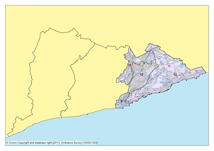
Figure 8: map showing the eastern area
(Click on the image to enlarge it)An Introduction to Eastern Area
5.45 Eastern Area is made up of the Old Town, Hillcrest and Ore Valley, Clive Vale and Ore Village and Hastings Country Park. 15,454 people live in Eastern Area (ONS, mid 2009 population estimates, and it has the highest proportion of young people when compared to the rest of the town – 21.5% in the 0-15 age category, and 17.3% in 16-29 age category.
5.46 This is one of the most diverse areas in the town. In addition to residential areas like Halton, Clive Vale, West Hill and the Pilot Road area, Eastern Area also offers the attractions of the Old Town and the Stade, Hastings Country Park Nature Reserve, and Hastings Cliffs Special Area of Conservation, and business accommodation at the Ivyhouse Lane employment area.
5.47 The expansive Old Town Conservation area falls within Eastern Area, along with the Tillington Terrace Conservation area further north.
5.48 Data from the 2011 Index of Multiple Deprivation shows that the Hillcrest and Ore Valley Planning Focus Area is the most deprived in Hastings overall. The Old Town is the 7th most deprived overall, but 11th out of 13 for the education domain.
5.49 Work is ongoing to regenerate this area and tackle deprivation. In recent years 2 major schemes have been brought forward - The Stade improvement scheme, which includes the Stade Hall, seafood training kitchen, high quality café and open air event space, in addition to the Jerwood Gallery itself, and the Sussex Coast College site in Parker Road. The new Hastings & St Leonards Academies opened in the existing school buildings in September 2011, which will follow with building works being completed for the new Hastings Academy on the Hillcrest site, by September 2012.
Strategy for Eastern Area
5.50 The strategy for Eastern Area is to continue regeneration efforts on the Ore Valley Development sites at Ore Valley and the wider area, and secure a sustainable future for the area. Managing and mitigating recreational pressure from new development in the area on the Hastings Cliffs Special Area of Conservation will be a significant part of this strategy.
5.51 In addition, it is important to improve the vitality and viability of Ore as a District Centre and Old Town as a local centre, and support the development of the Hastings Academy on the Hillcrest school site.
5.52 Between 740 – 920 new homes and 12,200m² of employment floorspace will be provided in Eastern Area up to 2028, in accordance with Policy FA5 below. Table 5 below gives a broad indication of the potential number of new homes that are deliverable in the Plan period, for each of the Planning Focus Areas in Eastern Area.
Hastings Old Town
5.53 Hastings Old Town is historically and architecturally a valuable part of the town and, also very popular as a tourist attraction - through both the unique shopping offer, and the leisure activities available on the Seafront and at the Stade. Businesses also serve the local community and this balance gives year round life and vitality to the area.
5.54 It is therefore important to build on this tourism and cultural offer, and ensure that the area continues to function strongly as a local shopping centre, protecting its unique architectural heritage.
Environmental opportunities
5.55 The Hastings Renewable and Low Carbon Energy Study (2009)15 has shown some potential for wind energy in a small area of Hastings Country Park. We will explore the potential for a further turbine in this area to help offset the carbon emissions resulting from implementation of the whole development strategy for the town.
(1) 5.56 There is also potential for a joint urban fringe management approach to the north of the town, approaching The Ridge, with Rock Lane to the east and Ivyhouse Lane to the west with Rother District Council. The area lies within the High Weald AONB, but its quality and accessibility could be improved to provide a valuable amenity for residents in both areas.
5.57 The eastern area of the town has the most significant wildlife areas in terms of international importance and designation. Hastings Country Park Nature Reserve is the largest area of publicly accessible natural habitat in the town, and forms the gateway to the High Weald. The spectacular countryside and diverse range of habitats and species mean that the Nature Reserve is one of our prime visitor attractions. However, it also provides out of season opportunities that are currently under utilised.
5.58 It is important for us to continue to work with key partners to improve the quality of current wildlife sites by better habitat management; increase the size of existing wildlife habitats; enhancing connections between sites and create new sites where we can, using the green infrastructure network and therefore reducing the pressure on wildlife by improving the wider environment.
(6) POLICY FA5: Strategic Policy for Eastern Area
The following table sets out the overall indicative quantity of development for Eastern Area, which will be explored in further detail in the Development Management Plan.
| Planning Focus Area | Housing – range of dwellings by area up to 2028 |
Employment – m2 of additional (net) employment land up to 2028 |
Retail - m2 of additional (net) retail comparison floorspace up to 2028 |
|---|---|---|---|
| Old Town | 50 - 70 | 0m² | 0m² |
| Hillcrest and Ore Valley | 440 - 540 |
Mixed B1, B2, B8 – approx 11,400m² (at Ivyhouse Lane Industrial Estate) |
0m² |
| Clive Vale and Ore Village | 250 - 310 | 0m2 | 0m² |
| Hastings Country Park | 0 | 0m² | 0m² |
| Total | 740 - 920 | 11,400m² | 0m² |
Table 5: The indicative quantity of development for Eastern Area
In Eastern Area we will also:
-
adopt a joined up approach with Rother District Council to the use and management of land between Ivyhouse Lane and Rock Lane, to secure environmental and access improvements in association with development in the locality
-
protect and enhance the Old Town as a local centre to better meet people’s day-to-day needs, and encourage the retention of traditional shops and shopping facilities in George Street and the High Street
-
maintain and enhance Ore Village as a District Centre and improve accessibility as far as possible
-
protect and maintain the unique townscape of Hastings Old Town, a visitor attraction in its own right
-
encourage the retention of existing, and provision of more high quality visitor accommodation along the Seafront, the main arterial routes, and close to other generators of demand
-
support research and development facilities aligned to the needs of local industries as well as further improvements to the town’s educational infrastructure
-
protect, manage and enhance the green network of nature areas and open spaces that include Hastings Country Park Nature Reserve and associated national and international designated wildlife areas such as Hastings Cliffs Special Area of Conservation and Hastings Cliffs to Pett Beach Site of Special Scientific Interest and other significant open spaces at the Ore Valley Development site, the Seafront, Hastings Cemetery, Hastings Country Park and West Hill
-
aim to achieve National Nature Reserve (NNR) status for the Hastings Country Park, as part of Council’s Biodiversity Action Plan, area by 2015
-
explore the potential for renewable energy opportunities in Hastings Country Park to meet the town’s long term energy needs
-
support the implementation of the strategic network of cycle routes that will link communities to the strategic open spaces, the seafront, nature conservation areas and community facilities, particularly along the Seafront and up to Ore Village
-
encourage local communities to access areas of open space
-
support the opening and development of the Hastings Academy at Hillcrest school site
-
support densities of at least 40 dwellings per hectare in the Old Town and Ore Village
iv) The Seafront
Figure 9: map showing the seafront
(Click on the image to enlarge it)An Introduction to the Seafront
(1) 5.59 The Seafront is very much the public face of the town and one of our prime assets. We need to plan change in the area to make more of economic, leisure and health opportunities associated with a seafront location, make the beach and promenade accessible to all sectors of the community and continue to encourage owners of seafront properties to invest in the upkeep and repair of their buildings to continue to improve the towns’ image.
Strategy for the Seafront
5.60 The strategy for the Seafront is to build on the existing tourism economy and continue to enhance the Seafront and public realm.
(1) 5.61 The Seafront Strategy was prepared under the direction of the Hastings & Bexhill Task Force, Tourism South East, Hastings Borough Council and Rother District Council in 2005. This is an economic strategy to regenerate Hastings and Bexhill by using the seafront as the area’s best asset. We will support the delivery of key projects and proposals taken from the Seafront Strategy through policies in this Plan and the Development Management Plan where necessary.
Tourism and the public realm
5.62 Recent years have seen significant improvement along the Seafront. The Marina Pavilion has now been restored, there have been improvements to the physical environment through the Council’s Grotbusters scheme, a multi-use games area and volleyball court have been installed along the promenade. The Jerwood Gallery and surrounding space and the extension to the National Cycle Network was completed in 2012.
5.63 The town also continues to host popular festivals, for example, Jack in the Green, Seafood & Wine, Hastings Old Town Carnival Week and Hastings Week throughout the year, attracting visitors from outside of the town.
5.64 Despite these improvements, it is still important for us to continue to focus on tourism and environmental improvements, taking account of the effects of climate change and rising sea levels. Expanding and maintaining an all year round tourist season is of great importance, and we need to ensure the correct types of accommodation and visitor attraction are available to support this. We need to retain and improve our existing visitor attractions and accommodation along the Seafront, and direct new visitor accommodation there too.
5.65 The Jerwood and associated Stade developments will help bring new visitors to the area, and are likely to raise expectations of the seaside environment. In the past, improvements to the public realm have tended to be ad hoc and dependent on new developments, so it is important for us to continue to obtain private and public investment, and promote public art to enhance and maintain the surroundings.
5.66 The development of Combe Valley Countryside Park and the extension of the National Cycleway Network, together with future development at West Marina, will also promote the importance of the Bulverhythe and West St Leonards areas as the western gateway to the town.
Environmental issues
5.67 Flood defences located along the Bulverhythe area of the coast are the responsibility of the Environment Agency. These were enhanced in 2006, and provide a 1 in 200 year standard of protection.
5.68 Coast Protection assets include seawalls, groynes and shingle banks are the responsibility of Hastings Borough Council. The South Foreland to Beachy Head Shoreline Management Plan states that the long term policy is to “hold the line” in providing protection for the frontage, which means that coastal defences in the town are likely to be maintained in good working order for the foreseeable future.
5.69 Over the past few years the Council has built a new rock groyne to prevent wave overtopping at Carlisle Parade and is carrying out a programme of groyne refurbishment.
5.70 Further investment will be required to maintain the existing standard of defence and to compensate for the effects of climate change (including sea level rise and an increase in intensity, severity and frequency of coastal storms). Planned investment includes the construction of additional rock groynes at Carlisle Parade, enhancement and repair of the Harbour Arm and eventual replacement of the existing timber groynes. In addition the Council will continue to recycle shingle that accumulates at the eastern end of the coastline to areas where it is eroded.
Cultural opportunities
(1) 5.71 Following the opening of new cultural venues at The Stade Open Space, Stade Hall and Jerwood Gallery, we need to ensure the best use is made of existing venues, particularly along the Seafront. We will encourage the development of cultural quarters at the Old Town and the Stade, making the most of the fishing industry, its museum and the Jerwood Gallery. In Central St Leonards a cultural quarter will be built around studio and workshop space for the creative industries; and in Hastings town centre, the area from the White Rock Theatre to Station Plaza will be identified as a cultural quarter.
(3) POLICY FA6: Strategic Policy for The Seafront
Along the Seafront, we will:
-
encourage the regeneration of key landmark sites along the seafront, from the Stade to West Marina, supporting development that builds on the Seafront’s distinctive heritage and attractiveness as a destination for leisure and recreational activity
-
take forward key projects and proposals in the Seafront Strategy to contribute to a co-ordinated plan for the Coastline in Hastings and Bexhill
-
implement the strategic network of cycle routes along the Seafront to connect with the strategic open spaces, nature conservation areas and community facilities in the rest of the town
-
support leisure and residential development to create an appealing destination at West Marina
-
continue to lobby and support the delivery of the Hastings to Bexhill Link Road to relieve congestion along the A259
-
support proposals for bringing the White Rock Baths building back in to use, or intermediate proposals for leisure at this site
-
encourage new visitor accommodation along the Seafront and in Hastings Town Centre
-
support a sustainable future for Hastings Pier
-
encourage the development of all year round tourist attractions to provide permanent jobs
-
install a seafront playground, other smaller play spaces, and a trail of fitness equipment at key locations
15 www.hastings.gov.uk/localplan/evidencebase