
Hastings Local Plan Pre-Submission Version 2023-2041 (Regulation 19) September 2026
6. Site Allocation Policies Comment
6.1To understand both housing need and potential land supply in Hastings, the Council is guided by a number of evidence and base studies including:
- Housing and Economic Development Needs Assessment Update 2026
- Strategic Housing and Employment Land Availability Assessment 2026
- Densification and Capacity Study Interim and Final Reports 2026
- Landscape Sensitivity to Residential, Commercial and Solar Development within Hastings 2024
- Strategic Flood Risk Assessment 2024
- Sustainability Appraisal 2026
Part one – Housing and Mixed-Use Allocations Comment
6.2Allocating a site in the Local Plan establishes the principle that the development of the site for housing is acceptable. However, the numbers set out in site allocation policies are indicative of what might be achieved. It is for the planning application process to determine the precise details of the development.
6.3The Local Plan must take need into account and provide for an adequate amount, quality, and type of housing in the appropriate places. Policy SP2 states that the Local Plan will make provision for the delivery of a minimum of 2,970 dwellings over the period 2023-2041 (165 net new dwellings per annum), of which 1,131 are allocated in the Plan.
6.4The housing allocations have been informed by the suitability, availability and deliverability assessment which forms part of the Strategic Housing and Employment Land Availability Assessment (SHELAA) process. The site allocations have also been informed by Sustainability Appraisal (SA) process to ensure that sustainable development is achieved in accordance with the NPPF.
6.5The plan allocations reflect a brownfield first approach to development, however given the significant land constraints within Hastings greenfield sites have been identified to help meet housing needs in the borough.
6.6The approach guiding residential housing site selection is therefore as follows:
6.7Sites that are suitable, available and achievable within the plan period are identified as site allocations. These sites are identified by the prefixes HSS and GT and are formal site allocations.
6.8Sites that are suitable and have the potential to be available and achievable within the plan period are identified as Regeneration Area Opportunity Sites. Areas that include these sites are identified by the prefix R and can be found in Section 5 of the Plan.
6.9The sites allocated under Policy HA1 are critical to achieving the objectives and strategy set out in Chapter 1. For larger sites, or where there are unique considerations, site specific policies are provided.
6.10 For smaller sites and Windfall sites, any subsequent planning application will be determined in accordance with the policies set out in this Local Plan.
6.11Appendix 2: Housing Trajectory shows when these housing allocations are expected to be delivered during the plan period, including in the first five years.
6.12Where site allocations identified within this plan are at risk of flooding, the council will ensure that sites are sequentially tested in line with National Planning Policy and Practice Guidance, and that the exception test is applied where necessary.
6.13The council is aware of the importance of monitoring the delivery of allocated sites in order to ensure housing needs are being met and in order to maintain a continuous five-year supply of deliverable sites. In accordance with the NPPF, the council shall annually identify and update a supply of specific deliverable sites, sufficient to meet its housing requirement for 5 years plus an additional buffer as applicable.
Marline Valley Woods SSSI and the Queensway Corridor
6.14All development in the Queensway Corridor has the potential to affect the SSSI. The Marline Valley Woods SSSI contains interest features which include a number of rare bryophytes within the SSSI’s steep-sided ghyll stream. The interest features of the SSSI rely on the continuation of the existing hydrological regime (the quality and quantity of water flowing from adjacent land to the SSSI). The SSSI is hydrologically linked to these locations.
6.15All applications in this location, whether in relation to sites allocated within this plan or as applications for sites yet to be identified, have the potential to affect the hydrogeology of the SSSI via impacts to the existing ground and surface water.
6.16Boreholes and trial pits in this area have shown it to be highly variable in nature with regard to the depth of the permeable layers and highly complex to develop. Applications must demonstrate that development will not impact the SSSI and that underlying sandstone layers will not be breached either by the finished development or during the construction phase.
Interpretation of Site Allocation Policies
6.17Site allocation policies should not be read in isolation. The Plan needs to be read as a whole in order to ascertain which policies will be relevant to individual sites or proposals. Local plans should not repeat National planning guidance or regulations or matters already addressed elsewhere within development plans. Therefore, where site allocation policies do not explicitly reference subject areas covered elsewhere within the development plan, it does not mean that these subject areas are not considered relevant. Where subject areas are specifically covered within site allocations it is because the are unique circumstances surrounding that site that should be taken into account when preparing planning applications in addition to the other policies of the plan.
Policy HA1: Applications for Housing and Mixed-Use proposals Comment
The Plan needs to be read as a whole in order to ascertain which policies will be relevant to individual sites or proposals. Proposals should, where appropriate, address the following non-site-specific material considerations within proposals for development:
- Design and character
- Heritage impacts
- Affordable housing
- Housing mix
- Residential amenity
- Transport, including sustainable and active travel
- Flood risk and sustainable drainage solutions (SuDS) for surface water management
- Contamination, nuisance and hazards including where the ‘agent of change’ principle applies
- Land stability
- Ecology and Green and Blue infrastructure
- Biodiversity Net Gain
- Arboriculture and landscape
- Open Space and Play Space
- Waste and recycling.
- Contributions and legal agreements
Residential development proposals must meet the requirements set out in strategic policy, including those that set out density and housing mix, unless specific site circumstances provide a clear justification for an alternative approach.
The following sites are identified on the Policies Map and are allocated for residential/or residential-led development, to deliver the housing land requirement set out in Policy SP2. The requirements set out in each allocation policy are specific to that site and should be considered in unison with the above non-site-specific material considerations. For specific requirements applicants should refer to the council’s validation checklist.
Specific Locational Requirements: Marline Valley Woods SSSI
Proposals for residential or mixed-use development adjacent to the Marline Valley Woods SSSI must be SuDS-led and maximise greenspace, avoid breaching the underlying sandstone layer and use borehole and/ or trial pit data to inform relevant groundwater assessments.
Figure 7: Density Zones within Hastings Borough
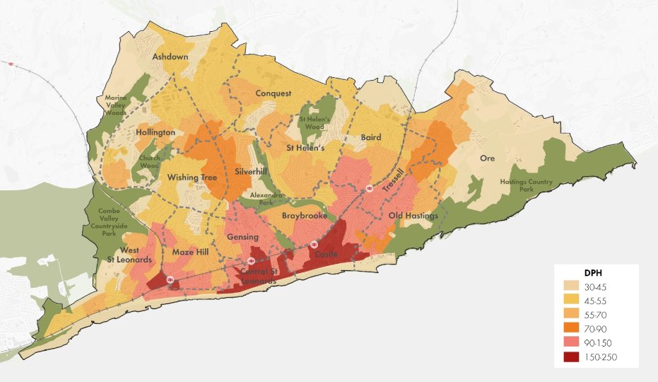
Table 8: Site capable of delivering 20 dwellings or more
|
Site Reference |
Site Address |
Site Area (ha) |
Use |
Indicative Capacity |
|
HS1 |
Land adjacent to Sandrock Park, The Ridge |
2.60 (net developable) |
Residential |
95 |
|
HS2 |
Seaside Road, West St Leonards |
2.22 |
Mixed use: residential, commercial and leisure |
120 |
|
HS3 |
Former Westerleigh School |
2.15 |
Residential |
100 |
|
HS5 |
Former West St Leonards Primary School, Bexhill Road |
0.8 (net developable) |
Residential |
50 |
|
HS6 |
Ore Valley (Former Power Station) |
2.36 |
Residential |
78 |
|
HS7 |
Former Post Office and University of Brighton building |
0.10 |
Mixed Use: Commercial and residential |
41 |
|
HS8 |
Mayfield E, Bodiam Drive |
1.06 |
Residential |
38 |
|
HS10 |
Land at Rock Lane |
1.2 |
Residential |
26 |
|
HS11 |
Cinque Ports Way |
0.37 |
Residential |
58 |
|
HS12 |
Gambier House, 111 West Hill Road and West House, 115 West Hill Road |
0.55 |
Residential |
20 |
|
HS13 |
Land North-West of Winchelsea Lane |
1.17 |
Residential |
20 |
|
HS18 |
Land at Tilekiln Farm |
4.33 (1/3 of site retained for open space) |
Residential |
75 |
|
HS20 |
Former West Hill Road Reservoir |
0.21 |
Residential |
30 |
|
HS21 |
Land East of Rock Lane |
0.72 |
Residential |
20 |
|
HS23 |
Land East of Beaneys Lane, The Ridge |
0.40 |
Residential |
18 |
|
HS25 |
Former Convent of Holy Child Jesus, Magdalen Road |
4.76 |
Residential |
200 |
|
HS26 |
Four Courts, Stonehouse Drive |
4.44 |
Gross capacity 450 net gain |
64 |
|
HS27 |
My Way Lodge, The Ridge West |
1.29 (1/2 of site retained as open space) |
Residential |
20 |
Table 9: Site capable of delivering fewer than 20 dwellings
|
Site Reference |
Site Address |
Site Area (ha) |
Use |
Indicative Capacity (Dwellings) |
|
HSS5 |
Land at Chiltern Drive |
0.20 |
Residential |
13 |
|
HSS8 |
Former Hollingsworth Garage, Braybrooke Road |
0.34 |
Residential |
9 |
|
HSS13 |
5 The Green |
0.11 |
Residential |
10 |
|
HSS14 |
Former Hillesden Mansions, 7-11 Chapel Park Road |
0.11 |
Residential |
15 |
|
HSS16 |
Mayfield Farm |
0.48 |
Residential |
11 |
|
Total allocated sites |
1,131 |
Table 10: Gypsy and Traveller Permanent Pitch Sites
|
Site Reference |
Site Address |
Site Area (ha) |
Use |
Indicative Capacity (Pitches) |
|
TP1 |
Land at Crowhurst Road |
0.17ha |
Permanent traveller pitches |
2 |
|
TP2 |
Land at Tilekiln Lane |
0.17ha |
Permanent traveller pitches |
2 |
Policy HS1: Land adjacent to Sandrock Park, The Ridge Comment
6.18Land adjacent to Sandrock Park, The Ridge is a site in the north of the Borough close to the boundary with neighbouring Rother District. The site is relatively level and sits at one of the highest elevations in the Boroughs overall topography. The site is bound by woodland to the northern and eastern extents and shares a boundary with the remains of St Helens Church and the Ore Place Conservation Area and is in close proximity to the late Tudor and early Jacobean manor house at Ore Place and to the High Weald National Landscape.
6.19The St Helen’s Wood Local Nature Reserve has a range of habitats that are sensitive to increases in surface water runoff, such as acid grassland, and others that are sensitive to changes in groundwater conditions, which recharge the ghyll within the Local Nature Reserve. It is essential that any scheme is SuDS-led in the first instance and informed by an agreed programme of hydrological and groundwater monitoring in line with the policies of this Plan.
6.20The site has access to local shops, services, sports, employment and recreation facilities including nearby St Helen’s Wood to the south and Sandhurst Playing Field to the north. It is within walking distance of local schools and well-connected to the existing bus network along The Ridge.
6.21There is a low to negligible risk of surface water flooding at the periphery of the site, and a surface water flow pathway along the highway (The Ridge) to the north. The site will require a Flood Risk Assessment due to its size, and recommendations as arising from this report should ensure that flood risk will not be increased elsewhere as a result of either the construction or occupation phase of development. Existing areas of localised sewer flooding are present in close proximity to the site boundary. Flood risk, drainage, surface water and sewerage assessments should explicitly address this constraint and ensure that no new pathways or hydraulic connections are introduced that could increase the likelihood of sewer flooding impacting the site, adjacent residential areas, or other sensitive receptors.
6.22Local sewerage infrastructure in closest proximity has limited capacity to accommodate the proposed development. Proposals for development at this location may therefore generate a need for reinforcement of the wastewater network should more detailed modelling show that additional capacity is needed. Proposals should demonstrate engagement with Southern Water at the earliest possible point to understand reinforcement needs, and any reinforcement must be completed prior to connection. This means that development cannot be occupied until it is demonstrated that reinforcement is fully completed.
6.23The site sits within an Archaeological Notification Area.
6.24The south east of the site includes ‘The Lodge’ (Lodge Cottage), a building, historically associated with a former entrance to the manor Ore Place, original in its form and detail, now vacant and in a state of disrepair. It is a building of notable architectural appearance and character and forms part of a group of buildings which include St Helens Church and a former school building, all of which contribute to the setting of the Ore Place Conservation Area. The Lodge should be retained in any overall development and any development must relate well to the significance and setting of this building, and in the wider context of the Conservation Area.
6.25Proposals for the development of the site should seek to retain and enhance the Public Right of Way (PROW) within the site that bypasses The Ridge. Schemes should ensure that the PROW benefits from good natural surveillance that follows Secured by Design principles and improves overall connectivity to the surrounding area and important services.
6.26The site is bound by woodland, including trees subject to Tree Preservation Orders which acts as a natural buffer to adjacent housing estates and The Ridge. Woodland to the south-west, west and north forms a continuous and unbroken woodland corridor to the St. Helen's Wood Local Nature Reserve and Local Wildlife Site to the south and highway access should seek to limit removal of trees and look at innovative solutions to mitigate any impacts of loss. Natural buffers to the east adjacent to the Ore Place Conservation Area and St Helen’s Church should be preserved and enhanced to protect the setting.
6.27In addition to the tree belt corridor, the site is in close proximity to the High Weald National Landscape to the north and adjacent to parts of the East Sussex and Brighton and Hove Local Nature Recovery Strategy (LNRS) APIB which includes St Helen’s Wood Local Nature Reserve to the south. The entirety of the site sits within the ACIB with measures mapped for woodland, urban nature and nature networks. It is important that any scheme that is proposed clearly shows how links in the green infrastructure network will be retained and how ACIB measures will be delivered and maintained. The site has a total area of 3.9ha, of which approximately 1/3 will need to be given over to publicly accessible open space, habitat creation, ecological buffers and delivery of green and blue infrastructure. The net developable area of the site should therefore be considered to be 2.6ha.
6.28The Local Nature Reserve, Local Wildlife Site, woodland, the APIB, the results of hydrological and groundwater monitoring and the High Weald National Landscape must be specifically referenced in any Ecological Constraints and Opportunities Plan (ECOP), any proposal must also be informed by an Ecological Impact Assessment (EcIA), and the site itself should be thoroughly surveyed to identify constraints, taking into account the ecological and recreational impact of development. Any development proposal must seek to avoid or minimise impact on these areas during both the construction and occupation phases of the development.
6.29New development on the site will also be required to make a contribution to improvements to Sandhurst Playing Fields opposite, including toward the upgrading of the current pavilion. A contribution towards existing play facilities in the surrounding area will also be required as set out in Part four - Infrastructure and Delivery
6.30Vehicle access must meet acceptable highways standards, and a transport report will be required for the site, which should take account of transport impacts, including those along The Ridge.
Figure 8: Land Adjacent to Sandrock Park, The Ridge.
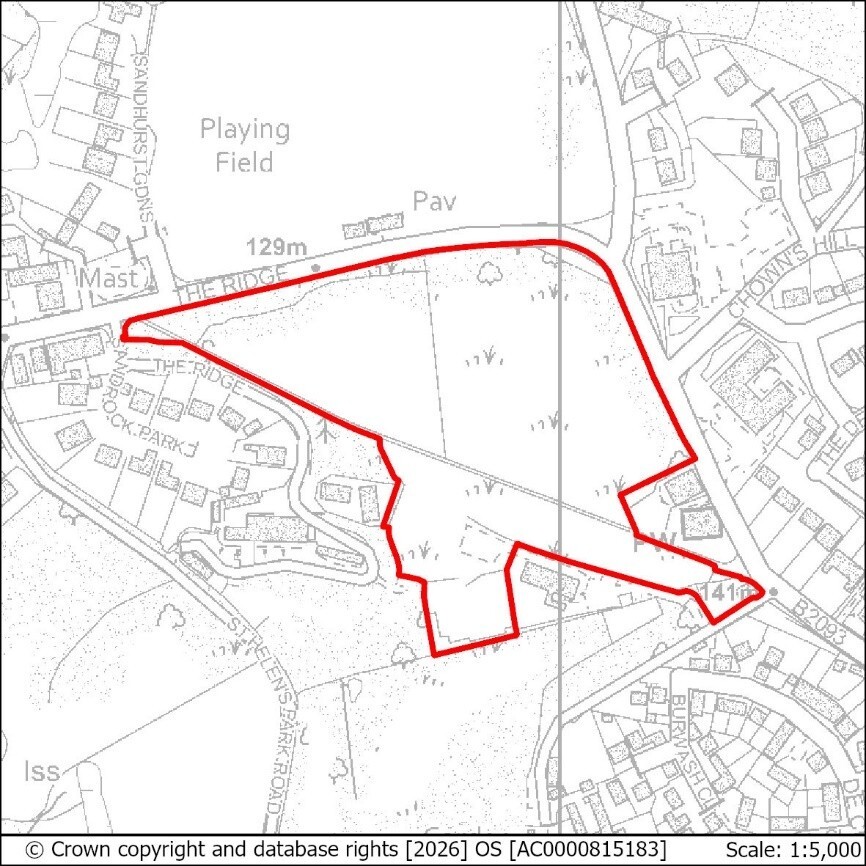
HS1: Land adjacent to Sandrock Park, The Ridge
Use: Residential
SHELAA Reference: HL140
Minimum Indicative Capacity (net additional dwellings): 95
Site Area (gross area): 3.9ha
Site Area (net developable area): 2.6ha
Proposals for Development on this site should:
- Be SuDS-led, and informed by an agreed programme of hydrological and groundwater monitoring;
- Provide affordable housing requirement in line with Policy SP2;
- Include a Flood Risk Assessment (FRA) and drainage strategy taking into account all sources of flooding and ground conditions. The drainage strategy should be informed by an agreed programme of monitoring as set out in (a) above. The FRA and its recommendations should fully take into account sensitive receptors downstream, the results of groundwater monitoring and ground condition surveys, the need to avoid creating new hydrological pathways to and from areas of contamination risk, and ensure that flood risk is not increased elsewhere;
- Incorporate measures that will protect sensitive receptors downstream from the introduction of new sources of pollution, including during the site preparation and construction phases of development;
- Take into account Southern Water’s infrastructure the crosses the site, and ensure easements are provided;
- Ensure that any necessary reinforcement of the sewerage system is in place to accommodate the quantum and type of proposed development prior to connection, and that such reinforcement is agreed with Southern Water. This will be secured by condition;
- The site's drainage strategy must be supported by a maintenance and management plan to ensure it will be managed for the lifetime of the development. This plan must be presented as a standalone document. Where any new, retained or improved flood mitigation or adaptation measures are included within the development an additional standalone maintenance and management plan must be produced;
- Include a Historic Environment Record (HER) informed desk-based assessment of potential interests within an Archaeological Notification Area and agree to an appropriate programme of archaeological investigation secured by condition/s prior to any development works (as advised by ESCC).
- Include a View Analysis to assist in demonstrating that the proposal would not cause unacceptable harm or loss of significance to the Ore Place Conservation Area, Manor House and remains of St Helen’s Church
- Be of a high quality with a strong visual architectural character and appearance and should retain and restore The Lodge (Lodge Cottage).
- Retain and enhance the Public Rights of Way within the site following the principles of crime prevention through environmental design and support connections to the wider walking and cycling network and improve provision of pedestrian facilities to key local services.
- Provide an area equivalent to at least 1/3 of the site for onsite open space, habitat creation, and delivery of green and blue infrastructure. Publicly accessible open space will be secured by legal agreement in perpetuity and must be of a size and quality that supports recreational use.
- Retain, enhance or provide boundary landscaping and noise screening, not all of which should be publicly accessible, to act as a buffer:
- From The Ridge and existing residential development, excluding the access point to the site, and;
- To the Local Nature Reserve and Local Wildlife Site
- Be supported by an Ecological Impact Assessment (EcIA) and include an Ecological Constraints and Opportunities Plan (ECOP) and incorporate appropriate conservation and mitigation measures as recommended by the EcIA. The ECOP must make specific reference to woodland within and adjacent to the site, the High Weald National Landscape, St. Helens Wood Local Wildlife Site and Local Nature Reserve, the results of hydrological and groundwater monitoring, and surveys of the site itself. The assessment must take into account any additional recreational impacts that may result from the proposal during all phases of development.
- Be supported by a Transport Report indicating how the conclusions and recommendations of the Report have been incorporated within the development and setting out a ‘monitor and manage’ regime.
- Ensure vehicular access to the site meets appropriate highways standards.
Policy HS2: Seaside Road, West St Leonards Comment
6.31Seaside Road, West St Leonards is a vacant brownfield site with potential to be used as a mixed-use development incorporating 120 residential dwellings alongside commercial, leisure or recreational uses. This site should deliver a high-quality destination leisure environment for both visitors and residents alike, and provide clear links to the existing walking, wheeling and cycling network to create a vibrant and active connection to the wider seafront including the beachside area of the Combe Valley Countryside Park.
6.32Seaside Road is one of the few remaining significant re-development sites within the seafront resort area. It presents an opportunity to create a high-quality development which, together with the adjacent Cinque Ports Way site, will both regenerate the area and act as a tourist attraction in its own right. The development should seek cohesion with the nearby Bexhill Road Local Centre by improving existing pedestrian and cycle access along Grosvenor Gardens and creating an attractive and safe route for residents and visitors that is well-integrated with the existing A259 crossing point that links the site to West St Leonards Station.
6.33Commercial, recreational and leisure uses should be sensitive to and compatible with the seafront location of the development and should take advantage of opportunities to create a broad promenade for pedestrians and cyclists behind the seawall running east to west across the site and improve access to the beach itself. This should also act as a way of protecting views along the seafront.
6.34As part of the recreation offer, public open space must be delivered in the northern part of the site opposite Seaside Way due to the presence of an underground water tank. There is an existing playground on the site that must be retained or sympathetically relocated to the same standard or better prior to the occupation of the development.
6.35The site is in close proximity to the APIB and within the ACIB of the East Sussex and Brighton and Hove Local Nature Recovery Strategy, with the Local Wildlife Site to the west and the Marine Conservation Zone (MCZ) and Special Protection Area (SPA) to the south. There are mapped measures for nature networks within and adjacent to the site. Existing areas of vegetative shingle habitat should be protected with opportunities explored for enhancement using appropriate native species of local provenance.
6.36There is tidal and fluvial flood risk (Zone 3) with a high groundwater table on the site and so a Flood Risk Assessment taking into account all potential sources of flooding will be required, and mitigation as advised by the report, should be incorporated into any potential scheme and maintained for its lifetime. Improvements to the seawall will be required. Safe access and exit for all residents must be provided.
6.37Sustainable Drainage Systems (SuDS) for the site may need to be highly bespoke and should ensure that any potential for contamination of sensitive receptors both within and surrounding the site arising from recreational, residential and highway use arising from development is mitigated appropriately.
6.38The eastern part of the site contains filled land and there have been previous commercial uses elsewhere on the site. Proposals will be expected to provide an assessment of ground conditions and potential contamination.
6.39Southern Water have a number of underground assets within the site, including tanks and pumping facilities. Easements to allow the maintenance of assets will need to be provided and maintained. Consultation with Southern Water is recommended at an early stage to inform any proposed scheme.
6.40Local sewerage infrastructure in closest proximity has limited capacity to accommodate the proposed development. Proposals for development at this location may therefore generate a need for reinforcement of the wastewater network should more detailed modelling show that additional capacity is needed. Proposals should demonstrate engagement with Southern Water at the earliest possible point to understand reinforcement needs, and any reinforcement must be completed prior to connection. This means that development cannot be occupied until it is demonstrated that reinforcement is fully completed.
6.41The site, given its size and location, will be expected to support a varied housing mix including affordable housing.
6.42The Council will expect to see a high-quality innovative design with particular regard to sustainability. The Grosvenor Gardens Conservation Area sits immediately to the east of this site. Any new development must sustain and enhance the setting of the conservation area.
6.43The location, scale and massing of housing units should have regard to the outlook of adjacent properties in Seaside Road and Grosvenor Gardens. Opportunities should be taken where possible to exploit the sea views that the site offers.
Figure 9: Seaside Road, West St Leonards
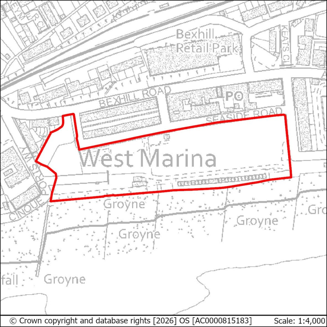
HS2: Seaside Road, West St Leonards
Use: Mixed Use: Residential, Commercial and Leisure.
SHELAA Reference: HL9
Minimum Indicative Capacity (net additional dwellings): 120
Site area (gross): 2.22ha
Proposals for development on this site should:
- Provide affordable housing requirement in line with Policy SP2.
- Include leisure, recreation and/or commercial uses that are sensitive to and compatible with the seafront location.
- Explore opportunities for co-ordinating development with the Cinque Ports Way site (HS11), or allowances made, including any road and junction improvements.
- Include walking and cycling links to ensure local connectivity, including to local community infrastructure, green spaces and public transport provision, taking into account site topography. This could include:
- Strengthening the link to West St Leonards Station and the cycle route and public right of way at the south of the site;
- Accessible pedestrian routes to the A259 bus corridor, incorporating high quality bus passenger waiting facilities;
- Ensuring vehicular assess to the site does not conflict with the cycleway/promenade to the south of the site;
- A transport assessment and a travel plan, with particular consideration of the potential impact on the A259 corridor.
- Ensure that the overall design responds to underground constraints, including Southern Water’s underground infrastructure in the design of the layout of the site. Easements would be required, which may affect the site layout or require diversion, and these should be clear of all proposed buildings and tree planting.
- Ensure that any necessary reinforcement of the sewerage system is in place to accommodate the quantum and type of proposed development prior to connection, and that such reinforcement is agreed with Southern Water. This will be secured by condition.
- Avoid unacceptable harm to the significance and setting of the Grosvenor Gardens Conservation Area.
- Be supported by an Ecological Impact Assessment (EcIA) and include an Ecological Constraints and Opportunities Plan (ECOP) and incorporate appropriate conservation and mitigation measures as recommended by the EcIA. The ECOP must make specific reference to the close proximity to the APIB, including the nearby Local Wildlife Site and Marine Conservation Zone/Special Protection Area to the south, and to other nearby areas of wildlife sensitivity.
- Minimise harm to vegetative shingle habitat and enhance where possible using appropriate native species.
- Provide a public realm and promenade that is attractive and inviting to residents and tourists that should also act as a way of protecting views along the seafront. Pedestrian access to the beach should be enhanced, particularly to the west of the site near the existing access at Cinque Ports Way.
- Provide new public open space land above the underground tank in the north of the site with informal opportunities for ‘play’ integrated into the design of the site and retaining or relocating the existing play space.
- Include a Flood Risk Assessment (FRA) and drainage strategy taking into account all sources of flooding, potential for contamination and ground conditions and be informed by appropriate hydrological monitoring. This should include improvements to the sea wall and contributions to ongoing maintenance in light of tidal and fluvial flood risk (Zone 3) which should be secured by legal agreement. Proposed improvements to sea defences should also take account of their impact upon Impact Risk Zones for Dungeness, Romney Marsh and Rye Bay SPA marine area and the Beachy Head East MCZ and mitigate any harms caused.
- The FRA must demonstrate that the proposal will be safe from flooding for its intended lifetime taking into account climate change and residual risk, taking into account sensitive receptors downstream and how the layout and mitigation measures will support this while also ensuring that flood risk is not increased elsewhere.The site's drainage strategy must be supported by a maintenance and management plan to ensure it will be managed for the lifetime of the development. This plan must be presented as a standalone document. Where any new, retained or improved flood mitigation or adaptation measures are included within the development an additional standalone maintenance and management plan must be produced.
- Incorporate a creative design response to integrating the electricity substation.
- Provide a connection to the sewerage system at the nearest point of adequate capacity, as advised by Southern Water and ensure future access to the existing sewerage and water supply infrastructure for maintenance and upsizing purposes.
Policy HS3: Former Westerleigh School Comment
6.44Former Westerleigh School provides an opportunity for redevelopment of the former school site.
6.45The topography of the land, the existing mature trees within the site and important nature conservation issues will need to be explored in any scheme that is put forward for this site.
6.46The site, given its size and location, will be expected to support a varied housing mix and affordable housing will also be required. Of particular importance for this site will be measures to reduce surface water flood risk, and Sustainable Drainage Systems are likely to be required. Connections between the green space protected on site and those existing green spaces off site will also need to be shown on any application to ensure the conservation and enhancement of the green infrastructure network.
6.47The site will require vehicular access to the site that is developed to an adoptable standard. The potential vehicular access does not need to follow the line of the existing road and can consider land to the south of the existing access.
Figure 10: Former Westerleigh School
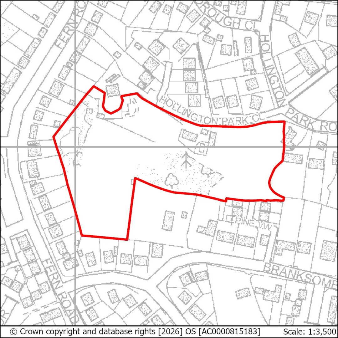
HS3: Former Westerleigh School
Use: Residential
SHELAA Reference: HL10
Minimum Density Range: 45-55 dwellings per hectare
Minimum Indicative Capacity (net additional dwellings): 100
Sites Area (gross): 2.15ha
Proposals for Development on this site should:
- Provide affordable housing requirement in line with Policy SP2;
- Be informed by slope stability reports and a geotechnical report due to the site topography;
- Maintain existing green corridors or replace them with comparative new green corridors;
- Be supported by an Ecological Impact Assessment (EcIA) and include an Ecological Constraints and Opportunities Plan (ECOP) and incorporate appropriate conservation and mitigation measures as recommended by the EcIA. The ECOP must make specific reference to surveys of the site itself and to other nearby areas of wildlife sensitivity.
- Construct vehicular access to the site to an adoptable standard;
- Include walking and cycling links to improve local connectivity, including to local community infrastructure, green spaces and public transport provision, taking into account site topography;
- Take account of Southern Water's underground infrastructure in the design of the layout of the site. Easements would be required, which may affect the site layout or require diversion, and these should be clear of all proposed buildings and tree planting;
- Provide an Arboriculture Plan that demonstrates how existing trees and proposed new trees on the site will be integrated into the development.
Policy HS5: Former West St Leonards Primary School, Bexhill Road Comment
6.48Former West St Leonards Primary School is a brownfield site in the west of the borough. The site slopes north to south and is vulnerable to flooding from surface water and river flooding. The site is part of the South Saxons Local Wildlife Site (LWS).In view of this ecological sensitivity, and the need to address flood risk sequentially within the site, the built portion of any development proposal should be confined to the north of the Public Right of Way (PROW) which crosses the site. This site is suited to a low-rise apartment style scheme.
6.49The Hollington Stream runs alongside the eastern boundary. Parts of the site to the south and west are in Flood Zone 3b, and a Flood Risk Assessment taking into account all potential sources of flooding will be required. Mitigation as advised by the report should be incorporated into any potential scheme and maintained for its lifetime. The Hollington Stream to the east and south of the site is an important ecological asset and is also engineered to avoid unacceptable flood risk so close working with the council and the Environment Agency is encouraged. Safe access and exit for all residents must be provided.
6.50Adequate buffer zones should be incorporated into any proposal that takes into account riparian zones, the impacts of climate change on flood risk, BAP Priority Habitat (deciduous woodland) to the west of the site and Southern Water’s infrastructure to the south-east. Natural Flood Management Measures, such as floodplain restoration, may be appropriate within this site.
6.51Sustainable Drainage Systems (SuDS) for the site may need to be highly bespoke and should ensure that any potential for contamination of sensitive receptors both within and surrounding the site arising from recreational, residential and highway use arising from development is mitigated appropriately. Easements should be provided to allow the monitoring of water quality.
6.52Mitigations should not interfere with the existing hydrological regime of the site due to the potential for impact on wetland habitats. The site will require hydrological monitoring to determine the potential for impact, and this should in turn inform ecological assessment of the site. Any discharge rates must be agreed with the Pevensey and Cuckmere Water Level Management Board before any planning permission is granted.
6.53The site sits within the South Saxons Local Wildlife Site (LWS) and is in the main neutral grassland with a small reedbed in the south-west corner. The LWS and the Hollington Stream must be specifically referenced in any Ecological Constraints and Opportunities Plan (ECOP), and the site itself should be thoroughly surveyed to identify constraints, taking into account the ecological and recreational impact of development. The BNG assessment must include a River Condition Assessment. Any development proposal must seek to avoid or minimise impact on these areas during both the construction and occupation phases of the development
6.54Proposals for the development of the site should seek to retain and enhance the Public Right of Way (PROW) within the site that connects Edinburgh Road to Filsham Road.
6.55The site was formerly landfill and may still produce landfill gas. There is also a small area of contaminated land in the north-western corner of the site. An assessment of potential contamination will therefore be required.
6.56Vehicle access must meet acceptable highways standards, and a transport report will be required for the site.
Figure 11: Former West St Leonards Primary School.
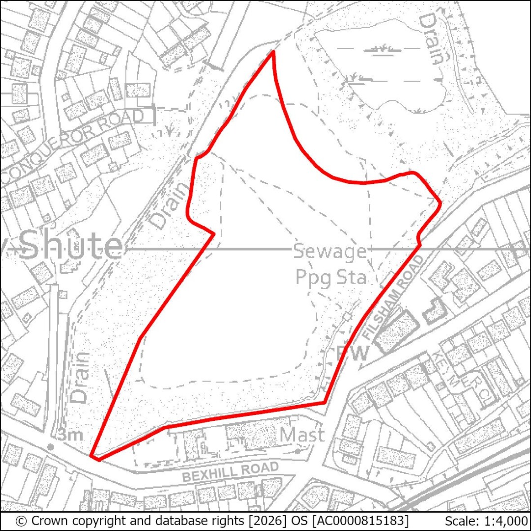
HS5: Former West St Leonards Primary School, Bexhill Road
Use: Residential
SHELAA Reference: HL115
Minimum Indicative Capacity (net additional dwellings): 50
Site Area (gross area): 3.5ha
Sites Area (net developable area): 0.8ha
Proposals for Development on this site should:
- Provide affordable housing requirement in line with Policy SP2;
- Locate and confine the built portion of the proposal to the north of the PROW within the site;
- Include a Flood Risk Assessment (FRA) and drainage strategy that informs scheme design and layout, taking into account all sources of flooding, potential for contamination and ground conditions and be informed by appropriate hydrological monitoring. The FRA and its recommendations should fully take into account the engineering of the Hollington Stream;
- Proposals must ensure that a sequential approach informed by the FRA is taken within the site to direct more vulnerable uses to the lowest areas of flood risk taking into account (b) above;
- The site's drainage strategy must be supported by a maintenance and management plan to ensure it will be managed for the lifetime of the development. This plan must be presented as a standalone document. Where any new, retained or improved flood mitigation or adaptation measures are included within the development an additional standalone maintenance and management plan must be produced.
- Consider the use of Natural Flood Management Measures to help manage flood risk within the site and provide easements to allow continued monitoring of the Hollington Stream;
- Have discharge rates agreed with the Pevensey and Cuckmere Water Level Management Board (PCWLMB) prior to granting of permission;
- Incorporate buffer zones around watercourses (10m), BAP Priority Habitat to the west (15m) and any necessary allowances for climate change;
- Be supported by an Ecological Impact Assessment (EcIA), a River Condition Assessment and include an Ecological Constraints and Opportunities Plan (ECOP) and incorporate appropriate conservation and mitigation measures as recommended by the EcIA. The ECOP must make specific reference to the Hollington Stream, South Saxons Local Wildlife Site and multiple priority habitats present within the site. The assessment must take into account any additional recreational impacts that may result from the proposal during all phases of development;
- Biodiversity Net Gain assessments (BNG) will require a River Condition Assessment (RCA) and buffers in excess of those required for flood risk management;
- Retain and enhance the PROW within the site, and support connections to the wider walking and cycling network and key transport hubs including the station at West St Leonards;
- Be supported by a Transport Assessment, following a vision-led and validate approach and including a provision for monitor and manage transport interventions. Proposals must also indicate how the conclusions and recommendations of the Report have been incorporated within the development;
- Take account of Southern Water's underground infrastructure in the design of the layout of the site. Easements would be required, which may affect the site layout or require diversion, and these should be clear of all proposed buildings and tree planting;
- Ensure vehicular access to the site meets appropriate highways standards, and be capable of providing safe access and exit from the site during flood events.
Policy HS6: Ore Valley (Former Power Station) Comment
6.57The Ore Valley (Former Power Station) is a brownfield former industrial site with potential for residential redevelopment.
6.58The developable parts of this site are confined to the southern half and a smaller area to the north. The remainder of the site is woodland, which should be retained and arrangements made for its management. Access is available from an existing access point to Fellows Road at the eastern end of the site.
6.59The site is located in an area of deep surface water flood risk, and Southern Water has indicated that there is currently insufficient sewerage capacity to serve the site. It is also located adjacent to a designated Local Wildlife Site and will require its own ecological assessment in terms of future development.
6.60Local sewerage infrastructure in closest proximity has limited capacity to accommodate the proposed development. Proposals for development at this location may therefore generate a need for reinforcement of the wastewater network should more detailed modelling show that additional capacity is needed. Proposals should demonstrate engagement with Southern Water at the earliest possible point to understand reinforcement needs, and any reinforcement must be completed prior to connection. This means that development cannot be occupied until it is demonstrated that reinforcement is fully completed.
6.61The site will be expected to support a varied housing mix, including affordable housing. Given the previous uses of this site there is potential for contamination, which would need to be investigated.
Figure 12: Ore Valley (Former Power Station).
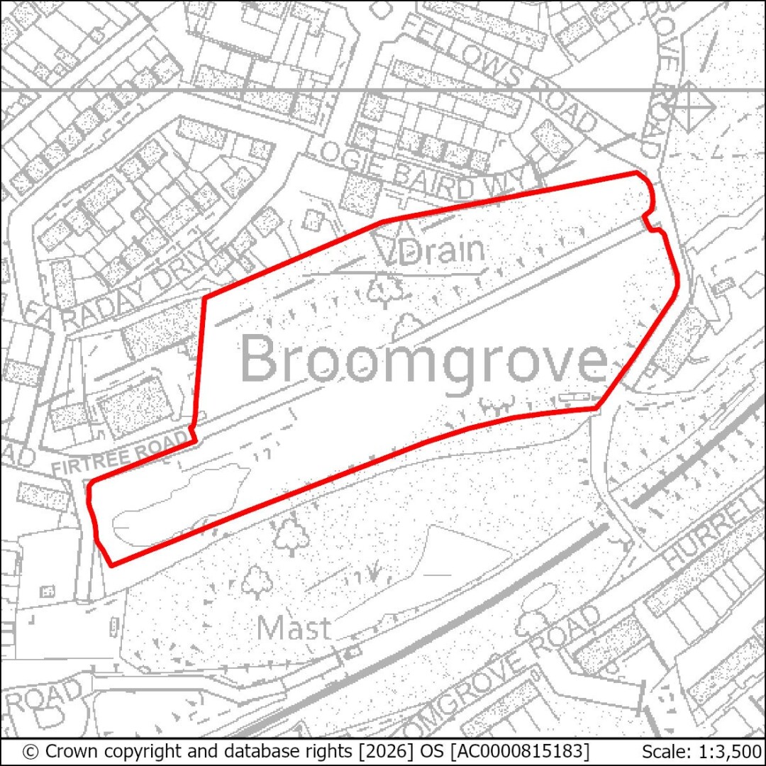
HS6: Ore Valley (Former Power Station)
Use: Residential
SHELAA Reference: HL39
Minimum Indicative Capacity (net additional dwellings): 78
Site Area (gross): 2.36ha
Proposals for Development on this site should:
- Provide affordable housing requirement in line with Policy SP2;
- In all cases retain the woodland area to the north of the site corresponding to approximately 0.85 ha (capacity has been calculated net of this site area);
- Be informed by a Transport Assessment and Travel Plan, following a vision-led approach, and including a provision for ‘monitor and manage’ for transport interventions. The active travel element should include walking and cycling links to ensure local connectivity to Ore Station, including to local community infrastructure, green spaces and public transport provision, taking into account site topography;
- Ensure vehicular access to the site meets appropriate highways standards;
- Be supported by a Flood Risk Assessment and detailed Drainage Strategy which considers the following:
- The high groundwater table and implementation of a suitable drainage strategy informed by onsite monitoring and soil percolation testing;
- The provision of a storage pond in the western part of the site. The drainage strategy should seek to attenuate surface water within the pond before discharging into the culverted Ordinary Watercourse in the southern part of the site.
- Take account of Southern Water's underground infrastructure in the design of the layout of the site. Easements would be required, which may affect the site layout or require diversion, and these should be clear of all proposed buildings and tree planting;
- Ensure that any necessary reinforcement of the sewerage system is in place to accommodate the quantum and type of proposed development prior to connection, and that such reinforcement is agreed with Southern Water. This will be secured by condition;
- Assess the ecological and recreational impact of the proposed development on the adjacent Broomgrove Local Wildlife Site. Proposals should seek to avoid or mitigate any identified impact.
Policy HS7: Former Post Office and University of Brighton building Comment
6.62The Former Post Office and University of Brighton building is a town centre brownfield site. The site is suitable for mixed use development, with retail uses at the ground floor to provide an active frontage to the development. The site will be expected to support a varied housing mix and to include affordable housing.
6.63New development will have to take account of the amenity of adjoining residents and businesses due to the town centre location. The development should preserve and enhance the Hastings Town Centre conservation area and take consideration of views to and from Hastings Castle.
6.64Proposals should support ensuring that the public realm in Priory Square is enhanced and provide appropriate improvements to open space and street furniture.
Figure 13: Former Post Office and University of Brighton building
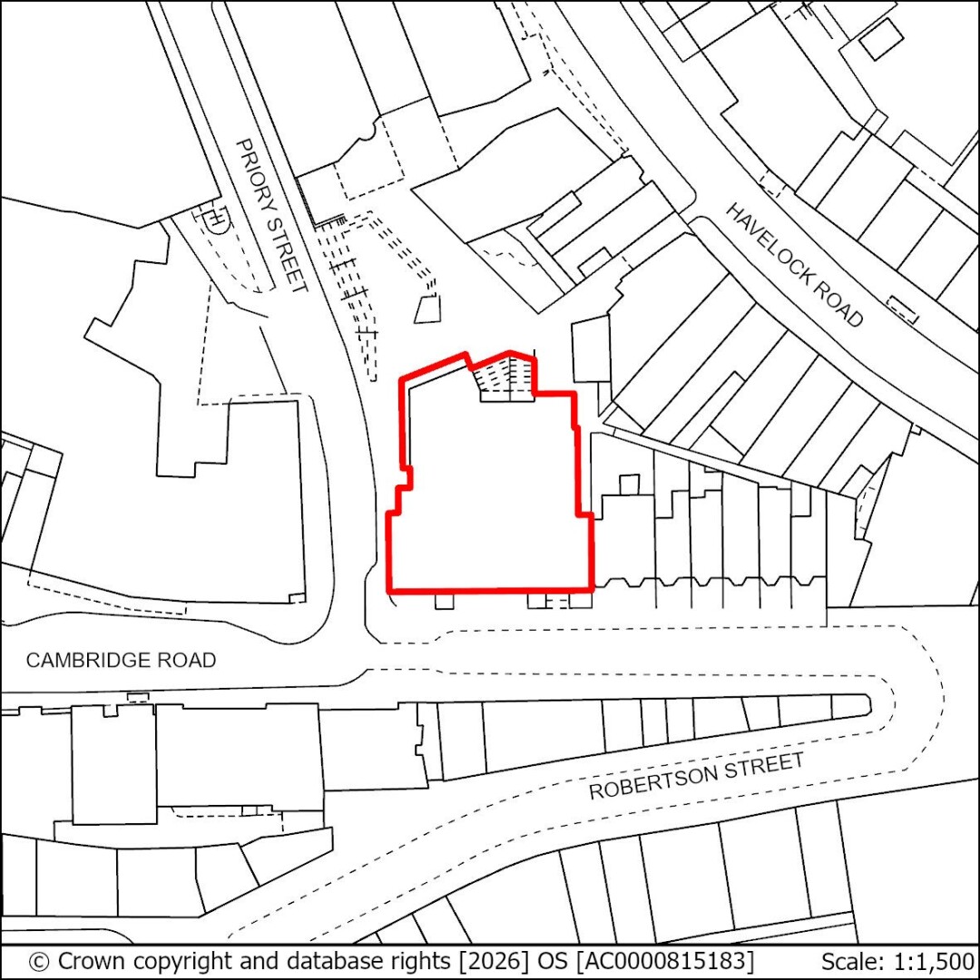
HS7: Former Post Office and University of Brighton building
Use: Mixed Use
SHELAA Reference: HL138
Minimum Indicative Capacity (net additional dwellings): 41
Site Area (gross): 0.1ha
Proposals for Development on this site should:
- Provide affordable housing in line with Policy SP2.
- Enhance public realm within Priory Square, including policy compliant ‘greening’ to the site in a form appropriate to the urban setting, seating and improvements to open space to encourage active and positive daytime use and support the promotion of Priory Street as a secondary route to the Town Centre and Bohemia.
- Provide for active uses at ground floor level which should include retail, leisure or other town centre complementary uses which also preserve the frontage of the former post office building.
- Avoid unacceptable harm to the significance of the Hastings Town Centre conservation area and long-range views of and from Hastings Castle.
- Take appropriate measures to mitigate the impact of noise on residential dwellings due to location within the active nighttime economy setting.
- Enhance Priory Square itself following the principles of Secured by Design to create a safe and welcoming space for all users.
- Include easements for works and infrastructure access to surrounding premises.
- Provide a connection to the sewerage system at the nearest point of adequate capacity, as advised by Southern Water and ensure future access to the existing sewerage and water supply infrastructure for maintenance and upsizing purposes.
Policy HS8: Mayfield E, Bodiam Drive Comment
6.65Mayfield E, Bodiam Drive is a gently sloping site at the edge of an existing residential area, and there is the potential for this site to accommodate at least 38 dwellings. This site is in council ownership, and consideration has been given to the sale value of the land which the Council hopes to achieve and the potential for the site to provide affordable housing. The council is working to ensure that the site delivers 100% affordable housing.
6.66There are opportunities to connect this site to the Mayfield Farm development by road or footpath which would aid permeability, making it easier for people to travel to and from their homes. There is also a good opportunity to include an access footpath to the existing bus stop on Bodiam Drive at the north-east corner of the site.
6.67Landscaping and potentially noise screening (hedging for example), is likely to be required along the western border of the site to shield the development from the Queensway Road. Any development on this site could potentially affect the setting of Mayfield Farmhouse; a Grade II listed building that is sited immediately to the south-west. Due to the size of the site, a Flood Risk Assessment is required.
Figure 14: Mayfield E, Bodiam Drive
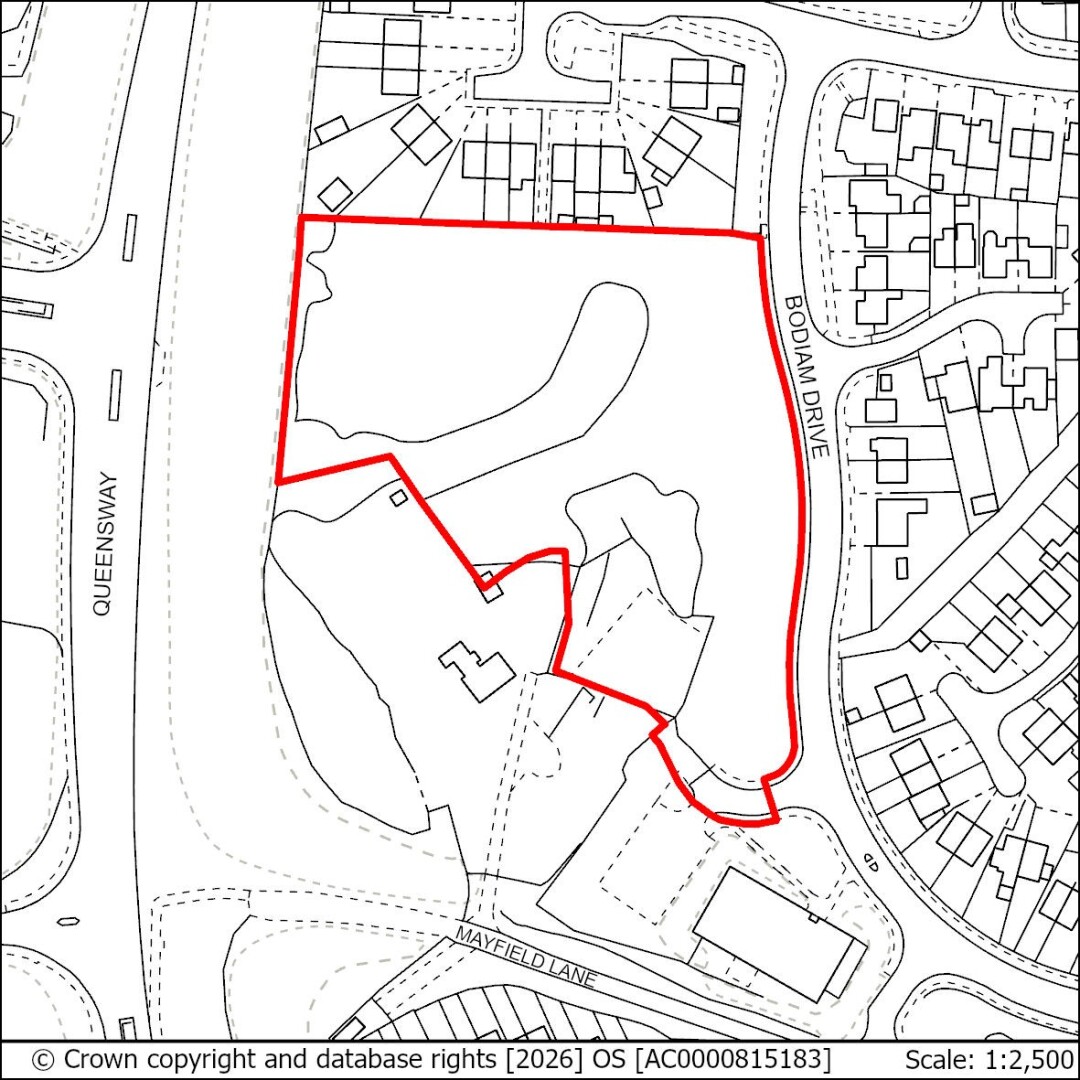
HS8: Mayfield E, Bodiam Drive
Use: Residential
SHELAA Reference: HL4
Minimum Indicative Capacity (net additional dwellings): 38
Site Area (gross): 1.06ha
Proposals for Development on this site should:
- Provide affordable housing.
- Be informed by a Transport Assessment and Travel Plan, following a vision-led approach, and including a provision for ‘monitor and manage’ for transport interventions including consideration of connections to and through Mayfield Farm (HSS16). Active travel should be prioritised and include walking and cycling links to improve local connectivity, including to local community infrastructure, green spaces and public transport provision taking into account site topography.
- Avoid unacceptable harm to the significance and setting of the Grade II listed Mayfield Farmhouse that is sited immediately to the south-west of the site.
- Provide boundary landscaping and noise screening along the western border of the site to act as a buffer to Queensway to the west.
- Ensure the existing depression to the south of the site is retained and incorporated into the surface water drainage system as part of the proposed development.
- Take account of Southern Water's underground infrastructure in the design of the layout of the site. Easements would be required, which may affect the site layout or require diversion, and these should be clear of all proposed buildings and tree planting.
- Provide an Arboriculture Plan that demonstrates how existing trees on the site will be integrated into the development particularly those contained within the south-eastern corner of the plot and those that border the curtilage of the listed building.
- Ensure the existing green corridor is maintained or replaced by comparative new green corridors.
- Ensure the layout of the site is arranged so that the rear private gardens of the residential units are positioned immediately adjacent to the boundary of the farmhouse to protect the setting of the listed building. Hedging should be considered to reinforce the natural screening rather than walls or fences.
Policy HS10: Land at Rock Lane Comment
6.68Land at Rock Lane is a greenfield site located at the boundary with Rother District Council. The site adjoins a development to the northern boundary in Rother. The site is located in the High Weald National Landscape Area of Outstanding Natural Beauty (AONB). The site is suitable for residential development and would be expected to achieve 40% affordable housing and provide a variety of types and tenures of housing.
6.69Design proposals would need to be sensitive to the location of the site within the National Landscape and have consideration to providing an active frontage to Rock Lane. The development would need to ensure that easements and buffers are secured to infrastructure on site including drains and overhead power lines.
6.70The site will require an Ecological Constraints and Opportunities Plan (ECOP) and any proposal must also be informed by an Ecological Impact Assessment (EcIA). Assessments must take into account any nearby areas of wildlife sensitivity and the site itself should be thoroughly surveyed to identify constraints, taking into account the ecological and recreational impact of development. Any development proposal must seek to avoid or minimise impact on ecologically sensitive areas during both the construction and occupation phases of the development. The site is within an ACIB with mapped measures for nature networks. The development would need to ensure that an ecological management plan is developed for the site.
Figure 15: Land at Rock Lane
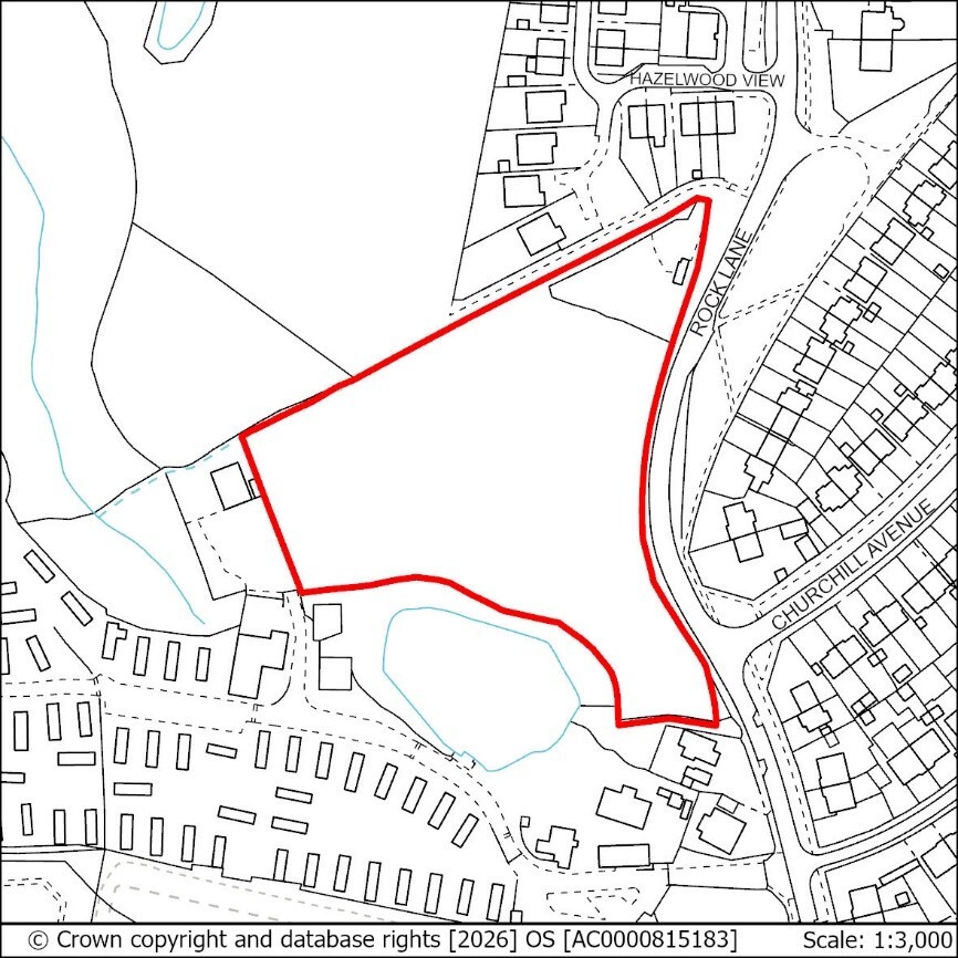
HS10: Land at Rock Lane
Use: Residential
SHELAA Reference: HL63
Minimum Indicative Capacity (net additional dwellings): 26
Site Area (gross): 1.2ha
Proposals for Development on this site should:
- Provide affordable housing requirement in line with Policy SP2.
- Include an appropriate and safe buffer at the eastern boundary of the site (adjacent Rock Lane) due to presence of overhead power lines.
- Create a frontage along Rock Lane and demonstrate the conservation and enhancement of the National Landscape (AONB) showing how adverse impacts will be avoided. Proposals must demonstrate a landscape-led approach to design and layout, which should follow the advice in the High Weald AONB Housing Design Guide.
- Safeguard the Dark Skies of the High Weald National Landscape in line with the Dark Skies Technical Advice Note.
- Maintain a 5m buffer to the existing drain along the northern boundary of the site.
- Provide multi-functional open and play space, including a maintenance and management plan for their lifetime.
- Be supported by an Ecological Impact Assessment (EcIA) and Ecological Constraints and Opportunities Plan (ECOP), and incorporate appropriate conservation and mitigation measures as recommended by the EcIA. The ECOP must make specific reference to the High Weald National Landscape, site surveys, and to other nearby areas of wildlife sensitivity. Opportunities for enhancement should have regard to the LNRS;
- Include a Management Plan for the identified Ecology Zone, including measures for the management and ongoing maintenance of that area.
- Be informed by a Transport Assessment and Travel Plan, following a vision-led approach, and including a provision for ‘monitor and manage’ for transport interventions. Active travel should be prioritised and the proposals should include and enhance walking and cycling links to ensure local connectivity, access to the wider National Landscape (AONB) and Ivyhouse Lane Employment Area, including to local community infrastructure, green spaces and public transport provision, taking into account site topography.
- Provide vehicular access from Rock Lane to be provided in accordance with highway standards, footway provision along the frontage and suitable ccrossing facilities to access bus stops on Churchill Avenue.
- Have regard to any relevant policies from Rother District Council development plan documents.
Policy HS11: Cinque Ports Way Comment
6.71Cinque Ports Way has redevelopment potential for a low-rise apartment-led scheme. Any proposals are encouraged to explore opportunities for co-ordinating development with the Seaside Road site (HS2), or allowances made to better enable this, including road and junction improvements
6.72In relation to archaeological potential, the site lies at least partially over Quaternary deposits which hold potential to preserve significant archaeological and/or paleoenvironmental evidence, including waterlogged organic remains. This below ground historic environment potential should be assessed and recorded.
6.73The site will require an Ecological Constraints and Opportunities Plan (ECOP) and any proposal must also be informed by an Ecological Impact Assessment (EcIA). Assessments must take into account the adjacent Local Wildlife Site and any nearby areas of wildlife sensitivity and the site itself should be thoroughly surveyed to identify constraints, taking into account the ecological and recreational impact of development. Any development proposal must seek to avoid or minimise impact on ecologically sensitive areas during both the construction and occupation phases of the development. The site is within an ACIB with mapped measures for nature networks. The development would need to ensure that an ecological management plan is developed for the site.
6.74There is a Public Right of Way (and a National Cycle Route) running along the southern boundary, which it will be important to link to. There is a Local Wildlife Site adjacent to the west; and avoidance of harm to it is of high importance and as such an impact assessment will be required.
6.75This is a site that is in a flood risk area (from all types of flooding), protection and mitigation measures must be included in any scheme. Sustainable Drainage Systems (SuDS) are likely to be required along with potential contributions to the maintenance of the existing sea defences.
Figure 16: Cinque Ports Way
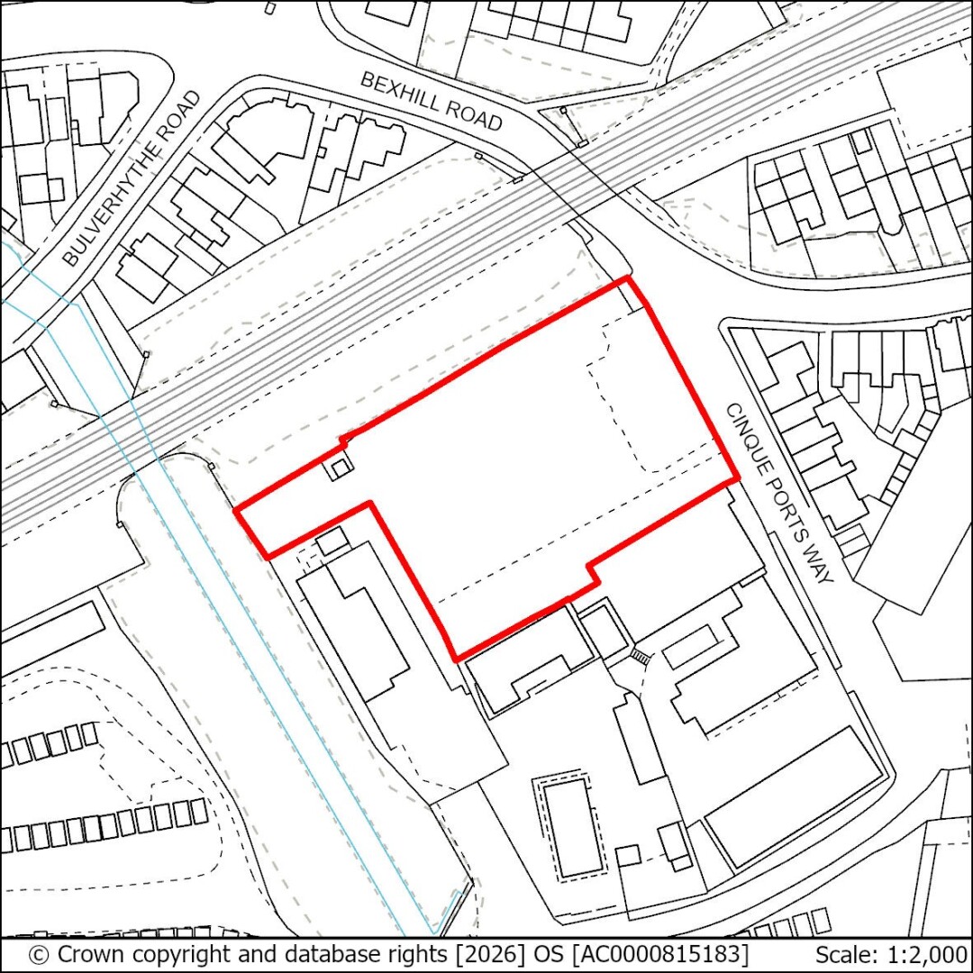
HS11: Cinque Ports Way
Use: Residential
Minimum Density Range: 90 - 150 dwellings per hectare
Minimum Indicative Capacity (net additional dwellings): 58
Site Area (gross): 0.37ha
Proposals for Development on this site should:
- Provide affordable housing in line with Policy SP2
- Include walking and cycling links to the A259 bus corridor, improve local connectivity, including to local community infrastructure, green spaces and public transport provision, including high-quality bus passenger waiting facilities.
- Be informed by a Transport Assessment and Travel Plan, following a vision led approach, and including provision for ‘monitor and manage’ for transport interventions. The proposals should enhance access to the public right of way and national cycle route that runs along the southern boundary and to the pedestrian walking and cycling routes to West St Leonards Station to improve connectivity.
- Avoid unacceptable harm to the setting of the Grosvenor Gardens Conservation Area, including opportunities for innovative design that responds well to the scale and character of the area.
- Consult relevant historic environment records and assess heritage assets using appropriate expertise including, where necessary, a field evaluation.
- Be supported by an Ecological Impact Assessment (EcIA) and Ecological Constraints and Opportunities Plan (ECOP), and incorporate appropriate conservation and mitigation measures as recommended by the EcIA. The ECOP must make specific reference to the adjacent Bulverhythe Shingle Beach and Cliffs Local Wildlife Site, the results of site surveys, and to other nearby areas of wildlife sensitivity. Opportunities for enhancement should have regard to the LNRS and should include an ecological management plan;
- Provide a public realm and promenade that is attractive and inviting to residents and tourists and encourages foot or cycle journeys to the Bexhill Road Local Centre and St Leonards District Centre to the east.
- Assess the ecological and recreational impact of the proposed development on the Bulverhythe Shingle Beach and Cliffs Local Wildlife Site. Proposals should seek to avoid or mitigate any identified impact.
- Be supported by a Flood Risk Assessment and detailed drainage strategy that incorporates measures to address flood risk. This should include improvements to the sea wall and contributions to ongoing maintenance in light of tidal and fluvial flood risk which should be secured by legal agreement. This site has a high groundwater table and drainage design should be informed by onsite monitoring. Any improvements to sea defences should also take account of their impact upon Impact Risk Zones for Dungeness, Romney Marsh and Rye Bay SPA marine area and the Beachy Head East MCZ and mitigate any harms caused.
- Demonstrate that the proposal will be safe from flooding for its intended lifetime taking into account climate change and residual riskand sensitive receptors downstream and show how the layout and mitigation measures will support this while also ensuring that flood risk is not increased elsewhere.
- Have discharge rates agreed with the Pevensey & Cuckmere Water Level Management Board (PCWLMB) prior to granting of permission.
- Ensure future access to the existing sewerage infrastructure for maintenance and upsizing purposes is maintained. It should also take account of Southern Water's underground infrastructure in the design of the layout of the site. Easements would be required, which may affect the site layout or require diversion, and these should be clear of all proposed buildings and tree planting.
Policy HS12: Gambier House, 111 West Hill Road and West House, 115 West Hill Road Comment
6.76The site is a brownfield site, and the existing buildings were vacated by the NHS in July 2011. The site is in a prominent cliff top location that offers a good residential development opportunity.
6.77The site is located within the Grosvenor Gardens Conservation Area and the retention of the Gambier House building is preferred. Any scheme involving its demolition will need clear and convincing justification to demonstrate the reasoning behind such a proposal. The site has an existing access point that should be taken advantage of.
6.78The site will require an Ecological Constraints and Opportunities Plan (ECOP) and any proposal must also be informed by an Ecological Impact Assessment (EcIA). Assessments must take into account any nearby areas of wildlife sensitivity and the site itself should be thoroughly surveyed to identify constraints, taking into account the ecological and recreational impact of development. Any development proposal must seek to avoid or minimise impact on ecologically sensitive areas during both the construction and occupation phases of the development. The site is within an ACIB with mapped measures for nature networks. The development would need to ensure that an ecological management plan is developed for the site. It is also important that any adverse impacts on the adjacent Local Wildlife Site are avoided.
6.79The site is within the Western Landslide Activity Risk Area (LARA) as shown on the Policies Map, and has potential for land instability. Development should provide an enhanced land stability report and provide an appropriate buffer zone to the south, the extent of which should be determined by site specific land stability assessments and engineer reports. This buffer zone should include safe and accessible easements for the monitoring and management of any existing or planned cliff stabilisation measures, and the condition of the cliff in general. It is recommended that land stability assessments for this site take into account data derived from any ongoing land stability monitoring and modelling within this area. The primary interest of the adjacent LWS is the soft cliffs and the inverts that are dependent on them. Any stabilisation works will need to take this into account and either allow continued slippage or provide a suitable alternative.
6.80SuDS must be informed by both detailed drainage strategies and land stability assessments. SuDS must demonstrably be appropriate for the complex geotechnical character of the area.
Figure 17: Gambier House, 111 West Hill Road and West House, 115 West Hill Road
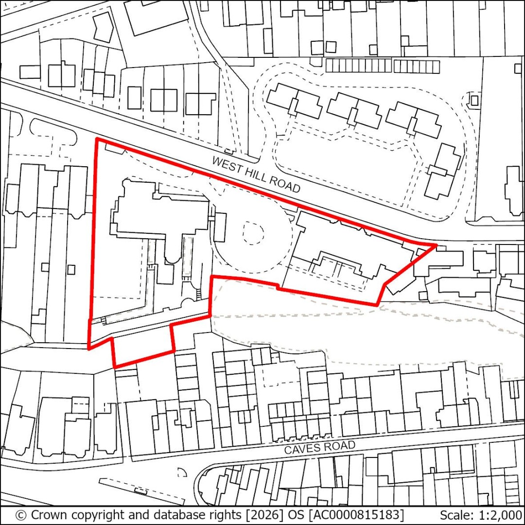
HS12: Gambier House, 111 West Hill Road and West House, 115 West Hill Road
Use: Residential
SHELAA Reference: HL111
Minimum Indicative Capacity (net additional dwellings): 20
Site Area (gross): 0.55ha
Proposals for Development on this site should:
- Provide affordable housing in line with Policy SP2.
- Retain and restore Gambier House and incorporate infill development that should be designed to reflect the scale and strong visual architectural character and appearance of retained significant buildings within the site and the wider Conservation Area; Consider the removal of 20th century extensions, particularly the extension to the east of the historic core of West House and the 1½ storey roof extension capped with pyramidal roof.
- Ensure strategic spatial gaps between the built form that are characteristic of the conservation area to ensure a sense of openness.
- Ensure the existing access point is utilised.
- Be informed by land stability reports and a geotechnical report due to the proximity to cliff edge and possible presence of caves or voids within the cliff itself. Reports should take into account both the temporary (construction phase) and operational (occupation phase) condition of the site, proposing mitigations for each state.
- Ensure the layout of the site is arranged so that an undeveloped buffer zone informed by assessments of land stability is created at the southern extents of the site which shall be landscaped with appropriate planting to protect the cliff faces. Easements to safeguard access to maintain any existing or future land stability measures must be provided.
- Ensure SuDS designs are informed by the findings of land stability and detailed drainage reports, and that any new dead or imposed loads to be created by SuDS schemes are incorporated within the land stability and geotechnical assessments. This site also has a high groundwater table and drainage design should be informed by onsite monitoring and not use infiltration SuDS systems and include a new sewer connection for the site.
- Be supported by an Ecological Impact Assessment (EcIA) and Ecological Constraints and Opportunities Plan (ECOP) and incorporate appropriate conservation and mitigation measures as recommended by the EcIA. The ECOP must make specific reference to the adjacent Caves Road Cliffs Local Wildlife Site, the results of site surveys, and to other nearby areas of wildlife sensitivity. Opportunities for enhancement should have regard to the LNRS and should include an ecological management plan;
- Provide innovative solutions for any necessary on-site parking that do not dominate the site.
- Have discharge rates agreed with the Pevensey & Cuckmere Water Level Management Board (PCWLMB) prior to granting of permission.
- Include walking and cycling links to ensure local connectivity, including to local community infrastructure, green spaces and public transport provision, taking into account site topography.
Policy HS13: Land North-West of Winchelsea Lane Comment
6.81Land North-West of Winchelsea Lane is a greenfield site located in the High Weald National Landscape (AONB) adjacent to residential development in Rother District. The site is steeply sloping and will require a land stability assessment and a sensitive design response to the topography. The site has potential drainage issues and will need to incorporate Sustainable Drainage Systems (SuDS). The site is within the High Weald National Landscape and therefore a sensitive form of development is required in line with Local Plan policies.
6.82The site will require an Ecological Constraints and Opportunities Plan (ECOP) and any proposal must also be informed by an Ecological Impact Assessment (EcIA). Assessments must take into account any nearby areas of wildlife sensitivity and the site itself should be thoroughly surveyed to identify constraints, taking into account the ecological and recreational impact of development. Any development proposal must seek to avoid or minimise impact on ecologically sensitive areas during both the construction and occupation phases of the development.
6.83The council will expect any scheme to support a varied housing mix and affordable housing will also be required.
Figure 18: Land North-West of Winchelsea Lane
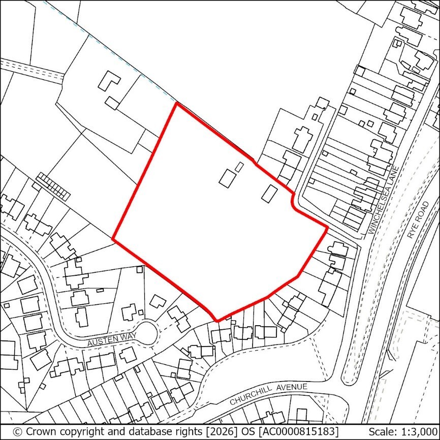
HS13: Land North-West of Winchelsea Lane
Use: Residential
SHELAA Reference: HL87
Minimum Indicative Capacity (net additional dwellings): 20
Site Area (gross): 1.17ha
Proposals for Development on this site should:
- Provide affordable housing in line with Policy SP2.
- Demonstrate the conservation and enhancement of the National Landscape showing how adverse impacts will be avoided, mitigated or compensated for. Proposals must demonstrate a landscape-led approach to design and layout, which should follow the advice in the High Weald AONB Housing Design Guide.
- Safeguard the Dark Skies of the High Weald National Landscape in line with the Dark Skies Technical Advice Note.
- Provide multi-functional open and play space in accordance with policy.
- Be supported by an Ecological Impact Assessment (EcIA) and Ecological Constraints and Opportunities Plan (ECOP), and incorporate appropriate conservation and mitigation measures as recommended by the EcIA. The ECOP must make specific reference to the High Weald National Landscape, the results of site surveys, and to other nearby areas of wildlife sensitivity;
- Include and enhance walking and cycling links to ensure local connectivity.
- Be supported by a Flood Risk Assessment and detailed Drainage Strategy.
- Retain and enhance any existing green infrastructure.
- Be informed by slope stability reports and a geotechnical report.
Policy HS18: Land at Tilekiln Farm Comment
6.84Land at Tilekiln Farm is a site in the east of the Borough close to Ore Village Local Centre. The site slopes steeply to the south-east towards the Bourne Stream which runs along the south-east boundary.
6.85The site is currently occupied in part by a former agricultural building towards the north-eastern corner with the remainder being open grassland which has previously been farmed but now lies fallow. The site is enclosed on three sides by residences which front onto Fairlight Road, Fairlight Avenue, Tilekiln Lane, Edith Road and Harold Road and the Bourne Stream itself. The site is currently accessed from Fairlight Avenue.
6.86The site is the northern valley slope within a larger landform and sits within the High Weald National Landscape. Therefore, the design of any scheme must be landscape-led to fit sensitively into the High Weald National Landscape taking into account any recommendations arising from site specific Landscape Studies and take into account the High Weald AONB Housing Design Guide. It is recommended that due to the scale of development proposed within this landscape sensitivity context, a period of public consultation takes place prior to the submission of a detailed planning application.
6.87Landscape Studies should show how natural boundary screening will be incorporated in a manner that is sensitive to its setting within the High Weald National Landscape, including retained trees and hedgerow and new strong buffers to define boundaries and soften visibility of existing rooflines.
6.88A lighting plan must be provided, and lighting schemes should be designed with regard to the High Weald National Landscape Dark Skies Technical Advice Note (TAN). Proposals also should seek to minimise light spill from internal sources in line with the Dark Skies TAN through design mitigations.
6.89To address localised deficiencies in access to open space and play within the Ore area and eastern Borough fringes, residential development and essential site infrastructure should cover no more than 2/3 of the site. The remainder of the site should be secured as public open space by legal agreement and include natural, unfenced and multifunctional play space that takes into account the recommendations of the High Weald AONB Housing Design Guide. A maintenance and management plan will be required for open space and play facilities provided onsite.
6.90The site experiences localised flooding along the course of the Bourne Stream and has a small area of Flood Zone 3b directly adjacent to the stream and an area of ponding in the centre of the site. There is also the potential for groundwater flooding or drainage constraints due to an elevated groundwater table and an agreed programme of hydrological and hydrogeological monitoring should be undertaken to inform relevant assessments and the site drainage strategy.
6.91A Flood Risk Assessment taking into account all potential sources of flooding will be required and mitigation as advised by the report should be incorporated into any potential scheme and maintained for its lifetime. The measures recommended by the report should ensure that a sequential approach to the location of development is taken in line with its level of vulnerability and that development will not contribute further to flooding associated with the Bourne Stream at lower elevations, and should include recommendations that have the potential to reduce flood risk to residential properties in nearby Clive Vale by reducing the flow rate of water entering the watercourse during heavy rainfall events.
6.92Adequate riparian buffer zones should be incorporated into any proposal that takes into account riparian zones and the impacts of climate change on flood risk. The Bourne Stream is a sensitive receptor and Sustainable Drainage Systems (SuDS) for the site should ensure that any potential for contamination of sensitive receptors both within and surrounding the site arising from recreational, residential and highway use arising from development is mitigated appropriately and existing surface water drains that discharge into the stream within the site are incorporated within any scheme, or an alternative solution is sought where this will reduce flow rates and reduce the introduction of potential pollutants to the stream. Easements should be provided to allow the monitoring of water quality.
6.93The site is within the ACIB with mapped measures for rivers and nature networks and this, the National Landscape and the Bourne Stream and the SSSI impact risk zone must be specifically referenced in any Ecological Constraints and Opportunities Plan (ECOP). The site itself should be thoroughly surveyed to identify constraints, taking into account the ecological and recreational impact of all stages of development. Assessments of BNG will require a River Condition Assessment. Any development proposal must seek to avoid, minimise or where this is not possible, mitigate impact on these areas during both the construction and occupation phases of the development.
6.94The site is also within an Archaeological Notification Area and will require both an assessment of potential interests and agreement of an appropriate programme of archaeological investigation.
6.95A transport study or assessment will be required to identify and ensure suitable access can be gained to the site. Opportunities to promote active travel should be included.
6.96Proposals for the development of the site should seek to retain and enhance the Public Right of Way (PROW) within the site that connects Fairlight Avenue to Barley Lane, identifying opportunities to connect the footpath to any new areas of public open space delivered through the scheme. Boundary screening around the footpath should be retained and enhanced where no new connections are required.
6.97Due to the sloping nature of the site, its position within a river valley and the overall ground conditions detailed land stability reports will be required that take into account both the temporary and permanent condition of the site and propose mitigations to safeguard the stability of the site. Assessments of land stability and ground behaviour and their recommendations must be in line with the guidance provided within policy SC15.
6.98Due to the site sitting within the Impact Risk Zone (IRZ) for the Hastings Cliffs to Pett Beach SSSI, Natural England should be consulted at the earliest possible stage where development proposals are of a quantum and type (currently 100 dwellings) that would require consultation with Natural England. Proposals for fewer than 100 dwellings are advised to seek the advice of Natural England as a matter of best practice.
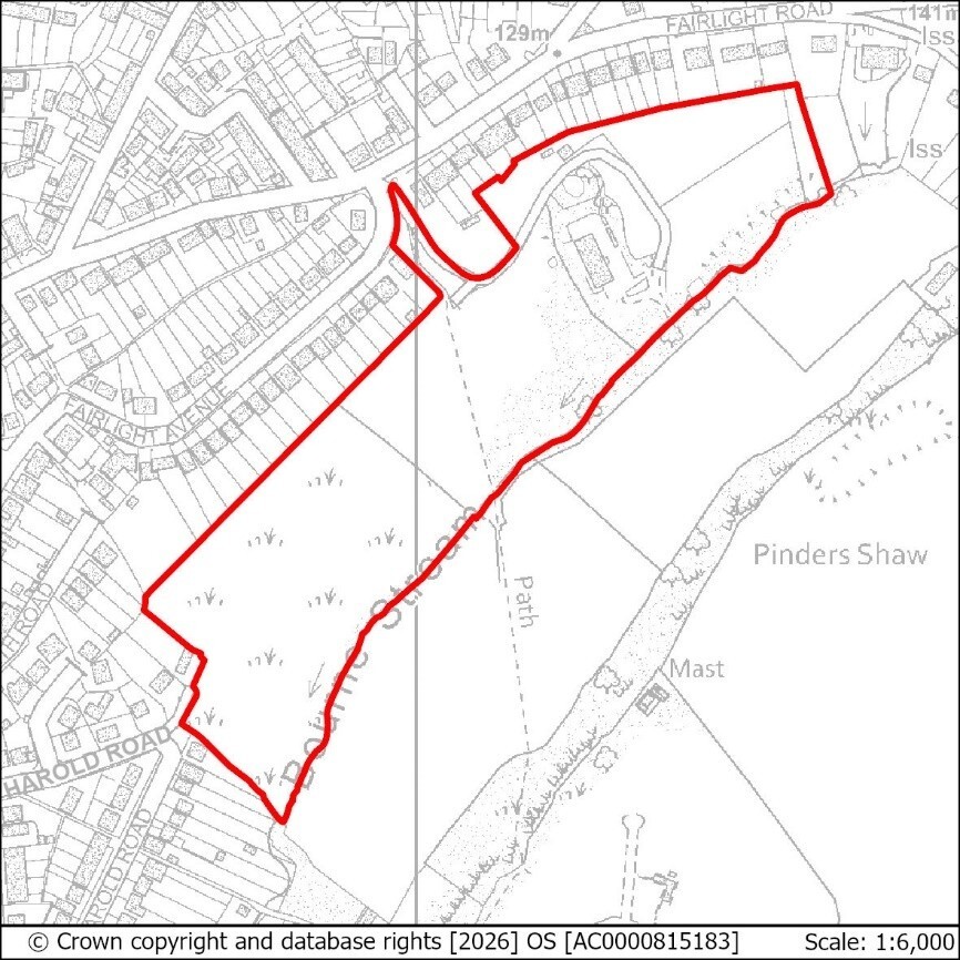
Figure 19: Land at Tilekiln Farm.
HS18: Land at Tilekiln Farm
Use: Residential
SHELAA Reference: HL148
Minimum Indicative Capacity (net additional dwellings): 75
Site Area (gross): 6.29ha
Site Area (net developable area): 4.19ha
Proposals for Development on this site should:
- Demonstrate a landscape-led approach to design and layout, which should follow the advice in the High Weald AONB Housing Design Guide.
- Retain, enhance and provide appropriate boundary treatments and landscaping with proposed built development enclosed within new strong buffers to define boundaries and soften visibility of existing rooflines from the valleyside. A suitable buffer to the woodland belt along the Bourne Stream and other vegetated belts within the site should be incorporated.
- Provide an Arboriculture Plan that demonstrates how existing trees on site will be integrated into the development, or their loss will be compensated for including the existing tree belts alongside the Bourne Stream.
- Provide a lighting plan for both the construction and occupation phases of the proposed development, with regard to the High Weald National Landscape Dark Skies TAN. The plan should include measures to prevent overspill from internal lighting. The lighting plan must be agreed before permission is granted.
- Provide affordable housing in line with Policy SP2.
- Secure a minimum of 1/3 of the site as public open space in perpetuity in a form which is characteristic of the National Landscape setting. This will be secured by legal agreement.
- Incorporate natural, unfenced multifunctional play space within the site.
- Include a maintenance and management plan for areas of publicly accessible open space and play.
- Include a Flood Risk Assessment (FRA) and drainage strategy taking into account all sources of flooding, local ground conditions, the presence of surface water drains and be informed by appropriate hydrological monitoring. The FRA and its recommendations must demonstrate that the proposal will be safe from flooding for its intended lifetime taking into account climate change, residual risk and the functional role of the floodplain. It should take into account the results of an agreed programme of hydrological and groundwater monitoring, seek to improve the flow rate of the Bourne Stream during heavy rainfall and reduce the overall risk of flooding in residential areas downstream, including through Natural Flood Management Measures.
- Apply a sequential approach to proposed development within the site following the recommendations of the FRA, directing more vulnerable development away from areas with highest risk.
- Provide a drainage strategy that is supported by a maintenance and management plan to ensure SuDS will be managed for the lifetime of the development. This plan must be presented as a standalone document. Where any new, retained or improved flood mitigation or adaptation measures are included within the development an additional standalone maintenance and management plan for these elements must be produced.
- Incorporate measures to preserve and enhance water quality by preventing pollutants from entering the Bourne Stream, such as the use of interceptors.
- Incorporate riparian buffer zones around the Bourne Stream (10m), including any necessary allowances for climate change. Provide easements to allow monitoring of the Bourne Stream.
- Be supported by an Ecological Impact Assessment (EcIA) and include an Ecological Constraints and Opportunities Plan (ECOP) and incorporate appropriate conservation and mitigation measures as recommended by the EcIA. The ECOP must make specific reference to the Bourne Stream, Hastings Cliffs to Pett Beach SSSI and High Weald National Landscape, the results of site surveys of HS18 itself, and to other nearby areas of wildlife sensitivity. The assessment must take into account any additional recreational impacts that may result from the proposal during all phases of development.
- Assessments of BNG must be informed by a River Condition Assessment of the Bourne Stream.
- Include a Historic Environment Record (HER) informed desk-based assessment of potential interests within an Archaeological Notification Area and agree to an appropriate programme of archaeological investigation secured by condition/s prior to any development works (as advised by ESCC).
- Be informed by a Transport Assessment and Travel Plan, following a vision led approach, and including a provision for ‘monitor and manage’ for transport interventions, particularly in relation to any requirements for mitigation in relation to Fairlight Road and the A259. The active travel element should include walking and cycling links to ensure local connectivity including to local community infrastructure, green spaces and public transport provision.
- Retain and enhance the PROW within the site, and support active travel connections to the wider walking and cycling network and key transport hubs including Ore Village Local Centre.
- Ensure vehicular access to the site meets appropriate highways standards.
- Be informed by agreed land stability and geotechnical reports covering the temporary and permanent condition of the site taking into account all dead and imposed loads.
- Include a maintenance and management plan for any new, retained or improved land stability mitigation measures to ensure they will be safe for their intended lifetime.
Policy HS20: Former West Hill Road Reservoir Comment
6.99The former West Hill Road Reservoir is a former Water Board site unused since 1927 on the North side of West Hill Road. There are structures remaining on the site including a front reservoir, a single aspect derelict brick pump house with a flat roof, the original Victorian waterworks cottage, and the rear reservoir chambers. Due to its former use there is a potential for some element of pollution to be present.
6.100The earth-mounded front reservoir forms part of the concrete retaining wall running parallel to West Hill Road and site investigation will be required to determine how to safely remove or remediate the front structures without causing ground movement or landslide within the surrounding areas.
6.101The rear chambers consist of two vast brick-lined, earth-mounded and vaulted tanks with an internal height of about 5 metres. The roof has a row of ventilators visible from the outside within a largely grassed area.
6.102The pumping house is a mono-aspect flat roofed structure in the centre of the site, and together with the Victorian-style waterworks cottage will require demolition or incorporation into any scheme. The site is ineligible for vacant building credit due to the poor condition of the structures.
6.103The topography of the site is obscured by the structures in place within it, which at present result in a stepped site rising South-North. There is potential for the site to be remediated to a predominately flat or gently sloping topography, provided suitable engineered solutions are agreed.
6.104The site will require a full and detailed land stability assessment covering the temporary (during demolition and construction), intermediate (following removal of structures) and permanent (post development) condition of the site. The development of the site may need to be phased accordingly. It is recommended that these reports also take into account drainage design and any potential for pollution.
6.105The site is within the Grosvenor Gardens Conservation Area and there is a bus stop to the South of the site which should be retained and potentially improved by any proposed scheme.
6.106The site contains non-designated heritage assets, and no demolition should take place until the existing structures and buildings have been recorded.
6.107The site is in an overgrown condition with scrubby coverage throughout and will require an Ecological Constraints and Opportunities Plan (ECOP) and any proposal must also be informed by an Ecological Impact Assessment (EcIA). Assessments must take into account any nearby areas of wildlife sensitivity and the site itself should be thoroughly surveyed to identify constraints, taking into account the ecological and recreational impact of development. Any development proposal must seek to avoid or minimise impact on ecologically sensitive areas during both the construction and occupation phases of the development.
Figure 20: Former West Hill Road Reservoir
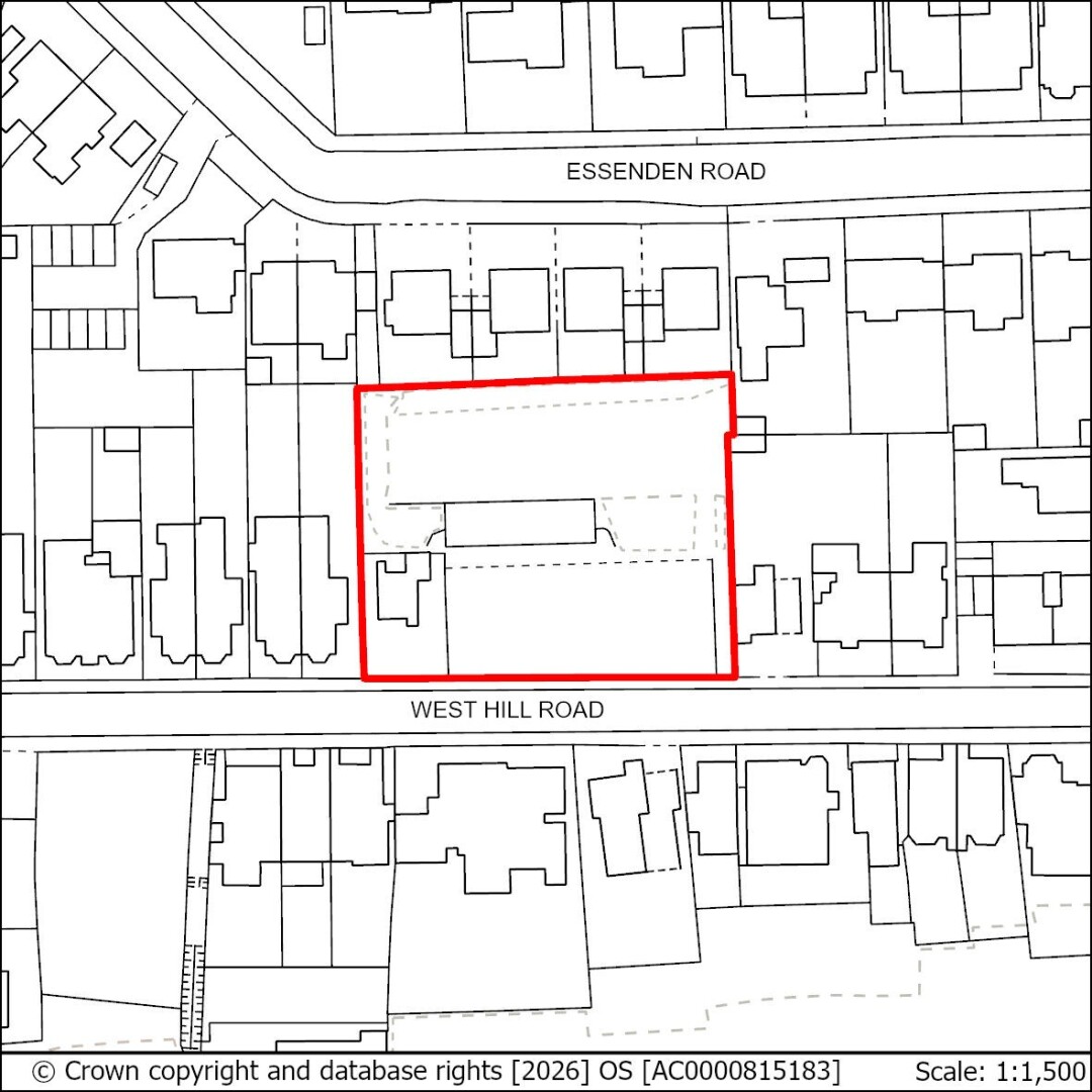
HS20: Former West Hill Road Reservoir
Use: Residential
SHELAA Reference: HL151
Minimum Indicative Capacity (net additional dwellings): 30
Site Area (gross): 0.21
Proposals for Development on this site should:
- Provide affordable housing in line with Policy SP2.
- Be informed by agreed land stability and geotechnical reports covering the temporary, intermediate and permanent condition of the site, taking into account all dead and imposed loads.
- Include a maintenance and management plan for any new, retained or improved land stability mitigation measures to ensure they will be safe for their intended lifetime.
- Retain and enhance or reprovide the bus stop to the South of the site.
- Avoid unacceptable harm or loss to the significance and setting of the Grosvenor Gardens Conservation Area.
- Acknowledge that no demolition shall take place on the site until the existing structures and buildings have been recorded in line with relevant Historic England Guidance. This will be secured by condition.
- Provide appropriate evidence of a vision led and validate approach to transport impacts of the development, to include walking and cycling links to ensure local connectivity to key transport hubs including West St Leonards Station and National Cycle Route 2.
- Ensure vehicular access to the site is attained from West Hill Road and meets appropriate highways standards.
- Be supported by an Ecological Impact Assessment (EcIA) and Ecological Constraints and Opportunities Plan (ECOP), and incorporate appropriate conservation and mitigation measures as recommended by the EcIA. The ECOP must make specific reference to the nearby Caves Road Cliffs Local Wildlife Site, the results of site surveys, and to other nearby areas of wildlife sensitivity.
Policy HS21: Land East of Rock Lane Comment
6.108Land East of Rock Lane is a 1.72ha site that straddles the Hastings – Rother administrative boundary. Approximately 0.72ha is within Hastings. The site is a part brownfield site with an existing access road and areas of dense vegetation.
6.109The site shares a south-eastern boundary with site HS13, however a sharp difference in levels and an established drainage ditch and tree belt prevent the two sites from sharing significant transport infrastructure. However, there is potential for a pedestrian and cycle link connecting both sites to provide access to local schools, sports facilities and services in the vicinity of Rye Road.
6.110The site is within the High Weald National Landscape (AONB) and therefore a sensitive form of development is required in line with Local Plan policies.
6.111The site will require an Ecological Constraints and Opportunities Plan (ECOP) and any proposal must also be informed by an Ecological Impact Assessment (EcIA). Assessments must make specific reference to the High Weald National Landscape and take into account any nearby areas of wildlife sensitivity and the site itself should be thoroughly surveyed to identify constraints, taking into account the ecological and recreational impact of development. Any development proposal must seek to avoid or minimise impact on ecologically sensitive areas during both the construction and occupation phases of the development.
6.112The site slopes north south and an appropriate assessment of land stability should be provided. Proposals should seek to incorporate existing surface water management measures such as the drainage channels to the north and east of the site into any proposed Sustainable Drainage Systems (SuDS).
6.113Due to the overall area of the site, a Flood Risk Assessment will be required.
6.114Vehicle access to the site must be from Rock Lane in neighbouring Rother District, and any proposal should be accompanied by a Transport Report, prioritising sustainable and multimodal transport options, within a vision led and validate approach.
Figure 21: Land East of Rock Lane.
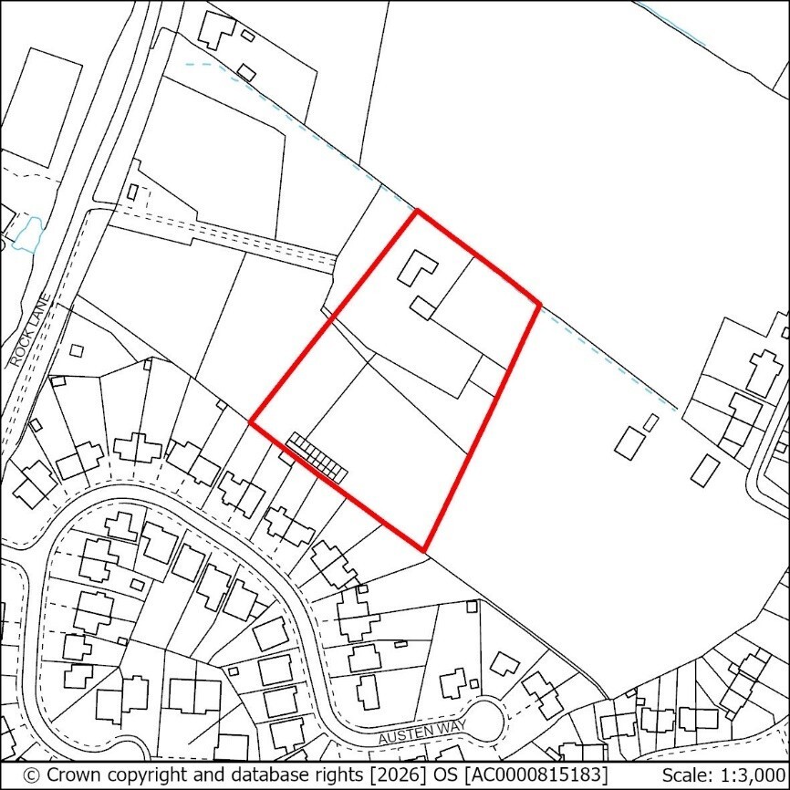
HS21: Land East of Rock Lane
Use: Residential
SHELAA Reference: HL153
Minimum Indicative Capacity (net additional dwellings): 20
Site Area (gross): 0.72ha (1.72ha total)
Proposals for Development on this site should:
- Demonstrate a landscape-led approach to design and layout, which should follow the advice in the High Weald AONB Housing Design Guide;
- Provide affordable housing in line with Policy SP2;
- Be informed by agreed land stability and geotechnical reports;
- Allow for a comprehensive scheme that incorporates the adjoining land within the Rother District Council administrative area;
- Safeguard the Dark Skies of the High Weald National Landscape in line with the Dark Skies Technical Advice Note
- Be supported by an Ecological Impact Assessment (EcIA) and Ecological Constraints and Opportunities Plan (ECOP), and incorporate appropriate conservation and mitigation measures as recommended by the EcIA. The ECOP must make specific reference to the High Weald National Landscape, the results of site surveys, and to other nearby areas of wildlife sensitivity.
- Incorporate foot and cycle path connectivity to Winchelsea Lane and Rye Road;
- Ensure vehicular access from Rock Lane to the site meets appropriate highways standards;
- Provide appropriate transport evidence, setting out a clear vision led approach for sustainable and multimodal transport, and an appropriate regime for managing and monitoring the impacts of development to identify whether further transport interventions are necessary.
- Take account of Southern Water's underground infrastructure in the design of the site layout. Easements would be required, which may affect the site layout or require diversion, and these should be clear of all proposed buildings and tree planting;
- Be supported by a Flood Risk Assessment and detailed Drainage Strategy;
- Provide an Arboriculture Plan that demonstrates how existing trees on site will be integrated into the development, or how compensation will be made for their loss.
Policy HS23: Land East of Beaneys Lane, The Ridge Comment
6.115Land East of Beaneys Lane is a 7.60ha site that straddles the Hastings – Rother administrative boundary. Approx. 0.40ha is within Hastings.
6.116The site is within the High Weald National Landscape (AONB) and therefore a sensitive form of development is required in line with Local Plan policies.
6.117Although the Hastings’ portion is relatively flat, the portion of the site that sits within Rother District undulates and then slopes steeply to the north within the northernmost area. Proposals should be supported by an appropriate land stability report for both the temporary (during construction) and permanent (occupation) condition of the site that includes mitigations where appropriate.
6.118Due to the overall area of the site, a Flood Risk Assessment will be required taking into account both the site itself and the potential for impacts downstream. The site includes two areas of watercourse and proposals should seek to incorporate suitable SuDS measures.
6.119The site will require an Ecological Constraints and Opportunities Plan (ECOP) and any proposal must also be informed by an Ecological Impact Assessment (EcIA). Assessments must make specific reference to the High Weald National Landscape, SSSI Impact Risk Zones and nearby Ancient Woodland and take into account any nearby areas of wildlife sensitivity and the site itself should be thoroughly surveyed to identify constraints, taking into account the ecological and recreational impact of development. Any development proposal must seek to avoid or minimise impact on ecologically sensitive areas during both the construction and occupation phases of the development.
6.120There are TPOs at the southern boundary of the site, which should be retained as part of any proposed scheme. Trees and woodland within the site should be retained to provide connectivity to an area of Ancient Woodland to the North of the site.
6.121Vehicle access to the site must be from The Ridge, and any proposal should be accompanied by a Transport Report, including sustainable and multimodal transport options.
Figure 22: Land East of Beaneys Lane.
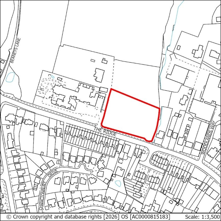
HS23: Land East of Beaneys Lane, The Ridge
Use: Residential
SHELAA Reference: HL144b
Minimum Density Range: 45 - 55 dwellings per hectare
Minimum Indicative Capacity (net additional dwellings): 18
Site Area (gross): 0.40ha (7.60ha total)
Proposals for Development on this site should:
- Provide affordable housing in line with Policy SP2;
- Be informed by agreed land stability and geotechnical reports for both the temporary and permanent condition of the site;
- Allow for a comprehensive scheme that incorporates the adjoining land within the Rother District Council administrative area;
- Incorporate opportunities for active and multimodal travel;
- Ensure vehicular access to the site from The Ridge meets appropriate highways standards.
- Provide appropriate transport evidence, setting out a clear vision for sustainable and multimodal transport, and an appropriate regime for monitoring the impacts of development to determine whether further transport interventions are necessary.
- Be supported by a Flood Risk Assessment and detailed Drainage Strategy.
- Be informed by a landscape sensitivity assessment to determine an appropriate layout, form and detailed design to ensure the conservation and enhancement of the landscape and character of the High Weald National Landscape.
- Be informed by ecological and hydrological survey work which demonstrates development will have no adverse impact on the integrity of the Maplehurst Wood SSSI;
- Be supported by an Ecological Impact Assessment (EcIA) and Ecological Constraints and Opportunities Plan (ECOP), and incorporate appropriate conservation and mitigation measures as recommended by the EcIA. The ECOP must make specific reference to the nearby Ancient Woodland, High Weald National Landscape and SSSI Impact Risk Zones as well as the results of site surveys, and to other nearby areas of wildlife sensitivity.
- Assess the ecological impact of the proposed development, including through an Arboriculture Plan that demonstrates how existing trees on site will be integrated into the development, or how compensation will be made for their loss demonstrating that the proposal has been designed to maximise retention of connectivity to the Ancient Woodland to the North.
Policy HS25: Former Convent of Holy Child Jesus, Magdalen Road Comment
6.122This 4.76ha former Convent is a nationally important heritage site. It contains a unique collection of Grade II listed buildings and a Grade II* listed chapel, in an enclosed landscaped setting. The Convent complex is situated in a clifftop location and as a result there is a high degree of visibility from within the site to other parts of the Borough, out to sea, and corresponding townscape views from other parts of the Borough towards the site. The site sits within the Magdalen Road conservation area.
6.123This is a complex site and a Masterplan and Development Brief is needed to understand and identify the quantum and form of any new development required to secure the future of the listed buildings and to deliver a viable and sustainable scheme for the site as a whole in terms of its heritage value. The council has worked with Historic England and the current site owners to develop a Masterplan and Development Brief for the site, located at Annex 1.
6.124The site has been vacant for a number of years and is in a deteriorating condition. A condition survey prepared in support of the Masterplan and Development Brief for the site identifies the need for significant repair and restoration of the buildings, as well as the need for their long-term management.
6.125Development proposals for this site must secure the repair, restoration and long-term sustainable future of the Convent buildings. In addition, given the historic sensitivity of the site and its high visibility in the wider townscape, development proposals must be heritage led and based on a thorough understanding of the significance of the buildings and the surrounding landscape and any heritage features within it.
6.126The site is allocated for a residential-led scheme with an indicative capacity of 200 dwellings, which includes conversion of some of the listed buildings together with new build development and would be subject to the approval of detailed designs at the application stage.
6.127Owing to the complexities of the site, any planning application submitted must be a Full planning application and must align with the principles set out in the Masterplan and Development Brief. Any planning application submitted in outline, or which does not present a comprehensive proposal for the whole site, will not be supported.
6.128Whilst the allocation is residential-led, consideration will be given to an alternative masterplan or development brief, provided it robustly demonstrates how it will secure the restoration and long-term reuse of the heritage assets, secure public benefits, and provide a comprehensive scheme for the regeneration of the whole site.
6.129The Local Planning Authority will liaise closely with Historic England on any scheme submitted including the sharing with them of viability or financial assessments submitted to support development proposals.
Figure 23: Former Convent of Holy Child Jesus, Magdalen Rd
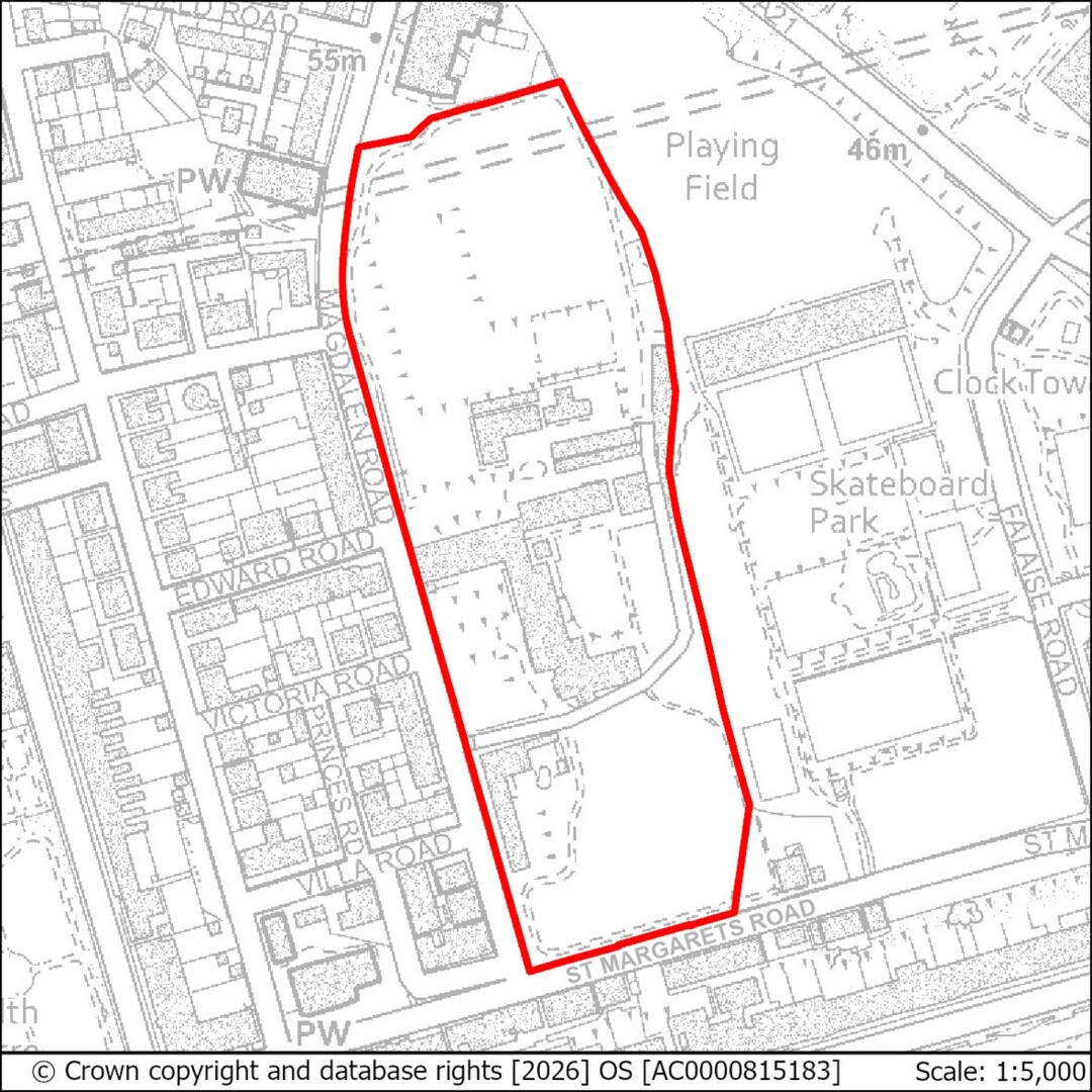
HS25: Former Convent of Holy Child Jesus, Magdalen Road
Use: Residential-led Heritage regeneration
Indicative Capacity: 200 dwellings
Site Area (gross): 4.76ha
The Former Convent of the Holy Child Jesus site is allocated as a comprehensive heritage, landscape and residential-led regeneration scheme. Development must secure the repair, restoration, active re-use and long-term management of the Grade II* listed chapel, Grade II listed buildings, curtilage listed structures and protection of the Nuns’ Cemetery, a non-designated heritage asset.
Proposals for Development on this site will be supported in principle subject to the criteria set out below:
- Any Development must be brought forward comprehensively across the entire site by way of a Full planning application and must align with the principles set out in the Masterplan and Development Brief at Annex 1. Outline or hybrid planning applications will not be supported;
- Proposals must define the full extent of development from the outset, including heritage works, demolition, phasing, layout, scale, access, landscaping, viability, public benefits, long-term management and delivery mechanisms. These will be secured through a legal agreement or other enforceable mechanism;
- Development must be supported by the following:
- Heritage Impact Assessment
- Building Condition Survey
- Conservation Management Plan
- Schedule of repair and restoration works
- Phasing and delivery plan
- Viability assessment demonstrating how development secures the heritage objectives
- Landscape and visual impact assessment
- Arboricultural assessment
- Sustainable drainage strategy
- Access, movement and parking strategy
- Long-term stewardship and management plan
- The Grade II* listed chapel shall be sensitively restored and brought back into use, the nature of which should be compatible with its significance, spatial qualities and setting. Any proposal should maximise opportunities for managed public access and heritage interpretation, where this aligns with its proposed operation and long-term use;
- Any proposal for conversion and reuse of the Grade II listed buildings, which may include residential, cultural, community, educational, workspace, later living or other appropriate uses, must ensure that their significance is conserved and enhanced and that their long-term use and public benefit is secured;
- The repair, restoration and reuse of the listed buildings must be secured as early as possible in the development process. The occupation and/or completion of new-build residential development must be linked to the completion of agreed heritage works, via the use of planning condition, legal agreement or other enforceable mechanism
- The Nuns’ Cemetery, which has been identified as a non-designated heritage asset, must be protected as a respectful landscape feature. The cemetery and any land with potential for burials, including unmarked lay burials, must be protected from development and disturbance wherever practicable. The Historic Environment Record should be consulted and archaeological field investigations carried out where appropriate, in accordance with an approved Written Scheme of Investigation
- Clear justification must be provided for the layout, form, scale and massing of development and how this relates to the heritage significance of the site, including its setting, topography, viability and the requirement to secure the restoration and long-term conservation of the heritage assets
- Any proposals must preserve and where possible enhance the character and appearance of the Magdalen Road Conservation Area, including protecting the setting of any designated, or non-designated, heritage assets affected by the proposals
- Development must be of a high-quality design and layout, be locally distinctive, and use contextual materials and forms which respond positively to the site’s historic, townscape and landscape context.
- The overall scheme must provide a connected landscape, comprising restored historic gardens, ecological enhancements, gardens, sustainable drainage, play provision, open space and safe and legible pedestrian and cycle links to adjoining areas
- Landscape features, mature trees and existing boundary planting must be retained where practicable. Where any of these features are negatively impacted, clear justification must be provided, setting out how such impacts are to be minimised, mitigated and compensated for, as part of the overall landscape strategy
- The proposal is accompanied by appropriate environmental assessments that take into account its location within the ACIB with mapped measures for improvement;
- Development proposals must respond to the three character areas identified in the Masterplan and Development Brief as follows:
Northern Area
- Landscape-led residential development arranged around gardens, prioritising pedestrian routes and communal spaces. Layout, massing, scale and grain must align with that of the adjacent Magdalen Rd and must respond to site topography, retain existing mature trees and preserve the Nuns’ Cemetery
Central Area
- Prioritisation must be given to the repair, conservation and adaptive re-use of the Grade II* listed chapel, the Grade II listed Former Convent buildings and gardens. Any new development must preserve and enhance the character and coherence as a former convent complex, maintaining important views, garden settings and relationships with the chapel
Southern Lawn
- Development must be peripheral and must retain and enhance the role of the lawn, a significant open landscape space that is essential to the setting, significance and legibility of the convent complex. Key views to the Training College and Grade II* listed chapel must be protected and any new buildings must be subordinate to the heritage assets and landscape setting
- Any proposal which would prejudice the comprehensive delivery of the site as a whole, including the restoration and reuse of the listed buildings, the long-term management of the site, or the delivery of public benefits, will not be supported.
Policy HS26: Site of Four Courts, Stonehouse Drive Comment
6.130This is a 4.4ha site comprising 381 dwellings across four tower blocks (each one 18 storeys): Bevin Court, Kennedy Court, Roosevelt Court and Churchill Court. Within the site there is also a community centre, a nursery, three 2 storey terraces and two semi-detached bungalows, and a limited amount of parking.
6.131Developed in the 1960s, the existing high-rise blocks have numerous deficiencies which the landowner wishes to address through a comprehensive renewal scheme.
6.132The site is allocated for a minimum of 450 dwellings gross, with higher densities being encouraged. Development on the site should be apartment-led, seeking to maximise the established high-density nature of the site.
6.133Comprehensive renewal of the site provides an opportunity to increase housing provision, improve the quality and accessibility of the accommodation and to create a more attractive and better-connected public realm.
6.134Redevelopment of the site should concentrate not only on the replacement and increase of the number of housing units on the site, but also on providing substantial community infrastructure, including central open space, play space, landscaping, biodiversity gains and connectivity, both within the site and through to the wider environs beyond.
6.135Development should be apartment-led, with dwellings of varying size and layout, in order to maximise the area of central open space. Alternative schemes will be considered provided that they are design-led and include substantial central open space.
6.136The community centre and nursery are important community facilities and should be retained, or, if demolished as part of a comprehensive redevelopment scheme, be replaced with facilities of at least equivalent function. Replacement should seek to improve the level of provision in terms of quality, accessibility and useability and any period of time where community facilities will not be available to occupiers should be as minimal as possible.
6.137The site consists of a varied and sloping topography. The design of any scheme should seek to utilise the landform to help positively shape the layout and built form. Proposals will need to demonstrate how access routes, pedestrian and vehicular movements, drainage and parking effectively utilise the changes in levels on the site. Consideration should be given to reducing the need for cut and fill, significant retaining structures and major engineering works.
6.138The Hollington Stream runs alongside the boundary of this site. A limited portion of the site is in Flood Zone 3b, and a Flood Risk Assessment taking into account all potential sources of flooding will be required and mitigation as advised by the report should be incorporated into any potential scheme and maintained for its lifetime, with a sequential approach taken to ensure compatibility of scheme elements with the level of flood risk. The Hollington Stream is an important ecological asset and is also engineered to avoid unacceptable flood risk so close working with the council and the Environment Agency is encouraged. Safe access and exit for all residents must be provided.
6.139Adequate buffer zones should be incorporated into any proposal that takes into account riparian zones, the impacts of climate change on flood risk, BAP Priority Habitat (deciduous woodland) to the west of the site and Southern Water’s infrastructure to the south-east. Natural Flood Management Measures, such as floodplain restoration, may be appropriate within this site. Easements should be provided to allow the monitoring of water quality.
6.140The site is adjacent to the Ponds Wood Local Nature Reserve and Local Wildlife Site. The LWS and the Hollington Stream must be specifically referenced in Ecological Impact Assessments (EcIA) and Ecological Constraints and Opportunities Plan (ECOP), and the site itself should be thoroughly surveyed to identify constraints, taking into account the ecological and recreational impact of development. The BNG assessment must include a River Condition Assessment.
Figure 24: Site of Four Courts, Stonehouse Drive
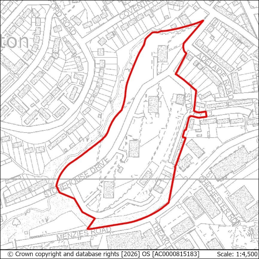
HS26: Site of Four Courts, Stonehouse Drive
Use: Residential-led Renewal
Minimum Capacity: 450 dwellings (gross) 64 dwellings (net)
Site Area (gross): 4.44ha
Proposals for development on this site should:
- Deliver a comprehensive apartment-led renewal scheme, making best use of the established high-density residential location by providing a minimum of 450 dwellings;
- Demonstrate a high quality of design, make efficient use of the site, provide an appropriate mix of dwelling sizes;
- Ensure the existing community centre and nursery are retained or, as part of the comprehensive redevelopment of the site, replaced with enhanced provision, including outdoor play space for the nursery;
- Create a distinctive neighbourhood oriented around a centrally located area of substantial open space, forming the focus of the development, providing opportunities for recreation, biodiversity enhancement and sustainable drainage;
- Provide high-quality, accessible, well designed and overlooked play provision, integrated within the central open space as well around the wider site, including equipped play and opportunities for doorstep play;
- Make best use of the site’s topography to positively inform design, scale, layout and massing.
- Be supported by appropriate technical assessments and mitigation measures, including where necessary:
- A flood risk assessment addressing all sources of flooding and a drainage strategy with specific reference to the Hollington Stream;
- An Ecological Impact Assessment and Ecological Constraints and Opportunities Plan informed by surveys of the site itself and nearby areas of wildlife sensitivity including Ancient Woodland, Hollington Stream, Ponds Wood Local Nature Reserve and Local Wildlife Site. The site sits within the ACIB with mapped measures for buffer strips along rivers and streams which should likewise be incorporated into the reports. A River Condition Assessment will be required to inform assessments of BNG;
- An arboricultural assessment;
- Land stability, groundwater and geotechnical investigations to inform the demolition, construction and occupation phases;
- A Visual Impact Assessment, demonstrating how the scale, massing and roofscape of the development responds to the surrounding townscape and wider views;
- Provide safe and legible pedestrian and cycle routes throughout the site, linking with existing external networks.
- Parking provision, including secure cycle storage, should respond to the proposed dwelling mix and be incorporated into building design and layout, reducing impact on the public realm and open space provision.
- Include arrangements through legal agreement, for the long-term management and maintenance of the public open space, landscaping, ecological features and community facilities and any land stability mitigation measures;
- As part of any required Site Waste Management Plan, which deals with construction, demolition and excavation waste, include an Operational Waste Management Plan. This should set out the location and design of integrated waste and recycling storage, collection points, servicing and management arrangements.
Policy HS27: My Way Lodge, The Ridge West Comment
6.141My Way Lodge is a 1.29ha site close to the borough boundary in north west Hastings. It is currently occupied by an extended 20th Century home, a number of outbuildings and its garden. The site shares a boundary to the west with the Beauport Park holiday village and to the south with The Ridge West.
6.142The site sits within the High Weald National Landscape and any scheme should be landscape-led and take into account the advice and guidance set out within the High Weald AONB housing design guide. In order to mitigate landscape impacts, reduce noise transfer to and from surrounding areas and manage pollution from The Ridge West appropriate boundary treatments and tree buffers should be incorporated. As the agent of change, the scheme should not prejudice the operation of the Beauport Park holiday village nor allow negative impacts arising from the presence of the village to result in a poor standard of amenity of the eventual occupiers of the My Way Lodge site.
6.143The site is within the Beauport Park Local Wildlife site and the ACIB, and will require appropriate ecological assessments. Assessments should make reference to surveys of the site itself, the ACIB, the adjacent APIB and the Beauport Park Local Wildlife Site, as well as any other nearby areas of wildlife sensitivity. Due to the location in the HWNL and the presence of wildlife sensitive areas, a lighting plan following the advice of the High Weald National Landscape Dark Skies TAN should be provided for all phases of development demonstrating how light spill will be prevented or mitigated.
6.144There is a deficiency of access to open space and play in this location. In order to ensure future occupiers have appropriate access to open space and play, development should be confined to an approximately 0.5ha area to the west of the site that is currently occupied by the main dwelling, areas of hardstanding and other ancillary structures. The remainder of the site, net of any areas required for SuDS and other ecological obligations should form public open space for the development, and incorporate equipped or structured play space, either fenced or unfenced. A row of WWII anti-tank blocks run along the northern boundary, and schemes that leave these blocks in situ and incorporate them into a unique public realm response will be encouraged. Advice should be sought at an early stage regarding any appropriate asset recording.
6.145The site currently benefits from multiple vehicle accesses to The Ridge West, and a transport assessment and plan should demonstrate whether these may be brought up to an acceptable standard or whether a new access would be required.
6.146In accordance with other policies of this plan and National Planning Policy, schemes must not restrict or otherwise inhibit the upsizing, access or operational functionality of the nearby utilities sites to the south of The Ridge West.
Figure 25: My Way Lodge, Ridge West
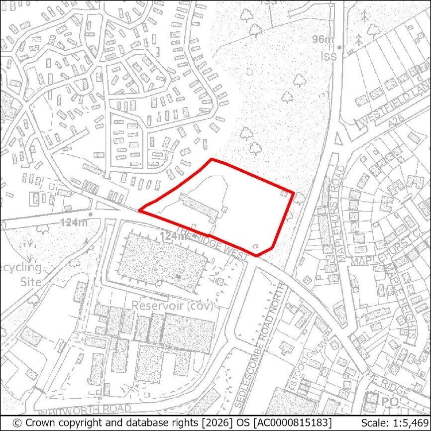
HS27: My Way Lodge, The Ridge West
Use: Residential
Minimum Indicative Capacity: 20 dwellings
Site Area: 1.29 (0.5ha net developable area)
Proposals for Development on this site should:
- Clearly demonstrate a landscape-led approach to design and layout, which should follow the advice in the High Weald AONB Housing Design Guide;
- Retain, enhance and provide appropriate boundary treatments and landscaping, incorporating 15m buffers to existing tree belts;
- Provide an Arboriculture Plan that demonstrates how existing trees on site will be integrated into the development, or their loss will be compensated for;
- Provide a lighting plan for both the construction and occupation phases of the proposed development, with regard to the High Weald National Landscape Dark Skies TAN. The plan should include measures to prevent overspill from internal lighting. The lighting plan must be agreed before permission is granted;
- Provide affordable housing in line with Policy SP2;
- Secure the undeveloped, eastern half of the site as public open space incorporating natural, unfenced multifunctional play space in a form which is characteristic of the National Landscape setting. This open space and play provision must be secured in perpetuity, to be secured by legal agreement;
- Include a maintenance and management plan for areas of publicly accessible open space and play;
- Be supported by an Ecological Impact Assessment (EcIA) and include an Ecological Constraints and Opportunities Plan (ECOP) and incorporate appropriate conservation and mitigation measures as recommended by the EcIA. The ECOP should make specific reference to the High Weald National Landscape, the Beauport Park Local Wildlife Site, surveys of the site itself and any other nearby areas of wildlife sensitivity. Opportunities for enhancement should have regard to the LNRS and should include an ecological management plan;
- Provide a sewer connection at the nearest point of sufficient capacity;
- Be supported by a Transport Report. Proposals must also indicate how the conclusions and recommendations of the Report have been incorporated within the development;
- Provide connections to the wider walking and cycling network and key transport hubs including Battle Station in neighbouring Rother;
- Ensure vehicular access to the site from The Ridge West meets appropriate highways standards;
- Must not prejudice the current or future use of the neighbouring holiday park during either the construction or occupation phases of development. Should there be any need to mitigate adverse impacts, the cost of this should be borne by the agent of change prior to completion of development. This will be secured by condition;
- Seek to incorporate non-designated heritage assets along the northern boundary of the site into the wider public realm.
Policy HSS5: Land at Chiltern Drive Comment
6.147Land at Chiltern Drive is a smaller site at the corner of Chiltern Drive and Southdown Avenue. It is both steeply sloping and has a mix of levels within the site. The site includes a terrace of pent roof bungalows to the south that should either be demolished or incorporated into any site proposal.
6.148The site is crossed by overhead distribution lines linking the Ridge Primary Electricity Substation and the Hastings Main Electricity Substation on Ore Valley Road. Any scheme should either provide the necessary clearances for the powerlines or consider relocating them underground to remove height and working restrictions imposed by their presence. Appropriate easement to maintain the assets should be agreed with the electricity board.
6.149The site is adjacent to the Broomgrove Local Wildlife Site and it is essential that any development is informed by an EcIA as well as an ECOP.
6.150Due to the site topography and the topographical character of the surrounding area, the site will require a full and detailed land stability assessment covering the temporary (during site preparation and construction) and permanent (post development) condition of the site.
6.151Proposals will need to consider and be informed by the need to resist ground movement and deformations during all project phases in order to protect the integrity of nearby dwellings and those already present onsite if retained. It is recommended that ground investigations also take into account drainage design and any potential for contamination.
6.152Relevant ecological assessments will be required, including recommendations for any necessary translocation, habitat creation or restoration within the site.
Figure 26: Land at Chiltern Drive
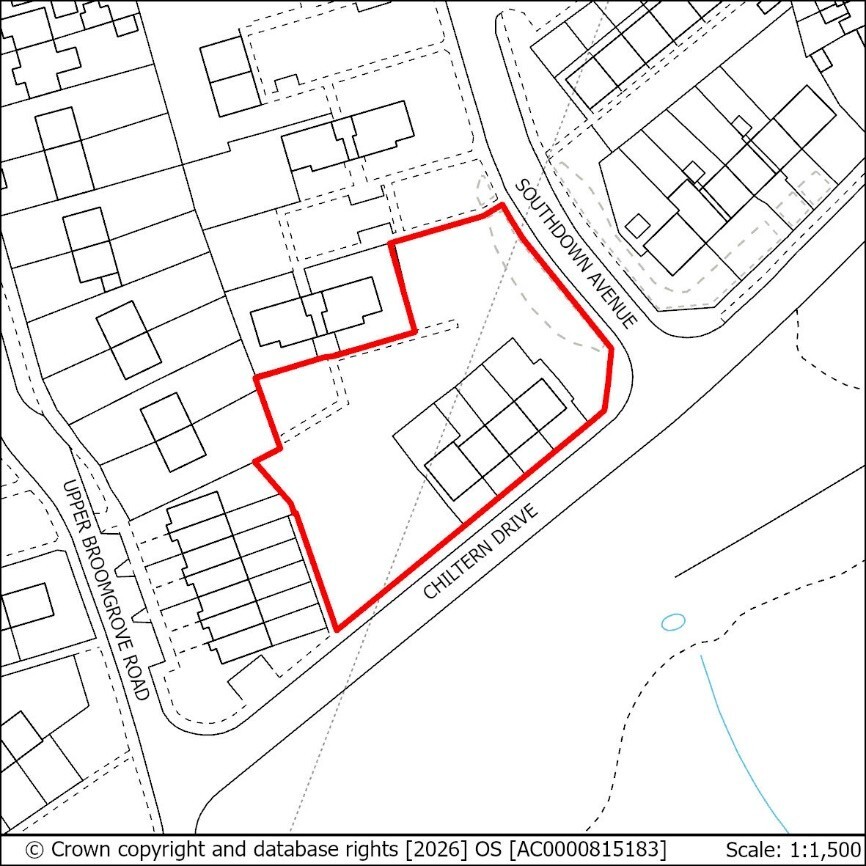
HSS5: Land at Chiltern Drive
Use: Residential
SHELAA Reference: HL100
Minimum Indicative Capacity (net additional dwellings): 13
Site Area (gross): 0.24
Proposals for Development on this site should:
- Provide affordable housing in line with Policy SP2;
- Be informed by agreed land stability and geotechnical reports covering the temporary and permanent condition of the site, taking into account:
- all dead and imposed loads, and;
- the need to protect the integrity of adjacent buildings;
- Include a maintenance and management plan for any new, retained or improved land stability mitigation measures to ensure they will be safe for their intended lifetime;
- Be informed by an EcIA and include an ECOP. The ECOP must make specific reference to the Broomgrove Local Wildlife Site;
- Include walking and cycling links to ensure local connectivity to key transport hubs including Ore Railway Station;
- Ensure vehicular access to the site meets appropriate highways standards;
- Take account of Southern Water's underground infrastructure in the design of the layout of the site. Easements would be required, which may affect the site layout or require diversion, and these should be clear of all proposed buildings and tree planting
- Assess the ecological impact of the proposed development, including through an Arboriculture Plan that demonstrates how existing trees on site will be integrated into the development, or how compensation will be made for their loss.
Policy TP1: Land South of Crowhurst Road Comment
6.153The site is located at the junction of B2092 Crowhurst Road and A2690 Queensway. Queensway has connections to the wider road network, including the A2690 Combe Valley Way (leading to the A259 to Brighton) and the A21 (leading to London and the A259 to Ashford) Some access improvements are required. The site has sufficient space to comfortably accommodate at minimum no.2 pitches, associated berths and ancillary buildings.
6.154The site has a Local Wildlife Site and Ancient Woodland nearby. These areas must be specifically referenced in any Ecological Constraints and Opportunities Plan (ECOP), and the lighting plan must seek to minimise light spill to these and other areas of wildlife sensitivity. An arboriculture plan must also be provided to set out how existing trees will be either integrated into the proposal, or their loss will be compensated for. The ECOP, lighting plan and arboriculture plan can all form part of the same document if appropriate.
6.155The site has an established tree belt at the perimeter, and any scheme should seek to preserve and enhance this both for the ecological value and for the amenity benefits it can provide in terms of amenity by screening the site from the noise, emissions and lack of privacy that could result from a more open boundary with Queensway. Additionally, retention of boundary landscaping to the west of the site will also provide a buffer that can help mitigate any noise and disturbance from the nearby railway line.
6.156The site does not currently benefit from a sewerage connection, or suitable access to the highway. A sewer connection will be required for any utility block and must also be able to support the safe and easy disposal of any cassette waste holding tank contents from vehicles. Access to the site must be improved in line with the advice of the highway authority to provide safe access to and from the site for both residents and servicing.
6.157The site has minimal risk from surface water flooding. However, for the amenity of residents an appropriate SuDS system should be incorporated into any proposal. Such schemes should seek to preserve water quality by including any necessary mitigation measures.
Figure 27: Land South of Crowhurst Road
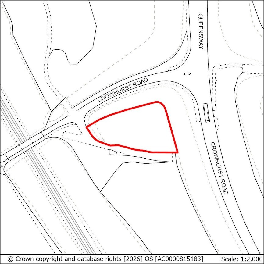
TP1: Land South of Crowhurst Road
Use: Permanent Site for Gypsies and Travellers
Minimum Indicative Capacity (pitches): 2
Sites Area: 0.17ha
Proposals for Development on this site should:
- Be supported by an Ecological Impact Assessment (EcIA) and include an Ecological Constraints and Opportunities Plan (ECOP) and incorporate appropriate conservation and mitigation measures as recommended by the EcIA. The ECOP must make specific reference to the presence of the nearby Ancient Woodland and Local Wildlife Site, and priority habitat within the site and make clear recommendations regarding the provision of appropriate buffers. Opportunities for enhancement should have regard to the LNRS and should include an ecological management plan;
- include a lighting plan to minimise light spill to nearby areas of wildlife sensitivity, including nearby Ancient Woodland and Local Wildlife Site;
- provide an Arboriculture Plan that demonstrates how existing trees on site will be integrated into the development, or how compensation will be made for their loss;
- retain and enhance existing landscaping to maintain an amenity and pollution buffer with Queensway and the nearby railway;
- include improvements to the access at the junction of Crowhurst Road and the Queensway as advised by the Local Highways Authority (East Sussex County Council).
- provide a connection to the sewerage system at the nearest point of adequate capacity, as advised by Southern Water and ensure future access to the existing sewerage and water supply infrastructure for maintenance and upsizing purposes.
- include an appropriate drainage plan to manage surface water and preserve water quality.
Policy TP2: Land at Tilekiln Lane Comment
6.158The site is located at the southernmost point of Tilekiln Lane in East Hastings, and an unadopted road accessed from Fairlight Road. Some access improvements may be required to facilitate vehicle access for both development and occupation of the site. The site has sufficient space to comfortably accommodate at minimum no.2 pitches, firebreaks, associated berths and ancillary buildings.
6.159The site is the location of the tile kiln for which the road is named and is in close proximity to the recorded entry points of the associated clay pits and sits within an Archaeological Notification Area (ANA). An appropriate programme of archaeological investigation will be essential.
6.160A belt of TPOs runs alongside the north-northwestern perimeter, and the site is in close proximity, and in some places adjacent, to the Hastings Country Park Local Wildlife Site, Hastings Country Park and Fairlight Place Farm Local Nature Reserve, and the High Weald National Landscape. It additionally sits within an impact risk zone for the SSSI. These areas must be specifically referenced in any Ecological Impact Assessment (EcIA) and Ecological Constraints and Opportunities Plan (ECOP) to ensure appropriate mitigation for any priority habitats and protected species is provided and ensure that appropriate buffers are identified and provided for ecologically sensitive areas and priority habitats.
6.161The lighting plan must seek to minimise light spill to these and other areas of wildlife sensitivity. An arboriculture plan must also be provided to set out how existing trees and hedgerow will be either integrated into the proposal, or their loss will be compensated for. The EcIA, ECOP, lighting plan and arboriculture plan can all form part of the same document if appropriate.
6.162The site has an established tree and hedgerow belt at the perimeter and areas of green screening within the site, and any scheme should seek to preserve and enhance this both for the ecological value and for the amenity benefits it can provide in terms of amenity by screening the site from the noise, emissions and lack of privacy and to mitigate any landscape impact on the adjacent High Wealden National Landscape.
6.163The site does not currently benefit from a sewerage connection, or suitable access to the highway. A sewer connection will be required for any utility block and must also be able to support the safe and easy disposal of any cassette waste holding tank contents from vehicles. Access to the site must be improved in line with the advice of the highway authority regarding both vehicle access and the unadopted condition of the highway to provide safe access to and from the site for both residents and servicing.
6.164The site has minimal risk from surface water flooding. However, for the amenity of residents an appropriate SuDS system should be incorporated into any proposal. Such schemes should seek to preserve water quality by including any necessary mitigation measures.
Figure 28: Land at Tilekiln Lane
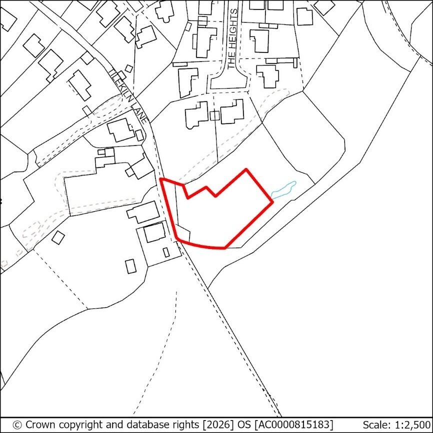
TP2: Land at Tilekiln Lane
Use: Permanent Site for Gypsies and Travellers
Minimum Indicative Capacity (pitches): 2
Sites Area: 0.17ha
Proposals for Development on this site should:
- Be informed by an Ecological Constraints and Opportunities Plan (ECOP) and Ecological Impact Assessment (EciA) and incorporate appropriate conservation and mitigation measures as recommended by the reports. The ECOP must make specific reference to the presence of the nearby Local Wildlife Site, Local Nature Reserve, Country Park, SSSI and High Weald National Landscape;
- Demonstrate a landscape-led approach to design and layout, which should follow the advice in the High Weald AONB Housing Design Guide where this would be relevant to this type of proposal;
- Safeguard the Dark Skies of the adjacent High Weald National Landscape in line with the Dark Skies Technical Advice Note and minimise light spill to areas of wildlife sensitivity such as those mentioned in (a) above;
- provide an Arboriculture Plan that demonstrates how existing trees and hedgerow on site will be integrated into the development, or how compensation will be made for their loss;
- Include a Historic Environment Record (HER) informed desk-based assessment of potential interests within an Archaeological Notification Area and agree to an appropriate programme of archaeological investigation secured by condition/s prior to any development works (as advised by local authority archaeologists).
- Other than where removal is essential for access, retain and enhance existing landscaping to maintain an amenity and pollution buffer with the surrounding area;
- Access to the site must meet highways standards and early engagement with the Highway Authority is advised;
- Provide a connection to the sewerage system at the nearest point of adequate capacity, as advised by Southern Water and ensure future access to the existing sewerage and water supply infrastructure for maintenance and upsizing purposes.
- Include an appropriate drainage plan to manage surface water and preserve water quality.
Part two – Employment Allocations Comment
6.165To meet the future additional provision for employment space in Hastings, the council is guided by the employment evidence studies listed below:
6.166- Housing and Economic Development Needs Assessment (HEDNA) 2024 and HEDNA Update 2026
- Strategic Housing and Employment Land Availability Assessment 2026
- East Sussex Economic Prosperity Strategy 2024
- Room to Grow 2
- East Sussex Employment Land Pipeline Study 2023
- Land and Premises Supply Study: Market Assessment for East Sussex 2020
- East Sussex Economic Recovery Plan 2020 (Updated February 2022)
6.167A policy approach is recommended by the NPPF and Planning Practice Guidance whereby Councils positively plan to enhance the local economy and encourage jobs growth through the allocation of sufficient land to meet existing and future needs.
6.168Where site allocations identified within this plan are at risk of flooding, the council will ensure that sites are sequentially tested in line with National Planning Policy and Practice Guidance, and that the exception test is applied where necessary. .
6.169The Local Plan evidence identifies a need for 19,830sqm business floorspace by 2041. Approximately 15,130sqm of floorspace will be delivered through employment allocations located within the Strategic Industrial Employment Areas (SIEAs). This be delivered on allocated sites within SIEA1 (Queensway Corridor) and SEIA2 (Ivyhouse Lane).
6.170These allocations are consistent with SIEAs being assessed as suitable locations to meet the majority of Hastings’ future employment needs. This is recognised in Policy SP3 which seeks to protect the integrity and function of SIEAs as key locations for future employment growth. Outside of SIEA1 and 2 there are no proposed site allocations within other SIEAs and it is anticipated that over the lifetime of the plan development in these locations will come forward as part of ongoing estate regeneration as older or lower quality stock is replaced by more modern employment floorspace that better reflects modern sectors and their processes and improves their layout and form to deliver a higher density within each SIEA as a whole.
6.171The majority of the allocated employment sites were previously identified as allocations in the Hastings Development Management Plan 2015. These sites have been reassessed in detail by the council and remain suitable, achievable and deliverable for business (office or industrial) use. With specific regard to deliverability, it is noted that the recent provision of strategic road infrastructure, which was not present upon adoption of the previous Local Plan, has materially increased the opportunity and attractiveness to the market of these sites.
6.172Local Industrial Employment Areas (LIEA) provide a unique local function that is often sector specific and will be supported and protected through policy to where proposals are submitted that will enhance their existing function. In addition to the allocated employment sites set out below, the Plan also provides support for the enhancement of existing Strategic and Local Industrial Employment Areas and other sites currently or last in employment, subject to the criteria set out in Policy SP3 and E1 being met. There is also potential for small pockets of employment land to be delivered on the mixed-use housing allocation sites provided this will not compromise residential amenity.
6.173With the potential that further land may come forward, potentially aligned with the Regeneration Area sites, flexibility in supply has been established. Consequently, the council will undertake robust monitoring of employment land supply and losses on an annual basis to ensure sufficient land is available to meet identified needs.
Marline Valley Woods SSSI and the Queensway Corridor
6.174All development in the SIEA1 Queensway Corridor has the potential to affect the SSSI. The Marline Valley Woods SSSI contains interest features which include a number of rare bryophytes within the SSSI’s steep-sided ghyll stream. The interest features of the SSSI rely on the continuation of the existing hydrological regime (the quality and quantity of water flowing from adjacent land to the SSSI). The SSSI is hydrologically linked to these locations.
6.175All applications in this location, whether in relation to sites allocated within this plan or as applications for sites yet to be identified, have the potential to affect the hydrogeology of the SSSI via impacts to the existing ground and surface water.
6.176Boreholes and trial pits in this area have shown it to be highly variable in nature with regard to the depth of the permeable layers and highly complex to develop. Applications must demonstrate that development will not impact the SSSI and that underlying sandstone layers will not be breached either by the finished development or during the construction phase.
Interpretation of Site Allocation Policies
6.177Site allocation policies should not be read in isolation. The Plan needs to be read as a whole in order to ascertain which policies will be relevant to individual sites or proposals. Local plans should not repeat National planning guidance or regulations or matters already addressed elsewhere within development plans. Therefore, where site allocation policies do not explicitly reference subject areas covered elsewhere within the development plan, it does not mean that these subject areas are not considered relevant. Where subject areas are specifically covered within site allocations it is because the are unique circumstances surrounding that site that should be taken into account when preparing planning applications in addition to the other policies of the plan.
Policy EA1: Applications for Employment Uses Comment
The Plan needs to be read as a whole in order to ascertain which policies will be relevant to individual sites or proposals. Proposals for new or enhanced employment uses should take account of the site selection criteria and design specifications set out in Policy SP3.
Proposals should, where appropriate, address the following material considerations within proposals for development. For specific requirements applicants should refer to the council’s validation checklist:
- Design and character
- Heritage impacts
- Residential amenity
- Transport, including sustainable and active travel
- Flood risk and sustainable drainage solutions (SuDS) for surface water management
- Contamination, nuisance and hazards including where the ‘agent of change’ principle applies
- Land stability
- Ecology and Green and Blue infrastructure
- Biodiversity Net Gain
- Arboriculture and landscape
- Waste and recycling
- Contributions and legal agreements
Where relevant, proposals should take account of underground water infrastructure, high pressure gas mains and overhead power transmission and distribution lines in the design of the layout of the site. Easements may be required, which will affect the site layout or require diversion, and these should be clear of all proposed buildings and tree planting.
The following sites are allocated, as shown on the Policies Map, for employment use to meet the employment land requirement set out in Policy SP1.
The sites listed in the table below (and as shown on the Policies Map) are allocated for employment use to deliver the employment floorspace requirement set out in Policy SP3.
Detailed requirements can be found in the Validation List.
Specific Locational Requirements: Marline Valley Woods SSSI
Proposals for commercial development adjacent to the Marline Valley Woods SSSI must be SuDS-led and maximise greenspace, avoid breaching the underlying sandstone layer and use borehole and/ or trial pit data to inform relevant groundwater assessments.
Approach to Industrial Employment Areas
Table 11: List of SIEA/ LIEA
|
Industrial Location |
Designation |
Policy approach |
|
Queensway North and South |
SIEA1 |
Safeguard, enhance and intensify. |
|
Ridge West |
SIEA1 |
Safeguard, enhance and intensify. |
|
Castleham |
SIEA1 |
Safeguard, enhance and intensify. |
|
Conqueror |
SIEA1 |
Safeguard, enhance and intensify. |
|
Churchfields |
SIEA1 |
Safeguard, enhance and intensify. |
|
Ivyhouse and Rock Lane (incorporating Hayward Way) |
SIEA2 |
Safeguard, enhance and intensify. |
|
Ponswood |
SIEA3 |
Safeguard, enhance and intensify. |
|
Bulverhythe East |
SIEA4 |
Safeguard, enhance and intensify. |
|
Bulverhythe West |
SIEA4 |
Safeguard, enhance and intensify. |
|
Roebuck Estate |
LIEA1 |
Safeguard and enhance. |
|
Fishmarket |
LIEA2 |
Safeguard and enhance. |
Figure 29: LIEA Locations
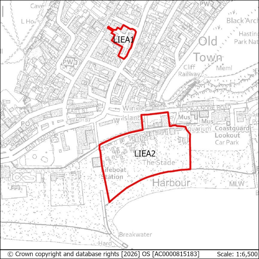
Approach to allocated sites
Extents of SIEA should be viewed using the Policies Map hastings.gov.uk/ localplanTable 12: Proposed allocations within SIEA1
|
Site Ref. |
Site Address |
Site Area (ha) |
Use |
Indicative Capacity (sqm floorspace) |
Proposals should comply with these additional site-specific requirements: |
|
SIEA1 – Queensway Corridor |
|||||
|
ES1 |
Queensway North, Queensway |
4.68 |
Industrial |
6,500 |
See site Policy ES1 |
|
ES2 |
Site PX, Churchfields Estate |
0.58 |
Industrial |
1,800 |
See site Policy ES2 |
|
ES3 |
NX2 Sidney Little Road, Churchfields Estate |
0.32 |
Industrial |
860 |
See site Policy ES3 |
|
ES4 |
NX3 Sidney Little Road, Churchfields Estate |
0.17 |
Industrial |
280 |
See site Policy ES4 |
|
ES8 |
Land at junction of The Ridge West and Queensway |
2.95 |
Industrial |
4,700 |
See site Policy ES8 |
|
ES10 |
Marline Fields, Enviro21 Business Park, Land West of Queensway |
1.38 |
Industrial |
550 |
See site Policy ES10 |
Table 13: Proposed allocations within SIEA2
|
SIEA2 – Ivyhouse Lane |
|||||
|
ES5 |
Adjacent Unit C, 1-8 Brook Way |
0.16 |
Industrial |
500 |
See site Policy ES5 |
|
ES6 |
UK Power Networks, Hastings Main, The Ridge/ Ivyhouse Lane |
1.57 |
Industrial |
1,900 |
See site Policy ES6 |
|
ES7 |
Ivyhouse Lane, Northern Extension |
2.13ha |
Industrial |
2,800 |
See site Policy ES7 |
Policy ES1: Queensway North, Queensway Comment
6.178The site occupies a prominent position in SIEA1 and is accessed from A2690 Queensway with strong links to both the A259 (Brighton-Ashford) and the A21 (London). The site is capable of delivering a range of layouts, including a single larger size unit or a broader mix of small-medium size units. The site also has strong potential to accommodate low carbon technologies as part of any development, including solar PV.
6.179The site is adjacent to a Site of Special Scientific Interest and Local Nature Reserve, with a Local Wildlife Site and Ancient Woodland within the site and nearby. Due to the site sitting within the Impact Risk Zone (IRZ) for the Marline Valley Woods SSSI, Natural England should be consulted at the earliest possible stage. The development of the site must be SuDS-led and maximise onsite greenspace, with proposals informed by an agreed programme of hydrological and groundwater monitoring for minimum 12 months to ensure that development will not negatively impact the local conditions necessary to support the species dependant on the Marline Valley Woods SSSI, either alone or cumulatively with existing or permissioned development.
6.180Due to the topography of the site, investigations of ground behaviour and land stability should take into account the hydrology and hydrogeology of the site, and a detailed stability report will be required. Proposals for SuDS that include attenuation may be appropriate subject to hydrological, hydrogeological and ground behaviour assessments
6.181The site itself is undulating with areas of dense scrub and mature trees. These designated areas and Ancient Woodland must be specifically referenced in any Ecological Constraints and Opportunities Plan (ECOP) and any proposal must also be informed by an Ecological Impact Assessment (EcIA). The site itself should be thoroughly surveyed to identify constraints. Any development proposal must seek to avoid or minimise impact on these areas during both the construction and occupation phases of the development, including the hydrological effects of drainage into the Marline Valley Stream. The introduction of pollutants to the highly vulnerable groundwater aquifer within the site should likewise be avoided during both phases and cumulative impacts of development within the IRZ should be considered. Development proposals should seek to avoid breaching the underlying sandstone layer.
6.182The site is within an ACIB with mapped measures for nature networks. The development would need to ensure that an ecological management plan is developed for the site
6.183It is anticipated that the site will feature an ecology buffer zone to the North West of the site closest to the SSSI, and an area of Ancient Woodland which will require a suitable buffer. Opportunities to deliver green and blue infrastructure and net gain activities in this location should be explored.
6.184A lighting plan will be required due to the close proximity to areas of wildlife sensitivity and must demonstrate how steps have been taken to reduce light spill that may impact on these areas. An arboriculture plan must also be provided to set out how existing trees will be either integrated into the proposal, or their loss will be compensated for. The site has a natural tree boundary that should be retained and enhanced where possible, particularly to the north of the site where it borders a holiday park to safeguard the amenity of occupiers. The ECOP, lighting plan and arboriculture plan can all form part of the same document if appropriate.
6.185The site falls within an Area of Opportunity (AoO) for waste management facilities. Generally, it is considered acceptable for employment land uses to co-exist with waste sites, depending on the type of employment use (e.g. B2 or B8) and the nature of the waste operation taking place. The agent of change principle would also apply, to ensure that any potential waste operation could successfully operate alongside other business or industrial uses within the site.
6.186Development proposals should be supported by transport evidence, taking a vision led and validate approach with particular consideration of the transport impact along The Ridge.
6.187It is anticipated that the site will be served by a single looped spine road accessed directly off Queensway - with a simple main ‘T’ junction and a secondary ‘emergency only’ junction. Limited improvements to Queensway itself may be required. Proposals should support access to and from the site by public and sustainable travel, including consideration of a pedestrian connection to the adjoining chalet site or the adjacent residential area. There may also be opportunities to improve connections to nearby Rights of Way.
6.188Improvements to better support access to the site through public and sustainable transport may be required. Further advice on transport matters is available from East Sussex County Council.
6.189Where possible, proposals should seek to make connections to the area of open space bordering High Beech Close to enhance the amenity value of the finished development and deliver policy compliant green infrastructure within the site.
Figure 30: Queensway North, Queensway
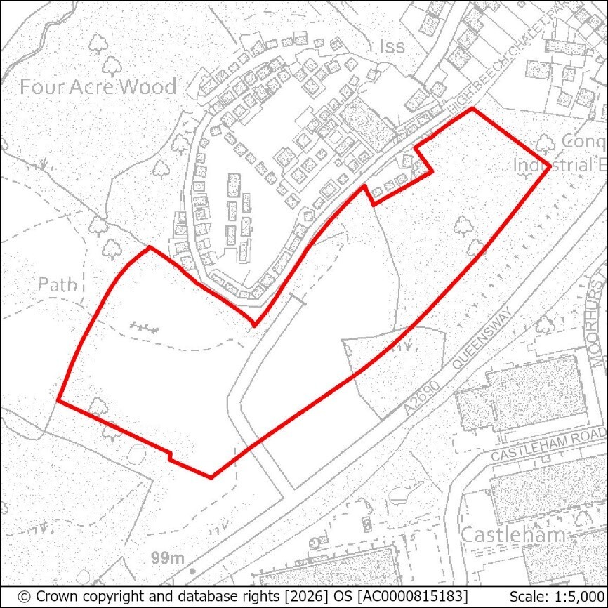
Policy ES1: Queensway North, Queensway
Use: Employment
Minimum Indicative Capacity (minimum floorspace): 6,500sqm
Site area: 4.70ha
Proposals for development on this site should:
- Demonstrate an approach that is SuDS-led to design and layout, taking into account the results of any hydrological and groundwater monitoring to ensure negative impacts on the Marline Valley Woods SSSI can be avoided;
- Be designed in a way that contributes positively to the intensification of SIEA1 while maximising onsite greenspace;
- Be supported by an Ecological Impact Assessment (EcIA) and include an Ecological Constraints and Opportunities Plan (ECOP) and incorporate appropriate conservation and mitigation measures as recommended by the EcIA. The ECOP must make specific reference to the presence of the adjacent Site of Special Scientific Interest (SSSI), the results of site surveys of ES1 itself, and to other nearby areas of wildlife sensitivity. Opportunities for enhancement should have regard to the LNRS and should include an ecological management plan;
- Include a lighting plan to minimise light spill to nearby areas of wildlife sensitivity, including nearby SSSI, Ancient Woodland and Local Wildlife Site;
- Include boundary landscaping to act as a buffer to the existing holiday park to the north;
- Provide an Arboriculture Plan that demonstrates how existing trees on site will be integrated into the development, including the existing tree belts running through the centre of the site, and at the western boundary;
- Ensure drainage schemes, including SuDS, are appropriate for the site and take into account the impact on the Marline Valley Stream, the SSSI and groundwater pollution vulnerability. Hydrological and hydrogeological monitoring using trial pits and/ or boreholes should inform the drainage plans for this site;
- Include traffic access improvements onto and off Queensway (and an additional emergency access);
- Include appropriate active and sustainable travel infrastructure;
- Be supported by a Transport Assessment and Travel Plan. The Transport Assessment must take account of the site's proximity to The Ridge. Proposals must also indicate how the conclusions and recommendations of the Assessment have been incorporated within the development and set out a monitor and manage regime to ensure the impact of development can be appropriately mitigated through further transport interventions.
- Investigate the impact of ground behaviour and land stability and incorporate remediation or mitigation measures as appropriate;
- Investigate the potential for contamination within or effecting the site, and incorporate remediation or mitigation measures as appropriate;
- Be designed to avoid or, where this is not possible, mitigate the impact of potential pollution and environmental hazards to occupiers, the environment, and neighbours;
- Investigate the potential to make navigable connections to the area of open space adjacent to the site;
- Provide policy compliant green and blue infrastructure within the site.
Policy ES2: Site PX, Churchfields Estate Comment
6.190The site sits within SIEA1, and is well connected A2690 Queensway with strong links to both the A259 (Brighton-Ashford) and the A21 (London). A modern, low-carbon business centre has been developed on site QX to the North of this location and the site offers potential for a similar style of development. The site also has strong potential to accommodate low carbon technologies as part of any development, including solar PV.
6.191The site is adjacent to an area of Ancient Woodland to the East, and a Local Wildlife Site sits nearby to the South East. The site itself is sloping with areas of dense scrub. The site will require an Ecological Constraints and Opportunities Plan (ECOP) and any proposal must also be informed by an Ecological Impact Assessment (EcIA). The Ancient Woodland must be specifically referenced in any Ecological Constraints and Opportunities Plan (ECOP), and the site itself should be thoroughly surveyed to identify constraints. Due to the site sitting within the Impact Risk Zone (IRZ) for the Marline Valley Woods SSSI and Combe Haven SSSI, Natural England should be consulted at the earliest possible stage. The site is within an ACIB with mapped measures for woodland and nature networks. The development would need to ensure that an ecological management plan is developed for the site.
6.192Any development proposal must seek to avoid or minimise impact on these areas during both the construction and occupation phases of the development. The introduction of pollutants to the highly vulnerable groundwater aquifer within the site should likewise be avoided during both phases. Combining or complimenting ecological and SuDS measures with those already implemented through the development of site QX may be appropriate.
6.193The site slopes away steeply to the South and occupies a relatively high position within the valley. A fault line runs close to the Southeast corner of the site, with a watercourse close by. Due to these characteristics and the base geology, investigations of ground behaviour and land stability should take into account the hydrology and hydrogeology of the site, the strata and the potential for subterranean water conduits. A detailed stability report will be required and should inform any potential SuDS design for the site.
6.194A lighting plan will be required due to the close proximity to areas of wildlife sensitivity and must demonstrate how steps have been taken to reduce light spill that may impact on these areas. An arboriculture plan must also be provided to set out how existing trees will be either integrated into the proposal, or their loss will be compensated for. The site has a natural tree boundary to the south and east that should be retained and enhanced where possible. The ECOP, lighting plan and arboriculture plan can all form part of the same document if appropriate.
6.195A Transport Assessment and Travel Plan will be required setting out a vision led and validate approach, prioritising public and sustainable travel. There are a number of potential site access routes, including opportunity to connect to an existing access route at site QX. The choice of access point should be justified and development proposals will need to show consideration of the transport impact along The Ridge.
Figure 31: Site PX, Churchfields Estate
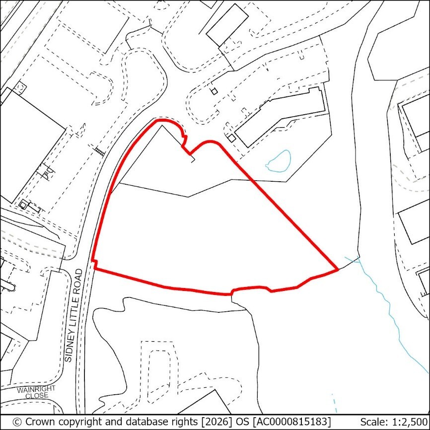
Policy ES2: Site PX, Churchfields Estate
Use: Employment
Minimum Indicative Capacity (minimum floorspace): 1,800sqm
Site area: 0.58ha
Proposals for development on this site should:
- Be designed in a way that contributes positively to the intensification of SIEA1;
- Be supported by an Ecological Impact Assessment (EcIA) and include an Ecological Constraints and Opportunities Plan (ECOP) and incorporate appropriate conservation and mitigation measures as recommended by the EcIA. The ECOP must make specific reference to the presence of the adjacent Ancient Woodland, Priority Habitat and the results of site surveys of ES2 itself, and to other nearby areas of wildlife sensitivity including identifying appropriate buffers. Opportunities for enhancement should have regard to the LNRS and should include an ecological management plan;
- Include a lighting plan to minimise light spill to nearby areas of wildlife sensitivity, including adjacent Ancient Woodland and nearby Local Wildlife Site;
- Include boundary landscaping appropriate to the setting and taking into account existing trees and vegetation;
- Provide an Arboriculture Plan that demonstrates how existing trees on site will be integrated into the development, including the existing tree belts running through the centre of the site, and at the southern and eastern boundary;
- Ensure drainage schemes, including SuDS, are appropriate for the site and take into account Impact Risk Zones, the strata, potential for subterranean water conduits and groundwater pollution vulnerability. Hydrological and hydrogeological monitoring should inform the drainage plans for this site;
- Include appropriate active and sustainable travel infrastructure, maximising walking, wheeling and cycling links, as well as appropriate access to public transport.
- Be supported by a Transport Assessment and Travel Plan. The Transport Assessment must take account of the site's proximity to The Ridge and set out clear justification for any proposed access to the site, which must be agreed with the Highway Authority. Proposals must also indicate how the conclusions and recommendations of the Assessment have been incorporated within the development and include arrangements to implement a monitor and manage approach to identify whether further transport interventions are required.
- Investigate the impact of ground behaviour and land stability and incorporate remediation or mitigation measures as appropriate;
- Investigate the potential for contamination within or effecting the site, and incorporate remediation or mitigation measures as appropriate;
- Be designed to avoid or, where this is not possible, mitigate the impact of potential pollution and environmental hazards to the environment, occupiers and neighbours;
- Provide policy compliant green and blue infrastructure within the site;
Policy ES3: NX2, Sidney Little Road, Churchfields Estate Comment
6.196The site occupies a prominent position in SIEA1, and is well linked to the A2690 Queensway with strong links to both the A259 (Brighton-Ashford) and the A21 (London). It is one of a group of three small development plots. The first, NX1 immediately to the south, was developed as a row of small business units. The site is capable of delivering additional small units. The site also has strong potential to accommodate low carbon technologies as part of any development, including solar PV.
6.197The site is adjacent to an area of Ancient Woodland to the East, and a Local Wildlife Site sits nearby to the South East. The site itself is sloping with areas of dense scrub. The site will require an Ecological Constraints and Opportunities Plan (ECOP) and any proposal must also be informed by an Ecological Impact Assessment (EcIA). The Ancient Woodland must be specifically referenced in any Ecological Constraints and Opportunities Plan (ECOP), and the site itself should be thoroughly surveyed to identify constraints. Any development proposal must seek to avoid or minimise impact on these areas during both the construction and occupation phases of the development. The introduction of pollutants to the highly vulnerable groundwater aquifer within the site should likewise be avoided during both phases. The site is within an ACIB with mapped measures for woodland and nature networks. The development would need to ensure that an ecological management plan is developed for the site.
6.198There is potential to create integrated ecological and surface water management interventions, including SuDS, with sites PX and NX3, building upon those already delivered through the development of site QX. Due to the site sitting within the Impact Risk Zone (IRZ) for the Marline Valley Woods SSSI and Combe Haven SSSI, Natural England should be consulted at the earliest possible stage.
6.199A lighting plan will be required due to the close proximity to areas of wildlife sensitivity and must demonstrate how steps have been taken to reduce light spill that may impact on these areas. An arboriculture plan must also be provided to set out how existing trees will be either integrated into the proposal, or their loss will be compensated for. The site has a natural tree boundary to the south and east that should be retained and enhanced where possible. The ECOP, lighting plan and arboriculture plan can all form part of the same document if appropriate.
6.200The site slopes to the South and includes some areas of undulation. A fault line runs through the Southwest portion of the site. The area of high groundwater vulnerability to pollution sits to the South of the fault. Due to these characteristics, investigations of ground behaviour and land stability should take into account the hydrology and hydrogeology of the site, the strata and the potential for subterranean water conduits. A detailed stability report will be required and should inform any potential SuDS design for the site.
6.201A Transport Assessment and Travel Plan will be required, setting out a vision led and validate approach to development. The existing access off Sidney Little Road is configured to serve both the existing units and those still to be built on this site and on site NX3, however improvements to better support access to the site through public and sustainable transport may be required. Development proposals will need to show consideration of the transport impact along The Ridge.
Figure 32: NX2, Sidney Little Road, Churchfields Estate
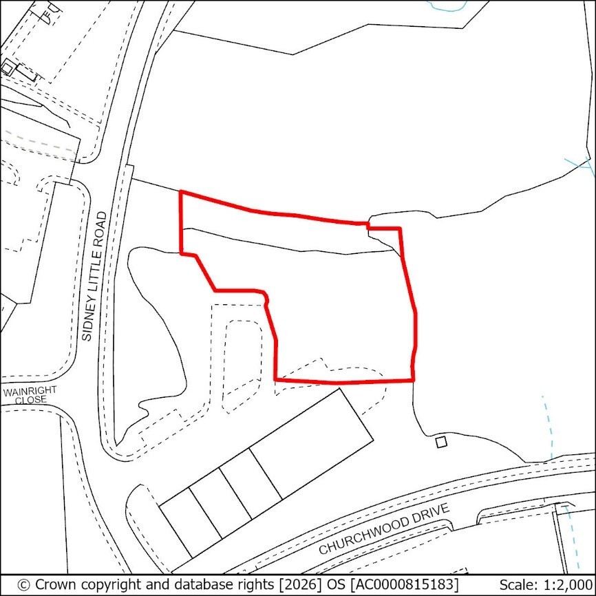
Policy ES3: NX2, Sidney Little Road, Churchfields Estate
Use: Employment
Minimum Indicative Capacity (minimum floorspace): 800sqm
Site area: 0.32ha
Proposals for development on this site should:
- Be designed in a way that contributes positively to the intensification of SIEA1;
- Be supported by an Ecological Impact Assessment (EcIA) and include an Ecological Constraints and Opportunities Plan (ECOP) and incorporate appropriate conservation and mitigation measures as recommended by the EcIA. The ECOP must make specific reference to the presence of the adjacent Ancient Woodland, the results of site surveys of ES3 itself, and to other nearby areas of wildlife sensitivity. Opportunities for enhancement should have regard to the LNRS and should include an ecological management plan;
- Include a lighting plan to minimise light spill to nearby areas of wildlife sensitivity, including adjacent Ancient Woodland and nearby Local Wildlife Site;
- Include boundary landscaping appropriate to the setting and taking into account existing trees and vegetation;
- Provide an Arboriculture Plan that demonstrates how existing trees on site and at the southern and eastern boundary will be integrated into the development;
- Ensure drainage schemes, including SuDS, are appropriate for the site and take into account Impact Risk Zones, the strata, potential for subterranean water conduits and groundwater pollution vulnerability. Hydrological and hydrogeological monitoring should inform the drainage plans for this site;
- Include appropriate active and sustainable travel infrastructure, maximising walking, wheeling and cycling links, as well as appropriate access to public transport;
- Be supported by a Transport Assessment and Travel Plan. The Transport Assessment must take account of the site's proximity to The Ridge. Proposals must also indicate how the conclusions and recommendations of the Assessment have been incorporated within the development, and include arrangements to implement a monitor and manage approach to determine whether additional transport interventions are required;
- Investigate the impact of ground behaviour and land stability incorporating remediation or mitigation measures as appropriate;
- Investigate the potential for contamination within or effecting the site, and incorporate remediation or mitigation measures as appropriate;
- Be designed to avoid or, where this is not possible, mitigate the impact of potential pollution and environmental hazards to the environment, occupiers and neighbours;
- Provide policy compliant green and blue infrastructure within the site.
Policy ES4: NX3, Sidney Little Road, Churchfields Estate Comment
6.202The site occupies a prominent position in SIEA1, and is well linked to the A2690 Queensway with strong links to both the A259 (Brighton-Ashford) and the A21 (London). It is one of a group of three small development plots. The first, NX1 immediately to the south, was developed as a row of small business units. This site is capable of delivering additional small units. The site also has strong potential to accommodate low carbon technologies as part of any development, including solar PV.
6.203The site is in close proximity to an area of Ancient Woodland to the East, and Local Wildlife Sites to the South East and South West. The site itself is sloping with areas of dense scrub. These areas of wildlife sensitivity and the site itself should be thoroughly surveyed as part of the Ecological Constraints and Opportunities Plan (ECOP), to identify constraints. Any development proposal must seek to avoid or minimise impact on these areas during both the construction and occupation phases of the development. The introduction of pollutants to the highly vulnerable groundwater aquifer to the South of the site should likewise be avoided during both phases.
6.204There is potential to create integrated ecological and surface water management interventions, including SuDS, with sites PX and NX2, building upon those already delivered through the development of site QX. Due to the site sitting within the Impact Risk Zone (IRZ) for the Marline Valley Woods SSSI and Combe Haven SSSI, Natural England should be consulted at the earliest possible stage.
6.205A lighting plan will be required due to the close proximity to areas of wildlife sensitivity and must demonstrate how steps have been taken to reduce light spill that may impact on these areas. An arboriculture plan must also be provided to set out how existing trees will be either integrated into the proposal, or their loss will be compensated for. The site has a natural tree boundary to the West that should be retained and enhanced where possible. The ECOP, lighting plan and arboriculture plan can all form part of the same document if appropriate.
6.206The site slopes to the South and undulates throughout. A fault line runs through the Southwest portion of the site. Due to these characteristics, investigations of ground behaviour and land stability should take into account the hydrology of the site, the strata and the potential for subterranean water conduits. A detailed stability report will be required and should inform any potential SuDS design for the site.
6.207A Transport Assessment and Travel Plan will be required, setting out a vision led and validate approach to development. The existing access off Sidney Little Road is configured to serve both the existing units and those still to be built on this site and on site NX2, however improvements to better support access to the site through public and sustainable transport may be required. Development proposals will need to show consideration of the transport impact along The Ridge.
Figure 33: NX3, Sidney Little Road, Churchfields Estate
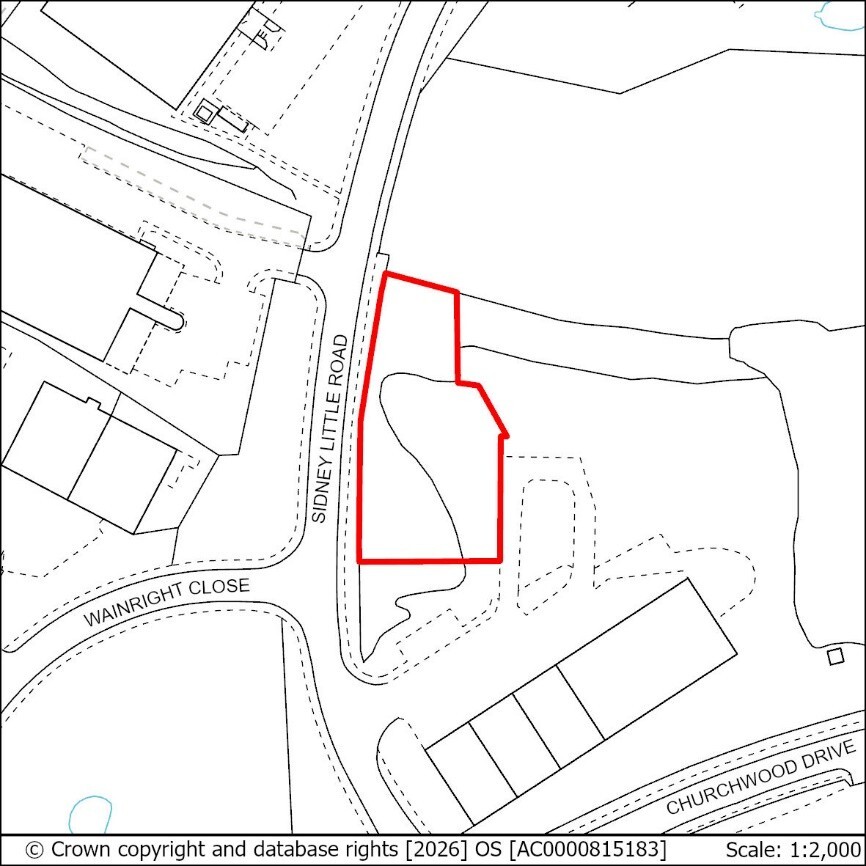
Policy ES4: NX3, Sidney Little Road, Churchfields Estate
Use: Employment
Minimum Indicative Capacity (minimum floorspace): 280sqm
Site area: 0.17ha
Proposals for development on this site should:
- Be designed in a way that contributes positively to the intensification of SIEA1;
- Be supported by an Ecological Impact Assessment (EcIA) and include an Ecological Constraints and Opportunities Plan (ECOP) and incorporate appropriate conservation and mitigation measures as recommended by the EcIA. The ECOP must make specific reference to the presence of the adjacent Ancient Woodland, the results of site surveys of ES4 itself, and to other nearby areas of wildlife sensitivity.
- Include a lighting plan to minimise light spill to nearby areas of wildlife sensitivity, including nearby Ancient Woodland and Local Wildlife Site;
- Include boundary landscaping appropriate to the setting and taking into account existing trees and vegetation;
- Provide an Arboriculture Plan that demonstrates how existing trees on site and at the western boundary will be integrated into the development;
- Ensure drainage schemes, including SuDS, are appropriate for the site and take into account Impact Risk Zones, the strata, potential for subterranean water conduits and groundwater pollution vulnerability. Hydrological and hydrogeological monitoring should inform the drainage plans for this site;
- Include appropriate active and sustainable travel infrastructure, maximising walking, wheeling and cycling links, as well as appropriate access to public transport;
- Be supported by a Transport Assessment and Travel Plan. The Transport Assessment must take account of the site's proximity to The Ridge. Proposals must also indicate how the conclusions and recommendations of the Assessment have been incorporated within the development, and include arrangements to implement a monitor and manage approach to determine whether further transport interventions are required;
- Investigate the impact of ground behaviour and land stability incorporating remediation or mitigation measures as appropriate;
- Investigate the potential for contamination within or effecting the site, and incorporate remediation or mitigation measures as appropriate;
- Be designed to avoid or, where this is not possible, mitigate the impact of potential pollution and environmental hazards to the environment, occupiers and neighbours;
- Provide policy compliant green and blue infrastructure within the site;
Policy ES5: Adjacent Unit C, 1-8 Brook Way Comment
6.208The site occupies a prominent position in SIEA2, and is well linked to the B2093 The Ridge with strong links to both the A259 (Brighton-Ashford) and the A21 (London). It is a relatively small plot in a small depression within a larger sloping system. It is in close proximity to a number of taller units, with the topography of the land rising towards The Ridge to the South. The site is capable of delivering additional units that are sensitive to the setting of the Rock Lane – Ivyhouse Lane area and the adjacent National Landscape as a whole. The site also has strong potential to accommodate low carbon technologies as part of any development, including solar PV.
6.209The site is adjacent to the National Landscape, including the Cemetery and Crematorium which has wide reaching views across the NL. Regard should be had to the High Weald National Landscape Area of Outstanding Natural Beauty (AONB) Unit Management Plan and associated Technical Guidance. Although the site has been allocated to meet strategic employment needs, any development must take full account of the effect on its setting, and views of it from other parts of the National Landscape – in particular from the Rock Lane and Hastings Cemetery areas from where it is visible. A landscape impact assessment should inform the design of any scheme.
6.210Due to the site sitting within the Impact Risk Zones (IRZ) for Maplehurst Wood SSSI and Hastings Cliffs to Pett Beach SSSI, Natural England should be consulted at the earliest possible stage. Any development proposal must seek to avoid or minimise negative impact on designated areas of landscape or environmental importance during both the construction and occupation phases of the development.
6.211A lighting plan will be required due to the close proximity to the National Landscape and must demonstrate how steps have been taken to reduce light spill that may impact on this area. Additional guidance on lighting plans in this location is provided in the High Weald Unit’s Dark Skies Technical Advice Note.
6.212Southern Water infrastructure crosses this site, this should be taken into account in the design of any proposal. Care should be taken to prevent the introduction of pollutants to the surface water sewer either during or following construction, in line with Policy SC18 (Pollution and Hazards).
6.213Due to the topographical position of the site, investigations of ground behaviour and land stability should take into account the hydrology of the site, and a detailed stability report will be required.
6.214Development proposals should be supported by a Transport Assessment and Travel Plan, taking a vision led and validate approach with particular consideration of the transport impact along The Ridge;
6.215Proposals should seek to enhance pedestrian and cycling infrastructure both to local residential areas and to existing links within the National Landscape that may support better connectivity to Rock Lane. This could potentially be delivered in combination with site ES7.
Figure 34: Adjacent Unit C, 1-8 Brook Way
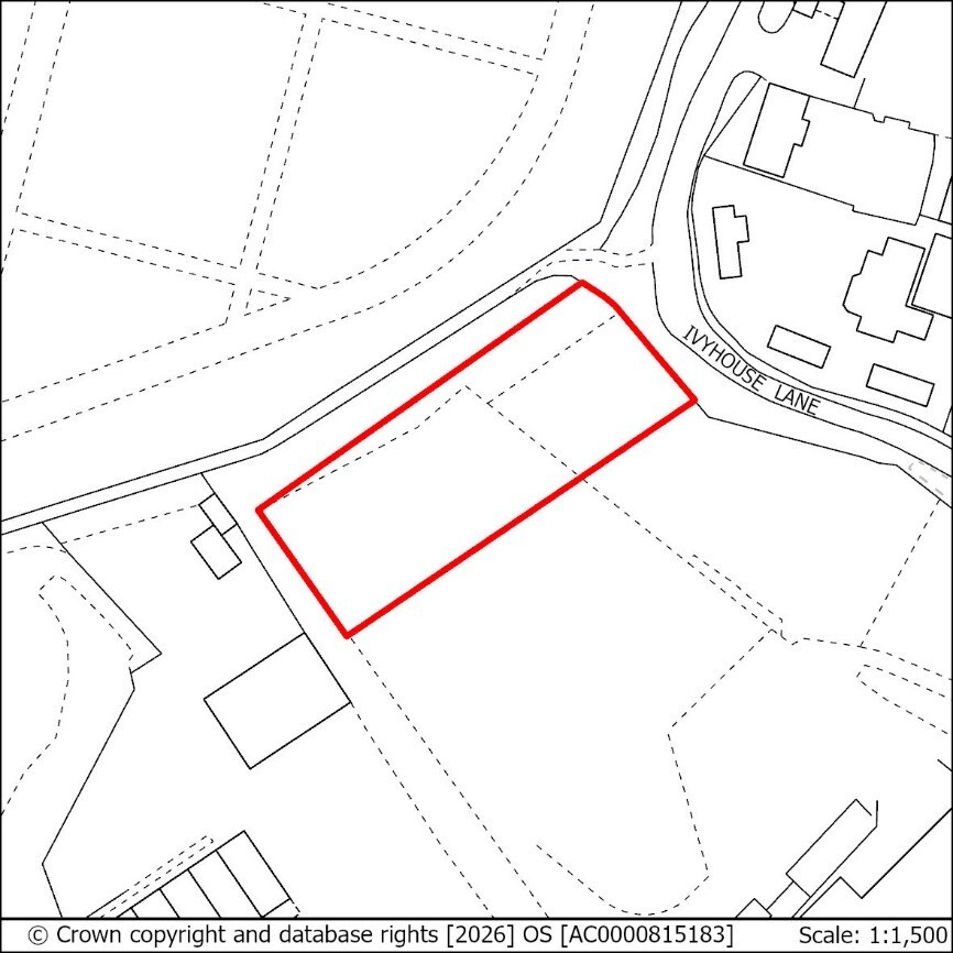
Policy ES5: Adjacent Unit C, 1-8 Brook Way
Use: Employment
Minimum Indicative Capacity (minimum floorspace): 500sqm
Site area: 0.16ha
Proposals for development on this site should:
- be designed in a way that contributes positively to the intensification of SIEA2;
- include landscape impact assessment, taking into account both its setting and long-range views across the National Landscape;
- include a lighting plan to minimise light spill to the nearby National Landscape;
- include boundary landscaping appropriate to the setting and taking into account existing trees and vegetation;
- ensure drainage schemes, including SuDS, are appropriate for the site and take into account the existing surface water sewer, the Impact Risk Zones and ground behaviour. Hydrological monitoring should inform the drainage plans for this site;
- Take into account the Southern Water infrastructure crossing the site;
- include appropriate active and sustainable travel infrastructure, including improvement to existing pedestrian and cycling routes, including links and enhancements to access PROW HAS/234/1;
- be supported by a Transport Assessment and Travel Plan, following a vision led and validate approach. The Transport Assessment must take account of the site's proximity to The Ridge. Proposals must also indicate how the conclusions and recommendations of the Assessment have been incorporated within the development proposal and include arrangements to implement a monitor and manage approach to mitigation;
- Access must be achieved from Brook Way.
- investigate the impact of ground behaviour and land stability and incorporate remediation or mitigation measures as appropriate;
- investigate the potential for contamination within or effecting the site, and incorporate remediation or mitigation measures as appropriate;
- be designed to avoid or, where this is not possible, mitigate the impact of potential pollution and environmental hazards to the environment, occupiers and neighbours;
- provide policy compliant green and blue infrastructure within the site
Policy ES6: UK Power Networks, Hastings Main, The Ridge/ Ivyhouse Lane Comment
6.216The site occupies a prominent position in SIEA2, and is well linked to the B2093 The Ridge with strong links to both the A259 (Brighton-Ashford) and the A21 (London). The site is contained within the Hastings main grid site and is not publicly accessible, with access to the site restricted to field staff due to the danger misuse of the site presents. It is expected to deliver updated operational space for the District Network Operator (DNO), including ancillary office functions.
6.217The site slopes to the North, with TPO trees along the Northern boundary. The site incorporates electricity infrastructure within the curtilage. Care should be taken to minimise risks associated with proximity to this infrastructure as much as possible, including ensuring appropriate overhead clearances for transmission and distribution lines are observed in line with GS6 and Policy SC18 (Pollution and Hazards). Due to the danger to local wildlife presented by the transmission lines, any ecological assessment will need to consider whether good quality onsite ecological enhancements can be delivered through an ecology report. In consideration of the constraints presented by this particular site, faunal enhancements such as bird and bat boxes will not be encouraged. However, ground based measures such as logpiles, hibernacula and hedgehog boxes will be welcomed.
6.218The site also has potential to accommodate low carbon technologies as part of any development, including heat pump technology where appropriate.
6.219The site is close to the National Landscape. Any development proposal must seek to avoid or minimise impact on these areas during both the construction and occupation phases of the development. There is already well-established boundary landscaping to the North and South sides of the site, which should be retained where possible. To the South side of the site, boundary landscaping should create an amenity buffer between the site and residential premises to the south side of B2093 The Ridge. A landscape impact assessment should inform the design of any scheme.
6.220The site sits within the Impact Risk Zone (IRZ) for Hastings Cliffs to Pett Beach SSSI, and Natural England should be consulted at the earliest possible stage. Any development proposal must seek to avoid or minimise negative impact on designated areas of landscape or environmental importance during both the construction and occupation phases of the development.
6.221A lighting plan will be required and must demonstrate how steps have been taken to reduce light spill from the site, including impacts on nearby residential premises to the south side of B2093 The Ridge.
6.222A small part of the Southwestern part of the site has high vulnerability to groundwater pollution. The introduction of pollutants to this aquifer or nearby surface water systems should be avoided during both construction and occupation phases.
6.223The site already benefits from direct access to the B2093 The Ridge, although there is also potential for a new or additional access to be created from Ivyhouse Lane. Due to the nature of the site, it is anticipated that the main mode of transport used to access it will be motorised fleet vehicles as opposed to more active forms of travel due to the primary purpose being the base facility for operational staff for delivering activity related to large scale electricity infrastructure maintenance and connection. Proposals should seek to provide EV charging infrastructure and work towards decarbonising the fleet where possible. Development proposals will need to show consideration of the transport impact along The Ridge, and a Transport Assessment and Travel Plan will be required.
Figure 35: UK Power Networks, Hastings Main, The Ridge/ Ivyhouse Lane
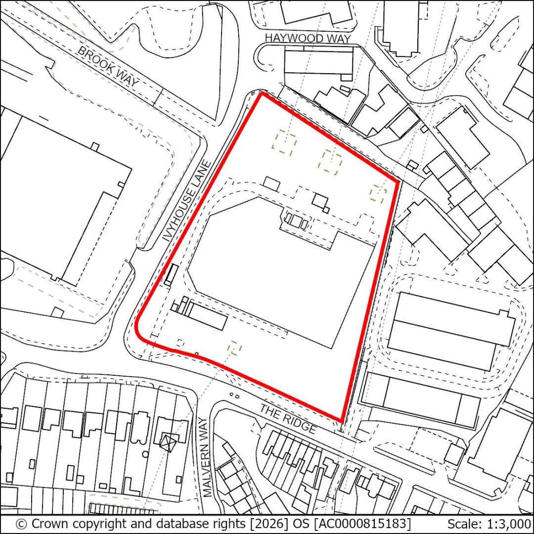
Policy ES6: UK Power Networks, Hastings Main, The Ridge/ Ivyhouse Lane
Use: Employment
Minimum Indicative Capacity (minimum floorspace): 1,900sqm
Site area: 1.57ha
Proposals for development on this site should:
- be designed in a way that contributes positively to the intensification of SIEA2;
- include landscape impact assessment, taking into account both its setting and long-range views across the National Landscape;
- Be supported by an Ecological Impact Assessment (EcIA) and include an Ecological Constraints and Opportunities Plan (ECOP) and incorporate appropriate conservation and mitigation measures as recommended by the EcIA. The ECOP should take into account site specific constraints;
- include a lighting plan to minimise light spill;
- retain and enhance boundary landscaping appropriate to the setting to the north and south of the site, taking into account existing trees and vegetation and continuing to safeguard the amenity of residential premises opposite the site to the south;
- ensure drainage schemes, including SuDS, are appropriate for the site and take into account the Impact Risk Zone and ground behaviour. Hydrological monitoring should inform the drainage plans for this site;
- be supported by a Transport Assessment and Travel Plan following a vision led and validate approach. The Transport Assessment must take account of the site's proximity to The Ridge. Proposals must also indicate how the conclusions and recommendations of the Assessment have been incorporated within the development proposal and include arrangements to implement a monitor and manage approach to mitigation;
- explore opportunities to relocate the main vehicle access for the site to Ivyhouse Lane;
- investigate the impact of ground behaviour and land stability and incorporate remediation or mitigation measures as appropriate;
- investigate the potential for contamination within or effecting the site, and incorporate remediation or mitigation measures as appropriate;
- be designed to avoid or, where this is not possible, mitigate the impact of potential pollution and environmental hazards to the environment, occupiers and neighbours;
- take into account the presence of overhead power transmission and distribution lines within the site and ensure that any scheme maintains easements and safe clearance distances during both the construction and occupation phases;
- provide policy compliant green and blue infrastructure within the site;
Policy ES7: Ivyhouse Lane, Northern Extension Comment
6.224The site occupies a prominent position in SIEA2, and is well linked to the B2093 The Ridge with strong links to both the A259 (Brighton-Ashford) and the A21 (London). It is an undeveloped site in close proximity to ES5 and slopes towards the South, with some undulation. A second slope system lies to the East, with evidence of overland flows connecting to a series of watercourses leading to culverts and sinks close to the railway line where it emerges from the Ore Tunnel. A fault line crosses the Northeast corner of the site. The site forms a natural extension to the Ivyhouse Lane estate and is capable of delivering additional units that are sensitive to the setting of the Rock Lane – Ivyhouse Lane area and the adjacent National Landscape as a whole. The site also has strong potential to accommodate low carbon technologies as part of any development, including solar PV.
6.225The site is within the National Landscape. Regard should be had to the High Weald National Landscape Area of Outstanding Natural Beauty (AONB) Unit Management Plan and associated Technical Guidance. Although the site has been allocated to meet strategic employment needs, any development must take full account of the effect on its setting, and views of it from other parts of the National Landscape – in particular from the Rock Lane and Hastings Cemetery areas from which it is visible, and from the Caravan Park to the West. A landscape impact assessment should inform the design of any scheme.
6.226The National Landscape must be specifically referenced in any Ecological Constraints and Opportunities Plan (ECOP), and the site itself should be thoroughly surveyed to identify constraints and opportunities for delivering biodiversity net gain. Due to the site sitting within the Impact Risk Zone (IRZ) for Hastings Cliffs to Pett Beach SSSI, Natural England should be consulted at the earliest possible stage. Any development proposal must seek to avoid or minimise negative impact on designated areas of landscape or environmental importance during both the construction and occupation phases of the development.
6.227A lighting plan will be required due to the position of the site within the National Landscape and must demonstrate how steps have been taken to reduce light spill that may impact on this area. Additional guidance on lighting plans in this location is provided in the High Weald Unit’s Dark Skies Technical Advice Note.
6.228The site contains a well-defined tree boundary, as well as trees throughout the site. An arboriculture plan must also be provided to set out how existing trees will be either integrated into the proposal, or their loss will be compensated for. The site has a natural tree boundary that should be retained and enhanced where possible, particularly to the Northwest of the site where it borders a holiday park to safeguard the amenity of occupiers. The ECOP, lighting plan and arboriculture plan can form part of the same document if appropriate.
6.229A historic lane runs north-south within the site a provides some separation. Any proposal should ensure that it is sensitive to the setting of the lane itself and seek to incorporate it into the scheme.
6.230To the East of the track, there is an area with high vulnerability to groundwater pollution. The introduction of pollutants to this aquifer or nearby surface water systems or bodies should be avoided during both construction and occupation phases.
6.231Due to the size of the site, a Flood Risk Assessment will be required, which should incorporate recommendations for appropriate SuDS and measures to control surface water. Due to the topography, base geology and water interactions within the site, investigations of ground behaviour and land stability should take into account the hydrology and hydrogeology of the site, and a detailed land stability and drainage report will be required. Given the interactions between existing site hydrological features and the railway line, the potential for impact on the railway infrastructure nearby should be considered as part of this report and National Rail Route Asset Managers for Earthworks and Drainage should be consulted at an early stage.
6.232Transmission lines run to the East of the site, and care should be taken to ensure development of the site does not result in a loss of easements to maintain this infrastructure.
6.233The site falls within an Area of Search (AoS) for waste management facilities Generally, it is considered acceptable for employment land uses to co-exist with waste sites. This is depending on the type of employment use (B2 or B8) and the nature of the waste operation taking place. The agent of change principle would also apply, to ensure that any potential waste operation could successfully operate alongside other business or industrial uses within the site.
6.234Development proposals will need to show consideration of the transport impact along The Ridge, and a Transport Assessment and Travel Plan will be required which set out a vision led and validate approach to transport impacts from the site. Proposals should seek to enhance pedestrian and cycling infrastructure both to local residential areas and to existing links within the National Landscape that may support better connectivity to Rock Lane. This could potentially be delivered in combination with site ES5.
6.235Due to the proximity to the Borough boundary with neighbouring Rother District, relevant policies within their development plan documents will also apply. Assessments of environmental risk including flood risk, pollution and ground behaviour should consider the impacts from or on nearby areas in Rother District where this is relevant.
Figure 36: Ivyhouse Lane, Northern Extension
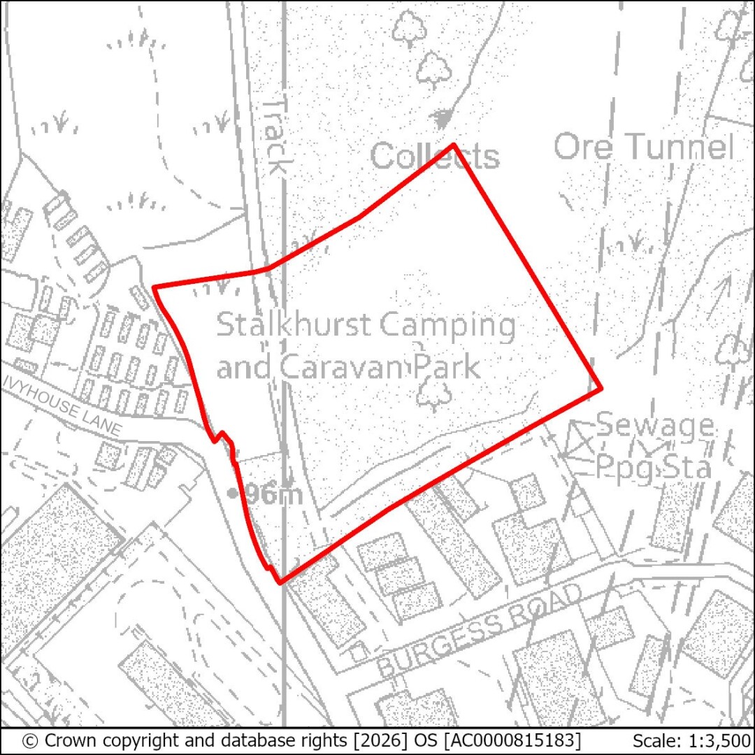
Policy ES7: Ivyhouse Lane, Northern Extension
Use: Employment
Minimum Indicative Capacity (minimum floorspace): 2,800sqm
Site area: 2.13ha
Proposals for development on this site should:
- Demonstrate a landscape-led approach to design and layout, which should follow the advice in the High Weald AONB Housing Design Guide;
- be designed in a way that contributes positively to the intensification of SIEA2;
- Be supported by an Ecological Impact Assessment (EcIA) and include an Ecological Constraints and Opportunities Plan (ECOP) and incorporate appropriate conservation and mitigation measures as recommended by the EcIA. The ECOP must make specific reference to the presence of the High Weald National Landscape, Impact Risk Zone, and adjacent Ancient Woodland, and include the results of site surveys of ES7 itself;
- Retain the historic sunken lane as a wildlife corridor;
- include a landscape impact assessment, taking into account both its setting and long-range views across the National Landscape;
- provide an Arboriculture Plan that demonstrates how existing trees on site will be integrated into the development or their loss compensated for;
- include a lighting plan to minimise light spill within the National Landscape;
- include boundary landscaping appropriate to the setting and taking into account existing trees and vegetation, including to the north east to act as a buffer to the existing holiday park;
- ensure drainage schemes, including SuDS, are appropriate for the site and take into account the existing surface water sewer, the Impact Risk Zones, the potential for impact on railway assets, and ground behaviour. Hydrological and hydrogeological monitoring should inform the drainage plans for this site;
- preserve existing Rights of Way within the site;
- include appropriate active and sustainable travel infrastructure, including improvement to existing pedestrian and cycling routes and maximising walking, wheeling and cycling links, as well as appropriate access to public transport;
- be supported by a Transport Assessment and Travel Plan, following a vision led and validate approach. The Transport Assessment must take account of the site’s proximity to The Ridge. Proposals must also indicate how the conclusions and recommendations of the Assessment have been incorporated within the development proposal and include arrangements to implement a monitor and manage approach to mitigation;
- investigate the impact of ground behaviour and land stability and incorporate remediation or mitigation measures as appropriate;
- investigate the potential for contamination within or effecting the site, and incorporate remediation or mitigation measures as appropriate;
- be designed to avoid or, where this is not possible, mitigate the impact of potential pollution and environmental hazards to the environment, occupiers and neighbours;
- ensure easements to transmission lines to the east of the site are maintained during all phases of development;
- Provide a connection to the sewerage system at the nearest point of adequate capacity, as advised by Southern Water and ensure future access to the existing sewerage and water supply infrastructure for maintenance and upsizing purposes. Ensure that any necessary reinforcement of the water and/or wastewater network is in place to accommodate the quantum and type of proposed development prior to connection, and that such reinforcement is agreed with Southern Water. This will be secured by condition. Early engagement with Southern Water is also recommended.
- Take account of Southern Water's underground infrastructure in the design of the layout of the site. Easements would be required, which may affect the site layout or require diversion, and these should be clear of all proposed buildings and tree planting.
- provide policy compliant green and blue infrastructure within the site.
Policy ES8: Land at the junction of The Ridge West and Queensway Comment
6.236The site occupies a prominent position in SIEA1, and is accessed from A2690 Queensway with strong links to both the A259 (Brighton-Ashford) and the A21 (London). The site is capable of delivering a range of layouts. The site has potential to deliver a small business park. It is anticipated that the development of the site will be phased, and proposals should clearly set out the sequence of any phasing in order that planning obligations can be attached to suitable milestones. The site also has strong potential to accommodate low carbon technologies as part of any development, including solar PV.
6.237The site is sloping, with a steep and heavily vegetated embankment to the West and Northwest of the site adjacent A2690 Queensway. Another area of embankment is located to the South where the site borders Whitworth Road. This results overall in a basin-like topography, with areas of undulation. There is the potential for artificial (or ‘made’) ground to be present within the site. A watercourse crosses the Southeast corner of the site and travels through a culvert below Whitworth Road, with a depression surrounding the culvert entrance. A fault line is also present in the far Southeast of the site. There is a Public Right of Way along the Eastern boundary of the site, entering the site close to the Southeast corner. The track continues across Whitworth Road through public open space and terminates at Beauport Home Farm Close.
6.238It is mainly open grassland and is surrounded by woodland with some belts of trees, including TPO trees in the Southwest and Northeast corners of the site. It is positioned close to the High Weald National Landscape and is adjacent to a Local Wildlife Site. These designated areas must be specifically referenced in any Ecological Constraints and Opportunities Plan (ECOP), and the site itself should be thoroughly surveyed to identify constraints.
6.239Due to the site sitting within the Impact Risk Zone (IRZ) for the Marline Valley Woods SSSI, Combe Haven SSSI and the Maplehurst Woods SSSI Natural England should be consulted at the earliest possible stage. The cumulative impact of development within the IRZs should be considered alongside the impact of this development alone. Any development proposal must seek to avoid or minimise impact on areas of environmental and landscape significance during both the construction and occupation phases.
6.240A lighting plan will be required due to the close proximity to areas of wildlife sensitivity and must demonstrate how steps have been taken to reduce light spill that may impact on these areas. An arboriculture plan must also be provided to set out how existing trees will be either integrated into the proposal, or their loss will be compensated for. The site has a natural tree boundary that should be retained and enhanced where possible. The ECOP, lighting plan and arboriculture plan can all form part of the same document if appropriate.
6.241Due to the size of the site a Flood Risk Assessment will be required, and drainage schemes to manage surface water should form part of any proposal. Surface water flows towards the Southwest corner where the site meets the junction of Whitworth Road and Queensway, and development proposals should ensure that there is adequate drainage in this area. There is a pond to the South of Whitworth Road that should be considered when designing any drainage scheme.
6.242The majority of the site has a high vulnerability to groundwater pollution, and the introduction of pollutants to the highly vulnerable groundwater aquifer within the site should be avoided during both phases. Development proposals should seek to avoid breaching the underlying sandstone layer.
6.243Due to the topography and geology of the site and the potential presence of artificial ground, investigations of ground behaviour and land stability should take into account site hydrology, hydrogeology and the impact of loading on existing structures. A detailed stability report will be required.
6.244A significant proportion of the site falls within a Waste Consultation Area (WCA) for a safeguarded waste site. This waste site is a waste transfer station and handles scrap metal and skip collected waste. The nature of these operations is such that they can give rise to potential impacts associated with noise, vibration, dust, HGV movements and visual amenity.
6.245Development proposals will need to show consideration of the transport impact along The Ridge and the A21 (John Macadam Way). Any proposed access via the roundabout at Whitworth Road should take into account the watercourse and the depression surrounding the culvert entrance and take care to consider the impact of loading on any existing structures. Care should be taken to avoid the culvert becoming blocked during or following construction.
6.246Improvements to better support access to the site through public and sustainable transport will be required, including creating a navigable connection to track Hastings 131a that connects to the housing estate at Beauport Home Farm. Opportunities to better connect this footpath to Hastings 130 should also be explored to allow better pedestrian connections to residential neighbourhoods at Harrow Lane.
Figure 37: Land at the junction of The Ridge West and Queensway
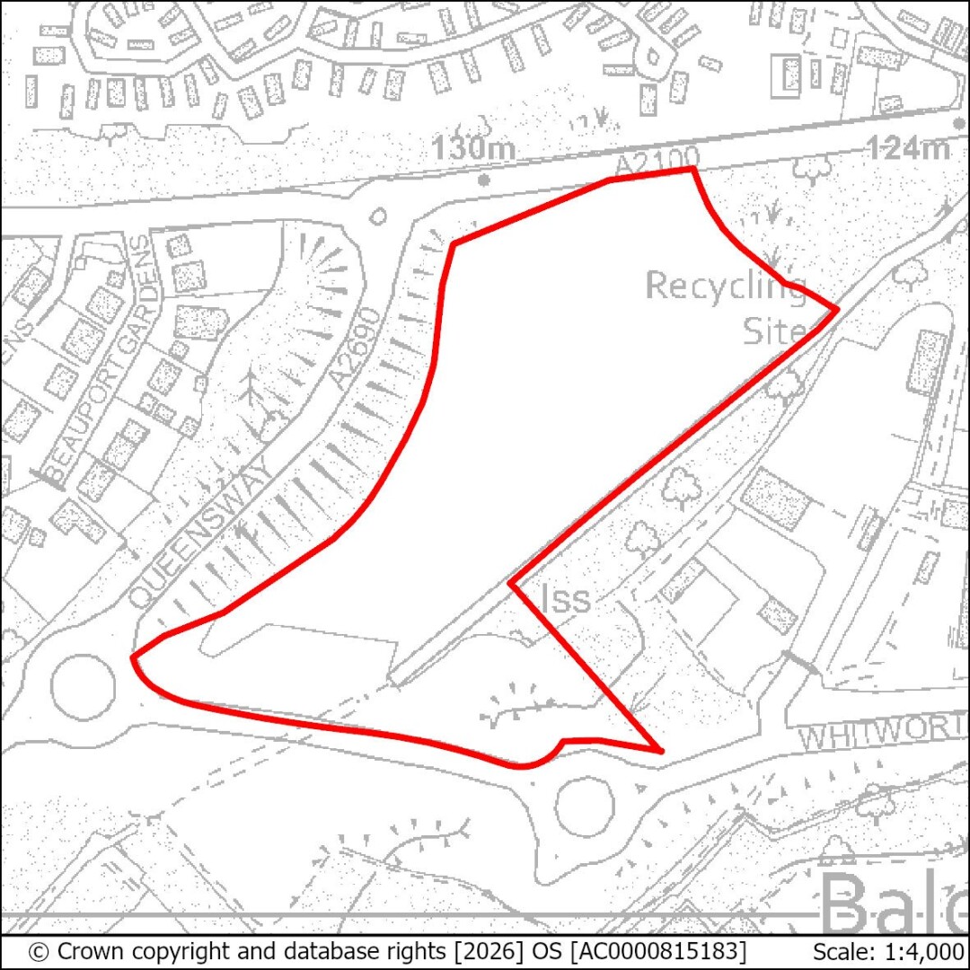
Policy ES8: Land at the junction of The Ridge West and Queensway
Use: Employment
Minimum Indicative Capacity (minimum floorspace): 4,700sqm
Site area: 2.95ha
Proposals for development on this site should:
- be designed in a way that contributes positively to the intensification of SIEA1;
- Be supported by an Ecological Impact Assessment (EcIA) and include an Ecological Constraints and Opportunities Plan (ECOP) and incorporate appropriate conservation and mitigation measures as recommended by the EcIA. The ECOP must make specific reference to the presence of nearby Sites of Special Scientific Interest (SSSI), TPO trees, Impact Risk Zones for all potentially affected SSSI, the results of site surveys of ES8 itself, and to other nearby areas of wildlife sensitivity;
- include measures to conserve and enhance the setting of the High Weald National Landscape;
- include a lighting plan to minimise light spill to nearby areas of wildlife sensitivity including the adjacent Local Wildlife Site;
- include boundary landscaping to act as a buffer to Queensway and The Ridge;
- provide an Arboriculture Plan that demonstrates how existing trees on site will be integrated into the development, or their loss will be compensated for including the existing tree belts running through the centre of the site;
- include a Flood Risk Assessment and demonstrate how the proposal will deliver flood resilient design based on the recommendations of this report. Site appropriate SuDS and surface water management measures should be identified as part of this process, taking into account the impact on watercourses, culverts, SSSI Impact Risk Zones and groundwater pollution vulnerability. Hydrological and hydrogeological monitoring should inform the drainage plans for this site.
- include appropriate active and sustainable travel infrastructure;
- be supported by a Transport Assessment and Travel Plan following a vision led and validate approach. The Transport Assessment must take account of the site’s proximity to The Ridge and the A21. Proposals must also indicate how the conclusions and recommendations of the Assessment have been incorporated within the development proposal and include arrangements to implement a monitor and manage approach to mitigation Development may be required to contribute to transport improvements on The Ridge or the A21 in advance of occupation;
- investigate the impact of ground behaviour and land stability, including the impact on existing structures, and incorporate remediation or mitigation measures as appropriate;
- investigate the potential for contamination within or effecting the site, and incorporate remediation or mitigation measures as appropriate;
- be designed to avoid or, where this is not possible, mitigate the impact of potential pollution and environmental hazards to the environment, occupiers and neighbours;
- Proposals must take into account the Waste Consultation Area that affects the site and propose suitable mitigations for any negative impacts arising or potentially arising from nearby waste processing, taking into account odour, noise or vibration, to be advised by the Waste Planning Authority.
- investigate the potential to make navigable connections to housing estates at Beauport Home Farm and Harrow Lane and the public open space to the south at Whitworth Road by improving footpath access;
- provide policy compliant green and blue infrastructure within the site;
- Provide a connection to the sewerage system at the nearest point of adequate capacity, as advised by Southern Water and ensure future access to the existing sewerage and water supply infrastructure for maintenance and upsizing purposes. Ensure that any necessary reinforcement of the water and/or wastewater network is in place to accommodate the quantum and type of proposed development prior to connection, and that such reinforcement is agreed with Southern Water. This will be secured by condition. Early engagement with Southern Water is also recommended;
- Take account of Southern Water's underground infrastructure in the design of the layout of the site. Easements would be required, which may affect the site layout or require diversion, and these should be clear of all proposed buildings and tree planting.
Policy ES10: Marline Fields, Enviro21 Business Park, Land West of Queensway Comment
6.247The site occupies a prominent position in SIEA1, and is accessed from A2690 Queensway with strong links to both the A259 (Brighton-Ashford) and the A21 (London). This site is the second phase of the Enviro21 Business Park and has been cleared and prepared for development and has good access through the existing spine road. It is capable of accommodating an extension to the existing park. The site also has strong potential to accommodate low carbon technologies as part of any development, including solar PV and the potential for small scale wind generation as part of any scheme may also be explored.
6.248The site is adjacent to a Site of Special Scientific Interest and Local Wildlife Site, with Ancient Woodland and a Local Nature Reserve nearby. These designated areas must be specifically referenced in any Ecological Constraints and Opportunities Plan (ECOP), and the site itself should be thoroughly surveyed to identify constraints. Due to the site sitting within the Impact Risk Zone (IRZ) for the Marline Valley Woods SSSI, Natural England should be consulted at the earliest possible stage.
6.249Any development proposal must seek to avoid or minimise impact on these areas during both the construction and occupation phases of the development, particularly the hydrological effects of drainage into the Marline Valley Stream. The introduction of pollutants to the highly vulnerable groundwater aquifer within the site should likewise be avoided during both phases. The cumulative impacts of development within the IRZ should also be considered. Development proposals should seek to avoid breaching the underlying sandstone layer.
6.250The site slopes away steeply towards the SSSI to the West and occupies a relatively high position within the valley. Due to these characteristics and the base geology, investigations of ground behaviour and land stability should take into account the hydrology and hydrogeology of the site, and a detailed stability report will be required. Proposals for SuDS that include attenuation may be appropriate subject to hydrological, hydrogeological and ground behaviour assessments.
6.251A lighting plan will be required due to the close proximity to areas of wildlife sensitivity and must demonstrate how steps have been taken to reduce light spill that may impact on these areas. An arboriculture plan must also be provided to set out how existing trees will be either integrated into the proposal, or their loss will be compensated for. The site has a natural tree boundary that should be retained and enhanced where possible. The ECOP, lighting plan and arboriculture plan can all form part of the same document if appropriate.
6.252Due to the size of the site, a Flood Risk Assessment will be required. This must take into account the risk of surface water flooding and incorporate mitigation measures as appropriate.
6.253Development proposals will need to show consideration of the transport impact and provide a transport assessment and a travel plan, following a vision-led approach. Improvements to better support access to the site through public and sustainable transport will be required, including consideration of improvements to the pedestrian connection to Napier Road and footpath Hastings 34a.
Figure 38: Marline Fields, Enviro21 Business Park, Land West of Queensway
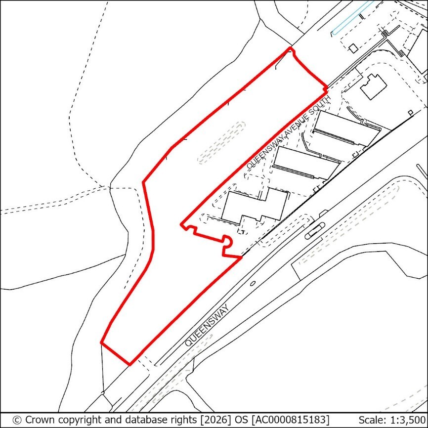
Policy ES10: Marline Fields, Enviro21 Business Park, Land West of Queensway
Use: Employment
Minimum Indicative Capacity (minimum floorspace): 550sqm
Site area: 1.48ha
Proposals for development on this site should:
- Demonstrate an approach that is SuDS-led to design and layout, which should take into account the results of any hydrological and groundwater monitoring to ensure negative impacts on the Marline Valley Woods SSSI can be avoided.
- be designed in a way that contributes positively to the intensification of SIEA1 while maximising onsite greenspace;
- Be supported by an Ecological Impact Assessment (EcIA) and include an Ecological Constraints and Opportunities Plan (ECOP) and incorporate appropriate conservation and mitigation measures as recommended by the EcIA. The ECOP must make specific reference to the presence of the adjacent Site of Special Scientific Interest (SSSI), the results of site surveys of ES10 itself, and to other nearby areas of wildlife sensitivity.
- include a lighting plan to minimise light spill to nearby areas of wildlife sensitivity, including SSSI, Ancient Woodland and Local Wildlife Site;
- provide an Arboriculture Plan that demonstrates how existing trees on site will be integrated into the development, including the existing tree belts running through the centre of the site, and at the western boundary;
- include a Flood Risk Assessment, and demonstrate how the proposal will deliver flood resilient design based on the recommendations of this report, taking into account the impact on the Marline Valley Stream, the SSSI and groundwater pollution vulnerability. Hydrological and hydrogeological monitoring using trail pits and/ or boreholes should inform the drainage plans for this site. Site appropriate SuDS and surface water management measures should be identified as part of this process;
- include appropriate active and sustainable travel infrastructure, maximising walking , wheeling and cycling links, as well as appropriate access to public transport;
- be supported by a Transport Assessment and Travel Plan, following a vision led and validate approach. The Transport Assessment must take account of the site’s proximity to The Ridge. Proposals must also indicate how the conclusions and recommendations of the Assessment have been incorporated within the development proposal and include arrangements to implement a monitor and manage approach to mitigation;
- investigate the impact of ground behaviour and land stability and incorporate remediation or mitigation measures as appropriate;
- investigate the potential for contamination within or effecting the site, and incorporate remediation or mitigation measures as appropriate;
- be designed to avoid or, where this is not possible, mitigate the impact of potential pollution and environmental hazards to the environment, occupiers and neighbours;
- investigate the potential to make navigable connections to Napier Road and the SSSI by improving footpath access and crossing points;
- provide policy compliant green and blue infrastructure within the site.
