
Hastings Local Plan Pre-Submission Version 2023-2041 (Regulation 19) September 2026
5. Development Potential Areas and Regeneration Areas Comment
5.1As part of the council’s overall spatial strategy, a number of areas have been identified that have the potential to deliver larger scale or locally important growth.
5.2Unlike site allocations, these areas are at an earlier stage of consideration and require some additional steps to be taken to fully understand their development potential, including site investigation and detailed master planning.
5.3This section introduces one Development Potential Area and two regeneration areas.
5.4The Development Potential Area, Land at Breadsell, is a location that straddles the boundary with neighbouring Rother to be investigated to understand its potential.
5.5The two Regeneration Areas are Hastings Central Regeneration Area, which is a location identified for large-scale regeneration and Land at St John’s Road Regeneration Area, which is identified for rationalisation and enhancement of the existing railway access and play space while potentially incorporating other uses.
5.6Both Regeneration Areas require additional strategic interventions to maximise their regeneration potential.
Development Potential Area Policy 1 (D1): Land at Breadsell Comment
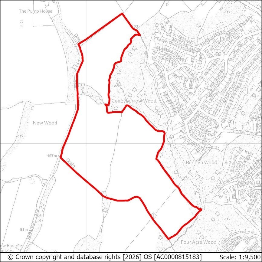
5.7This greenfield location adjacent to the High Weald National Landscape (Figure 2) extends to approximately 16 hectares in the northwest of Hastings. The northern part of the area, approximately 4.17 hectares falls within Rother District. The larger area, around 12 hectares, lies within Hastings Borough. To the west, the land abuts Breadsell Lane, and to the north, the land adjoins Hastings Road (A2100).
5.8As the suitability of development is subject to further technical assessment, the land is identified as a Development Potential Area.
5.9Breadsell Lane along the eastern boundary of this location abuts the High Weald National Landscape. The northern fields are separated from those to the south by a wooded shaw, which extends west of Coneyburrow Wood. The southern fields are enclosed, with Coneyburrow Wood and Birchen Wood to the north-eastern boundary, leading to Four Acre Wood within the lower valley side to the east, all of which are designated Ancient Woodland and form part of the Marline Valley Wood Site of Special Scientific Interest (SSSI) associated with a watercourse, the Marline Stream. The whole location site is within the Impact Risk Zone (IRZ) for the SSSI.
5.10Physical features include mature native hedgerows, agricultural drainage ditches, overhead electricity lines and the Borough’s high pressure gas main.
5.11Development here means that impact on the Marline Valley Woods SSSI is a key issue that goes to the heart of the suitability of this location for development. Investigations to date have established that a significant amount of ecohydrological and geohydrological monitoring is required in order to establish the acceptability of the principle of development at this location.
5.12The 2009 Rigare Study ‘scoping level hydrological and hydrogeological assessment of a proposed housing development site, Breadsell Lane, Hastings’, indicates that development would likely lead to impacts upon the Marline Valley Woods SSSI. The report sets out that significant work is required to understand how development would impact the SSSI which will require a period of ecohydrological and geohydrological monitoring.
5.13Proposals to develop the site for any use will be required to demonstrate that appropriate ecohydrological and geohydrological monitoring of the SSSI has been undertaken in accordance with a monitoring programme which is agreed between Hastings Borough Council and Natural England and identifies the conditions required to support the existing ecosystem as well as a scheme of mitigation which replicates the current conditions in perpetuity.
5.14The groundwater aquifer is identified as being highly vulnerable to the introduction of pollutants and any risk of this will need to be designed out both construction and occupation phases, with cumulative impacts of development within the IRZ considered insofar as this is possible. Development proposals should avoid breaching the underlying sandstone layer.
5.15Due to its location within the setting of the High Weald National Landscape (HWNL), the site will require a comprehensive Landscape Visual Impact Assessment (LVIA) to adequately assess the impact of any proposal on the National Landscape. The LVIA’s findings must inform the design of a landscape-led masterplan for the site that responds positively to the site's topography and the surrounding land, and incorporates any necessary mitigation measures, including those related to site hydrology and groundwater.
5.16The entire area lies within a defined ACIB of the East Sussex and Brighton and Hove Local Nature Recovery Strategy (LNRS). Proposals for this site should therefore contribute towards measures to create new habitat adjacent to protected sites, to create new wildlife corridors, and to create new and protect and enhance existing woodland. As well as ecohydrological and groundwater (geohydrological) considerations, significant buffers will be required to minimise any additional impacts associated with development, including but not limited to, increased recreational pressure, light pollution, garden escapes and invasive non-native species, and increased predation by domestic pets.
5.17The identified potential access is located within neighbouring Rother District. Work will be required to ensure the site is fully accessible and any access is capable of meeting acceptable highways standards.
5.18The council considers that a masterplan should be submitted and approved by the Local Planning Authorities prior to a planning application for development coming forward.
Figure 2: Land at Breadsell.
Development Potential Area Policy 1 (D1): Land at Breadsell
Use: Residential
Indicative Capacity (net additional dwellings): 200-300
Site Area (net developable): 12.03ha
In order to establish the acceptability of the principle of development on this site, it will be necessary to undertake an assessment of the ecological impact of any proposed development on the adjacent Marline Valley Woods SSSI. This must include the results of an agreed monitoring programme of the adjacent SSSI which sets out the requirements of the species and habitats contained within. The results of the programme must identify mitigations to replicate the current conditions within SSSI to avoid any undue harm to the protected site.
Should the principle of development be established, prior to the submission of a proposal for the development of the site, a Masterplan should be agreed with the Local Planning Authorities. The Masterplan should be informed by informed by relevant technical evidence and take into account the advice within the High Weald AONB Housing Design Guide, with regard to the policy requirements set out below.
Proposals for development on this site should:
- Take a SuDS-led and landscape-led approach to design and layout, which should maximise greenspace and take into account the results of any hydrological and groundwater monitoring to ensure negative impacts on the Marline Valley Woods SSSI will be avoided and/ or mitigated. This must be guided by:
- The results of hydrological and groundwater monitoring which must be informed by trial pits and/or boreholes;
- The need to avoid breaching the underlying sandstone layer during the preparation, construction and occupation phases (save for the purposes of (a) above);
- The results of a comprehensive Landscape Visual Impact assessment (LVIA) which must assess the impact of the proposal on the nearby National Landscape and incorporate mitigation measures where required.
- Provide affordable housing in line with Policy SP2;
- Be supported by an Ecological Impact Assessment (EcIA) and Ecological Constraints and Opportunities Plan (ECOP), and incorporate appropriate conservation and mitigation measures as recommended by the ECOP. The ECOP must make specific reference to the presence of onsite and nearby Sites of Special Scientific Interest (SSSI), Ancient Woodland, Impact Risk Zones for all potentially affected SSSI, the results of site surveys of D1 itself, and to other nearby areas of wildlife sensitivity. The EcIA should recommend appropriate buffers for areas of ecological sensitivity. Opportunities for enhancement should have regard to the LNRS;
- Ensure scheme and construction access is via A2100 subject to agreement with relevant bodies;
- Maintain and enhance the existing hedgerows within site excluding where access is required which should be reprovided elsewhere on the development site;
- Provide a lighting plan for both the construction and occupation phases of the proposed development, with regard to the High Weald National Landscape Dark Skies TAN to minimise adverse impacts on the National Landscape and nearby areas of wildlife sensitivity, including the SSSI. The plan should include measures to prevent overspill from internal lighting. The lighting plan must be agreed before permission is granted.
- Provide publicly accessible open space and natural, unfenced multifunctional play space. Open space and play will be secured in perpetuity by legal agreement;
- Include a maintenance and management plan for areas of publicly accessible open space and play;
- Create a layout which incorporates a landscape buffer zone along the boundary of the site, the tree and hedgerow belt in the southern fields, adjacent to the Marline Valley Woods SSSI and areas of Ancient Woodland.
- Consult relevant historic environment records and assess heritage assets using appropriate expertise including, where necessary, a field evaluation.
- Provide a connection to the sewerage system at the nearest point of adequate capacity, as advised by Southern Water and ensure future access to the existing sewerage and water supply infrastructure for maintenance and upsizing purposes.
- Ensure that any necessary reinforcement of the water and/or wastewater network is in place to accommodate the quantum and type of proposed development prior to connection, and that such reinforcement is agreed with Southern Water. This will be secured by condition. Early engagement with Southern Water is also recommended.
- Ensure vehicle access meets acceptable highways standards;
- Be supported by a Transport Assessment and Travel Plan. The Transport Assessment must take account of the site's proximity to The Ridge. Proposals must also indicate how the conclusions and recommendations of the Assessment have been incorporated within the proposal;
- Include walking and cycling links to ensure local connectivity, including to local community infrastructure, green spaces and public transport provision, taking into account site topography.
Regeneration Area Policy 1 (R1): Hastings Central Comment
5.19Hastings Town Centre is positioned at the top of the Borough’s retail hierarchy and is materially larger in terms of floorspace than the other town centres in the Borough. It includes around 550 non-residential public and private premises including shops, offices, educational space, leisure uses, visitor accommodation and municipal buildings, all set within a square mile. It is the physical, economic and social ‘heart’ of Hastings, sustaining more than 20% of the town’s jobs (c.6,000 jobs), it performs an important retail role in the sub-region, and includes the Town’s main transport hub.
5.20Located between the town centres of The Old Town to the east and St Leonards to the west, these two centres provide a complementary role to Hastings Town Centre. Collectively these centres, with their distinctive characters, offer a diverse range of shopping and leisure experiences.
5.21Significant regeneration has taken place in the town centre since 2000s with the delivery of office, education and health facilities and a new railway station. More recently has been the success of the Trinity Triangle Heritage Action Zone (HAZ) located in the eastern part of the Town Centre boundary.
5.22A catalyst for the continued regeneration of the Town Centre is the Town’s Fund programme, running to 2026. The investment provided by the Towns Fund will see the revival of Hastings Town Centre with investment in key heritage assets, buildings in the town centre and improvements in the public realm. To continue driving the regeneration of the Town Centre throughout the Plan period, the council will develop a dedicated regeneration plan as part of Pride in Place. With £20 million in endowment-style funding already confirmed from the government, the plan will set out local priorities identified through extensive engagement with communities across the borough, supporting long-term, locally led regeneration through to 2034.
5.23The regeneration activity already delivered through the Town’s Fund (to 2026) has created opportunities to further invest in the Centre that reflect the council’s wider, long-term ambitions. A critical part of taking the regeneration of the Town Centre forward, in addition to the policies set out here, is the continued collaboration between the council and Homes England on specific sites within the town centre. This partnership is expected to remain central to the delivery of regeneration initiatives, including as the new Sussex Mayor comes into power in May 2028. Working in partnership, the council aims to coordinate and manage key interventions and unlock wider investment opportunities from both the public and private sectors.
5.24Shopping habits are changing, and Hastings Town Centre needs to continue to change and evolve. Our retail needs assessment shows very low growth forecast for retail needs in Hastings over the coming years, and the same study indicates that the strategy for both convenience and comparison goods floorspace in Hastings should instead be focused upon making qualitative improvements to the town centre offer. Similarly, whilst there is a modest amount of growth expected for net additional food and beverage floorspace, this can be accommodated via the general turnover of units in the town centre and encouraging provision in redevelopment schemes in the centre.
5.25As well as changes to high street retailing, the Plan needs to take in to account other issues such as new ways of working, and a pressing need for more homes. Taken together, these factors can be harnessed to support Hastings town centre over the Plan period. The council wants to encourage a mix of uses in appropriate locations which will ensure the Town Centre remains vibrant and attractive to residents, visitors and investors. The vision is to build on the strengths of the town centre; to make it an even more attractive place to live, work and visit; to offer a town centre experience that cannot be found online, and to encourage a thriving daytime, evening and night-time economy.
5.26The council has identified a number of regeneration sites which offer potential for redevelopment or conversion. This includes a range of sites in terms of cleared sites ready for development, vacant and currently occupied buildings:
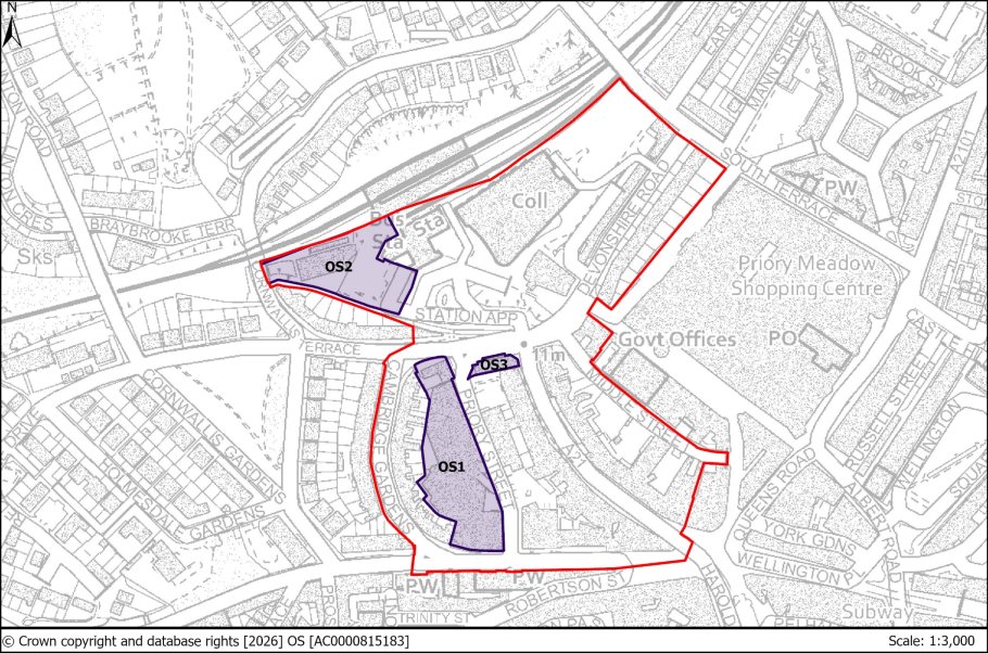
Figure 3: Station Area, showing opportunity sites.
Station Area
5.27This area includes Hastings Railway Station and Priory Quarter which has been the focus for education and office development adjacent to the station and extending along Havelock Road. Significant regeneration has taken place in this area since 2000. The council wants to see the regeneration of this area continue, including the redevelopment of Queensbury House and Priory Street, to create new economic and residential spaces.
5.28The whole area has the potential to act as an attractive gateway to Hastings. Opportunities exist for public realm improvements, and the reconfiguration of public spaces, enhancing this area’s offer as a pedestrian hub and as an important access point to the town centre. There is potential to create linkages to the wider Town Centre area.
5.29The council will work with developers and partners to bring forward mixed use development and public realm improvements.
5.30Development will need to address the following key objectives:
- Improving town centre connectivity;
- Delivering new and enhanced employment generating uses;
- Support the regeneration of Hastings Town Centre through provision of land uses that complement the main town centre uses;
- Create high quality homes in the heart of Hastings.
5.31The Gateway area contains three opportunity sites as shown in Figure 3:
- OS1: Priory Street Car Park, ESK and Gizmo
- OS2: Station Approach car park and Royal Mail Delivery Office
- OS3: Queensbury House, Havelock Road
5.32Table 6 sets out Council’s anticipated uses for these sites. Policy R1 sets out the strategy and guiding principles for their redevelopment. In line with the flexibility established within Policy R1, the council is expecting significant intensification to be achieved in Hastings town centre.
Table 5: Station Area sites and anticipated uses
|
Site Ref |
Site Name |
Potential uses and indicative capacity |
|
OS1 |
Priory Street Car Park, ESK and Gizmo |
This site offers strong potential for mixed-use development and intensification. Its proximity to the primary shopping area, transport hub and further education facilities, means it could provide a range of employment spaces, and other town centre uses such a leisure. Residential use, as part of a mixed-use development, would also be suitable. A high-quality design and public realm improvements will be important along with active frontages to Priory Street and Cambridge Road. Proposals should take account of Southern Water's underground infrastructure in the design of the layout of the site. Easements would be required, which may affect the site layout or require diversion, and these should be clear of all proposed buildings and tree planting. Summary: Mixed use including residential, business, leisure c.10,000sqm of commercial space c.160 residential units |
|
OS2 |
Station Approach car park and Royal Mail Delivery Office |
This site is located next to the station plaza, and provides the opportunity to create an appealing, attractive gateway to Hastings. The site is capable of supporting a mixed-use scheme with retail, leisure and residential uses. Redevelopment of the Royal Mail site will have to take account of the relocation of its existing operation. Summary: Mixed use including retail, business and residential c.10,000sqm of commercial space c. 92 – 115 residential units |
|
OS3 |
Queensbury House, Havelock Road |
The redevelopment and/or reuse of this key gateway site has the potential to deliver a high-quality, tall landmark building that provides a range of business and commercial floorspace, including food and drink and residential. Proposals should take account of Southern Water's underground infrastructure in the design of the layout of the site. Easements would be required, which may affect the site layout or require diversion, and these should be clear of all proposed buildings and tree planting. Summary: Mixed use including business/leisure, and residential and retail c.4,000sqm of commercial space c. 20 – 40 residential units |
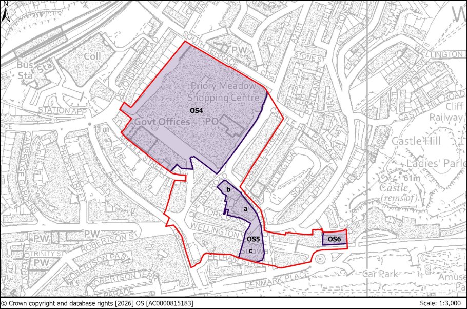
Figure 4: Hastings Central Plaza, showing opportunity sites
Hastings Central Plaza
5.33There continues to be an opportunity to revitalise the Town Centre’s primary shopping area, with additional investment in retail and leisure development particularly in key gateway locations closer to the seafront. This will encourage more shopping and leisure footfall to benefit the centre’s vitality.
5.34Hastings Central Plaza is an area of Hastings Town Centre (as shown in Figure 4), taking in the lower part of Queens Road, Wellington Place, Albert Road, Station Approach, Priory Meadow, Castle Street and Breeds Place. It is a busy shopping area. The streets are lively with shoppers and visitors attracted by the mix of multiple retailers and independent traders. There is a vibrant retail and leisure presence, including cafés and restaurants also have a strong presence. Castle Street is a key pedestrian gateway linking the seafront to the Town Centre Shopping Area.
5.35A key objective is to attract high quality commercial investment, increase pedestrian flows between the seafront and the primary shopping area and creating an attractive and vibrant shopping and leisure destination, increasing dwell time and drawing residents and visitors from a wide catchment. Residential uses on upper floors and community related uses may also be appropriate as part of mixed-use development schemes.
5.36This regeneration area has the potential to provide an enhanced leisure, cultural and entertainment offer. The look and feel of the area needs to be reinvigorated to create a high-quality destination attracting new investment as well as visitors. The public realm needs to be enhanced and where possible, trees and other nature-based solutions incorporated to soften the hard landscaping, providing shade and capturing surface water close to the source.
5.37New development in this area should:
- improve the quality and variety of town centre uses;
- deliver high quality design and associated public realm;
- redevelop key sites to increase capacity within the town centre;
- raise the overall standard of design, including shopfront design, creating attractive and vibrant streets.
5.38The following sites have the potential to be redeveloped and are shown in Figure 4.
- OS5:
- Corner of Wellington Place and Albert Road
- Cinema, Queens Road
- 1-7 Wellington Place
- OS4: Priory Meadow
- OS6: Muriel Matters House, Breeds Place
5.39Table 6 sets out Council’s anticipated uses for these sites. Policy R1 sets out the strategy and guiding principles for their redevelopment.
Table 6: Hastings Central Plaza sites and anticipated uses
|
Site Ref |
Site Name |
Potential uses and indicative capacity |
|
OS5a |
Corner of Wellington Place and Albert Road |
This site is located in a prominent position within the Primary Shopping Area. The current building is divided between comparison retail floorspace and leisure uses. The building was originally developed as a large convenience store and is of poor design making a negative contribution to the streetscape and conservation area. To ensure the vitality of the town centre is maintained and strengthened, the council will support the redevelopment or remodelling of this site to deliver an exciting building of high quality at the eastern end of Wellington Place, for retail or leisure use. Office or residential uses may be acceptable on upper floors as part of a mixed-use development. In addition, the redevelopment of site OS5(a) offers the potential to enhance the public space located at the junction of Albert Road and Wellington Place. This area currently lacks a clear function and detracts from the setting of Wellington Square and Hastings Castle. |
|
OS5b |
Cinema, Queens Road |
This site is located in a prominent gateway position within the Town Centre, connecting Priory Meadow’s central plaza with the wider centre and seafront, and is located within the primary shopping area. The building was constructed as the Gaiety Theatre and is a striking building in Italianate red brick and stone. It is currently operating as a cinema with a 4-screen multiplex facility. Leisure uses are an important element of the town centre, and the council will continue to support cinema provision at this site. The council will support the enhancement of cinema facilities on this site or as part of a mixed-use development scheme incorporating site OS5(a). In the event of the reprovision of the cinema on a suitable alternative site within the town centre, the council will support the redevelopment of the site to incorporate retail and leisure uses. Development proposals for this site: - should be predominantly for cultural, leisure or retail; - should seek to retain the existing building |
|
OS5c |
1-7 Wellington Place |
The redevelopment of this site will form an important part of the vision to transform this part of the primary shopping area into a high-quality destination enhancing this gateway location between the town centre and the seafront. The current building negatively impacts the town centre streetscape and conservation area. The council will support the redevelopment or remodelling of this site to deliver an exciting building of high quality that will act as an ‘anchor’ at the eastern end of Wellington Place. The redevelopment of this site together with Policy OS5(a) should raise design standards in this part of the town centre. Residential uses may be acceptable on upper floors as part of a mixed-use development scheme. The council will support the redevelopment of this site for a mix of uses including comparison retail, leisure provision, restaurant, café uses, and residential uses will be acceptable as part of a comprehensive scheme. The site provides the opportunity to deliver a new high quality landmark building marking the entrance to the town centre from the seafront. |
|
Summary: |
Mixed use including retail, residential, sport and leisure, cinema, food and drink. Proposals should take account of Southern Water's underground infrastructure in the design of the layout of the site. Easements would be required, which may affect the site layout or require diversion, and these should be clear of all proposed buildings and tree planting. c.3,500 sqm c. 84 – 105 residential units |
|
|
OS4 |
Priory Meadow |
Priory Meadow is located in the central part of the primary shopping area. It caters for comparison shopping and accommodates a high proportion of the Town’s national retailers. Maintaining the quality and variety of the retail offer will be important. So too is the need to encourage new leisure uses to attract people to the centre at different times of the day and evening. The council will explore with the centre owners and developers the opportunities to increase the quantity, quality and range of offer in the centre. This includes increasing storeys and potentially introducing residential and other town centre uses on upper storeys. Proposals should take account of Southern Water's underground infrastructure in the design of the layout of the site. Easements would be required, which may affect the site layout or require diversion, and these should be clear of all proposed buildings and tree planting. Summary: Mixed Use c. 130 residential units |
|
OS6 |
Muriel Matters House |
Muriel Matters House is a seafront multi-storey office building which offers potential for conversion or redevelopment. Retention of some office space is compatible with a variety of town centre uses including residential. Whilst an active ground floor frontage should be retained. Proposals should take account of Southern Water's underground infrastructure in the design of the layout of the site. Easements would be required, which may affect the site layout or require diversion, and these should be clear of all proposed buildings and tree planting. Summary: Mixed use c. 25 – 35 residential units |
Regeneration Area Policy 1 (R1): Hastings Central
5.40To support the council’s objective to promote economic growth, Policy R1 provides maximum flexibility to enable the delivery of new and mixed-use development with a focus on job creation with the objective of expanding the draw of the town beyond just traditional retail.
5.41Where these uses contribute to the vitality of the Town Centre, well designed, ‘meanwhile uses’, that is temporary changes to the use of a building, may have a role in supporting the area in the short to medium term. Residential development could also be part of the town centre mix.
5.42The historic townscape of the centre, with multiple listed buildings and Conservation Area status will require sensitive design and adaptive reuse. A fabric-first approach is essential to safeguard heritage assets while enabling contemporary uses. The compact nature of the Town Centre offers excellent accessibility by public transport and active travel. This creates high potential for intensification, with a significant uplift in average densities, adaptive reuse, and mixed-use development within existing built form. Sites within this area would benefit from a holistic and well-integrated masterplan approach.
5.43Given that tall development is likely to take place on some of these sites, it is also important to ensure that proposals include a views analysis to determine appropriate building height, massing, and the suitability of any taller elements.
5.44Growing the permanent residential community in Hastings Town Centre will contribute to the vitality and viability of the town centre, bringing people into the town at different times of the day, increasing footfall and supporting a more vibrant evening and night time economy.
5.45It will be important however, to provide a balance between protecting the town centre from the loss of those characteristics which make it a vibrant town centre and encouraging more residential development. Residential uses at ground floor level within the primary shopping area would be harmful to the overall vitality of the centre, both in terms of fragmenting retail and commercial uses, and also by creating incompatible living conditions for potential occupiers by compromising residential amenity.
5.46Hastings Town Centre is inhibited by transport and public realm issues. Parts of the primary shopping area have been pedestrianised, but there is a lack of consistency in design, use of materials, and street furniture. Improving the attractiveness and useability of the public realm in conjunction with changing our approach to parking in an area with high transport accessibility is key part of our strategy.
5.47Policy R1 sets out the council’s strategy for revitalising Hastings Town Centre.
5.48The Policy sets out the council’s strategy for Hastings Town Centre and is intended to act as a guide to inform the design and delivery of new development. Not all of the criteria will be relevant to every development proposal. In line with the flexibility established within Policy R1, the council strongly encourages pre-application engagement to establish suitable uses for each of the identified sites.
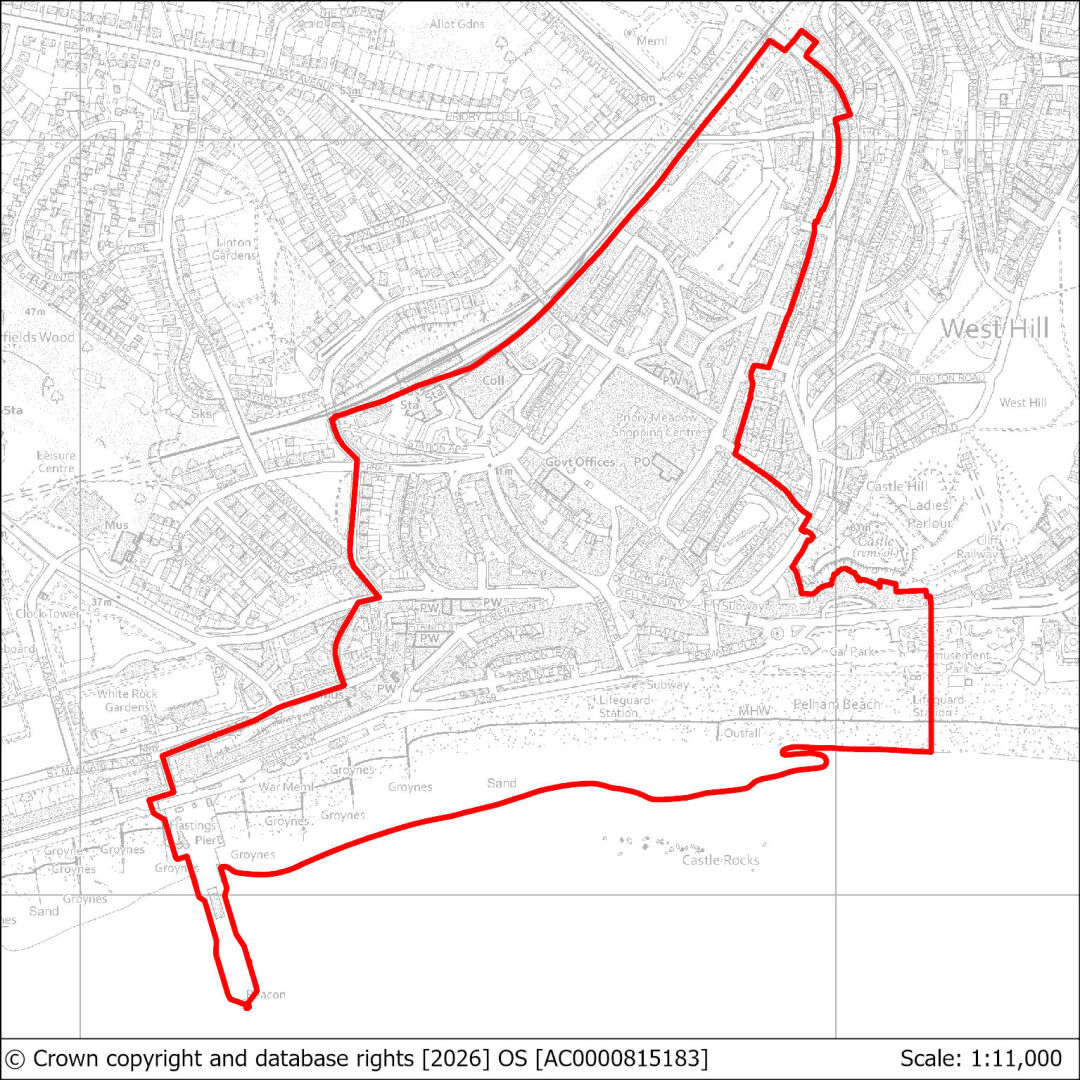
Figure 5: Hastings Central Regeneration Area
Regeneration Area Policy 1 (R1): Hastings Central
Development proposals within the Hastings Central Regeneration Area should be underpinned by an understanding of the significance of surrounding heritage assets. The council will support a variety of land uses in Hastings Central to encourage a mixed-use vibrant town centre and will support the development of:
- Employment generating uses, including: retail, office, light industry, studios, leisure, cafés, restaurants, visitor facilities (including hotels), education facilities and where appropriate drinking establishments.
- Residential uses, including student accommodation for institutions located in Hastings and Rother, providing they do not prejudice the commercial function of the area. In the Primary Shopping Area, residential uses will only be acceptable at first floor level and above.
- Non-residential Uses that support active frontages at ground level to enliven the street environment
- Opportunity sites have been identified in the Station Area and the Hastings Central Plaza. These sites provide the opportunity for intensification and expansion to enhance the retail and leisure offer, support the local economy, promote tourism and provide residential accommodation. There is the potential for this to be supported through the development of a Hastings Central Regeneration Area Design Guide during the Plan period.
General Principles
New development should make a positive contribution to improving the town centre. This includes improving the viability and vitality, supporting the creation of a safe, attractive, accessible and high-quality environment through a variety of places and spaces for social interaction, improving the overall mix of land uses and enhancing connectivity, both within the centre and to adjoining areas. This will be achieved by:
- Requiring all schemes to demonstrate a quality of design that makes a positive contribution to the character of the Town Centre, including proposed buildings and the public realm.
- Ensuring the most effective use of land through the promotion of high-density development where appropriate, and the redevelopment of cleared, vacant or underused sites to increase commercial capacity within the Town Centre.
- Improving the connectivity and legibility between the different areas of the Town Centre, including the seafront.
- Recognising the rich historic environment in the Regeneration Area, ensuring that proposals conserve and where appropriate enhance the significance of nearby designated heritage assets.
- Consult relevant historic environment records and assess heritage assets using appropriate expertise including, where necessary, a field evaluation.
- Raising the quality of streets and public realm including enhance the quality of the natural environment by investing in and establishing new green and blue infrastructure, having regard to the opportunities identified through the LNRS.
- The introduction of residential uses as part of commercial-led mixed-use development to support and sustain the vibrancy of the town centre and the evening economy.
- Improving pedestrian and cycle access, traffic circulation and management.
5.49The Policy sets out the council’s strategy for Hastings Town Centre and is intended to act as a guide to inform the design and delivery of new development. Not all of the criteria will be relevant to every development proposal. In line with the flexibility established within Policy R1, the council strongly encourages pre-application engagement to establish suitable uses for each of the identified sites.
Regeneration Area Policy 3 (R3): St Johns Road Comment
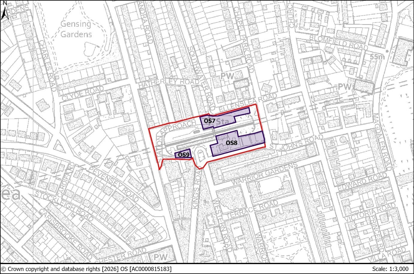
5.50The St John’s Road Regeneration Area totals 1.61ha and comprises land in and around Warrior Square Station, including a former Taxi office and café, the north and south station concourse, and equipped play area. The site fronts St John’s Road, London Road, Chapel Park Road and Ellenslea Road and provides an opportunity for comprehensive regeneration in a highly sustainable location.
5.51Part of the location slopes steeply east to west and includes areas of terracing supported by retaining structures. There is a sharp difference in levels at the Chapel Park Road frontage where the site crosses the Hastings – St Leonards railway tunnel, and several other incidences of level changes within the boundary. It is within the Kings Road Conservation Area and partially within the St Leonards District Centre.
5.52As a key gateway into and out of St Leonards, a landmark development enhancing the views from Kings Road and the wider Conservation Area would be appropriate for this location. Similarly, there is potential to reprovide or improve the equipped play area to provide stronger links to the station and the District Centre.
5.53The station itself requires improvement to ensure high quality step free access to both platforms. In addition, any redevelopment proposal should seek to strengthen sustainable transport and multimodal links to and from the location.
5.54There is an opportunity to rationalise and improve the relationship of the station itself to the London Road including improvements or layout changes to vehicle and footpath access which has accessibility challenges and lacks natural surveillance. There is the potential for residential-led, mixed use development along St John’s Road and south of Ellenslea Road subject to reaching agreement with landowners and other stakeholders within or adjacent to the area. Proposals will need to take into account loading capacities, easements and the need to avoid impacting the integrity and operation of the railway and its associated tunnels.
5.55Due to the prevalence of impervious surfaces, the location is vulnerable to surface water flooding. Redevelopment will provide an opportunity to improve flood risk attenuation measures, such as urban greening factor interventions and the introduction of new green and blue infrastructure. It should be noted that part of the site lies within an ACIB of the East Sussex and Brighton & Hove Local Nature Recovery Strategy (LNRS), with mapped measures for nature networks.
Table 7: Opportunity Sites in Regeneration Area 3
|
Site Ref |
Site Name |
Potential uses and indicative capacity |
|
OS7 |
Land south of Ellenslea Road |
This site currently serves as carparking for the station. Proposals should seek to retain parking within the Regeneration Area as a whole and consider innovative solutions to incorporate additional mixed and residential uses at higher elevations. |
|
OS8 |
Land north of St Johns Road |
This site is a sloping, terraced location comprised of most hardstanding and has the potential to incorporate mixed and residential uses. This area incorporates a play space of good quality but with poor relationship to the station and District Centre. Proposals for the Regeneration Area as a whole should consider how this relationship can be improved, either through relocation within the Regeneration Area or access improvements. |
|
OS9 |
Land south west of St Leonards Warrior Square Station |
This site is located in a prominent gateway position, connecting the area with Kings Road and London Road. The site has the potential to incorporate some element of mixed or residential use, and has potential as a sustainable location for a Day Nursery. |
5.56Any redevelopment proposals should:
- be prepared in association with relevant stakeholders and be informed by comprehensive and inclusive consultation and engagement with the wider community;
- be informed by a design and conservation statement enabling a detailed understanding of the wider Conservation Area and townscape context;
- be based on thorough ground investigation taking into account the railway network infrastructure in consultation with the railway authority;
- improve the overall connectivity, legibility and platform access for the station platforms and consider the future of the station buildings as part of the overall context of the location;
- adapt to and mitigate the effects of surface water flooding.
Figure 6: St Johns Road Regeneration Area
Regeneration Area Policy 3 (R3): St Johns Road
- A comprehensive approach is required for the redevelopment of the station and the area immediately surrounding it, that incorporates improvements to the accessibility, capacity and design of Warrior Square Station.
- As the area has the potential to support the Borough’s requirements for new housing, appropriate residential development is acceptable as part of the overall mix including the provision of affordable housing in line with Policy SP2. A variety of commercial and community uses may be acceptable for street level elevations and trackside.
- Ensure that all new homes meet the Council’s Net-Zero Carbon Homes standards in Policy SC3 and that the scheme includes other measures to mitigate the effects of climate change in particular measures for shading and cooling.
- Proposals should be in accordance with a Masterplan and development brief that has been prepared in conjunction with the Railway Authority and adopted by the Council.
- Proposals for development should consider the setting of the Kings Road conservation area and the prominent position of the station as a key gateway site and landmark building location.
- Proposals should be informed by agreed land stability and geotechnical reports prepared in conjunction with the Railway Authority covering the temporary, intermediate and permanent condition of the site, taking into account all dead and imposed loads and railway infrastructure.
- Include a maintenance and management plan for any new, retained or improved land stability mitigation measures to ensure they will be safe for their intended lifetime.
- Car free or low-car development will be acceptable subject to Policy ID2.
- Proposals should take into account the topography of the area.
- Proposals should retain or reprovide the play space and improve the access and connectivity to the station and District centre.
- Opportunities to mitigate, manage and adapt to surface water flooding through to protect the railway line and surrounding pedestrian access should be explored.
- Proposals should ensure that green and blue infrastructure and high scoring urban greening features are incorporated.
