
Hastings Local Plan Consultation Draft (Regulation 18)
Please note sites appear as far as possible in order of size and all site plans are subject to the following © Crown Copyright and database rights [2020]. OS [100021328]. Use of this data is subject to terms and conditions. You are granted a non-exclusive, royalty free, revocable licence solely to view the Licensed Data for non-commercial purposes for the period during which Hastings Borough Council makes it available. You are not permitted to copy, sub-license, distribute, sell or otherwise make available the Licenced Data to third parties in any form. Third party rights to enforce the terms of this licence shall be reserved to OS.
List of Sites (reference number followed by site name)
TC1 - Priory Street car park and ESK
TC2 - Station Approach car park and Royal Mail Delivery Office
TC4 - Debenhams building, Robertson Street
TC3 - Queensbury House, Havelock Road
TC5- The Observer building, 53 Cambridge Road
TC8 - Corner of Wellington Place and Albert Road; Cinema, Queens Road; 1-7 Wellington Place
TC6 - Former Post Office, Cambridge Road and former University of Brighton building, Priory Quarter
TC9 - Harold Place (site of former public conveniences)
TC10 - Cornwallis Street car park
HL80 - Ashdown House, Sedlescombe Road North
HL2 - Former Harrow Lane playing fields
HL7 - Former St Leonards Academy (Grove School), Darwell Campus, Darwell Close
HL112 - Land at corner of St Helens Down and playing fields of former Helenswood School
HL19 - Land adjacent to Sandrock Park, The Ridge
HL9 - Seaside Road, West St Leonards
HL84 - Pilot Field, Elphinstone Road
HL12 - Former Malmesbury House, West Hill Road
HL113 - Former Westerleigh School playing fields
HL35 - Hastings Station Yard (part)
HL3 - Land adjacent to 777 The Ridge
HL115 - Former West St Leonards Primary School, Bexhill Road
HL40 - Former Mount Pleasant Hospital, Frederick Road
HL39 - Ore Valley (Former Power Station)
HL4 – Mayfield E, Bodiam Drive
HL33 - Taxi office and former social club, St Johns Road
HL22 - Former Hollingsworth Garage, Braybrooke Road
HL11 - Cinque Ports Way (former Stamco timber yard and TA centre)
HL23 - 12-19 Braybrooke Terrace
HL111 - Gambier House, 111 West Hill Road and West House, 115 West Hill Road
HL101 - Priory Meadow, Queens Road (upper levels)
Small sites less than 20 units
Site reference: TC1 Site name: Priory Street car park and ESK
Focus Area/Strategic Policy: Focus Area 1: Hastings Central
Use: Commercial/employment led mixed use to complement the function of the town centre. Option to include residential uses potentially taking inspiration from creative development of multi-storey car parks in regeneration areas in other towns, which have ranged from incorporation of power league pitches, to pop up leisure, and start-up units
Indicative capacity (net residential dwellings/floorspace): 10,000sqm and up to 120 residential units
Site specific development considerations based on draft Local Plan policies:
Development on this site should:
- Enable better placemaking response at key point of arrival in the town, with associated scope to change perceptions
- Provide opportunity for creative year-round leisure focused development combining an innovative range of uses
- Provide an active frontage along Priory Street, and landmark building at corner with Cambridge Road to complement former post office building and Priory Square
- Provide active uses at ground floor level which should include retail, leisure or other 'town centre' complementary uses
- Improve public realm and support promotion as a secondary route to the town centre and Bohemia
- Retain an element of town centre car parking on this site as part of town provision subject to securing appropriate and safe access and servicing
- Preserve and enhance the setting of the conservation area, and long-range views of and from Hastings Castle
- Provide appropriate measures to mitigate the impact of noise on residential dwellings due to location within the active night-time economy setting
- Provide 25% affordable housing where new residential development is built in line with policy SP2
The following image shows a map of the site boundary.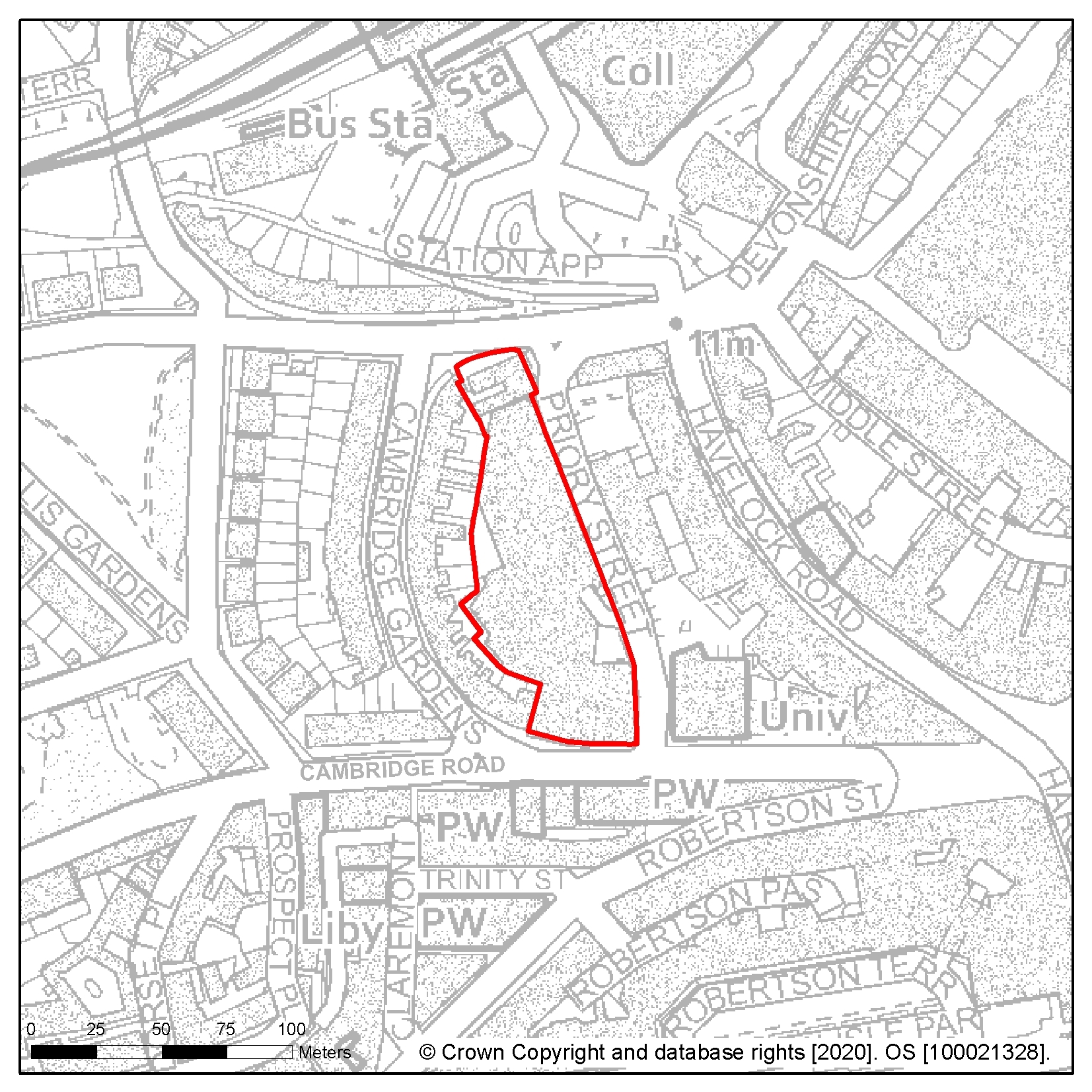
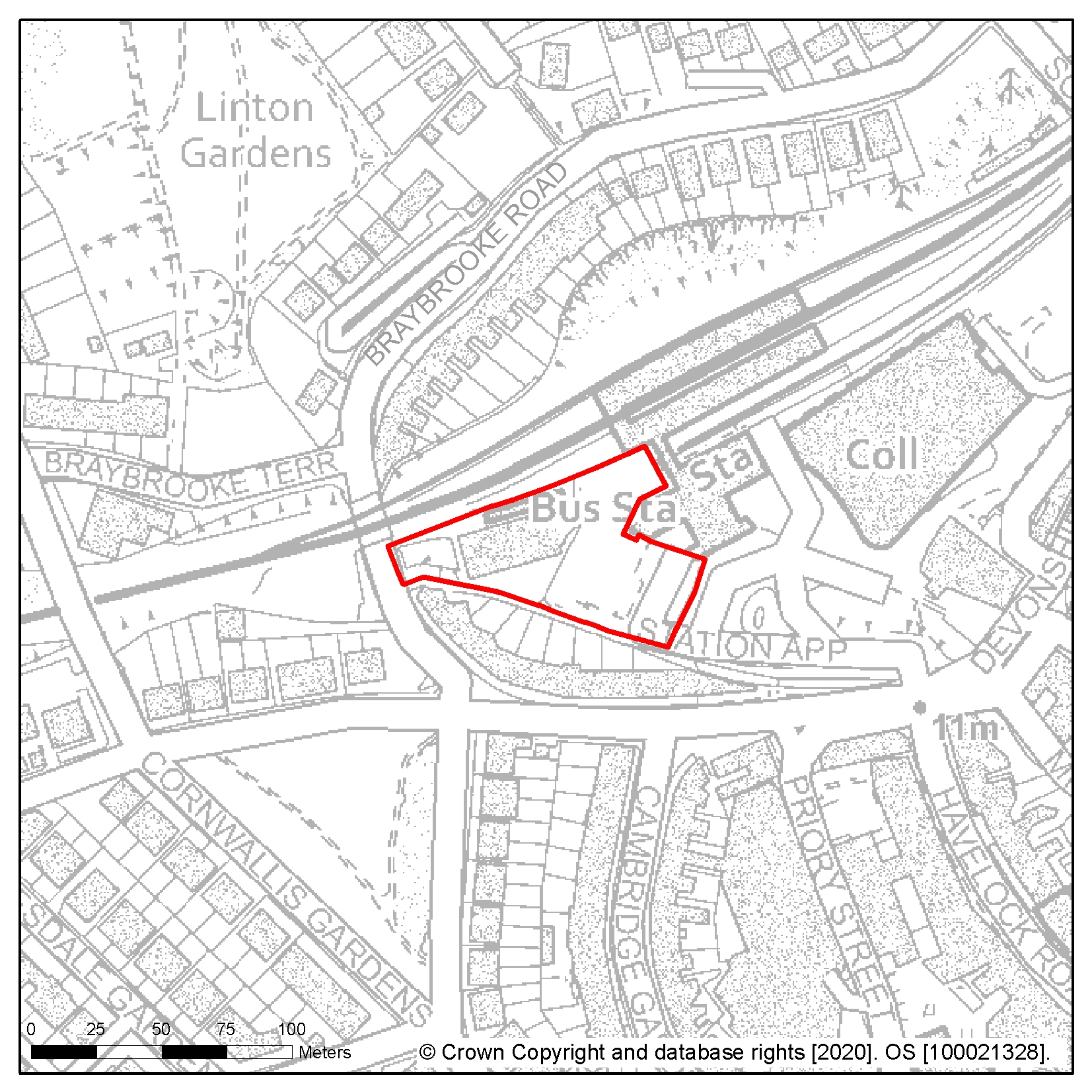
Site reference: TC2 Site name: Station Approach car park and Royal Mail Delivery Office
Focus Area/Strategic Policy: Focus Area 1: Hastings Central
Use: Commercial/employment led mixed use
Indicative capacity (net residential dwellings/floorspace): 10,000sqm
Site specific development considerations based on draft Local Plan policies:
Development on this site should:
- Help to mask the view of the rear of Cornwallis Terrace from the town square which is in front of the station
- Avoid adverse impact on the amenity of adjoining residents, particularly those in Braybrooke Road and Cornwallis Terrace
- Take account of Southern Water's underground infrastructure that crosses the site in the design of the site layout. Easements would be required, which may affect the site layout or require diversion, and these should be clear of all proposed buildings and tree planting
- Introduce policy compliant 'greening' to the site in a form appropriate to the urban setting
- Respond to the town square setting providing clear routes and secure some reconfiguration of existing station parking and pedestrian access routes to ensure a safe environment
The following image shows a map of the site boundary.
Site reference: TC4 Site name: Debenhams building, Robertson Street
Focus Area/Strategic Policy: Focus Area 1: Hastings Central
Use: Commercial/employment led mixed use to complement the function of the town centre. Option to include residential uses
Indicative capacity (net residential dwellings/floorspace): Up to 8,927sqm commercial floorspace and/or up to 50 homes
Site specific development considerations based on draft Local Plan policies:
Development on this site should:
- Retain, enhance and reuse the building to provide uses that continue to provide an anchor for Hastings Town Centre
- Make use of the property which comprises several interconnecting buildings with a double frontage onto Robertson Street to the north and Robertson Terrace to the south, totalling 8,927sqm of retail and ancillary floorspace
- Provide for active uses at ground floor level which should include retail, leisure or other 'town centre' complementary uses which might extend to the first floor given the building form, and the upper levels of the building would be suitable for residential or hotel uses
- Preserve and enhance the setting of the Hastings Town Centre Conservation Area, and long-range views of and from Hastings Castle
- Respond to the town square setting at memorial and Harold Place and public realm at Robertson Terrace, providing clear routes to the centre and the seafront
- Introduce policy compliant 'greening' to the site in a form appropriate to the urban setting
- Take appropriate measures to mitigate the impact of noise on residential dwellings due to its location within the active night time economy setting
- Provide 25% affordable housing where new residential development is built in line with policy SP2
The following image shows a map of the site boundary.
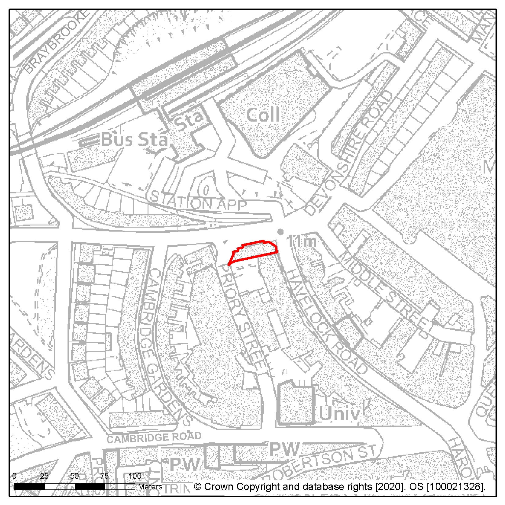
Site reference: TC3 Site name: Queensbury House, Havelock Road
Focus Area/Strategic Policy: Focus Area 1: Hastings Central
Use: Commercial/employment led mixed use. Option to include residential uses.
Indicative capacity (net residential dwellings/floorspace): 4,000sqm
Site specific development considerations based on draft Local Plan policies:
Development on this site should:
- Preserve and enhance the setting of the conservation area, and long-range views of and from Hastings Castle
- Support placemaking at key point of arrival in the town, with associated scope to change perceptions
- Provide strong active frontage including retail, leisure or other complementary use
- Improve public realm and support promotion of adjacent Priory Street as a secondary route to the town centre and Bohemia
- Take account of Southern Water's underground infrastructure that crosses the site in the design of the site layout. Easements would be required, which may affect the site layout or require diversion
- Introduce policy compliant 'greening' to the site in a form appropriate to the urban setting
- Take appropriate measures to mitigate the impact of noise on residential dwellings due to its location within the active night time economy setting of Havelock Road
- Provide 25% affordable housing where new residential development is built in line with policy SP2
The following image shows a map of the site boundary.
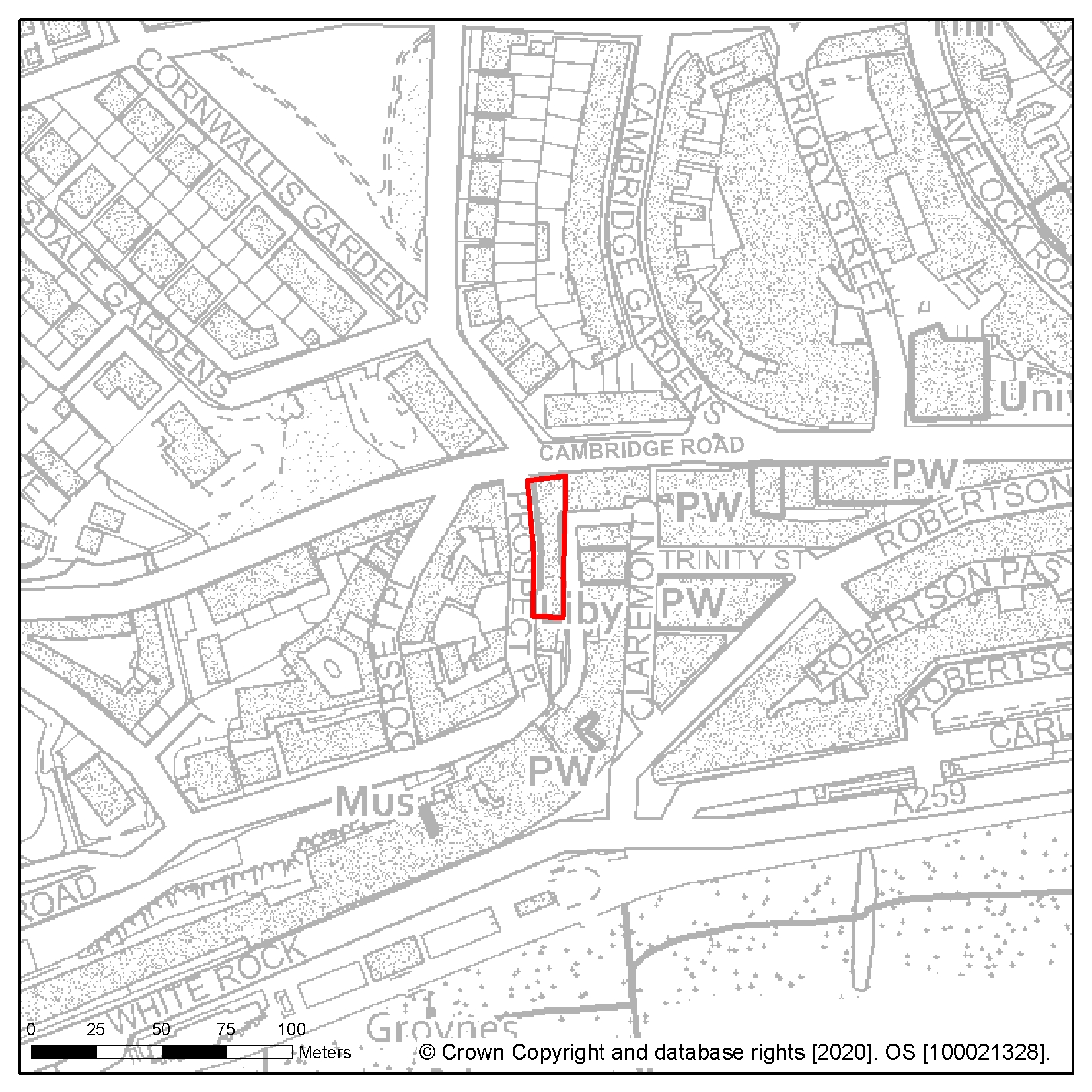
Site reference: TC5 Site name: The Observer building, 53 Cambridge Road
Focus Area/Strategic Policy: Focus Area 1: Hastings Central
Use: Commercial/employment led mixed use with priority uses including workspace for creative industries, cultural and/or education uses. Option to include residential uses.
Indicative capacity (net residential dwellings/floorspace): Up to 3,000sqm and minimum 16 homes
Site specific development considerations based on draft Local Plan policies:
Development on this site should:
- Give priority to uses that provide for an element of wider community access to an important historic building, although the existing building frontage may limit the degree to which active uses can be accommodated at street level
- Retain and secure the building frontage. Significant repair and renovation is required
- Enhance the setting of the conservation area, including views of and from Hastings Castle
- Introduce policy compliant 'greening' to the site in a form appropriate to the urban setting
- Enhance access to and the setting of existing urban outdoor space at Rock Alley to the south of the building
- Mitigate the impact of noise on residential dwellings with appropriate measures due to its location within the active night time economy setting of Cambridge Road
- Provide 25% affordable housing where new residential development is built in line with policy SP2
The following image shows a map of the site boundary.
Site reference: TC7 Site name: White Rock Park
Focus Area/Strategic Policy: Focus Area 2: Bohemia
Use: Sports/leisure. Option to include residential in line with FA2
Indicative capacity (net residential dwellings/floorspace): 3,000sqm
Site specific development considerations based on draft Local Plan policies:
Development on this site should:
- Create a vibrant focus for existing and new urban sports
- Retain woodland to the north of the site within the site of the old Bohemia Farm as part of the network of green spaces
- Incorporate new pedestrian and cycle route linking Magdalen Road to Falaise Road and Hastings Town Centre
- Preserve and enhance the setting of the Magdalen Road and Eversfield Place Conservation Areas, and heritage assets including the Former Convent of Holy Child Jesus.
- Take account of Southern Water's underground infrastructure that crosses the site in the design of the site layout Easements would be required, which may affect the site layout or require diversion, and these should be clear of all proposed buildings and tree planting
- Enhance pedestrian and cycle access to Central St Leonards, Hastings Town Centre, Summerfields Woods, Bohemia and Tower Local Centre and the seafront
- Connect to, or be capable of, connection to a district heating network
- Provide 25% affordable housing where new residential development is built in line with policy SP2
- Residential development should be confined to the north of the site (shown as 'A').
The following image shows a map of the site boundary.

Site reference: TC8
Site name: Corner of Wellington Place and Albert Road; Cinema, Queens Road; 1-7 Wellington Place
Focus Area/Strategic Policy: Focus Area 1: Hastings Central
Use: Commercial/employment led mixed use, with retention of the cinema. Option to include residential uses
Indicative capacity (net residential dwellings/floorspace): 3,500sqm
Site specific development considerations based on draft Local Plan policies:
Development on this site should:
- Provide 25% affordable housing where new residential development is built in line with policy SP2
- Seek to develop in a comprehensive or coordinated manner on this site which is in an important location – and forms a prominent gateway between the seafront and Town Centre
- Retain the cinema on site or secure replacement provision within the Hastings Central area
- Enhance the setting of the conservation area, including views of and from Hastings Castle
- Manage the flow of traffic within the pedestrianised portion of the site
- Enhance the public realm focused on the Roundel in the centre of the allocation to create a safe, legible and attractive streetscape to encourage positive daytime use
- Secure parts of the site between dusk and dawn to support community cohesion
- Introduce policy compliant 'greening' to the site in a form appropriate to the urban setting
- Mitigate the impact of noise on residential dwellings with appropriate measures due to its location within the active night time economy setting of this area
The following image shows a map of the site boundary.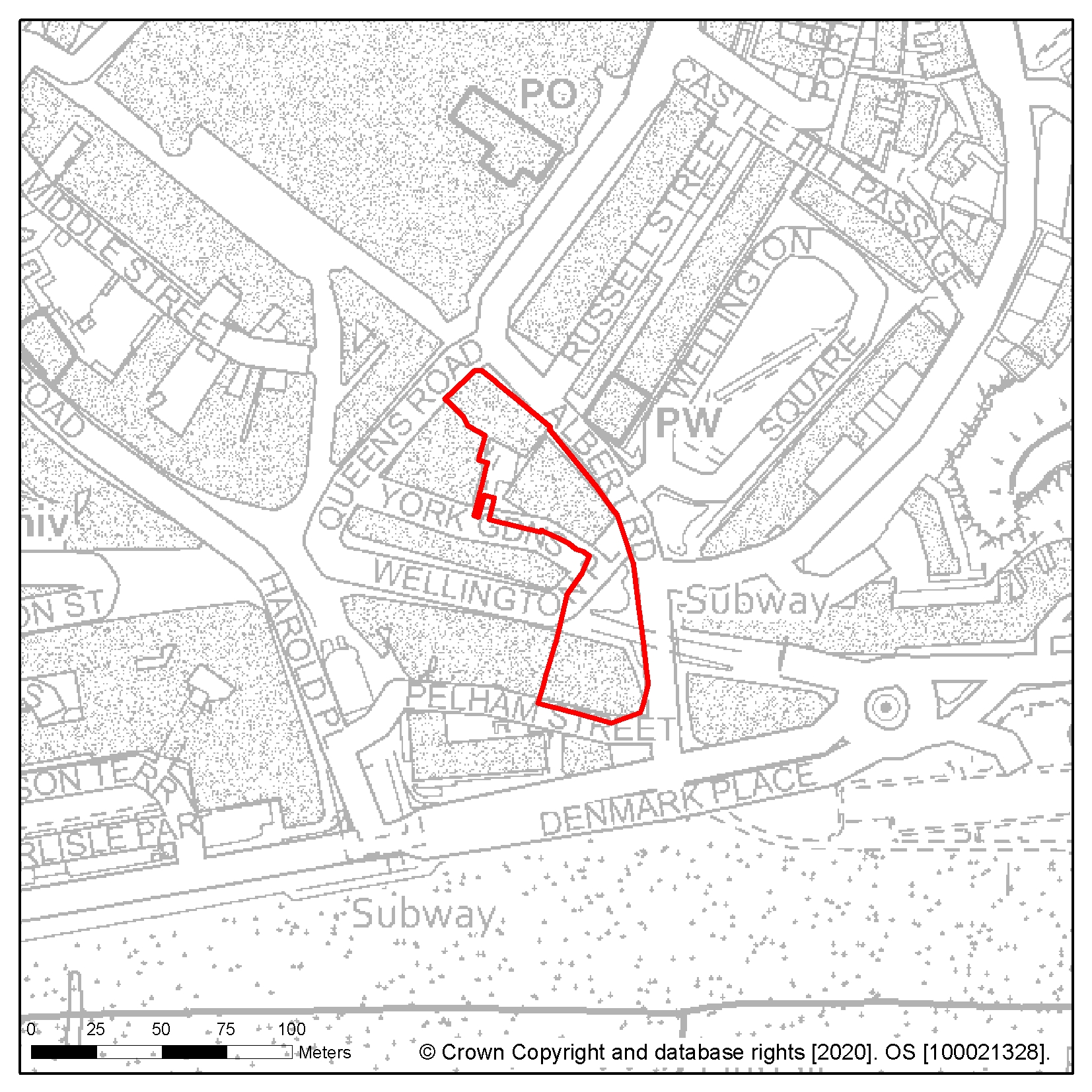
Site reference: TC6
Site name: Former Post Office, Cambridge Road and former University of Brighton building, Priory Quarter
Focus Area/Strategic Policy: Focus Area 1: Hastings Central
Use: Commercial/employment led mixed use. Option to include residential uses
Indicative capacity (net residential dwellings/floorspace): 2,900sqm
Site specific development considerations based on draft Local Plan policies:
Development on this site should:
- Enhance public realm within Priory Square, including policy compliant 'greening' to the site in a form appropriate to the urban setting, seating and improvements to open space to encourage active and positive daytime use and support the promotion of Priory Street as a secondary route to the Town Centre and Bohemia
- Provide for active uses at ground floor level which should include retail, leisure or other town centre complementary uses which also preserve the frontage of the former post office building
- Preserve and enhance the setting of the conservation area and long-range views of and from Hastings Castle
- Take appropriate measures to mitigate the impact of noise on residential dwellings due to location within the active night time economy setting
- Include easements for works and infrastructure access to surrounding premises
- Provide 25% affordable housing where new residential development is built in line with policy SP2
- Secure Priory Square at street level to Priory Street and Havelock Road to support community cohesion
The following image shows a map of the site boundary.
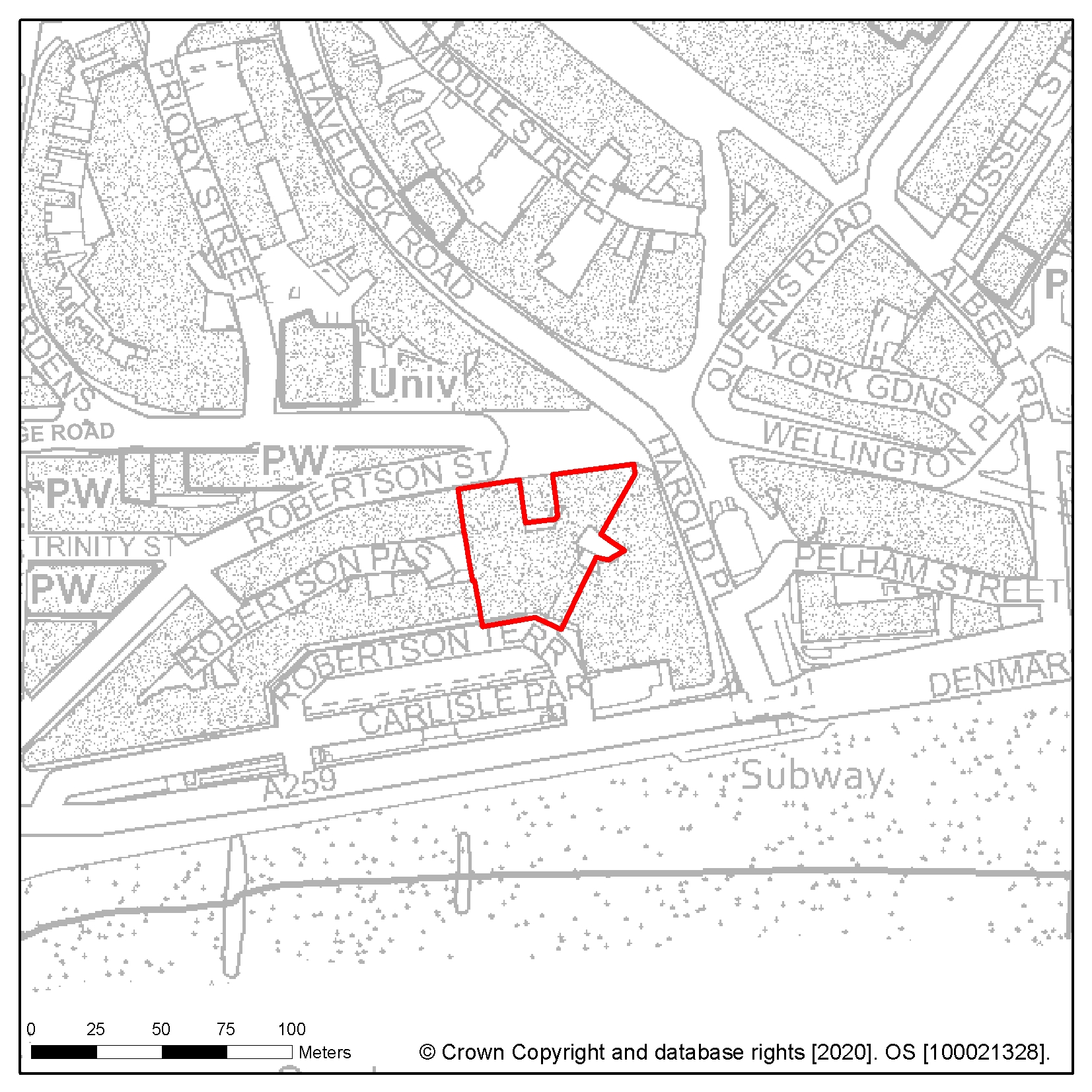
Site reference: TC9 Site name: Harold Place (site of former public conveniences)
Focus Area/Strategic Policy: Focus Area 1: Hastings Central
Use: Commercial/employment led mixed use
Indicative capacity (net residential dwellings/floorspace): 200sqm
Site specific development considerations based on draft Local Plan policies:
Development on this site should:
- Provide a landmark feature at the gateway to and from the seafront
- Provide active uses at ground floor level
- Consider that the site is within a conservation area and nearby to listed assets, and so the impact and proposals on the setting should be in keeping
- Consider that due to former use, it is possible some contamination on site is present in the remainder of the structure below ground level
- Respond to the town square setting at memorial and Harold Place, providing clear routes to the centre and the seafront
- Introduce policy compliant 'greening' to the site in a form appropriate to the urban setting
The following image shows a map of the site boundary.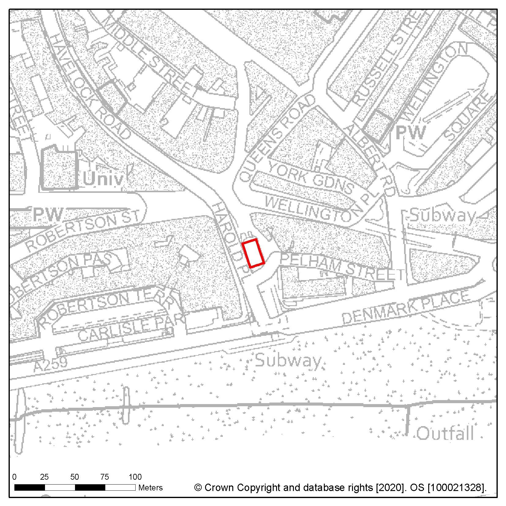
Site reference: TC10 Site name: Cornwallis Street car park
Focus Area/Strategic Policy: Focus Area 1: Hastings Central
Use: Mixed use – Hotel or residential led
Indicative capacity (net residential dwellings/floorspace): 20 (minimum)
Site specific development considerations based on draft Local Plan policies:
Development on this site should:
- Create an active frontage with commercial use at ground floor level
- Include publicly accessible play, 'pocket park' or similar open recreational space with housing development, and policy compliant 'greening' to the site in a form appropriate to the urban setting
- Mitigate the impact of noise on residential dwellings with appropriate measures due to its location within the active night time economy setting
- Relate well to the existing street scene and provide clear movement routes to both the east and west of the site
- Provide 25% affordable housing where new residential development is built in line with policy SP2
The following image shows a map of the site boundary.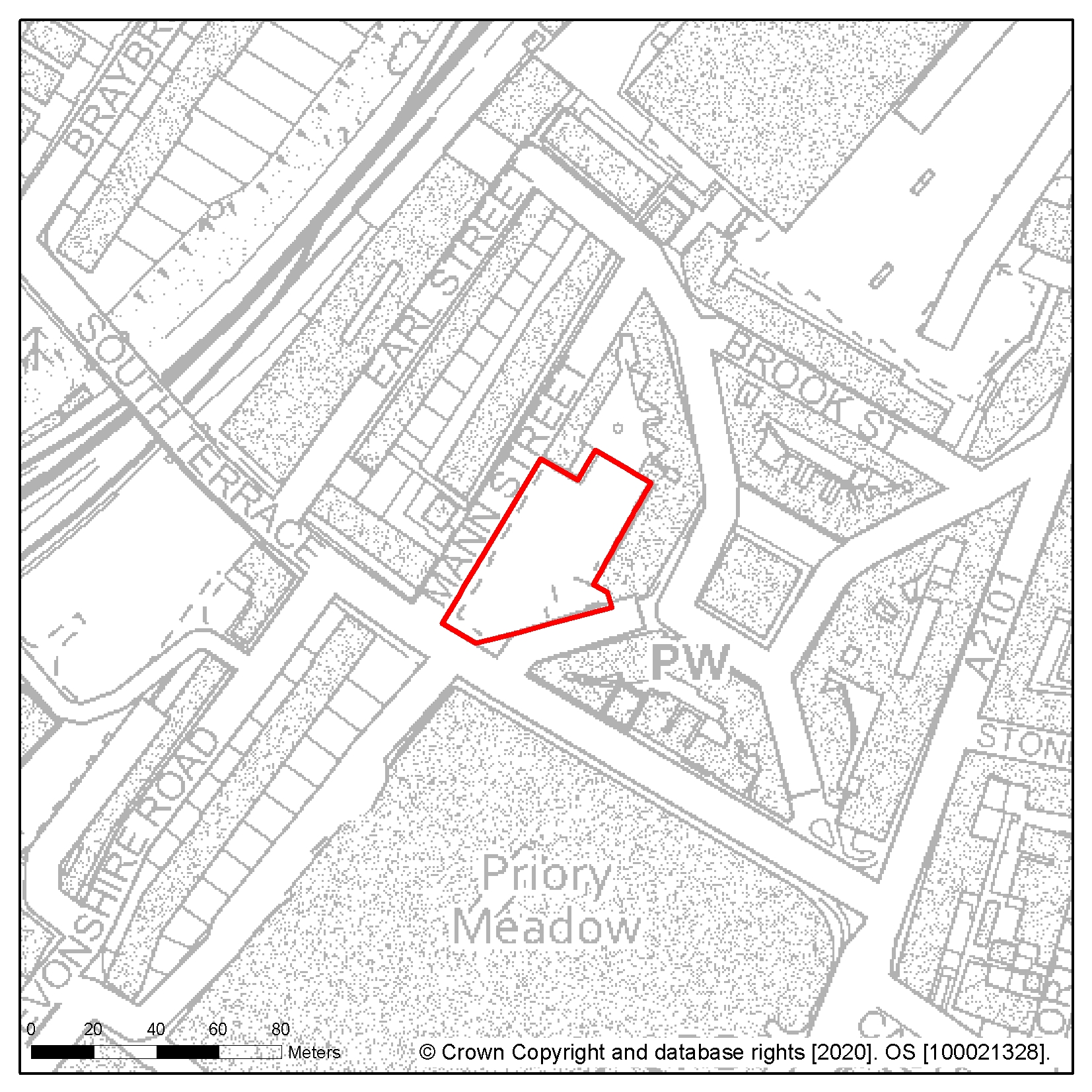
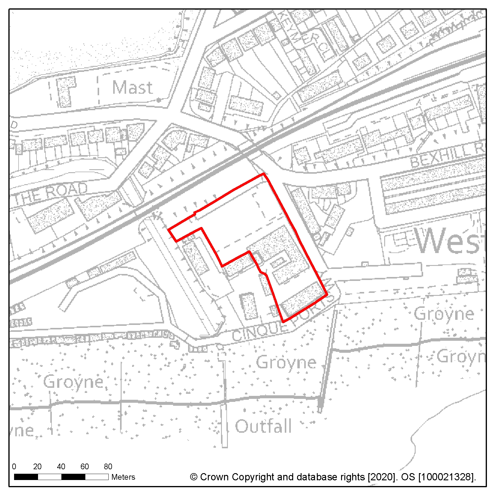
Site reference: TC11 Site name: Muriel Matters House
Focus Area/Strategic Policy: Focus Area 1: Hastings Central
Use: Mixed use – Hotel or residential led
Indicative capacity (net residential dwellings/floorspace): TBC
Site specific development considerations based on draft Local Plan policies:
Development on this site should:
- Preserve and enhance the setting of all heritage assets, and particularly the key townscape views to and from Hastings Castle, as the site sits within the setting of Hastings Castle (Scheduled Monument and Grade I listed), the Pelham Group of Grade II* listed buildings, the Old Town Conservation Area and Hastings Town Centre Conservation Area
- Provide for active uses at ground floor level which should include retail, leisure or other 'town centre' complementary uses
- Include policy compliant 'greening' to the site in a form appropriate to the urban setting
- Include mitigation measures for wind effect. Provide easement to allow access to existing electrical network infrastructure at the rear of the building
- Mitigate the impact of noise on residential dwellings with appropriate measures due to location within the active night-time economy setting
- Avoid or mitigate any impact on the Castle Hill Local Wildlife Site
- Contribute to pedestrian and cycling routes to Hastings Central and the seafront in line with existing schedule of works
The following image shows a map of the site boundary.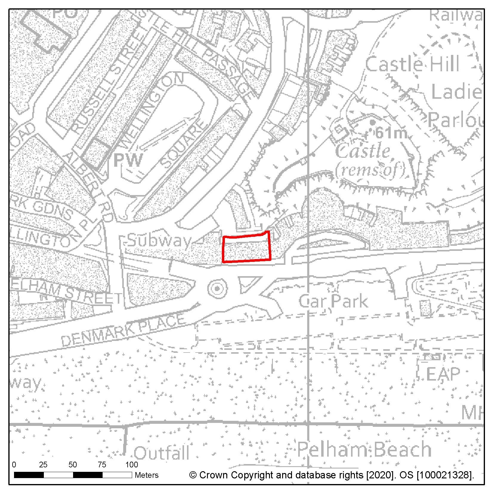
Site reference: HL1 Site name: Holmhurst St Mary
Focus Area/Strategic Policy: Focus Area 3: Little Ridge and Ashdown House
Use: Residential
Indicative capacity (net residential dwellings/floorspace): 258
Site specific development considerations based on draft Local Plan policies:
Development on this site should:
- Provide 40% affordable housing in line with policy SP2
- Demonstrate the transport impact on The Ridge and provide for bus access through the site and adjacent HL2 to relieve congestion on The Ridge subject to Transport Assessment
- Take account of Southern Water's underground infrastructure in the design of the layout of the site. Easements would be required, which may affect the site layout or require diversion and should be clear of all proposed buildings and tree planting
- Provide new publicly accessible open space
- Some of the area to the eastern boundary is categorised as flood zone 2, and should be incorporated into open space
- Consider the impact of proposals on the AONB, incorporating any recommendations arising from a Landscape Assessment
- Preserve and restore the Grade II listed statue of Queen Anne, and adjacent nun's cemetery and the significance of Grade II listed Holmhurst St Mary School
- Minimise the impact on the Holmhurst St Mary Local Wildlife Site and ancient woodland within the site and incorporate appropriate conservation and mitigation measures
The following image shows a map of the site boundary.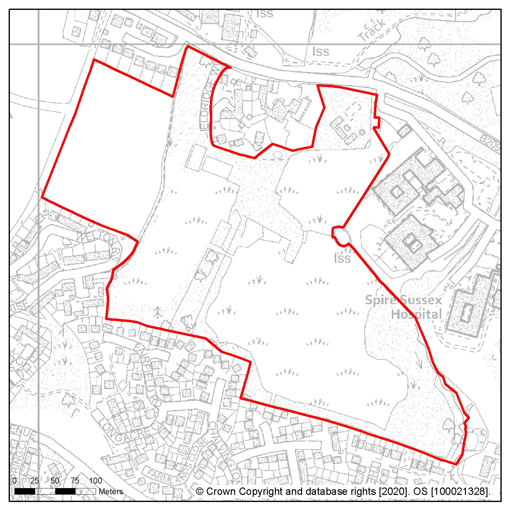
Site reference: HL21 Site name: Horntye
Focus Area/Strategic Policy: Focus Area 2: Bohemia
Use: Residential
Indicative capacity (net residential dwellings/floorspace): 250
Site specific development considerations based on draft Local Plan policies:
Development on this site should:
- Provide 25% affordable housing in line with policy SP2
- Be part of a comprehensive or coordinated development of Bohemia, subject to relocation of sport provision
- Enhance and reveal the significance of the setting of the Grade II listed icehouse, including insulating its earth mound and providing for safe public access
- Expand opportunities for natural play
- Minimise impacts on Summerfield Wood Local Nature Reserve and where appropriate incorporate conservation and mitigation measures
- Incorporate cycle and pedestrian routes to Hastings Town Centre, Summerfields Woods, Amhurst Gardens, the Bohemia and Tower Local Centre, Central St Leonards and the seafront
- Provide an assessment of potential land contamination and any mitigation measures required as this is a historic landfill site
The following image shows a map of the site boundary.
Site reference: HL55 Site name: Summerfields
Focus Area/Strategic Policy: Focus Area 2: Bohemia
Use: Residential led mixed use including community/cultural and smaller scale office/light industrial uses (subject to relocation of the leisure centre)
Indicative capacity (net residential dwellings/floorspace): 250
Site specific development considerations based on draft Local Plan policies:
Development on this site should:
- Provide 25% affordable housing required in line with policy SP2
- Be part of a comprehensive or coordinated development of Bohemia, subject to the relocation of the existing leisure centre
- Create a network of green infrastructure and opportunities to play on site
- Retain mature trees on site and include measures to protect Summerfields Wood Local Nature Reserve
- Relocate existing civic functions
- Incorporate cycle and pedestrian routes to Hastings Town Centre, Summerfields Woods, Amhurst Gardens, the Bohemia and Tower Local Centre, Central St Leonards and the seafront
The following image shows a map of the site boundary.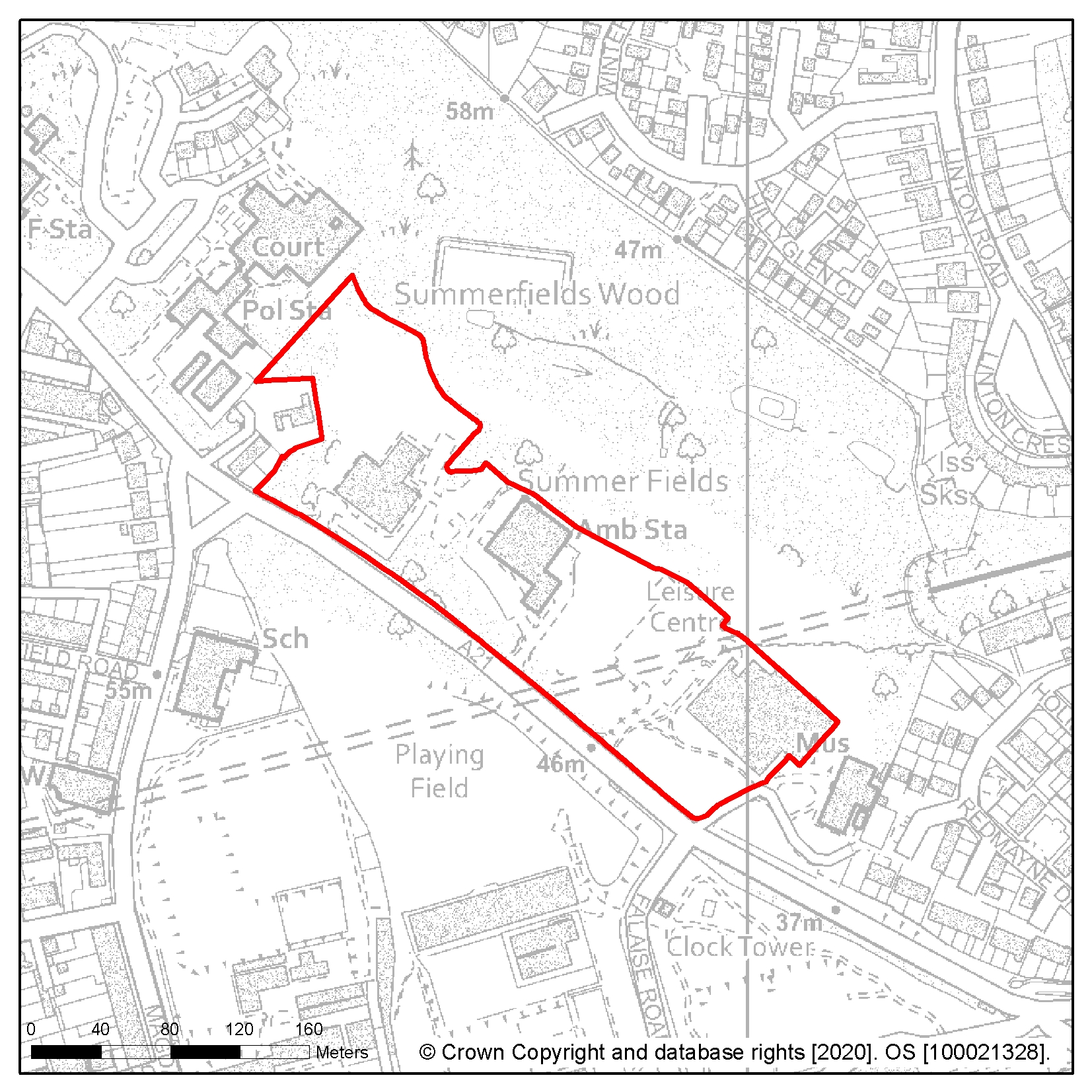
Site reference: HL80 Site name: Ashdown House, Sedlescombe Road North
Focus Area/Strategic Policy: Focus Area 3: Little Ridge and Ashdown House
Use: Residential and local scale community/leisure uses
Indicative capacity (net residential dwellings/floorspace): 246
Site specific development considerations based on draft Local Plan policies:
Development on this site should:
- Provide 25% affordable housing requirement in line with policy SP2
- This site has a high groundwater table, and drainage design should be informed by monitoring
- Take the opportunity to feature highly contemporary design
- Include some local leisure provision on site
- Include policy compliant 'greening' within the site
The following image shows a map of the site boundary.
Site reference: HL2 Site name: Former Harrow Lane playing fields
Focus Area/Strategic Policy: Focus Area 3: Little Ridge and Ashdown House
Use: Residential
Indicative capacity (net residential dwellings/floorspace): 212
Site specific development considerations based on draft Local Plan policies:
Development on this site should:
- Provide 40% affordable housing requirement in line with policy SP2
- Provide for bus access through the site linking to HL1 to relieve congestion on The Ridge subject to a Transport Assessment
- Provide new publicly accessible open space
- Take account of Southern Water's underground infrastructure in the design of the layout of the site. Easements would be required, which may affect the site layout or require diversion, these should be clear of all proposed buildings and tree planting
The following image shows a map of the site boundary.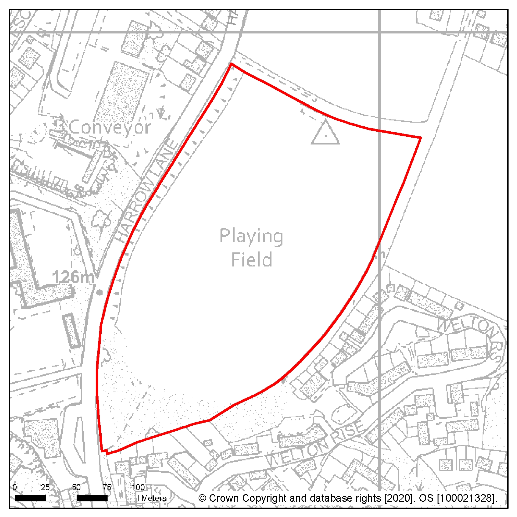
Site reference: HL7
Site name: Former St Leonards Academy (Grove School), Darwell Campus, Darwell Close
Focus Area/Strategic Policy: n/a
Use: Residential
Indicative capacity (net residential dwellings/floorspace): 210
Site specific development considerations based on draft Local Plan policies:
Development on this site should:
- Provide 25% affordable housing in line with policy SP2
- Introduce a clear road hierarchy and potentially include a loop-route for primary access and servicing, secondary access connecting streets in light red, and shared-surface streets for the edges of the site
- Improve local connectivity with walking and cycling links to improve and to preserve the Public Right of Way at the north of the site and to enhance access to Dog Kennel Wood and Combe Valley Countryside Park
- Minimise impact on the adjacent Wishing Tree, Filsham Golf Course Local Wildlife Sites and ancient woodland and incorporate appropriate conservation and mitigation measures
- Include publicly accessible open space, with the main route through the site oriented so that at all points it has a view towards the main open space and/or the site entrances (vehicular or pedestrian). This will support wayfinding and orientation through the site
- Take account of Southern Water's underground infrastructure that crosses the site in the design of the layout of the site. Easements would be required, which may affect the site layout or require diversion, and these should be clear of all proposed buildings and tree planting
- Ensure future access to the existing sewerage infrastructure for maintenance and upsizing purposes as advised by Southern Water
The following image shows a map of the site boundary.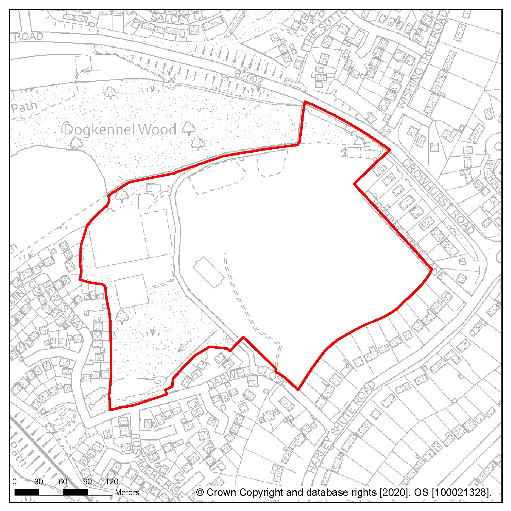
Site reference: HL112
Site name: Land at corner of St Helens Down and playing fields of former Helenswood School
Focus Area/Strategic Policy: n/a
Use: Residential
Indicative capacity (net residential dwellings/floorspace): 113
Site specific development considerations based on draft Local Plan policies:
Development on this site should:
- Provide 40% affordable housing requirement in line with policy SP2
- Take account of Southern Water's underground infrastructure in the design of the layout of the site. Easements would be required, which may affect the site layout or require diversion, and these should be clear of all proposed buildings and tree planting
- Maintain and improve boundary landscaping between the site and the flagship school to the north
- Consider that development may have an impact on flood risk downstream from all sources of flooding
The following image shows a map of the site boundary.
Site reference: HL19 Site name: Land adjacent to Sandrock Park, The Ridge
Focus Area/Strategic Policy: n/a
Use: Residential
Indicative capacity (net residential dwellings/floorspace): 140
Site specific development considerations based on draft Local Plan policies:
Development on this site should:
- Provide 25% affordable housing requirement in line with policy SP2
- Take account of Southern Water's underground infrastructure in the design of the layout of the site. Easements would be required, which may affect the site layout or require diversion, and these should be clear of all proposed buildings and tree planting
- Take into account the impact of development on the Grade II listed lodge.
- Avoid or mitigate any impact on the adjacent woodland and St Helens Wood Local Wildlife Site and Local Nature Reserve
The following image shows a map of the site boundary.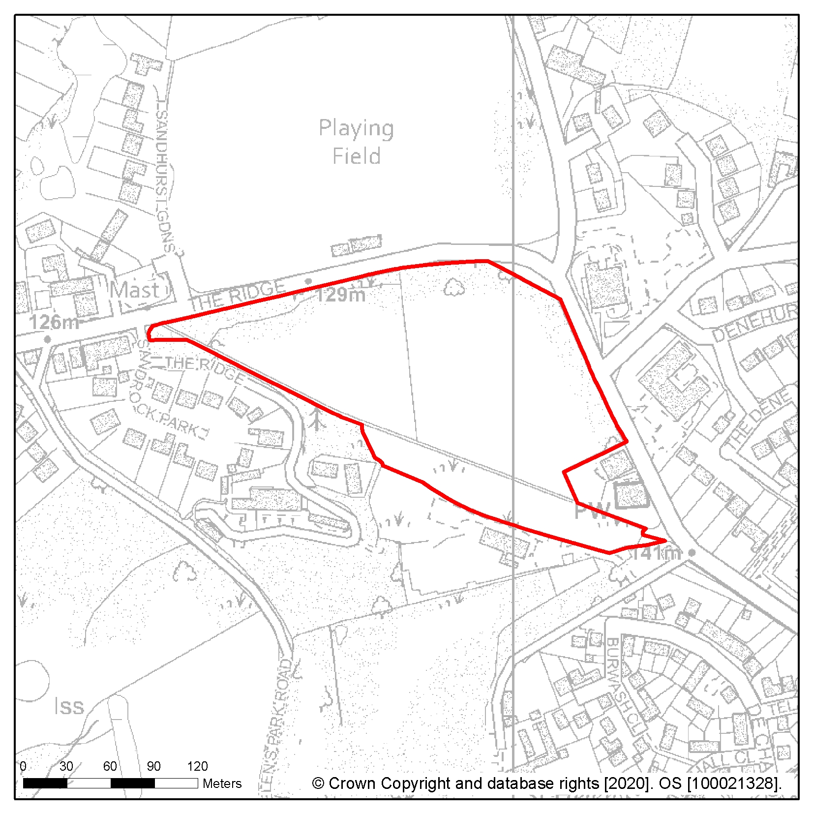
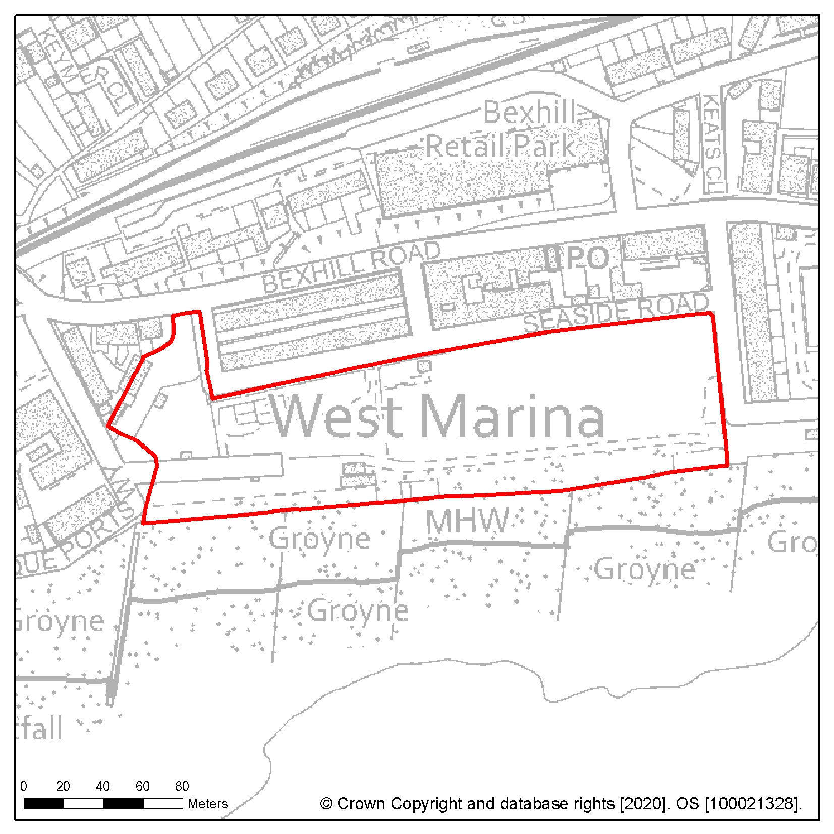
Site reference: HL9 Site name: Seaside Road, West St Leonards
Focus Area/Strategic Policy: Focus Area 4: West Marina and West St Leonards
Use: Residential led mixed use scheme to include commercial, leisure and retail uses to attract residents from the wider area and visitors. Beach huts and play equipment should be retained or relocated.
Indicative capacity (net residential dwellings/floorspace): 152
Site specific development considerations based on draft Local Plan policies:
Development on this site should:
- Provide 25% affordable housing in line with policy SP2
- Explore opportunities for co-ordinating development with the Cinque Ports Way site (HL11), or allowances made to better enable this including any road and junction improvements.
- Strengthen link to West St Leonards Station and the cycle route and public right of way at the south of the site should be preserved and the existing cycle path enhanced
- Respond to underground constraints with the possibility of an informal residential layout to the west of this site with more formal residential development in the east relating to the form and scale of the Grosvenor Gardens Conservation Area
- Provide a public realm and promenade that is attractive and inviting to residents and tourists that should also act as a way of protecting views along the seafront. Pedestrian access to the beach should be enhanced, particularly to the west of the site near the existing access at Cinque Ports Way
- Provide new public open space land above the underground tank in the north of the site with informal opportunities for 'play' integrated into the design of the site
- Incorporate measures to address flood risk. This should include improvements to the sea wall and contributions to ongoing maintenance in light of tidal and fluvial flood risk (Zone 3). This site has a high groundwater table and drainage design should be informed by onsite monitoring
- Incorporate a creative design response to integrating the electricity substation
- Provide a connection to the sewerage system at the nearest point of adequate capacity, as advised by Southern Water and ensure future access to the existing sewerage and water supply infrastructure for maintenance and upsizing purposes. It should also take account of Southern Water's underground infrastructure in the design of the layout of the site. Easements would be required, which may affect the site layout or require diversion, and these should be clear of all proposed buildings and tree planting
- Provide an assessment of ground conditions and potential contamination and any necessary mitigation measures
The following image shows a map of the site boundary.
Site reference: HL84 Site name: Pilot Field, Elphinstone Road
Focus Area/Strategic Policy: n/a
Use: Residential
Indicative capacity (net residential dwellings/floorspace): 120
Site specific development considerations based on draft Local Plan policies:
Development on this site should:
- Provide 25% affordable housing in line with policy SP2
- Take account of Southern Water's underground infrastructure in the design of the layout of the site. Easements would be required, which may affect the site layout or require diversion, and these should be clear of all proposed buildings and tree planting
- Protect and enhance the Ochiltree Woods Local Wildlife Site situated within this site to the north and east, minimising and mitigating against any adverse impacts.
- Take into account that this site has a high groundwater table and drainage design should be informed by onsite monitoring
- Reprovision the existing use of the site
- Provide an assessment of potential land contamination and any mitigation measures required as part of the site was landfill in the past
The following image shows a map of the site boundary.
Site reference: HL12 Site name: Former Malmesbury House, West Hill Road
Focus Area/Strategic Policy: Focus Area 4: West Marina and West St Leonards
Use: Residential
Indicative capacity (net residential dwellings/floorspace): 117
Site specific development considerations based on draft Local Plan policies:
Development on this site should:
- Provide 25% affordable housing in line with policy SP2
- Consider that the site occupies an elevated prominent location at the western end of the conservation area and is visible from a distance, particularly from the direction of the seafront. Any development must therefore respect longer distance views of the site as well as its immediate surroundings, enhancing the significance and setting of the Grosvenor Gardens Conservation Area
- Investigate the impact of land stability and incorporate mitigation measures as appropriate
- Avoid or mitigate against any adverse impacts on Caves Road Cliffs Local Wildlife Site
- Provide a connection to the sewerage system at the nearest point of adequate capacity, as advised by Southern Water and ensure future access to the existing sewerage and water supply infrastructure for maintenance and upsizing purposes
- Take account of Southern Water's underground infrastructure in the design of the layout of the site. Easements would be required, which may affect the site layout or require diversion, and these should be clear of all proposed buildings and tree planting
The following image shows a map of the site boundary.
Site reference: HL113 Site name: Former Westerleigh School playing fields
Focus Area/Strategic Policy: n/a
Use: Residential
Indicative capacity (net residential dwellings/floorspace): 108
Site specific development considerations based on draft Local Plan policies:
Development on this site should:
- Provide 25% affordable housing in line with policy SP2
- Provide an Arboriculture Plan that demonstrates how existing trees on site will be integrated into the development, or how compensation will be made for their loss
- Take account of Southern Water's underground infrastructure in the design of the layout of the site. Easements would be required, which may affect the site layout or require diversion, and these should be clear of all proposed buildings and tree planting
- Have discharge rates agreed with the Pevensey & Cuckmere Water Level Management Board (PCWLMB) prior to granting of permission
The following image shows a map of the site boundary.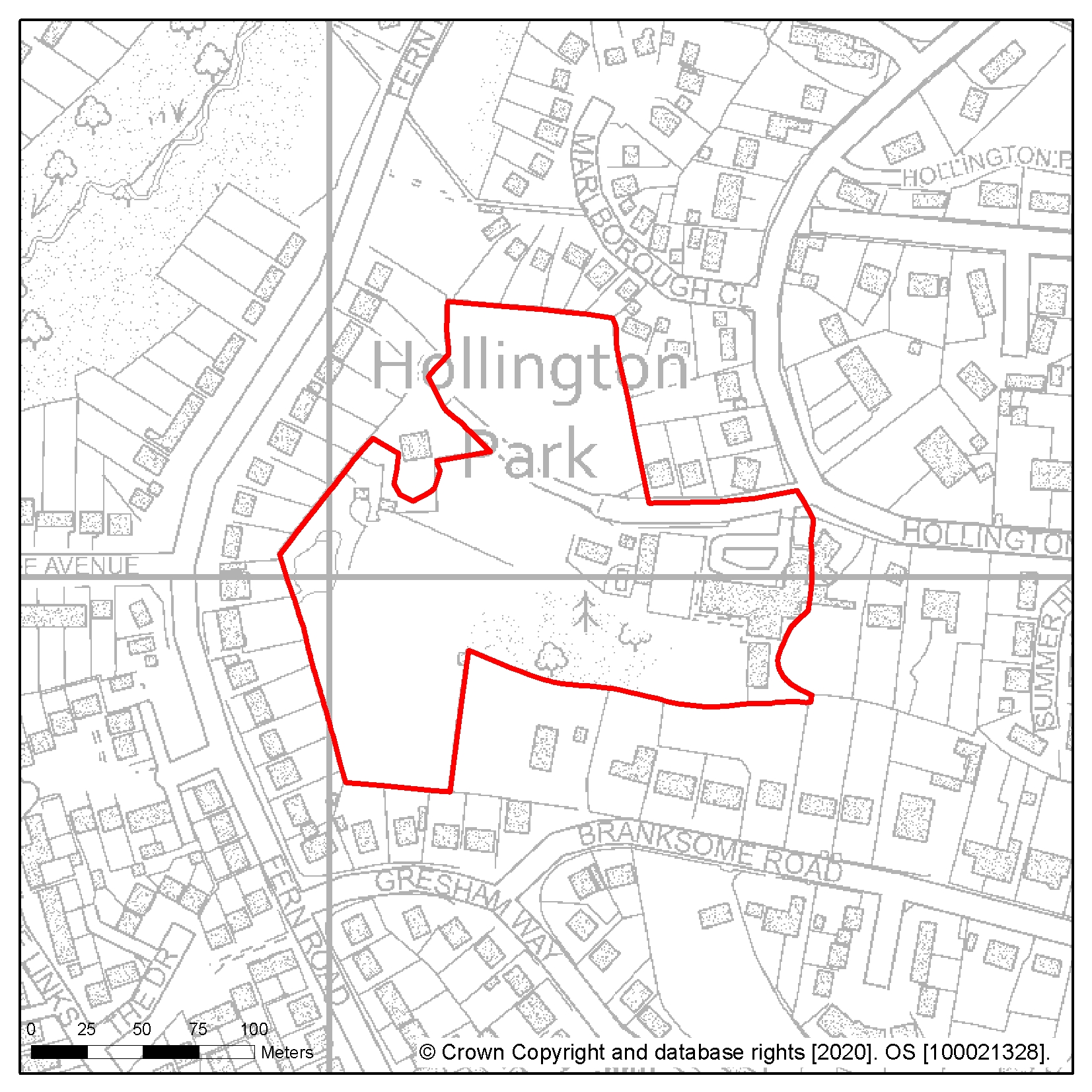
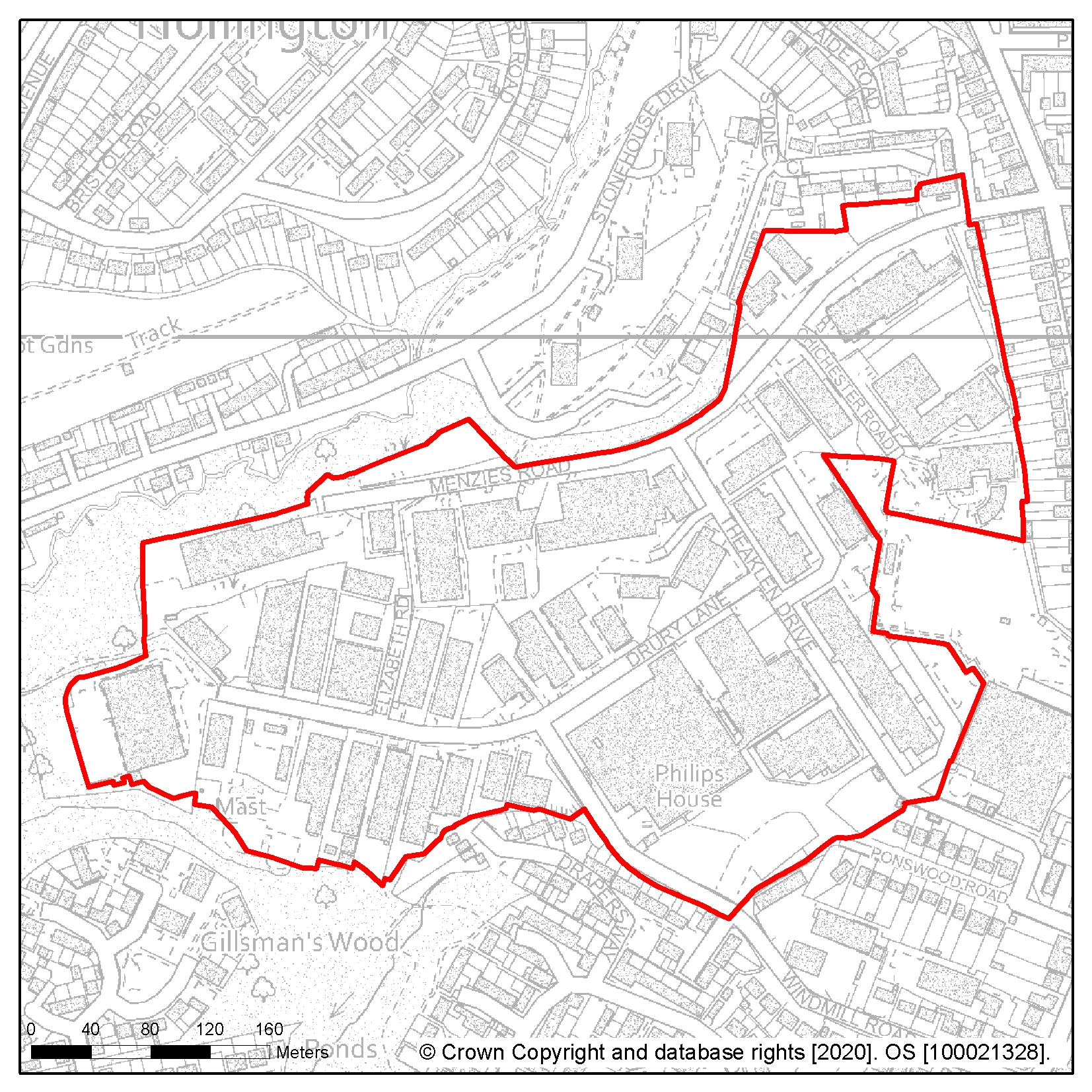
Site reference: HL35 Site name: Hastings Station Yard (part)
Focus Area/Strategic Policy: Focus Area 1: Hastings Central
Use: Residential
Indicative capacity (net residential dwellings/floorspace): minimum 101
Site specific development considerations based on draft Local Plan policies:
Development on this site should:
- Support placemaking at key point of 'gateway' into town, with associated scope to change perceptions, higher density, taller development is appropriate in this highly accessible location
- Avoid adverse impact on the amenity of adjoining residents, particularly those in Devonshire Road and South Terrace
- Create new multifunctional private amenity spaces within the site, this may be at multiple elevations together with policy compliant 'greening' in a form appropriate to the urban setting
- Improve access routes to existing open spaces at Alexandra Park, Summerfields Woods, Cornwallis and Linton Gardens and Hastings beach
- Enhance walking and cycling connectivity to the surrounding area particularly to the main transport terminus, town centre, seafront and parks and gardens including the proposed strategic cycle network to the north of the site to include the safeguarding of an adequate width of land to enable the implementation of the strategic network of cycle routes and contribute to its creation and management as appropriate
- Take account of Southern Water's underground infrastructure in the design of the layout of the site. Easements would be required, which may affect the site layout or require diversion, and these should be clear of all proposed buildings and tree planting
The following image shows a map of the site boundary.
Site reference: HL3 Site name: Land adjacent to 777 The Ridge
Focus Area/Strategic Policy: Focus Area 3: Little Ridge and Ashdown House
Use: Residential
Indicative capacity (net residential dwellings/floorspace): 98
Site specific development considerations based on draft Local Plan policies:
Development on this site should:
- Provide 40% affordable housing in line with policy SP2
- Be sensitive in design of the site setting particularly in regard to the scale and form of development. This includes taking account of the Area of Outstanding Natural Beauty (AONB) that lies on the opposite side of The Ridge and the long views to the north into and out of it so as to minimise the visual impact of development on the AONB. Measures to conserve and enhance the AONB should be included
- Include a Historic Environment Record (HER) informed desk based assessment of potential interest within an archaeological notification area and agree to a 'watching brief' during any development works (as advised by East Sussex County Council)
- Demonstrate consideration of the transport impact along The Ridge and include improved access from Harrow Lane. Proposals should also include an assessment of site suitability for alternative mobility solutions, such as car clubs, and show how they have been incorporated into the development. This should be considered in collaboration with adjacent schemes at Holmhurst St Mary (HL1) and Harrow Lane playing fields (HL2)
- Consider improvements to walking and cycling connectivity and permeability in conjunction with the adjacent sites and preserve and enhance the public right of way around the site
- Contribute to the green infrastructure network including improved connections between the open and green spaces to support their ecological and recreational value. This should include the provision of new publicly accessible green space within the site and the reinforcement of the pedestrian route to the bridleway. Boundary landscaping should also be included to act as a buffer to surrounding development
The following image shows a map of the site boundary.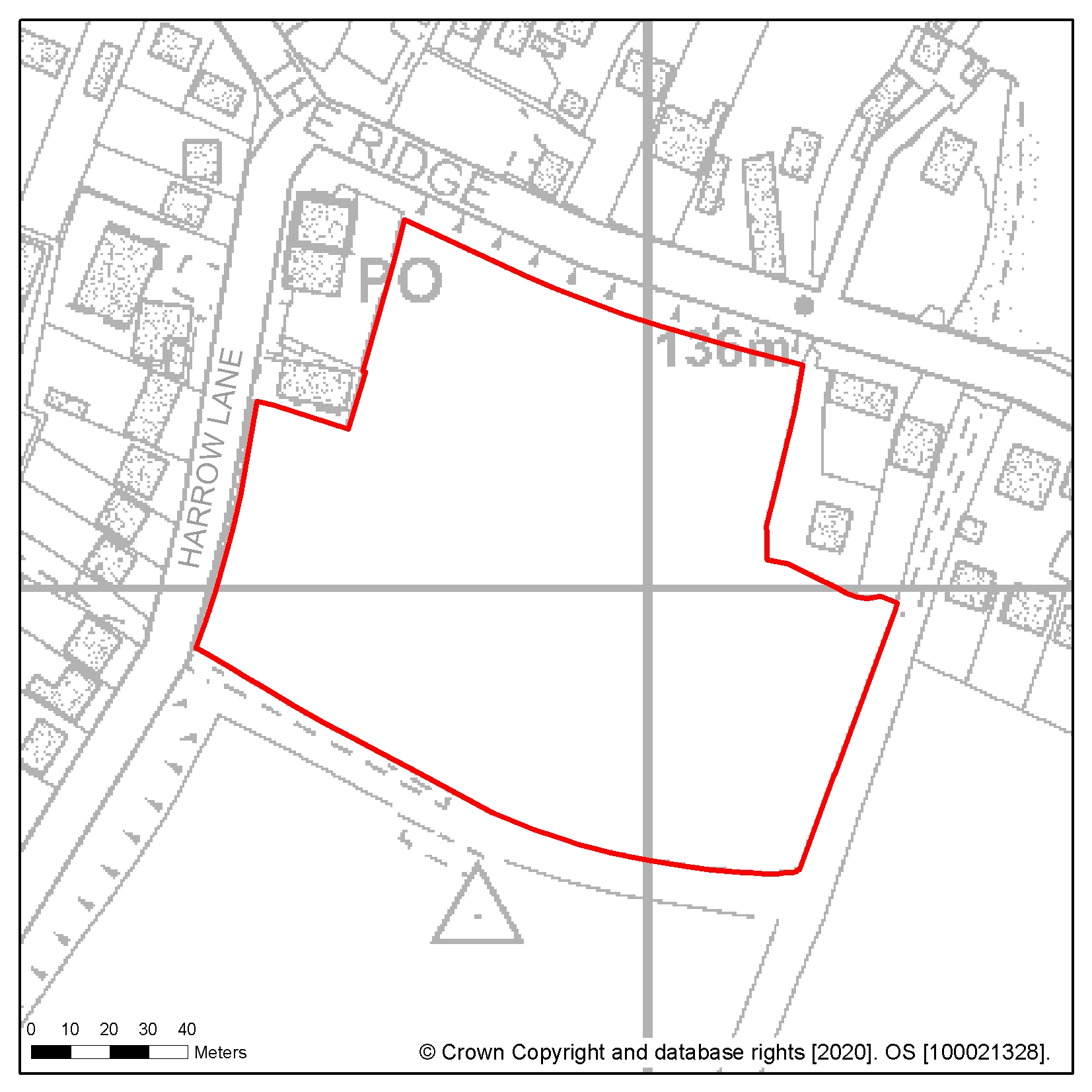
Site reference: HL115 Site name: Former West St Leonards Primary School, Bexhill Road
Focus Area/Strategic Policy: Focus Area 4: West Marina and West St Leonards
Use: Residential
Indicative capacity (net residential dwellings/floorspace): 60
Site specific development considerations based on draft Local Plan policies:
Development on this site should:
- Provide 25% affordable housing in line with policy SP2
- Provide all vehicular access from Filsham Road
- Provide new formal publicly accessible open space within the site suitable for a variety of uses taking into account its location within an area of current and projected deficiencies in access to certain types of open space
- Achieve high standards of sustainable design and construction
- Protect and safeguard the adjacent South Saxons Local Wildlife Site to the west and north and avoid or mitigate against any adverse impacts
- Provide an assessment of potential land contamination and any mitigation measures required. Part of the site was formerly a refuse tip and may still produce landfill gas. There is also a small area of contaminated land in the north-western corner of the site
- Include pedestrian/cycle links that are proposed to the west and south and routes to improve local connectivity and to preserve the public right of way access to South Saxons SNCI at the north west of the site
- Include flood protection and mitigation measures given the area of tidal and fluvial flood risk (Zone 3) on the site.
- Have discharge rates agreed with the Pevensey & Cuckmere Water Level Management Board (PCWLMB) prior to granting of permission. This site also has a high groundwater table and drainage design should be informed by onsite monitoring
- Maintain a buffer zone on either side of the Hollington Stream. The stream is an important ecological asset and is engineered to avoid unacceptable flood risk, so close working with the Council and the Environment Agency is encouraged and opportunities to create a feature of the stream should be explored
- Take account of Southern Water's underground infrastructure in the design of the layout of the site. Easements would be required, which may affect the site layout or require diversion, and these should be clear of all proposed buildings and tree planting
The following image shows a map of the site boundary.

Site reference: HL40 Site name: Former Mount Pleasant Hospital, Frederick Road
Focus Area/Strategic Policy: n/a
Use: Residential
Indicative capacity (net residential dwellings/floorspace): 56
Site specific development considerations based on draft Local Plan policies:
Development on this site should:
- Provide 25 % affordable housing in line with policy SP2
- Make best use of the existing road entrance and the design of development along the spine road that runs north- east to south-west along the centre of the site. The position of the spine road together with the narrowness of the site suggests that housing development is likely to take the form of frontage development on either side of the road. There may also be alternative approaches that might be acceptable, including more depth of development in the south-eastern part of the site
- Safeguard land to enable the implementation of the strategic network of cycle routes and contribute to its creation and management as appropriate
- Protect the large drainage storage tank to the west of the turning head as part of future redevelopment
- Provide a connection to the sewerage system at the nearest point of adequate capacity and/or make improvements to the infrastructure if necessary, as advised by Southern Water
- Take account of Southern Water's underground infrastructure in the design of the layout of the site. Easements would be required, which may affect the site layout or require diversion, and these should be clear of all proposed buildings and tree planting
- Include an updated Management Plan for the identified Ecology Zone, including measures for the management and ongoing maintenance of that area
The following image shows a map of the site boundary.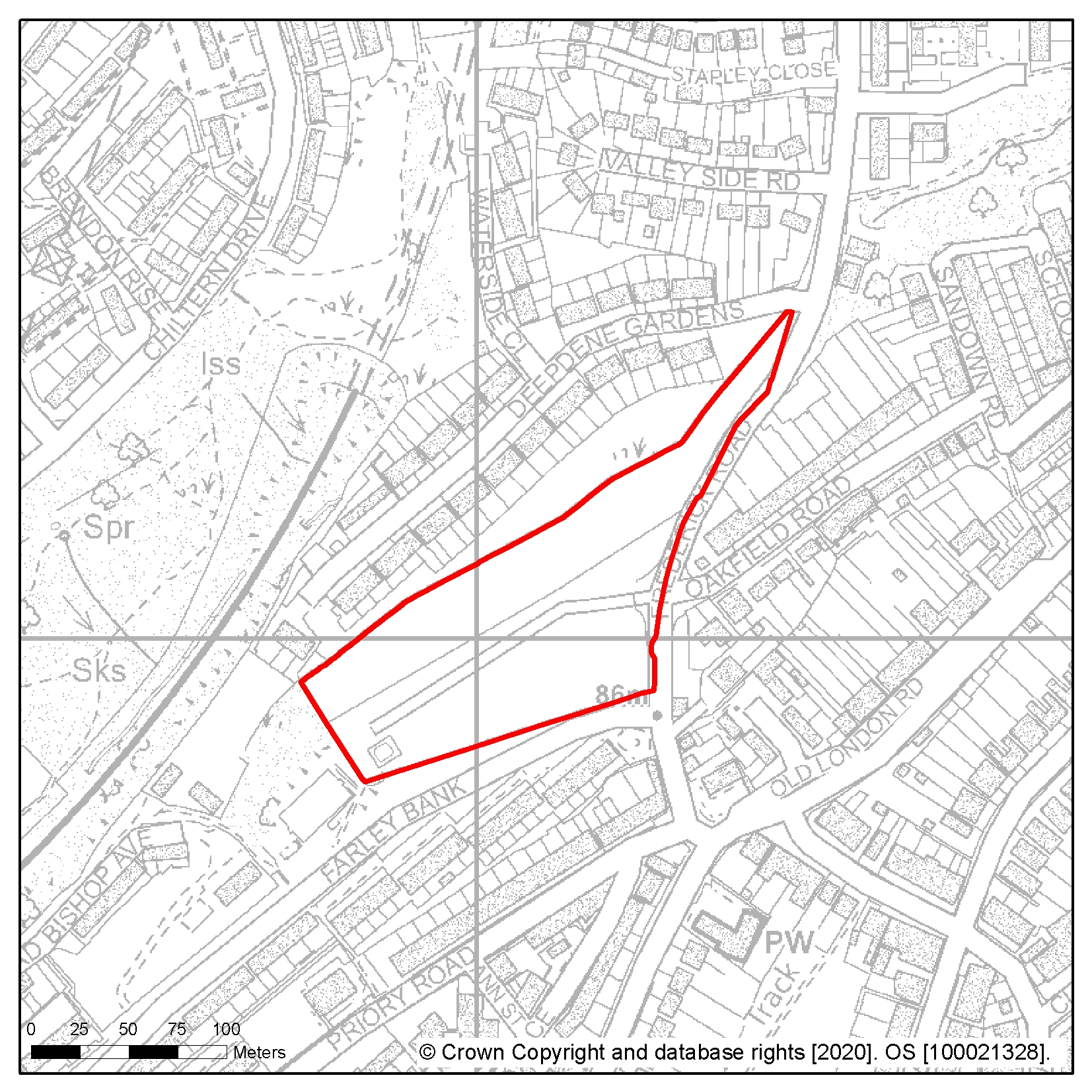
Site reference: HL39 Site name: Ore Valley (Former Power Station)
Focus Area/Strategic Policy: n/a
Use: Residential
Indicative capacity (net residential dwellings/floorspace): 75
Site specific development considerations based on draft Local Plan policies:
Development on this site should:
- Provide 25% affordable housing in line with policy SP2
- Reserve six plots for association self-build and/or custom housebuilding
- In all cases retain the woodland area to the north of the site corresponding to approximately 0.85 ha (capacity has been calculated net of this site area)
- Provide some physical breaks in frontage, with a landscaped area, possibly with a through-route for servicing and emergency access only. Achieving this requires, at least in part, some different housing typologies such as maisonette and/or flatted units to allow more generous plot widths and support four or even five-storey development, corresponding to the scale of development at Priory Road on the opposite hillside, whilst better integrating its sloped woodland setting
- Provide an assessment of potential contamination and any mitigation measures required
- Include pedestrian/cycle links to nearby open spaces, amenities, bus routes and Ore Station
- Consider that this site has a high groundwater table and drainage design should be informed by onsite monitoring
- Protect and safeguard the adjacent Broomgrove Local Wildlife Site to the south and avoid or mitigate against any adverse impacts.
The following image shows a map of the site boundary.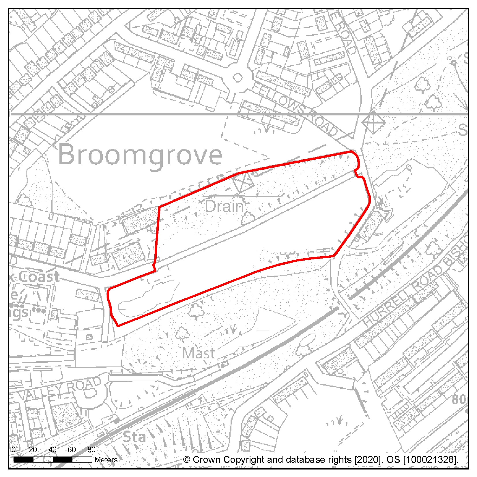
Site reference: HL4 Site name: Mayfield E, Bodiam Drive
Focus Area/Strategic Policy: n/a
Use: Residential
Indicative capacity (net residential dwellings/floorspace): 38
Site specific development considerations based on draft Local Plan policies:
Development on this site should:
- Provide 40% affordable housing in line with policy SP2
- Include walking and cycling links to improve local connectivity
- Sustain and enhance the significance and setting of the Grade II listed Mayfield Farmhouse that is sited immediately to the south west of the site
- Provide boundary landscaping and noise screening along the western border of the site to act as a buffer from Queensway
- Take account of Southern Water's underground infrastructure in the design of the layout of the site. Easements would be required, which may affect the site layout or require diversion, and these should be clear of all proposed buildings and tree planting
The following image shows a map of the site boundary.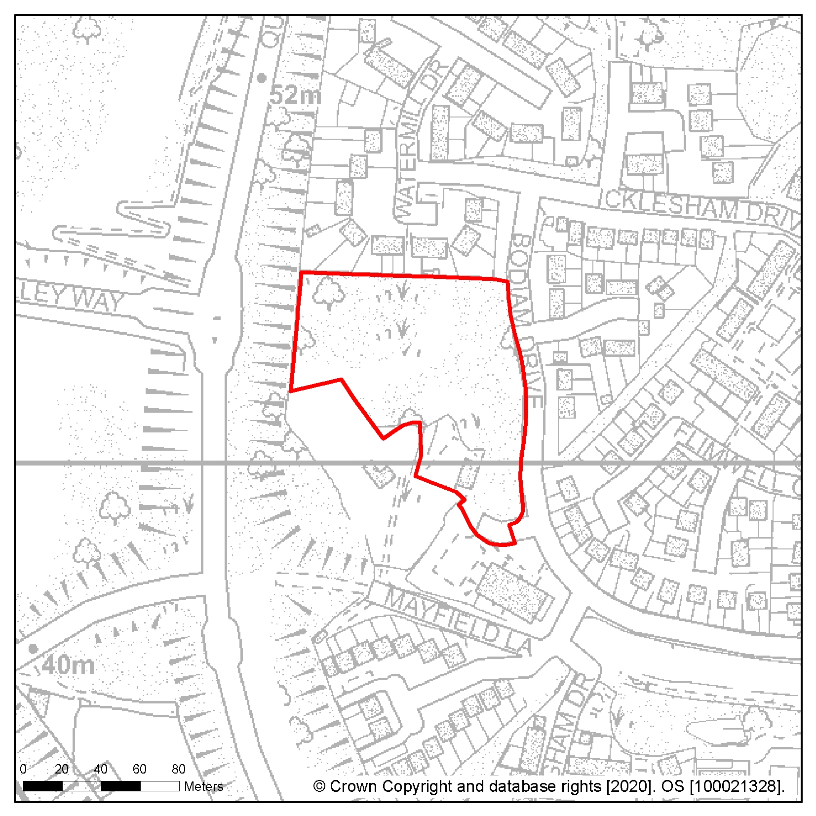
Site reference: HL14 Site name: 190 Bexhill Road
Focus Area/Strategic Policy: n/a
Use: Residential
Indicative capacity (net residential dwellings/floorspace): 32
Site specific development considerations based on draft Local Plan policies:
Development on this site should:
- Provide 25% affordable housing in line with policy SP2
- Demonstrate that it does not threaten the land stability of the adjacent cliff, and include cliff fall mitigation measures where appropriate, such as catch nets
- Take account of Southern Water's underground infrastructure in the design of the layout of the site. Easements would be required, which may affect the site layout or require diversion, and these should be clear of all proposed buildings and tree planting
The following image shows a map of the site boundary.
Site reference: HL33 Site name: Taxi office and former social club, St Johns Road
Focus Area/Strategic Policy: n/a
Use: Residential led mixed use scheme to include commercial uses at street level to complement the function of the St Leonards District Centre
Indicative capacity (net residential dwellings/floorspace): 30
Site specific development considerations based on draft Local Plan policies:
Development on this site should:
- Provide 25% affordable housing in line with policy SP2
- Provide uses that support the function of a town centre and encourage a vibrant active street level frontage to the station forecourt and St Johns Road
- Provide high quality design that sustains and enhances the Kings Road Conservation Area, complements the existing urban form, and enhances the architectural value of the existing buildings
- Consider the relationship with the existing buildings along St Johns Road, including avoiding adverse impacts on amenity such as privacy and overlooking. The relationship with the attractive station buildings to the west is also important
- Ensure that there is no vehicular access from the station forecourt, vehicular access will need to be from St Johns Road
- Demonstrate that it does not threaten the land stability of the railway embankment and tunnel
- Investigate and mitigate any potential impacts of land contamination
- Consider that this site has a high groundwater table and drainage design should be informed by onsite monitoring
The following image shows a map of the site boundary.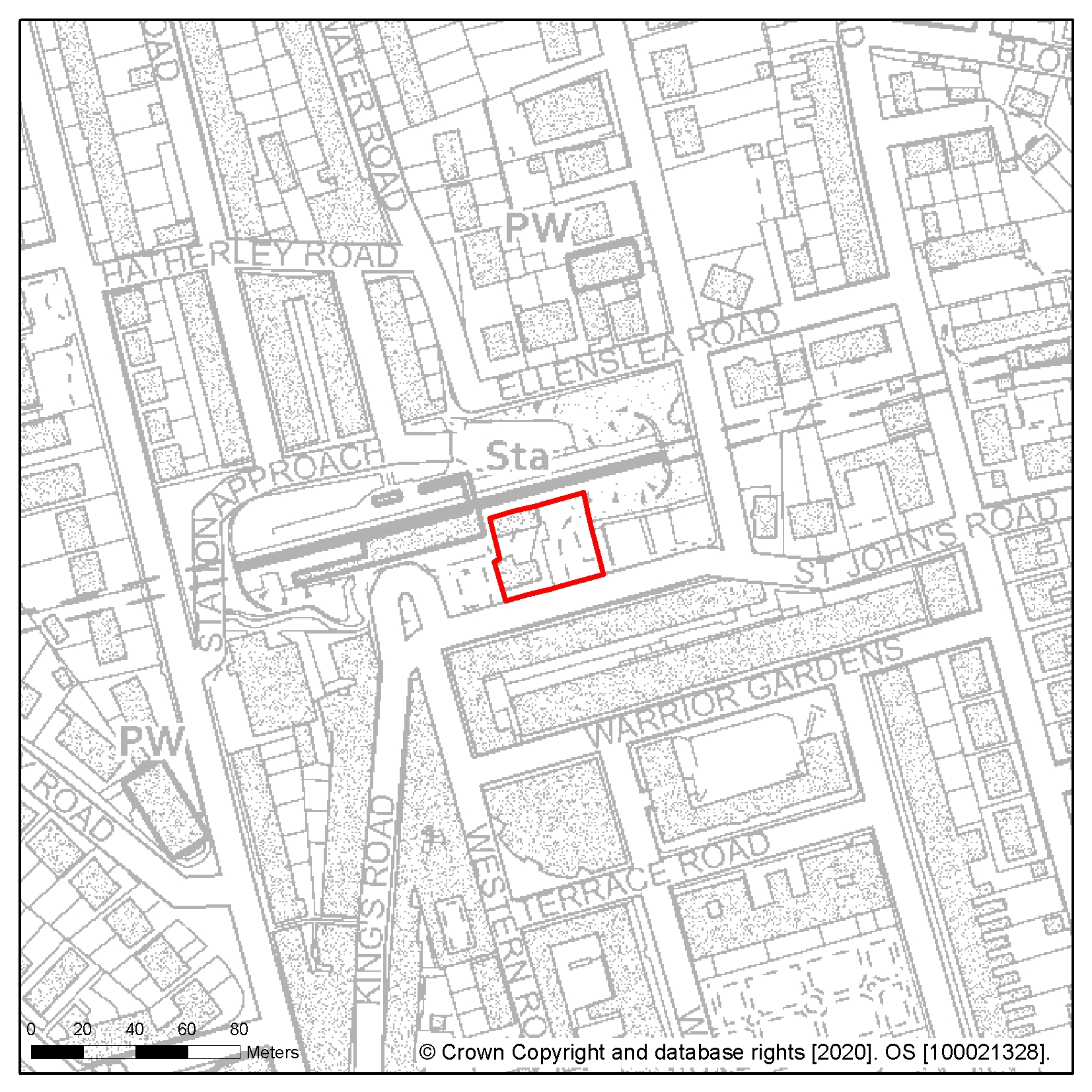
Site reference: HL22 Site name: Former Hollingsworth Garage, Braybrooke Road
Focus Area/Strategic Policy: Focus Area 1: Hastings Central
Use: Residential
Indicative capacity (net residential dwellings/floorspace): 20
Site specific development considerations based on draft Local Plan policies:
Development on this site should:
- Provide 25% affordable housing in line with policy SP2
- Have regard to the impact on both the local street scene and wider views including the protection of important views of Hastings Castle, including existing far-reaching views from the footpath linking Priory Close to Braybrooke Road
- Sustain and enhance the setting of the Blacklands Conservation Area and Alexandra Park to the north and provide innovative solutions for access and any necessary on-site parking taking account of the shape and topography of the site
- Respond to the descending topography of Braybrooke Road, with the built form separated by green corridors to retain the special characteristics of the local area
- Retain and protect the tree belt between the site and the railway line
- Investigate and mitigate any potential impacts of land contamination
- Strengthen pedestrian and cycling links to the surrounding area, in particular access to existing footpaths to Waterworks Road and Alexandra Park
- Form a sensitive mix of typologies from private outdoor space, in order to maximise views of the surrounding area
The following image shows a map of the site boundary.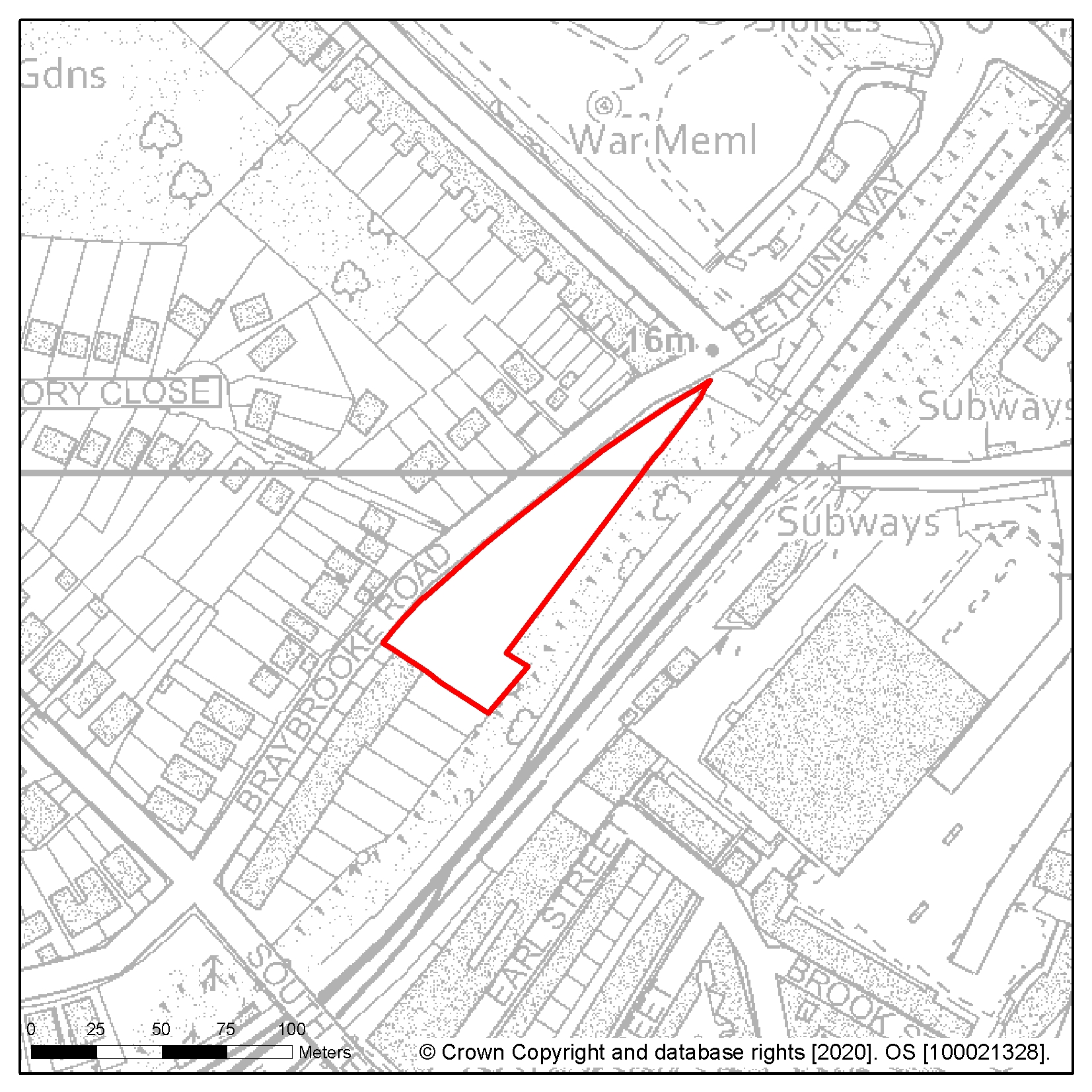
Site reference: HL63 Site name: Land at Rock Lane
Focus Area/Strategic Policy: n/a
Use: Residential
Indicative capacity (net residential dwellings/floorspace): 27
Site specific development considerations based on draft Local Plan policies:
Development on this site should:
- Provide 40% affordable housing in line with policy SP2
- Include a necessary buffer at the eastern boundary of the site (adjacent Rock Lane) due to presence of overhead power lines
- Be in keeping with any relevant policies from Rother District Council development plan documents alongside the Borough boundary
- Relate well to the frontage along Rock Lane and demonstrate the conservation and enhancement of the Area of Outstanding Natural Beauty showing how adverse impacts will be avoided
- Maintain a 5m buffer to the existing drain along the northern boundary of the site
- Provide multi-functional open and play space (or a contribution offsite)
- Strengthen pedestrian and cycling links to the wider AONB and Ivyhouse Lane employment area by providing access to the footpath adjacent the Northern boundary and to Ore village through good quality walking and cycling routes
- Consider that this site has a high groundwater table and drainage design should be informed by onsite monitoring
- Include a Management Plan for the identified Ecology Zone, including measures for the management and ongoing maintenance of that area
The following image shows a map of the site boundary.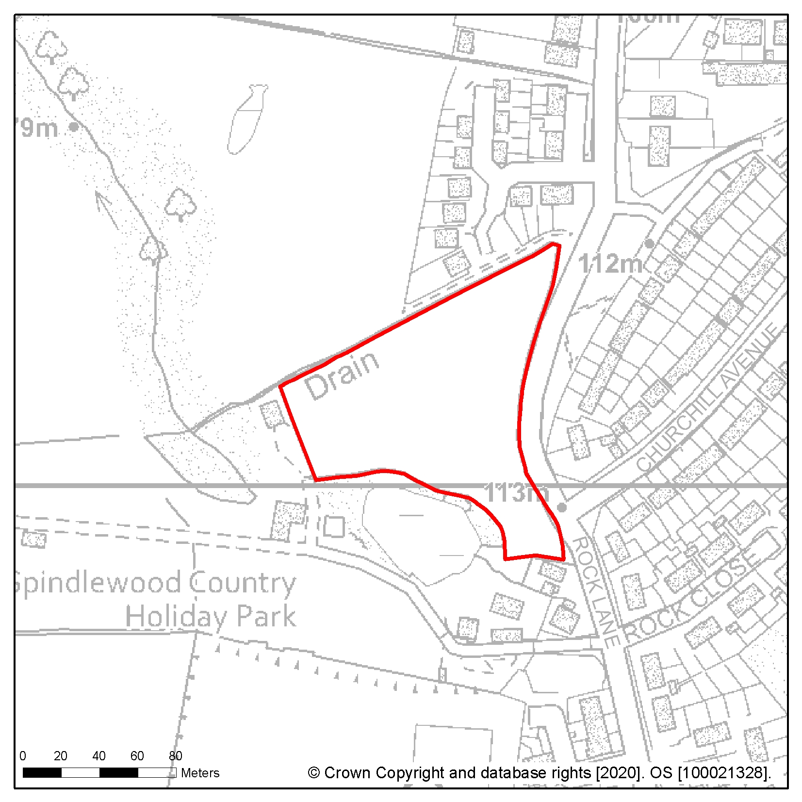
Site reference: HL11 Site name: Cinque Ports Way (former Stamco timber yard and TA centre)
Focus Area/Strategic Policy: Focus Area 4: West Marina and West St Leonards
Use: Residential led mixed use scheme to include commercial
Indicative capacity (net residential dwellings/floorspace): 25
Site specific development considerations based on draft Local Plan policies:
Development on this site should:
- Provide up to 25% affordable housing, with reduced affordable housing accepted to enable leisure and cultural uses to be accommodated
- Explore opportunities for co-ordinating development with the Seaside Road site (HL9), or allowances made to better enable this. Road and junction improvements should be considered in conjunction with the Seaside Road site (HL9)
- Enhance access to the public right of way and national cycle route that runs along the southern boundary and to the pedestrian walking and cycling routes to West St Leonards Station to improve connectivity
- Provide a public realm and promenade that is attractive and inviting to residents and tourists, and encourages foot or cycle journeys to the Bexhill Road local Centre and Central St Leonards District Centre to the east
- Avoid or mitigate against any adverse impacts on the Bulverhythe Shingle Beach and Cliffs Local Wildlife Site to the west including the provision of offsite buffer landscaping
- Include flood protection and mitigation measures given the sites location within Flood zones 2 and 3, including safe evacuation measures
- Include plans for the maintenance and improvement of the existing sea defences including improvement and maintenance of the seawall
- Have discharge rates agreed with the Pevensey & Cuckmere Water Level Management Board (PCWLMB) prior to granting of permission. This site also has a high groundwater table and drainage design should be informed by onsite monitoring
- Ensure future access to the existing sewerage infrastructure for maintenance and upsizing purposes is maintained. It should also take account of Southern Water's underground infrastructure in the design of the layout of the site. Easements would be required, which may affect the site layout or require diversion, and these should be clear of all proposed buildings and tree planting
The following image shows a map of the site boundary.
Site reference: HL23 Site name: 12-19 Braybrooke Terrace
Focus Area/Strategic Policy: Focus Area 1: Hastings Central
Use: Residential
Indicative capacity (net residential dwellings/floorspace): 20
Site specific development considerations based on draft Local Plan policies:
Development on this site should:
- Provide 25% affordable housing in line with policy SP2
- Provide innovative solutions for access and any necessary on-site parking, where parking can be justified in line with policy DP7: this is a relatively narrow site that is bound by high retaining walls and significant level changes adjacent to it
- Ensure that the quality of the amenity of future occupants, including access to daylight within buildings, is maximised and acceptable given the high retaining walls and limited rear aspect of the site
- Take account of Southern Water's underground infrastructure in the design of the layout of the site. Easements would be required, which may affect the site layout or require diversion, and these should be clear of all proposed buildings and tree planting
- Ensure the retention of trees to the north of the site, adjacent to it and within Linton Gardens (a locally important heritage asset)
- Consider that this site has a high groundwater table and drainage design should be informed by onsite monitoring
- Sustain and enhance the significance and setting of Linton Gardens
The following image shows a map of the site boundary.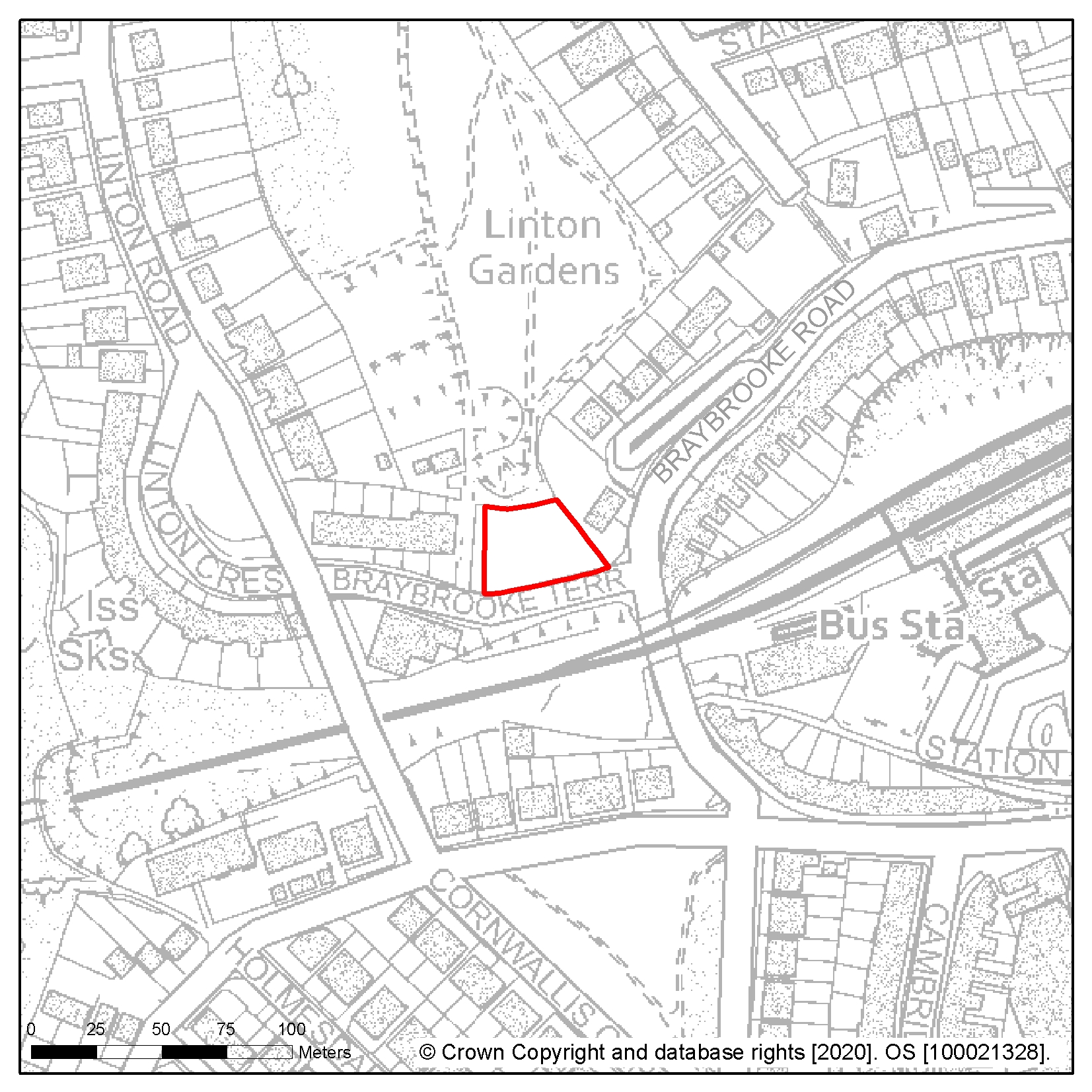
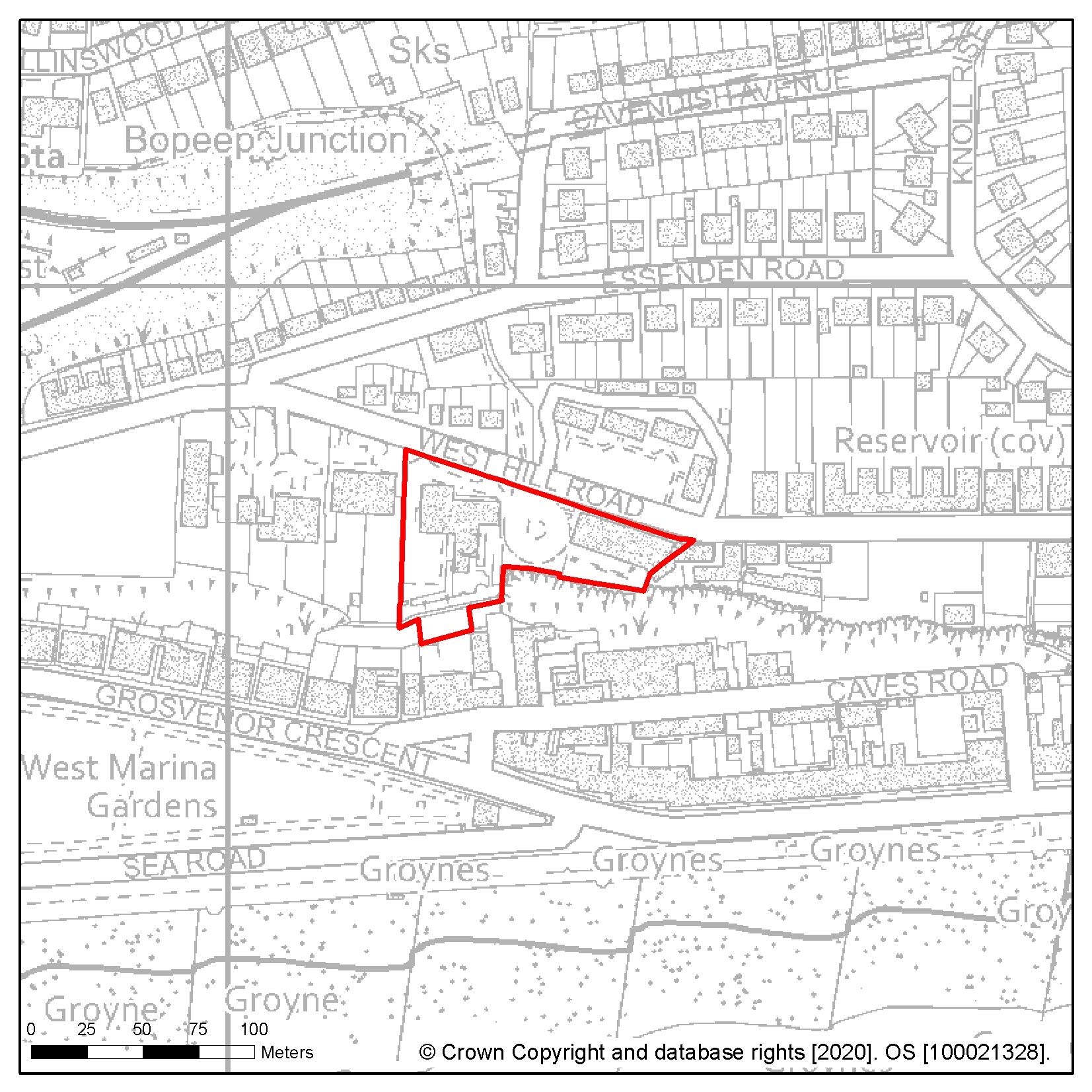
Site reference: HL111
Site name: Gambier House, 111 West Hill Road and West House, 115 West Hill Road
Focus Area/Strategic Policy: Focus Area 4: West Marina and West St Leonards
Use: Residential
Indicative capacity (net residential dwellings/floorspace): 20
Site specific development considerations based on draft Local Plan policies:
Development on this site should:
- Provide 25% affordable housing in line with policy SP2
- A vacant building credit will be applied to this site subject to criteria being met (see: National Planning Practice Guidance on vacant building credits)
- Retain and restore Gambier House and West House buildings together with infill development, or demonstrate how demolition provides a better design response
- Consider proposals that include removal of unsympathetic or out of keeping additions to the buildings in order to better reveal the original design as this will be supported
- Ensure the existing access point is utilised
- Not include development beyond the southernmost point of the existing buildings as it will not be permitted
- Provide public open space to the south of the site
- Avoid or mitigate against adverse impacts on the adjacent Caves Road Cliffs Local Wildlife Site
- Sustain and enhance the setting of the Grosvenor Gardens Conservation Area
- Provide innovative solutions for any necessary on-site parking that do not dominate the site
- Have discharge rates agreed with the Pevensey & Cuckmere Water Level Management Board (PCWLMB) prior to granting of permission. This site also has a high groundwater table and drainage design should be informed by onsite monitoring
The following image shows a map of the site boundary.
Site reference: SIEA1 Site name: Queensway Corridor
Focus Area/Strategic Policy: Strategic Industrial Employment Area (Strategic Policy 3)
Use: Industrial
Indicative capacity (net residential dwellings/floorspace): 29,878sqm
Site specific development considerations based on draft Local Plan policies:
Development on this site should:
- Provide high quality business development
- Contribute to transport improvements on The Ridge
- Explore boundary landscaping and other measures to reduce impact on existing residential, caravan and touring provision within this area
- Investigate the impact of land stability and contamination and incorporate mitigation measures as appropriate
- Ensure the impact of potential pollution and hazards to users and neighbours is properly considered and mitigated
- Improve pedestrian connections to nearby residential areas, open spaces and the Combe Valley Countryside Park/AONB where appropriate
- Take account of Southern Water's underground infrastructure in the design of the layout of the site. Easements would be required, which may affect the site layout or require diversion, and these should be clear of all proposed buildings and tree planting
- Include appropriate drainage measures, taking into account all sources of flooding and elevated groundwater tables in some parts of this area.
- Assess environmental and ecological impacts, including any hydrological effects of drainage into the Marlin Valley stream and propose appropriate mitigations, including suitable policy compliant 'greening' measures
The following image shows a map of the area boundary.

Site reference: SIEA2 Site name: Ivyhouse Lane
Focus Area/Strategic Policy: Strategic Industrial Employment Area (Strategic Policy 3)
Use: Industrial
Indicative capacity (net residential dwellings/floorspace): 11,464sqm
Site specific development considerations based on draft Local Plan policies:
Development on this site should:
- Allow for boundary landscaping to provide a visual and audio buffer to The Ridge and be enhanced where a development fronts the road
- Demonstrate the conservation and enhancement of the Area of Outstanding Natural Beauty showing how adverse impacts will be avoided
- Boundary landscaping and other measures to reduce impact on existing residential and caravan and touring provision within this area should be explored
- Preserve existing rights of way and retain wildlife corridors
- Ensure the impact of potential pollution and hazards to site users and its neighbours is properly considered and mitigated
- Contribute to improved transport infrastructure, particularly for pedestrians, cyclists and public transport, including the improvement of non-motorised access to the countryside
- Contribute to transport improvements on The Ridge
- Take into account the Borough boundary and the wider area within Rother District
- Take account of Southern Water's underground infrastructure in the design of the layout of the site. Easements would be required, which may affect the site layout or require diversion, and these should be clear of all proposed buildings and tree planting
- Take account of the Southern Water assessment that shows local sewerage infrastructure in closest proximity has limited capacity to accommodate the proposed development. Proposals for development at this site will generate a need for reinforcement of the wastewater network in order to provide additional capacity to serve the development. This reinforcement will be provided through the New Infrastructure charge to developers, and Southern Water will need to work with site promoters to understand the development program and to review whether the delivery of network reinforcement aligns with the occupation of the development. Connection of new development at this site ahead of new infrastructure delivery could lead to an increased risk of flooding unless the requisite works are implemented in advance of occupation
- Demonstrate the conservation and enhancement of the Area of Outstanding Natural Beauty (AONB) by undertaking a Landscape Assessment, providing an appraisal of the impact on the AONB and demonstrate how adverse impact will be avoided
The following image shows a map of the area boundary.

Site reference: SIEA3 Site name: Ponswood
Focus Area/Strategic Policy: Strategic Industrial Employment Area (Strategic Policy 3)
Use: Industrial
Indicative capacity (net residential dwellings/floorspace): 1,109sqm
Site specific development considerations based on draft Local Plan policies:
Development on this site should:
- Consider that this area is suited to densification and upward extension
- Ensure the impact of potential pollution and hazards to site users and its neighbours is properly considered and mitigated
- Fully assess environmental and ecological impacts and provide appropriate mitigations, including suitable policy compliant 'greening' measures
- Take account of Southern Water's underground infrastructure in the design of the layout of the site. Easements would be required, which may affect the site layout or require diversion, and these should be clear of all proposed buildings and tree planting
- Contribute to improved transport infrastructure, particularly for pedestrians, cyclists and public transport
The following image shows a map of the area boundary.
Site reference: SIEA4 Site name: Bulverhythe Estate
Focus Area/Strategic Policy: Strategic Industrial Employment Area (Strategic Policy 3)
Use: Industrial
Site specific development considerations based on draft Local Plan policies:
Development on this site should:
- Consider that this area is suited to renewal, with some densification
- Ensure the impact of potential pollution and hazards to site users and its neighbours is properly considered and mitigated
- Fully assess environmental and ecological impacts and provide appropriate mitigations, including suitable policy compliant 'greening' measures
- Take account of Southern Water's underground infrastructure in the design of the layout of the site. Easements would be required, which may affect the site layout or require diversion, and these should be clear of all proposed buildings and tree planting
- Improve access arrangements for vehicles and pedestrians
- Investigate the impact of land stability and contamination and incorporate mitigation measures as appropriate
- Improve pedestrian connections to nearby residential areas, shopping areas, open spaces and the Combe Valley Countryside Park where appropriate
- Explore boundary landscaping and other measures to reduce impact on existing residential provision within this area
The following image shows a map of the area boundary.

Site reference: SIEA5 Site name: York Road
Focus Area/Strategic Policy: Strategic Industrial Employment Area (Strategic Policy 3)
Use: Industrial
Site specific development considerations based on draft Local Plan policies:
Development on this site should:
- Consider that this area is suited to renewal
- Ensure the impact of potential pollution and hazards to site users and its neighbours is properly considered and mitigated
- Fully assess environmental and ecological impacts and provide appropriate mitigations, including suitable policy compliant 'greening' measures
- Take account of Southern Water's underground infrastructure in the design of the layout of the site. Easements would be required, which may affect the site layout or require diversion, and these should be clear of all proposed buildings and tree planting
- Improve pedestrian connections to nearby residential areas, Silverhill district centre and open spaces
The following image shows a map of the area boundary.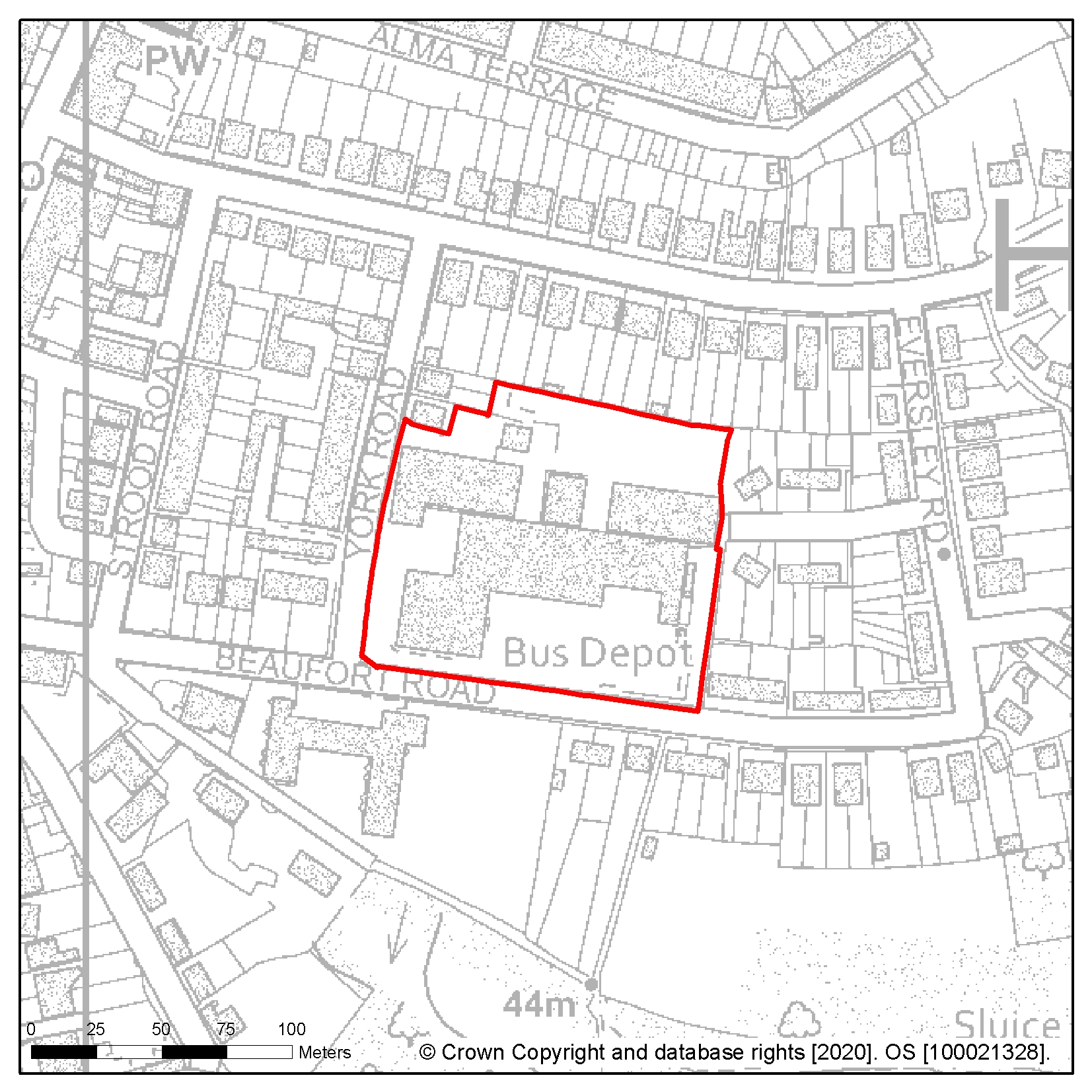
Site reference: HL101 Site name: Priory Meadow, Queens Road (upper levels)
Focus Area/Strategic Policy: Focus Area 1: Hastings Central
Use: Mixed use, incorporating residential on upper levels
Indicative capacity (net residential dwellings/floorspace): minimum 20
The following image shows a map of the site boundary.

As identified in our Strategic Housing and Employment Land Availability Assessment the following small sites (less than 20 units) are all suitable, available and deliverable for development over the lifetime of the Plan and are also currently counting towards our housing land supply requirement.
|
Site reference |
Site name |
Use |
Indicative capacity |
|
HL100 |
Land at Chiltern Drive |
Residential |
6 |
|
HL66 |
24 and land east of 16-24 Ironlatch Avenue |
Residential |
7 |
|
HL5 |
Former Spyways School, Gillsmans Hill |
Residential |
8 |
|
HL81 |
Land rear of 419-447 Bexhill Road |
Residential |
16 |
|
HL78 |
43-45 Queens Road (upper floors) (Focus Area 1) |
Residential |
5 |
|
HL104 |
Car park, 35 Shepherd Street |
Residential or mixed use |
9 |
|
HL34 |
4-5 Stockleigh Road |
Residential |
12 |
|
HL28 |
37 Charles Road West (Former Filsham Nurseries) |
Residential |
9 |
|
HL75 |
Land south of 15-20 Gresley Road, Lancaster Road |
Residential |
5 |
|
6HL73 |
Land adjoining 142 Bexhill Road |
Residential |
6 |
|
HL44 |
Church Street |
Residential |
5 |
|
HL70 |
Castlemaine, 4 Avondale Road and Castlemaine Cottage, 5 Gillsmans Hill |
Residential |
7 |
|
HL83 |
Roebuck House, 26-27 High Street |
Residential |
9 |
|
HL42 |
107 The Ridge (Simes and Sons) |
Residential |
8 |
|
HL45 |
309-311 Harold Road |
Residential |
7 |
|
HL58 |
Former Hare and Hound, 391 Old London Road |
Residential |
10 |
|
HL24 |
Silver Springs Medical Practice, Beaufort Road |
Residential |
9 |
|
HL30 |
West Hill Reservoir |
Residential |
14 |
|
HL61 |
14 Westfield Lane |
Residential |
14 |