Hastings Local Plan Consultation Draft (Regulation 18)
4. Development Focus Areas
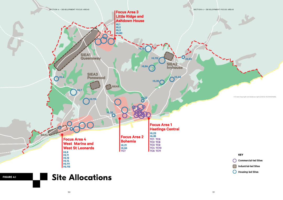
4.1 The Council has identified 'Site Allocations' for growth and development which are central to the delivery of the Local Plan targets for new homes and employment floorspace (illustrated on Figure 4.1). These sites are capable of delivering at least 20 homes and/or accommodating more than 500 sqm of commercial floorspace. Appendix 1 includes a schedule detailing uses that are acceptable on these sites, as well as indication of the development capacity – that is the number of new homes or amount of new commercial floorspace likely to be appropriate and other site specific planning considerations. A number of additional smaller sites that will contribute to achieving our housing target are also identified as site allocations.
4.2 The most growth, evident by large concentration of site allocations or site allocations with high capacities, is clustered in four areas:
- Hastings Central
- Bohemia
- Little Ridge and Ashdown House
- West Marina and West St Leonards
4.3 Specific policy guidance to ensure that development in these 'Focus Areas' is managed and coordinated are set out in Focus Areas Policies 1 to 4. The reasons for these draft policies are set out below.
4.4 The Hastings Central Focus Area sits between Hastings Old Town, which is immediately to the east, and Central St Leonards to the west. Collectively these areas, with their distinctive characters, already offer a diverse range of shopping and leisure experiences. A strategy of reinforcing the commercial function of Hastings Central complements the charm and scale of the Old Town, and the established cultural offer in Central St Leonards. Hastings Central provides a great platform for regeneration. The development and occupation of offices within the Priory Quarter will strengthen confidence in the area and help to generate significant footfall.
4.5 Hastings Central is a great opportunity for the revitalisation of the town but anyone who lives and works in Hastings will know that there are significant challenges. The closure of the university campus in the town centre in 2019 left a void. Occupancy rates in Hastings Town Centre are over 90%, but nationally, retail is a changing sector, and online retail has exploded over the last 10 years37. It has been widely reported that the future of many national retailers is uncertain, and this includes Debenhams, which has a store in our town centre. Challenges for the retail and leisure sector, and commercial development more broadly, are likely to be exacerbated by the impact of Covid-19, which is reinforcing trends towards increased internet shopping and remote working.
4.6 The town centre needs a new purpose. To enable this, in a challenging context, we want to provide maximum flexibility to enable the delivery of new mixed-use development with a focus on job creation, expanding the draw of the town beyond just traditional retail. This mirrors the new flexibilities the Government has introduced allowing changes between certain commercial and community uses to support town centre recovery38. 'Meanwhile uses', that is temporary changes to the use of a building in the town centre, may also have a role in supporting the town centre in the short to medium term. Residential development could also be part of the town centre mix. A bigger residential community in Hastings Central would also contribute to the vitality and viability of the town centre.
4.7 The success of the town centre is inhibited by major transport and public realm issues. Parts of the town centre have been pedestrianised, but there is a lack of consistency in design resulting in a variety of paving materials and street furniture, such as bollards. Improving the attractiveness and useability of the public realm in conjunction with changing our approach to parking in an area with high transport accessibility is key to our strategy.
4.8 Bohemia Focus Area presents an opportunity to create a distinctive new quarter in our town39. This will mean redefining this space and its relationship with the wider town. At present the Bohemia area is varied in both character and role. Summerfields comprises the area to the north of Bohemia Road, from Horntye Park through to Hastings Museum and the Local Nature Reserve – Summerfield Woods. It includes Summerfields Leisure Centre, the town's main leisure centre, which, over the lifetime of the plan will need to be replaced with a new facility. White Rock Gardens includes the public open space south of Bohemia Road and north of St Margarets Road divided by Falaise Road. The area to the west of Falaise Road is underutilised with poor connections to the seafront.
4.9 The area to the north of Bohemia Road has the potential for a new residential neighbourhood, with a range of high quality housing types that include affordable homes. Realising this will mean relocation of the SECamb make-ready station and the current Summerfields Leisure Centre. It won't mean the loss of the leisure centre which is well used.
4.10 Consolidation of indoor and outdoor leisure uses to the west of Falaise Road would enable the creation of a new sports park incorporating a new replacement leisure centre. The town centre location, and proximity to the buzz of St Leonards also points to the opportunity to reinforce and enhance the leisure and cultural offer in this area. The transformation of this area will require a comprehensive approach to development, but also has the potential to create new opportunities for the town, local businesses and residents.
4.11 The Little Ridge and Ashdown House Focus Area is in a part of north west Hastings which is characterised by low-density suburban housing. Higher quality, medium density development could contribute to meeting our housing target and delivering the homes we need. Enabling residential layouts less driven by accommodating a high number of parking spaces could allow distinctive new development accommodating not just family housing but other types of accommodation.
4.12 More sustainable travel options – opening up access to bus, cycle and walking routes is critical to supporting higher densities and to reducing the already significant congestion issues on The Ridge. Later in the Local Plan period we may review and revisit the future use of commercial sites fronting Sedlescombe Road North and potentially the NHS St. Anne's/Woodlands site, if this is not required for health-related uses. Expanding residential development could, in the long term, provide the 'critical mass' to trigger improvements to critical infrastructure and an opportunity to consider what longer-term change in the commercial area west of Sedlescombe Road North could look like. For now, however, the focus is on the Little Ridge and Ashdown House Focus Area and realising our longstanding plan for high quality new homes.
4.13 We want West St Leonards to come to life, building on the burgeoning independent shops and drawing people and investment along the coast. The area is already home to an established and vibrant residential community and a range of businesses. This Focus Area accommodates a range of building types, including some higher density forms of development. The area is low-lying and parts of it are in a designated flood risk area. Getting adequate flood mitigation measures and drainage in place is a significant challenge here. Despite these constraints, there are opportunities for innovative and high quality development in this Focus Area. It is well connected to mainline rail services, walking and cycling routes, green spaces and the seafront.
4.14 The former bathing pool site at the heart of the area remains one of the most prominent development sites on Hastings seafront. Sites at West Hill Road and the former West St Leonards primary school also have development potential. Development of these sites could make an important contribution to the local housing offer in this attractive location and provide new, accessible open spaces. Initial masterplanning work has informed the draft policy in response to constraints and opportunities40.
Focus Area Policy 1 (FA1): Hastings Central
- The Council will support a variety of land uses in Hastings Central to encourage a mixed- use vibrant town and will support development of:
- Employment generating uses including: retail, office, light industrial, studios, leisure, cafés, restaurants, visitor facilities (including hotels), education facilities (including language schools) and where appropriate pubs and drinking establishments. Intensification and expansion of commercial uses at Priory Meadow will be supported.
- Residential uses including student accommodation for institutions located in Hastings, are acceptable as part of a mixed-use development in this location (including Priory Meadow), providing it does not prejudice the commercial function of the area.
- Uses that support active frontages will be expected at ground level to enliven the street environment.
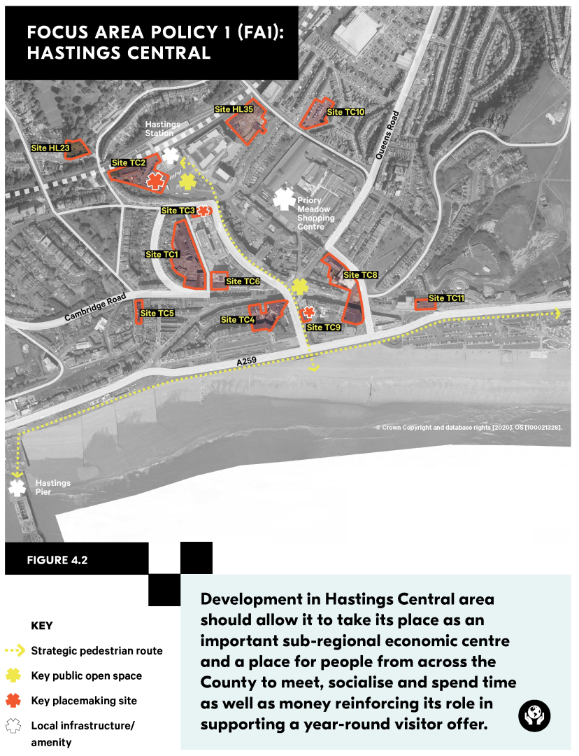
- Development near Hastings Station should better frame the arrival to the town and station as a central gateway and contribute to improving the public realm including integration with buses and a better pedestrian environment.
- Queensbury House (TC3) is a particularly important gateway opportunity site with potential for a taller building and a high-quality design response that supports placemaking at the station plaza, including a strong active frontage.
- The Harold Place site (TC9) should provide a high-quality development at the seafront gateway to the Town Centre and create a strong focal point between the two.
- The pedestrian routes between Hastings Station and the seafront and along the coast should be reinforced and improved. Improvements to the public realm and signage will be supported along with interventions that reduce barriers to, or open up access to, these areas.
- The transport and services access in this area make it particularly appropriate to higher density, potentially taller development (including in excess of the 4-5 storey prevailing building heights) where these make a positive contribution to the townscape.
- Pedestrian movement should be prioritised throughout the area along with investment in cycle infrastructure. Opportunities should be taken to rationalise and intensify the use of existing parking provision.
- Sites within this focus area will be vulnerable to a range of flooding including, but not limited to tidal, groundwater, surface water and drainage issues. Proposals for development must therefore provide details for flood risk mitigation informed by appropriate modelling.
Figure 4.2 Focus Area Policy 1: Hastings Central map
Focus Area Policy 2 (FA2): Bohemia
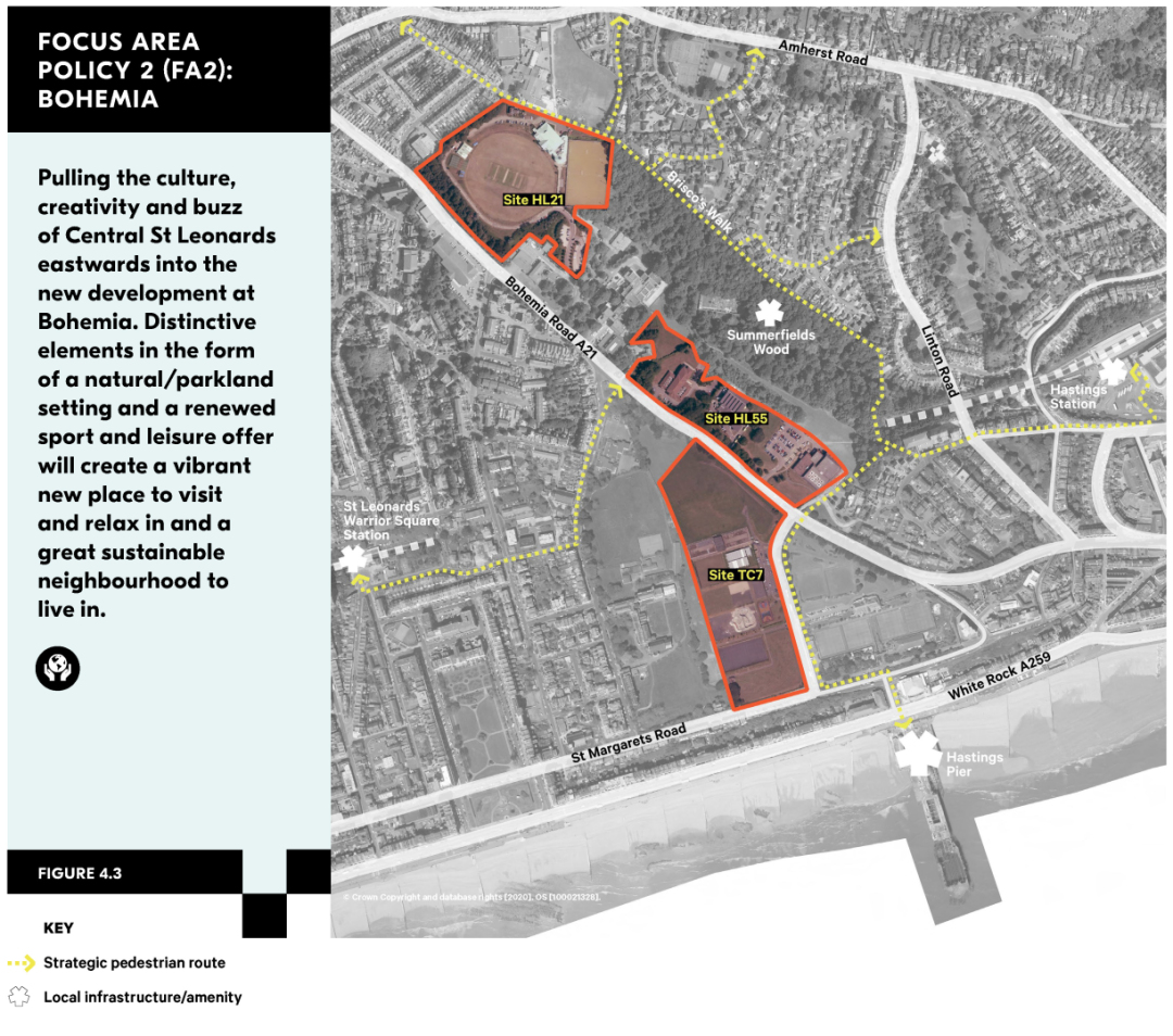
- The Council will support the comprehensive redevelopment of Bohemia to deliver indoor and outdoor sport/leisure uses at White Rock Park (TC7) and cultural uses as part of a new mixed-use residential neighbourhood centred on the Summerfields (HL55) and Horntye (HL21) sites. Smaller scale retail or office uses will also be acceptable in this location.
- Redevelopment at Horntye (HL21) for residential development is subject to the satisfactory relocation of the existing sports facilities. Residential development may be permitted within White Rock Park (TC7) where this will facilitate the delivery of sports, leisure and cultural facilities.
- Higher density development will be permitted for development on sites north of Bohemia Road.
- Direct and legible connections should be provided to St Leonards Warrior Square Station and Hastings Station, and pedestrian movement should be prioritised throughout the area incorporating clear signage, crossing points, and generous pavements.
- The design of any new routes must be visually attractive, provide easy navigation to the stations/public transport and should prioritise this movement in the order of pedestrians, cyclists and car users.
- A clear hierarchy of public spaces should be provided, which are well integrated with the surrounding areas.
- The design of the development should be sensitive to Summerfields Woods containing measures to protect the woodland setting, heritage assets and ecology and increase the biodiversity value across the whole of Bohemia.
- District Heating should form part of the development if feasible and development should be carbon neutral.
Figure 4.3 Focus Area Policy 2: Bohemia map
Focus Area Policy 3 (FA3): Little Ridge and Ashdown House
- The Council will support the creation of a new residential neighbourhood in the Little and Ridge Ashdown House area comprising three connected residential areas.
- Development east of Harrow Lane, should include a mixture of housing typologies on site including terraced housing and where appropriate and viable medium density apartments blocks.
- Development east of Harrow Lane should also enable the incorporation of a bus-only route bypassing congestion on The Ridge necessitating the provision of new junctions from the Ridge and at Harrow Lane.
- Redevelopment of Ashdown House (HL80) should provide residential development and adopt a more imaginative approach to the market offer in this part of the Borough. High- quality residential accommodation offering a mix of housing types will be supported.
- Development in this area should maximise the use of land through the design of an efficient layout with less space for parking and enabling the provision of more homes, landscaping and pocket parks.
- Pedestrian connections between sites should be improved with a focus on connecting new pocket parks to the east of Harrow Lane through to Ashdown House.
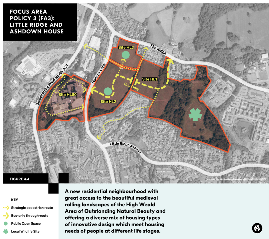
Figure 4.4 Focus Area Policy 3: Little Ridge and Ashdown House map
Focus Area Policy 4 (FA4): West Marina and West St Leonards
- The Council will support development of residential uses alongside commercial, leisure and cultural uses which attract residents from the wider Borough and visitors to Hastings.
- The Seaside Road site (HL9) and adjacent Cinque Ports Way site (HL11) are central to the delivery of aspirations for this Focus Area. A coordinated approach to development of these sites is encouraged. Priority will be given to arts, culture and other year-round visitor attractions and visitor accommodation. Retention or relocation of existing beach huts should be accommodated. Redevelopment of Gambier and West House (HL111), the former Malmesbury House (HL12) and West St Leonards Primary School (HL115) sites for residential development will be supported.
- New high quality open spaces should be provided in this Focus Area including:
- A new central square at the heart of the Seaside Road site (HL9) (over the undevelopable wastewater reservoir) should incorporate a landscape character of sand and shingle, planting and materials drawing on the seaside setting, and the natural surveillance and enclosure to this space;
- Creation of new public open space to the north west on the Former West St Leonards Primary School site (HL115) and safeguarding of the adjoining South Saxon Local Wildlife Site in the layout. Opportunities to create a feature of the ecologically important Hollington Stream, in the southern and western part of the site should be explored.
- Within the Seaside Road site (HL9) development ranging from 2-3 storey houses up to 4-5 storey apartment blocks may be appropriate; these should not dominate the site. There is potential for a taller, landmark building to the west of site HL11 at Cinque Ports Way. Arts, culture, leisure and other year round commercial attractions should be provided as part of the overall mix within HL9 and HL11. Sea views should be considered in the overall design avoiding an overly rigid geometrical arrangement allowing sea views between 'gaps' in the built form as can be experienced elsewhere in the Borough.
- The seafront walkway and cycleway should be retained and enhanced, and pedestrian and cycle routes to West St Leonards Station, local schools and nearby bus routes reinforced from all sites.
- Car parking should be minimised in this Focus Area given the high public transport accessibility. Where parking is provided, integrated sensitively into the wider design of sites prioritising movement of pedestrians, cycles and cars in that order.
- Seawall improvements and ongoing maintenance and other flood and coastal change risk mitigation measures should be factored into development across this focus area which is located in a coastal area of the Borough vulnerable to the effects of flooding and coastal change.
- All sites in this area will be required to undertake appropriate groundwater monitoring and obtain discharge consent from the Pevensey and Cuckmere Haven Water Board prior to planning consent being granted.
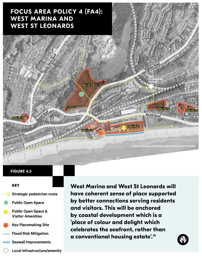
Figure 4.5 Focus Area Policy 4: West Marina and West St Leonards map

